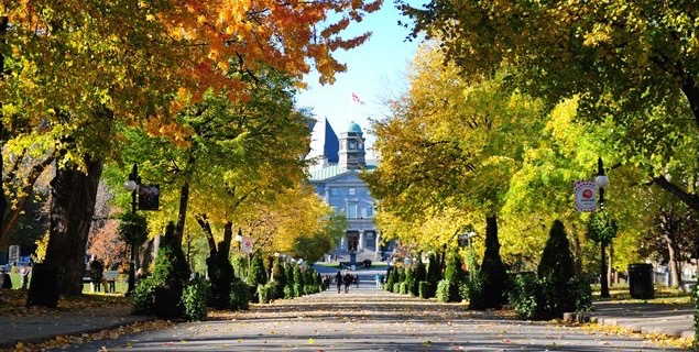
Geothoughts Conversations 4 explores our key research outcomes and influences, and was held near McGill University’s downtown campus in Montreal, Quebec. (Image courtesy of http://jeannesauve.org)
By Sam Lumley
We’re excited to present our 4th episode of Geothoughts Conversations!
This episode recounts a conversation held in June 2018 in the Montreal, QC home of Geothink Head Renee Sieber, a McGill University associate professor in the Department of Geography and School of Environment. It highlighted key research outcomes and influences over Geothink’s journey from beginning to end.
In this episode, we take a look back over five years of fruitful Geothink research. We spoke to Geothink Head Renee Sieber, Co-Applicants Rob Fieck, Daniel Paré and Stéphane Roche, and Geothink students Rachel Bloom and Edgar Baculi about their most memorable experiences with the grant.
Thanks for tuning in. And we hope you subscribe with us at Geothoughts on iTunes. A transcript of this original audio podcast follows.
TRANSCRIPT OF AUDIO PODCAST
Welcome to Geothoughts. I’m Sam Lumley.
[Geothink.ca theme music]
“The Geothink grant that was funded by the social science and humanities research council of Canada is coming to an end. We have done great work in terms of creating new theories, new frameworks, new applications, new data sets new collaborations.”
That was Geothink Head Renee Sieber, an associate professor at McGill University’s Department of Geography and School of Environment. Funded by Canada’s Social Sciences and Humanities Research Council, the Geothink partnership grant has involved 26 researchers and 30 partners, while also training more than 100 students. As the grant wraps up, we’ve been hearing from our researchers and students as they reflect on their involvement in the grant over the past five years.
We started off by speaking to former Geothink student Rachel Bloom about her most memorable experiences with the grant.
“I was the lead of Geothink’s Open Data Standards project when I was a student at McGill University. The most memorable Geothink experience would have to be designing a survey that I delivered to open data publishers at cities in north america about open-data standards. It’s memorable because it was a really challenging process due to my research topic being so new. And it also helped me develop my skills as a researcher for the future.”
The Geothink grant has brought together researchers from many different backgrounds and from different parts of the world. It was this point that Geothink co-applicant Rob Feick, an associate professor in Waterloo University’s School of Planning, emphasised while talking about the influence of Geothink on his own work.
“My research has really benefited from my work with Geothink in a few ways, one of which is Geothink is really a multi disciplinary network. It’s a network of people that span disciplines from geography, law, planning and a host of others. And having these different types of expertise around the table has really helped ground my research.”
“It’s also very applied work we’re working with local regional governments on problems that matter to people, both problems that matter to people right now and those that people are seeing both in the research community and in applied context, coming down the pipe in future years. So one of the ways, just using special data quality as of those areas that a number of us have been looking at and that that I have really benefited from in my exposure in Geothink, is understanding that it is far less of a technical matter and it’s a combination of technical and a social and governance matter, and we’re starting to understand that something that we thought was relatively simple, of spatial data quality, is much more complex.”
This interdisciplinary approach was also highlighted by Sieber, as being essential to exploring how interactions between citizens and government are mediated by technology.
“It’s been marvelous in terms of the interdisciplinary of bringing together geographers lawyers, people in the private sector, people in government to work on issues of what’s happening to the conversations between citizens and cities. And on how can we make sure the technology is not an impediment, but actually enhances that conversation”
Working alongside people from different academic fields can help to offer a broader perspective on the big issues facing citizens and governments. It also led some Geothink researchers to shift their own own research interests. This was the case for Geothink Co-Applicant Stéphane Roche, an associate professor in University Laval’s Department of Geomatics, who talked about his focus moving from the technical to the ethical over the course of the grant.
“My main interest within Geothink was more about social inclusion within a smart city context, spatial justice and ethics, which was quite far from what I was supposed to do at the beginning. So in my case, the move was quite big. Geothink is as a network different sectors, different disciplines, different expertise, and working on these issues around the relationship between spatial and social justice, cities and technology. And that that was really remarkable. I really enjoyed and appreciated the the dynamism and the motivation of our group of students, some of them coming from law, some others from engineering some from social science. And it was really rich in term of interaction.”
Throughout the grant new partnerships and opportunities have emerged, and co-applicant Daniel Paré, an associate professor in the University of Ottawa’s Department of Communication and School of Information Studies, highlighted his new collaborations with the Open Government Partnership.
“My involvement with Geothink has influenced my research in so much as it has opened the door towards getting to work with OGP partnership. So based on my Geothink work in open data and open government, that’s transformed, if you will, into the role with the OGP. Where I’m responsible for overseeing assessments of the implementation of Ontario’s Open Data Action Plan.”
We went on to ask Paré about his most memorable experiences as part of the grant.
“I think the most memorable experience has been working with the great team that was put together, and that includes our great team of students that are brought together every year in terms of the student based meetings and such. So for me that’s always been a highlight of the team actually getting together physically and meeting over a period of three to four days. That’s been key; those sessions always been so rich on multiple levels.”
Opportunities for collaboration and exchange were facilitated by the four Geothink summer institutes. Many collaborators and partners emphasised how helpful it was to bring researchers, partners and students together under one roof. Feick pointed to 2015 Summer Institute held at McGill University as being his most memorable moment.
“I’ve had a lot of memorable moments in this in this project over the years, but I think the one that sticks with me the most was at a summer institute that we had for the Geothink students here at waterloo. The summer institutes are opportunities where students from a variety of different universities could come together and work on an applied problem and learn about a particular aspect of geospatial information and its interfacing with society.”
“Students in this particular summer institute had the task of developing an application. We had teams of students that hadn’t met before that came together over the course of a week and put together some really fantastic applications. And these applications, I think, spurred a lot of their own research that they were going to continue on with, but also was really interesting to see how again the different perspectives that the students brought, along with those people that were assisting them through the SI, actually came to fruition.”
The summer institutes also stood out to former Geothink student Edgar Baculi, now a graduate researcher in Ryerson’s Department of Geography.
“We have all these disciplines and I remember benefing greatly from talking to the economics student, sociologist, communication and journalism students on the topic open data and it opened my mind to the idea of, if we’re talking about open data it’s not just going to be the GIS people who are going to benefit or the academics, it’s going to be the sociology students, it’s going to be a journalist from the Toronto Star, it’s going to be all these people who need to understand what open-data is from their perspective and from other perspectives.”
“So, I would say, Geothink was very important in letting me know the inside from other perspectives. And as for networking, that’s a lot of disciplines to go through, and we were all from across canada, and I think actually a few of us were from the States, if I remember correctly, so it was a great networking experience. Many of them are still friends of mine on twitter and LinkedIn, so, great experience.”
The five-year Geothink Partnership Grant may be coming to its conclusion, but the research and its applications will continue. We asked Sieber what lay in store for Geothink’s research themes, the community the partnership helped to foster and the grant’s continuing work.
“We have transformed, I’m happy to say, the lives of over 100 students. I’d like to think that we transformed the lives of many people in the public sector and the private sector across canada. I know it has certainly transformed my life. It has transformed the life of the researchers involved in this project.”
“So while this grant ends, that doesn’t mean that Geothink as a concept, and a research trajectory has ended. Many of our apps will live on beyond us. Certainly our research and our own research trajectories have been changed as a result, so that work’s going to go on even after the grant ends. And, of course, we’re also looking for new grants to pursue this research!”
[Geothink.ca theme music]
[Voice over: Geothoughts are brought to you by Geothink.ca supported by generous funding from Canada’s Social Sciences and Research Council and generous donations from our grant partners.]
###
If you have thoughts or questions about this podcast, get in touch with Sam Lumley, Geothink’s digital journalist, at sam.lumley@mail.mcgill.ca.
In this final issue we celebrate the culmination of five years of successful Geothink
research and present reflections from our faculty and staff.
We also catch up with Geothink Co-Applicant Leslie Shade, former Geothink student Edgar Baculi, and 2017 Geothink Summer Institute attendees Local Logic.
If you have feedback or content for the newsletter, please contact the Editor, Sam Lumley.
In this issue, we celebrate the start of a new year by reflecting upon five successful Geothink&Learn webinars and highlighting exciting new Geothink research.
We catch up with Geothink Co-Applicant Teresa Scassa about her work on data deficits
in the sharing economy; Geothink Collaborator Muki Haklay about his new open course
on Citizen Science; former Geothink student Julia Conzon about her recent appointment
at Employment and Social Development Canada; and other grant news.
If you have feedback or content for the newsletter, please contact the Editor, Sam Lumley.
Geothink and the Center for Government Excellence (GovEx) at Johns Hopkins University launched a first-of-its-kind Open Data Standards Directory today that identifies and assembles standards for open data shared by governments.
By Sam Lumley
Geothink and the Center for Government Excellence (GovEx) at Johns Hopkins University launched a first-of-its-kind Open Data Standards Directory today that identifies and assembles standards for open data shared by governments. The new directory provides guidance on the best format for sharing specific types of data to ensure its interoperability across local, regional and national jurisdictions.
The site began as a Geothink project led by McGill University student Rachel Bloom and was supervised by Geothink Head Renee Sieber, an associate professor in McGill University’s Department of Geography and School of Environment. For her undergraduate honors research in the Department of Geography, Bloom developed a tool for searching and querying relevant open data standard for a diverse range of municipal open data. In partnership with GovEx, Julia Conzon and Nicolas Levy as McGill undergraduate students contributed to the project via visualizing and researching the directory.
Former McGill University student Rachel Bloom initiated the Open Data Standards Directory as her undergraduate honors project.
“I think one of the biggest challenges was providing this information in a way that was easily accessible in a dashboard format,” Bloom said. “It was difficult because the standards are complex and it’s hard to capture all of the desired information about them in an easy visual style based around our users.”
“The standards directory helps people not only know what’s out there,” she added. “But based on a systematic approach, it allows people to also evaluate the standard and help them on their decision of which one to adopt. So I think that’s really valuable.”
This initiative has been further developed by The Center for Government Excellence (GovEx) at Johns Hopkins University in partnership with Geothink and members of the open data community. It now represents the first ever international data standards directory. It helps governments provide data in formats that will most effectively support informed decision-making and the provision of services.
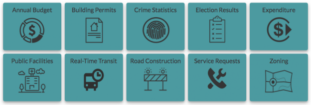
“There’s a serious need for coordination on how governments at all levels classify different types of open data,” Sieber said. “A collaboration with McGill University, this directory provides a comprehensive inventory of how data on transit, road construction, public facilities and more has been classified. It also allows evaluation of different standards to help guide governments in choosing the most useful ones.”
The project emphasizes a collaborative approach that opens a two-way dialogue with municipalities. This allows its creators to better understand what is valued within the decision-making process and to encourage the adoption of specific standards for how open data is released. Users around the world are able and encouraged to contribute additional information and update existing standards.
“Open data improves the lives of hundreds of millions of people, many incrementally and some dramatically,” Andrew Nicklin, GovEx Director of Data Practices, said. “Our new directory will encourage global standards for how data is organized for more effective production and consumption at scale. This will insure an even greater impact on the local government services level.”
Historically, city governments and others have faced several challenges in dealing with open data sets. Among these challenges is a lack of agreement and coordination on how data sets should be structured to best serve the public that are intended to be able to access them. The establishment and organisation of common standards can address this problem by encouraging practices that ensure data is accessible and usable by citizens. It can also ensure that datasets released by differing municipalities will be interoperable.
“The directory’s inventory helps simplify and demystify choices for governments and citizens by answering the question ‘what’s out there?’ but also takes it a step further by assessing the value of these standards to a city’s data provision,” said Jean-Noé Landry, Executive Director of OpenNorth, a Geothink partner in this work. “The directory allows us to align data practices, join up data, and enable emergent data uses. Data interoperability is one key to unlocking open data’s innovation potential and we believe this inventory is a very important step towards it.”
Currently there are over 60 standards on the directory from around the world and in multiple languages. GovEx hope to expand these efforts to continually broaden its range of standards, languages and user-bases.
To find out more about the open data standards directory project, you can listen to Geothink’s podcast on the initial project, catch an update on GovEx’s latest Datapoints podcast or visit the GovEx Beta Data Standards Directory website.
###
If you have thoughts or questions about the article, get in touch with Sam Lumley, Geothink’s newsletter editor, at sam.lumley@mail.mcgill.ca.
This past February, we had the pleasure of viewing new research from Geothink academics and students at the Spatial Knowledge and Information (SKI) Canada conference in Banff, Alberta. This two-day conference is special as it addresses a variety of issues ranging from Geographic Information Systems (GIS) techniques and tool-building to applied spatial statistics, particularly in the context of Canadian social issues.
Geothink Head, Dr. Renee Sieber, delivered the keynote address. She spoke on the “10 Things You Should Know About Engagement, Volunteerism, and Participation in Geospatial Technologies” and gave insights on how social theory and geospatial technologies coexist. She cautioned against treating technology as a black box and taking technical tools for granted, particularly if we do not completely understand them. Application of technology does not necessarily result in more or better participation. This is one of the potential issues of the drive towards data-driven decision making, particularly if we dispense with processes of democratic participation.
This year, Geothink co-applicant Dr. Scott Bell (University of Saskatchewan) presented findings on Local patterns of national household survey non-response in Canadian cities. He highlighted methodological issues with government collection of census data, such as the Global Non-response Rate (GNR) variable. Some cities which are very small but with a high GNR can be excluded from the final results due to issues of spatial autocorrelation and edge effects. City growth is also problematic for normalising census data to make comparisons, particularly when different divisions grow at different rates. Dr. Bell’s research team developed a variety of models to predict non-response and found correlations of non-response rates with other social variables such as whether the respondent was a renter or aboriginal in origin.
Geothink student Lauren Arnold (University of British Columbia Okanagan) spoke of The Potential Role of Open Data for Public Engagement in Environmental Assessment. Environmental assessments are highly dependent on spatial analysis and require datasets at very large spatial and temporal scales to calculate and predict cumulative effects of actions for the environment, society, and economy. Open data has the potential to address issues of public participation in environmental assessments and bring in more citizen involvement, improve transparency, and potentially even decision-making. Contextualising open data within Public Participation GIS (PPGIS), Arnold argued that open data can be another catalyst for integration of PPGIS into public consultation and decision-making processes.
Suthee Sangiambut (McGill University) presented an alternative view of his Master’s research findings. Looking at open data flow in civic apps, he noted that data undergoes transformations within government, at the developer, and in between. Data transformations are often done outside of government by data re-users, but the choices government makes in how it collects or distributes data will affect data reuse down the line. He also demonstrated that open data consumed through apps are not an exact one-to-one representation of data used in government and users should be aware that open data still represents a curation of sorts.
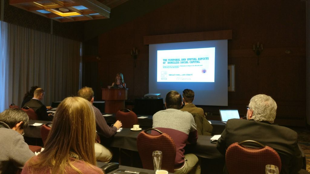
Shelley Cook (University of British Columbia Okanagan) won joint first prize for student presentations. She presented on The Temporal and Spatial Aspects of Homeless Social Capital and gave an in-depth look at how homeless is controlled by legislative and spatial tools, such as ‘red zones’, in Kelowna, BC. She found that the size of a homeless person’s geographic footprint (their coverage of the city) is related to their social capital; smaller activity spaces allow for less social capital. Homeless geographic footprint is also inversely related to dependency on services. However, once the homeless are provided housing, their geographic footprint shrinks.
Finally, Brennan Field (University of Saskatchewan) presented on Policy Mobility of Police Interactions Open-Data. Such policies cover data collected on police interactions with the public such as vehicle stops and fines. His research will look at how these data policies are spread across jurisdictions and departments, and how they are translated to the operational level.
This 5-9 April 2017, Geothinkers will be at the American Association of Geographers (AAG) annual meeting in Boston. For a list of presentations and panels to attend, see the programme guide here. We will be tweeting for the duration of the conference on Twitter (@geothinkca).
Media coverage in recent months may be focusing on Niantic’s continuous battle with Pokémon GO exploits and the game’s apparent demise, but here at Geothink we still see great potential in augmented reality (AR) games to promote community engagement. Our research examines communities and citizen-government engagement, particularly through geospatial technologies such as the geoweb. At the height of the craze, Pokémon GO resulted in conspicuous movements of people through engagement with a location-based service. This provides us with a convenient case study of the potential effects of a location-based service that causes movement of people through gamification. Geothink has also investigated gamification in urban planning and citizen engagement through platforms such as Minecraft and the precursor to Pokémon GO, Ingress. A recent publication from Geothink student, Lisa Mather Ward, and her supervisor, Dr. Pamela Robinson, has looked at Minecraft’s potential for public consultation.
Pokémon GO and Geography
Geothink co-applicant Dr. Claus Rinner (Ryerson University, Department of Geography and Environmental Studies) has written a post introducing geographic analysis concepts with Pokémon GO. In it, he writes about geographic distribution, catchment areas, and links them to geospatial analysis methods such as buffering, distance decay, and suitability mapping. Some of the built-in distributions of Pokémon (such as having certain types of Pokémon available for certain types of terrain, weather, continents, and time of day) are similar to what we look for in ecological species distribution. The same concepts and techniques are widely used by corporations conducting market research, retail analysis, and location intelligence. As such, Pokémon Go is a great way to introduce basic geographic concepts to students and the interested public.
A Medium for Contestation of Urban Places?
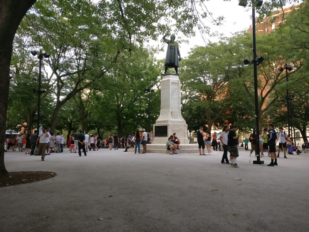
Movements of people that are a direct result of their interaction with a mobile app could result in new contestations of space and place. Pokémon GO is potentially one tool that influences and reassigns cultural identity and platial meaning. In downtown Montreal, we have seen a regular congregation of Pokémon trainers develop around Cabot Square to catch Pokémon, level up, and wrestle for control over its gym. Will this new influx of people change the identity of Cabot Square? Or has this already happened?
Pokémon Go (right) versus swing dancing (left) – is location-based gaming a new tool for contesting space and place? Photo credit: Suthee Sangiambut
Geothink Head, Dr. Renee Sieber (McGill University, Department of Geography and School of Environment), has spoken of the potential abuses or biases that may result from the placement of Pokémon and pokéstops on the map. Algorithms are the determinant for a pokéstop and Pokémon spawn locations. However, as Sieber emphasises, technology itself should never be assumed to be neutral. Implicit biases may be injected by programmers, managers of the technology, and the underlying data. For example, it has been noted that certain neighbourhoods are poorer in pokéstops, potentially due to the distribution biases in crowdsourced contributions that formed a part of the underlying pokéstop dataset.
On the other hand, does location-based gaming have the potential for real-world community building? Are players actually exploring their own communities?
Geothink co-applicant Dr. Stéphane Roche (Université Laval, Département des sciences géomatiques) and his PhD student, Territutea Quesnot have studied landmarks and wayfinding, particularly through social networks with gamified interactions such as FourSquare. As Roche notes, the concept of ‘checking in’ to a location is not new. Pokémon GO’s uniqueness is in its content and in overlaying the Pokémon universe over the real world (such as through the camera feature) with more integration than Ingress. For Roche, such movements of people could also be a form of contestation or appropriation of places. He defines an urban place as “an equation between a physical location, an event, and the name associated with the phenomenon”. Landmarks in the city can therefore have multiple ‘places’ depending on their usage. For example, a pond has one use during the summer, but turns into an ice skating rink during the winter. Pokémon GO, Roche says, “has created new urban places, in a location where existing places were already there”. Roche cautions us to not immediately condemn the phenomenon of Pokémon GO players congregating in large groups, as contestation and appropriation of urban places is not a new process. Pokémon GO itself has not had an entirely negative effect on urban environments and has been attributed as a factor in revitalising the Brussels community after this year’s terrorist attacks.
Roche is optimistic that “gamification and technology has the potential to improve our understanding of the world, improve our skills, including spatial skills, and could help people to discover new components of the world”, but also echoes Sieber’s concerns over algorithmic regulation where, “because of the choices that are embedded in the code and algorithms, there is a kind of orientation and social classification…and it becomes more and more difficult to discover new things”.
For Rinner, government should not have to resort to gamification to promote community engagement or citizen-government interaction, but he admits,
“I am afraid that it will soon be necessary to get anyone to do anything good. So, yes, I expect that government will soon use gamification to motivate people to engage in planning questions or politics. And more concerningly, I expect that businesses will use geolocation games to steer people to the right, or maybe wrong, places.”
AR and Gamification: Potential for Civic Engagement in Urban Planning
Regardless of Pokémon GO’s success, Geothink is looking to investigate the potential of AR in promoting civic engagement at the municipal level. Geothink co-applicant Dr. Pamela Robinson (Ryerson University, School of Urban and Regional Planning) has brought together a group of six masters’ of urban planning graduate students to investigate AR’s potential for the City of Toronto. Their mission is:
To explore the potential of AR technology in relation to public consultation & civic engagement by local governments and to provide a framework for analyzing future engagement opportunities
According to the students, AR has a high potential due to its fusing of the digital and physical. Unlike Virtual Reality (VR), AR does not completely remove the physical world and users can still interact with each other face-to-face, rather than being restricted to a virtual environment.
Currently at a preliminary stage of their project, the students have investigated the distribution of pokéstops and urban accessibility to pokéstops to examine the geographic reach of the game in the city. The density and location of check-in locations for any gamified service are crucial when attempting to attract people to a particular location, such as the location of a public consultation or town hall meeting and also important for evaluating how inclusive the tool can be in terms of reaching residents. The students discovered that a player’s experiences of Pokémon GO can really differ depending on where they live in Toronto.
Team PokéPlan (as they have named themselves) is also looking at other issues that a municipality will be concerned with, such as legal considerations (privacy, liability), language barriers, issues of service coverage and accessibility (the digital divide), and how to reach broad and target audiences, and finally gamification. According to Geothink student Corinna Prior, the City of Toronto has already begun to experiment with more flexible types of consultation such as the Planners in Public Spaces programme where planners go to the people. For Prior, “gamification is a really powerful tool. The potential to get people out and about is really powerful”. If AR and gamification could be used to support public consultation processes, we may experience radical changes in how citizens interact with their municipal governments.
More updates on TeamPokéPlan once their project ramps up. In November, Team PokéPlan will host a World Town Planning Day breakfast (November 8th), be the guest speakers at Civic Tech Toronto’s Hack Night (November 15th) and present their final report on November 22nd. For more information about their work please contact Pamela Robinson.
This is a guest post from Geothink student Qing Lu (Lucy), University of Waterloo, under Professor Peter Johnson. She writes about her recent experience in a Geothink student exchange.
By Qing Lu (Lucy)
In the middle of August, I had the opportunity to visit McGill University via the Geothink Summer Exchange Programme. Approaching the completion of my graduation thesis, I thought Dr. Renee Sieber and her team could help me identify the gaps of my research and add new insights. Dr. Sieber is the Principal Investigator of Geothink and her research on public participation and the geoweb, which is related to my research on municipal government mobile applications for 311 service requests. My research aims to determine the characteristics of communication channel use and identify advantages and challenges of the mobile app channel. Since my research is a new area that does not have an abundance of prior studies for reference, insights and opinions from experts and peers are important. I hoped to hear their perspectives on the potentials and issues of 311 apps for municipalities, more specifically, the impacts of 311 apps on efficiency of governments as well as on citizen engagement. Luckily, I got to meet our Geothink Student Coordinator, Peck Sangiambut, who has also looked at citizen engagement via civic apps (including a 311 service request app), under Dr. Sieber.
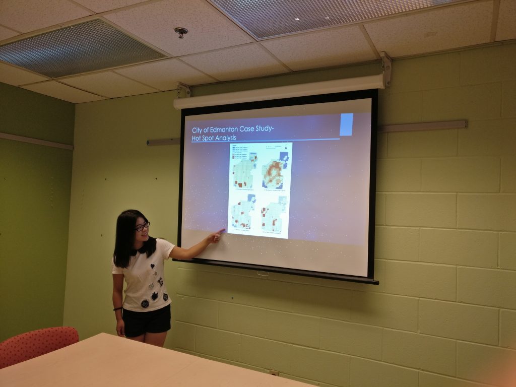
On the first day, I did a presentation for Dr. Sieber and her team. I presented my research on 311 apps and results of analysis of 311 requests in the City of Edmonton. A paper about this is published in the Urban Planning journal. In addition, I presented results of interviews with six municipalities about their perspectives on 311 app usage. Instead of a regular presentation that starts with presentation and wraps up with questions, it was a lively discussion that everyone exchanged opinions and ideas in the process of presentation, and we ended up an hour over our originally scheduled time! Dr. Sieber and her team were very outspoken and many of their points worth pondering. One of the things that I ignored in my research is the geographic offsets of 311 data obtained in open data catalogue. To protect the privacy of reporters, the locations of reported incidents are likely to be shifted from their actual geographic locations, for example, a tree pruning request points to the centre of a building. Therefore, the results of my spatial analysis of 311 data contain bias caused by inaccurate locations. In addition, efficiency could conflict with engagement when we know newly-introduced channels such as mobile apps are more efficient than telephone calls. Some people, especially the elderly, would be left behind if municipalities simply seek to maximise operational efficiency and perhaps reduce staffing for traditional channels of communication (such as telephone hotlines).
Presenting research results at the Department of Geography, McGill University
For the second day, Dr. Sieber’s team and I went to a panel discussion called GIS Without GIS: Spatial Technologies for Social Change. This was part of the World Social Forum and included discussion of the roles open data, mapping, and open source tools in producing social change. The invited speakers shared their opinions and experiences working with open data. This discussion inspired me to look at the open data aspect of my research as some municipalities publish the 311 data on the open data catalogue while others do not. It would be interesting to investigate if the openness of 311 reports impact citizens’ engagement.
This trip has provided me with the opportunity to communicate my research findings with people who work in the same field. I also got a deeper understanding of research – research is not only finding answers to questions but also seeking questions to be answered. In my research, I have found that there is a trend that mobile app use for citizens to contact governments is increasing and telephone calls are decreasing, and responses from municipalities show that mobile apps are more efficient and cost-saving. However, the question remains that if the governments should give up traditional communication channels and turn to newly-introduced ones. As the communication channels involve both citizens and governments, citizens’ perspectives on the multiple channels should also be considered when evaluating the channels. I am deeply interested in these questions, and I will investigate them in my future research.
My sincere thanks to Geothink for giving the opportunity to go on a summer exchange at the University of Waterloo. Thank you to Dr. Renee Sieber for hosting me and sharing your valuable comments and opinions. Thank you to Sonja and Peck for organizing everything well. To the Geothink community members: please don’t hesitate to contact me if you have further questions or if you are considering going on a summer exchange yourself.
Lucy (Qing) Lu is a Master’s student under the supervision of Dr. Peter Johnson in the Department of Geography and Environmental Management at University of Waterloo. Her research focuses on municipal government mobile applications, 311 services and e-government.
Lucy can be reached by email at q25lu@uwaterloo.ca.