Tag Archives: City of Toronto

Geothoughts 12: Can A Game Improve Regional and Urban Planning Processes?

A Minecraft version of Toronto’s CN Tower.

By Drew Bush

We’re very excited to present you with our 12th episode of Geothoughts. You can also subscribe to this Podcast by finding it on iTunes.

In this episode, we take a look at two Geothink researchers who are investigating how the popular video game Minecraft can be used to improve local and regional planning processes. In particular, we talk with Ryerson University Gold Medal award winner Lisa Ward Mathers, and Ryerson master’s student Jacky Li. Both have worked with Geothink Co-Applicant Pamela Robinson, associate dean in Ryerson University’s School of Urban and Regional Planning.

Thanks for tuning in. And we hope you subscribe with us at Geothoughts on iTunes. A transcript of this original audio podcast follows.

TRANSCRIPT OF AUDIO PODCAST

Welcome to Geothoughts. I’m Drew Bush.

[Geothink.ca theme music]

“We also wanted to build, how do you say, just an open web kind of thing where you can log on and start building away at the city of Toronto. So the vision was to have all of Toronto built in Minecraft and that’s where I came in. I tried to—they hired me to get the program up and going. But I didn’t know how to start. So my research basically consisted of how we would do something like this.”

That’s Ryerson University Master’s Student Jacky Li talking about his work with Minecraft. Li is a student with Geothink Co-Applicant Pamela Robinson, associate dean in Ryerson University’s School of Urban and Regional Planning. Last summer, he interned with the City of Toronto’s Office of the Chief Planner.

Minecraft isn’t so much a game but rather a destination, a technical tool, and a cultural scene all rolled into one program. Children who use it can engineer complex machines; model the world in cube-like form; shoot and post YouTube videos of their work; and setup servers where they can hang out with their friends. The software, initially launched by Mojang (a Swedish game studio) in 2009, now boasts more than 100 million users. Microsoft recently bought it and Mojang for a record $2.5 billion.

“So I looked at examples of, in Sweden, they had really good one with between the architects and the government where they just focused on a suburb and they had users go in and start building. And then last summer, the graduating class of Niagara College [in Welland, Ontario] translated some GIS data into Minecraft. And I contacted them and they taught me how to do it.”

“Yeah so, at the end of it what I made for the city of Toronto was a report that said how to build like the sub-server thing, how to host it, and some potential programming they can do with children such as like a floor area ratio exercise where you can imagine density. So if you’re given solar power, how many blocks can you build different kinds of built forms depending on the criteria of the exercise . Yeah and just stuff like that.”

Li grew up as part of the Minecraft generation. For him, “It’s just a popular computer game where you basically craft things. It’s kind of like Lego, but on your computer, or on your Xbox or PlayStation, or on your mobile phone.”

His work was inspired by another student at Ryerson who wrote a report for the City of Toronto on the educational potential of a tool such as Minecraft that engages students with sometimes complex computer science in an immersive environment. Li is not alone in Geothink as a researcher working to determine how Minecraft can empower communities in urban planning decisions.

“From there I asked them specifically about different contexts within which Minecraft could potentially be used. Different scales, like for instance, a committee of adjustment or, you know, larger scales from there like an official plan review. I’m sort of asking what do you think, would this work in this context. What are your sort of initial impressions?”

That’s Lisa Ward Mather on her master’s research project she completed in 2014 at Ryerson University also with Robinson. She’s describing her work interviewing 12 planning officials to determine the usefulness of Minecraft for those working in regional and local urban planning.

In 2014, she graduated as the recipient of the Ryerson Gold Medal for her thesis work that was cited for combining academic proficiency with community engagement in a meaningful way.

“It wasn’t an interview with Minecraft experts by any means. A few of my respondents had encountered the game in a very, you know, not very intensive setting. I mean no one had really sat down and played extensively. But luckily Minecraft is a not a terribly difficult thing to explain to someone, especially with visuals. And I was able to get some really interesting observations from the people I spoke to.”

Her project interrogated whether planners felt open to using Minecraft and whether they thought it would engage the public. She also asked what possible benefits and obstacles they foresaw in specific applications. Her findings largely showed that it could be a useful tool for engaging the public in planning decisions, but obstacles such as it’s cost as well as the cost of equipment needed to support it could limit use.

Mather’s work did not stop after her graduation.

“I was in communication with a staff member from the office of the chief planner at the city of Toronto. And they, as you know, they are interested in trying new tools and using new tools in different ways, and engaging people in ways maybe they’re not used to being engaged. And so they were interested in seeing what could be done with the game.

“So, we, after some discussion, concluded that one possibility would be to have them send me some SketchUp files, Google SketchUp files, of a corridor in Toronto. And to produce a Minecraft world that had both what that corridor looks like right now, what it would like in the near future when there are more mid-rise buildings lining the sides of the streets, and then the in the far future when the entire corridor is lined with mid-rise buildings. So, I, after a fair amount of experimentation, and, uh, and this is something I had never done before. So I looked at what various tools that were available online and I was able to produce those three models within the same Minecraft world.”

“And I built a little rail car down the middle of the street so that the user rode from the present to the near future and then to the far future. And I made a movie of that which then they played at an event that they were holding from the Office of the Chief Planner.”

This small project has opened interesting possibilities for the City of Toronto to engage citizens with a unique tool like Minecraft. From Sweden to Canada, the Minecraft generation may one-day grow up to design the cities of the future.

[Geothink.ca theme music]

[Voice over: Geothoughts are brought to you by Geothink.ca and generous funding from Canada’s Social Sciences and Humanities Research Council.]

###

If you have thoughts or questions about this podcast, get in touch with Drew Bush, Geothink’s digital journalist, at drew.bush@mail.mcgill.ca.

 

Minecraft to Educate Youth and Plan Better Cities

maxresdefault

Minecraft users envisioned the City of Stockholm in Sweden the way they wanted it to be using the popular game.

By Drew Bush

When the New York Times recently ran a ten page magazine story on The Minecraft Generation, it focused primarily on young users learning basics of computer science through their engagement with this software. For two Geothink researchers, harnessing youth enthusiasm for this tool is also central to helping cities make better planning decisions.

For the un-initiated, Minecraft isn’t so much a game but rather a destination, a technical tool, and a cultural scene all rolled into one program. Children who use it can engineer complex machines, model the world in cube-like form, shoot and post YouTube videos of their work, and setup servers to hang out on with their friends.

The software launched by Mojang (a Swedish game studio) in 2009 now boasts more than 100 million users. Microsoft recently bought it and Mojang for a record $2.5 billion.

Lisa Ward Mather studied Minecraft’s possible application to urban planning as a master’s student with Geothink Co-Applicant Pamela Robinson, associate dean in Ryerson University’s School of Urban and Regional Planning. In 2014, she was recognized for community engagement in her thesis work with a Ryerson Gold Medal.

“It was basically an exploratory study, sort of, where I went and spoke to planners and engagement specialists and asked them to what degree and in what context they thought that Minecraft could be a useful tool for planners to use for engagement,” she said. “I interviewed twelve people and came up with some really rich responses, actually.”

Many of the experts she spoke with during her master’s research project were senior-level and had not necessarily had much, if any, experience actually working with the Minecraft program. To ensure they adequately understood the software, Mather created a video that explained the game, what it looked like and the various activities users could undertake. The video also featured unique projects.

“Such as something called Blockholm,” Mather said. “Which was, in the city of Stockholm, they brought in infrastructure related to Minecraft. And then they allowed or gave away plots of land within the Minecraft city for people to build what they thought the city should be. It was a project that was sort of a visioning project. And they ended up building things in real life and having a museum exhibit that people could wander around in.”

Educating Young Students in the Virtual Minecraft City of Toronto
Mather is not alone in researching the power of Minecraft to empower communities in urban planning decisions that can affect their daily lives. For an internship at the chief planner’s office with the City of Toronto, another one of Robinson’s students, Jacky Li, helped the city initiate an educational program that envisions the entire city built in Minecraft.

A master’s student from the University of Ryerson had written a report on how using Minecraft might be effective as an educational and planning tool for work with young children. For his own work during the summer of 2015, Li assessed the technical challenges the city would need to overcome to engage students in the school system in envisioning complete communities through Minecraft.

He describes the software as a “popular computer game where you basically craft things.” It’s analogous to “Lego,” he said, “but on your computer, or on your Xbox or PlayStation, or on your mobile phone.”

Li examined examples in Sweden of architects and city planners collaborating to better design a suburb and learned from users at Niagara College in Welland, Ontario how to translate GIS data into the program.

“At the end of it what I made for the city of Toronto was a report that said how to build like the sub-server, how to host it, and some potential programming they can do with children,” Li said. “Like a floor-area ratio exercise where you can imagine density. So if you’re given solar power, how many blocks can you build different kinds of built forms on depending on the criteria [of the power].”

Find a sample of the report Li wrote here.

The Minecraft Generation Becomes Today’s City Planners
Minecraft not only engages users with its simple design in educational settings but also in envisioning how to plan for future changes in a city. Both Mather and Li ask practical questions about the utility of a program like Minecraft beyond its entertainment value.

Mather’s master’s set the stage by asking planners about the obstacles and benefits to Minecraft to determine contexts in which such software might be useful. Since the conclusion of this work, she’s also found interest in her work from the chief planner’s office at the City of Toronto.

In a recent project she tested her own skills with Minecraft—something she had not done previously. The city sent her Google SketchUp files of a corridor in Toronto that she used to produce a Minecraft world. In particular, she created a 3-D model of what the corridor looked like now, in the near future with more mid-rise buildings and in the far future when it’s lined with such buildings.

“It was not a detailed world in the sense that the building didn’t have windows and stuff like that,” she said. “Because it was just a model that came from Sketchup, it was not a very detailed, the file I brought in was not, did not have that kind of nuance to it. Of course, bringing, the complexity of bringing something into Minecraft is you can’t necessarily determine the kind of material it’s made out of. Every individual part of the building would be the same material. So I ended up with a stone world, of the corridor and surrounding buildings.”

Even so, she found this small project very interesting and hopes to continue the work. Such research embraces the potential of new media in improving urban planning decisions. (For more, see our story on using open data to revolutionize urban planning decisions.)

If you have thoughts or questions about this article, get in touch with Drew Bush, Geothink’s digital journalist, at drew.bush@mail.mcgill.ca.
 

GIS on Campus: Join Claus Rinner for GIS Day at Ryerson

By Naomi Bloch


This Wednesday, November 18, marks the 16th annual GIS Day. Throughout the week, Geothink will present a series of posts looking at some of the ways in which our collaborators, partners, and friends around the world are critically examining and using GIS as a tool for civic engagement and understanding.
The community snapshots presented this week highlight diverse perspectives and uses for GIS. 

If you’re looking for a way to introduce friends to the wide-ranging sphere of GIS, look no further than Toronto’s Ryerson University campus on Wednesday.

Geothink’s Claus Rinner along with GIS and Map Librarian Dan Jakubek have a full afternoon of events scheduled for GIS Day. They’ve lined up three keynote presentations, each of which will explore very different GIS applications: Senior Landscape Ecologist Dr. Namrata Shrestha will discuss her work with the Toronto & Region Conservation Authority; Andrew Lyszkiewicz from the City of Toronto’s Information & Technology Division brings in the municipal GIS perspective; while the Toronto Star’s Matthew Cole and William Davis are on hand to cover the growing role of GIS, mapping, open data, and data analysis in the media.

Apart from keynotes, there will be a poster session, geovisualization project displays, as well as several practical demonstrations of GIS and geoweb tools in action. Neptis Foundation, a Geothink partner, is one of the participating organizations. According to the Neptis Foundation’s Adrien Friesen, he and colleague Vishan Guyadeen will be demonstrating their soon-to-be-launched geoweb platform, “an integrative web mapping tool for the Greater Golden Horseshoe, created to help residents, researchers and decision makers better understand what shapes our urban and rural environments. It allows users to select different spatial layers that they can overlay and view different infrastructure, political boundaries, and protected areas (among many other things), to visualize the region in which they live.”

A full itinerary of the afternoon’s events can be found on the Geospatial Map & Data Centre website. While you’re on campus, you might want to check out the Geospatial Map & Data Centre itself. Ryerson Library’s communal lab is a dedicated space designed to support collaborative work with GIS, data, and related geospatial and statistical software packages.

Date: Wednesday, November 18, 2015
Time: 1:00 pm–5:00 pm
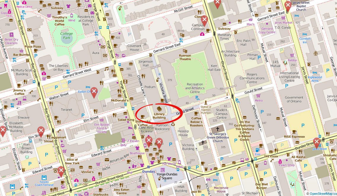
Location: Library Building, LIB-489, 4th Floor, 350 Victoria Street

For more of Geothink’s GIS Day coverage, see:

If you have thoughts or questions about this story, get in touch with Naomi Bloch, Geothink’s digital journalist, at naomi.bloch2@gmail.com.


GIS in the City: Toronto on the Map

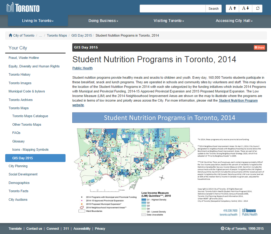
Map of Toronto school nutrition program distributionBy Naomi Bloch


This Wednesday, November 18, marks the 16th annual GIS Day. Throughout the week, Geothink will present a series of posts looking at some of the ways in which our collaborators, partners, and friends around the world are critically examining and using GIS as a tool for civic engagement and understanding.
The community snapshots presented this week highlight diverse perspectives and uses for GIS. 

If you make your way to Toronto’s City Hall on Wednesday, you’ll discover that the City is displaying a slideshow of some pretty interesting maps, just above the 3D model of the downtown core. The big-screen projection, set up for Geography Awareness Week and GIS Day, showcases some of the ways that Toronto’s municipal divisions are using GIS to tackle urban issues.

These same projects can also be perused at your leisure via a new City of Toronto GIS Day landing page. The City of Toronto is one of Geothink’s municipal partners.

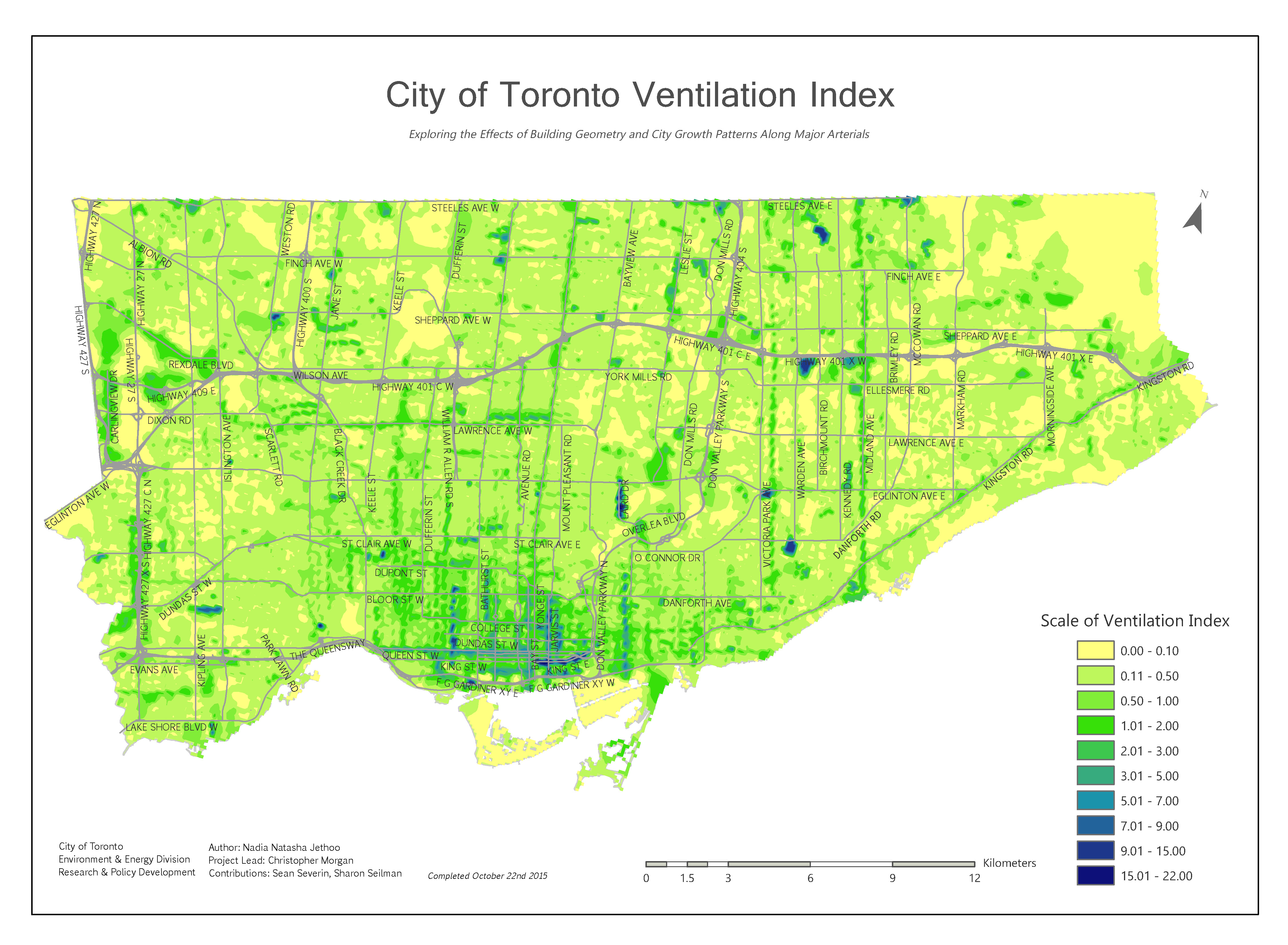
City of Toronto's Ventilation Index map. All images © City of Toronto 1998-2015. Used with permission.

City of Toronto’s Ventilation Index map. All images © City of Toronto 1998-2015. Used with permission.

The breadth of projects may surprise Toronto residents. Take the Environment and Energy Division’s (EED) Ventilation Index. The EED is mapping the city to get a full spatial understanding of areas known as “urban canyons,” narrow open spaces confined between built spaces that contribute to ground-level pollution — a problem most noticeable to pedestrians in the city. The higher the ventilation index, the greater the level of pollution. The Ventilation Index researchers’ goal is to try to identify “how the City’s changing building profile may have growing adverse effects at ground level and how to mitigate and adapt to the rapidly growing City.”

The City’s uses of GIS extend beyond urban planning or trying to understand how urban design impacts the environment. The Department of Public Health, for example, is employing GIS to better understand the distribution and funding of school nutrition programs. In 2014, 160,000 Toronto students participated in breakfast, snack and lunch programs, provided in schools and community sites throughout the city. Public Health has mapped the locations where student nutrition programs were in effect in 2014, with each site categorized based on the funding source behind the program. Incorporating census data such as the Low Income Measure, they’ve identified where meal programs are located relative to the City’s designated Neighbourhood Improvement Areas. This spatial mapping of school nutrition programs helps the City to understand which communities remain under-served and where additional funding should be allocated.

Want to know more about how the City of Toronto is using GIS? Head to Metro Hall on Friday, Nov. 20, anytime between 8:00 am and 3:00 pm. A few staff members from the City’s Geospatial Competency Centre will be on hand to answer questions.

For more of Geothink’s GIS Day coverage, see:

If you have thoughts or questions about this story, get in touch with Naomi Bloch, Geothink’s digital journalist, at naomi.bloch2@gmail.com.


Geothink Student Evan Hamilton Explores Canadian Municipal Open Data and the Role of Journalism

headshot of Evan Hamilton

Geothink student Evan Hamilton recently defended his master’s thesis on Toronto data journalists’ use of open data.

By Naomi Bloch

Data journalists are some of the most active users of government open data in Canada. In his recently defended thesis, Evan Hamilton, a master’s student in the University of Toronto’s Faculty of Information, examined the role of data journalists as advocates, users, and producers of open data.

Hamilton’s thesis, titled “Open for reporting: An exploration of open data and journalism in Canada,” addressed four research questions:

  1. Are open data programs in Ontario municipalities developing in a way that encourages effective business and community development opportunities?
  2. How and why do journalists integrate open data in reporting?
  3. What are the major challenges journalists encounter in gaining access to government data at the municipal level?
  4. How does journalism shape the open data development at both the policy level and the grassroots level within a municipality?

To inform his work, Hamilton conducted in-depth, semi-structured interviews with three key data journalists in the City of Toronto: Joel Eastwood at the Toronto Star, William Wolfe-Wylie at the CBC, and Patrick Cain at Global News. While open data is often touted as a powerful tool for fostering openness and transparency, in his paper Hamilton notes that there is always the risk that “the rhetoric around open data can also be employed to claim progress in public access, when in fact government-held information is becoming less accessible.”

In an interview with Geothink, Hamilton explained that the journalists made important distinctions between the information currently available on Canadian open data portals and the information they typically seek in order to develop compelling, public-interest news stories. “One of the big things I took away from my interviews was the differentiation that journalists made between Freedom of Information and open data,” said Hamilton. “They were using them for two completely different reasons. Ideally, they would love to have all that information available on open data portals, but the reality is that the portals are just not as robust as they could be right now. And a lot of that information does exist, but unfortunately journalists have to use Freedom of Information requests to get it, which is a process that can take a lot of time and not always lead to the best end result.”

Legal provisions at various levels of government allow Canadians to make special Freedom of Information requests to try to access public information that is not readily available by other means. A nominal fee is usually charged. In Toronto, government agencies generally need to respond to such requests within 30 days. Even so, government responses do not always result in the provision of usable data, and if journalists request large quantities of information, departments have the right to extend the 30-day response time. For journalists, a delay of even a few days can kill a story.

While the journalists Hamilton interviewed recognized that open data portals were limited by a lack of resources, there was also a prevailing opinion that many government agencies still prefer to vet and protect the most socially relevant data. “Some were very skeptical of the political decisions being made,” Hamilton said. “Like government departments are intentionally trying to prevent access to data on community organizations or data from police departments looking at crime statistics in specific areas, and so they’re not providing it because it’s a political agenda.”

Data that helps communities

In his thesis, Hamilton states that further research is needed to better understand the motivations behind government behaviours. A more nuanced explanation involves the differing cultures within specific municipal institutions. “The ones that you would expect to do well, do do well, like the City of Toronto’s Planning and Finance departments,” Hamilton said. “Both of them provide really fantastic data that’s really up-to-date, really useful and accessible. They have people you can talk to if you have questions about the data. So those departments have done a fantastic job. It’s just having all the other departments catch up has been a larger issue.”

An issue of less concern to the journalists Hamilton consulted is privacy. The City’s open data policy stresses a balance between appropriate privacy protection mechanisms and the timely release of information of public value. Hamilton noted that in Toronto, the type of information currently shared as open data poses little risk to individuals’ privacy. At the same time, the journalists he spoke with tended to view potentially high-risk information such as crime data as information for which public interest should outweigh privacy concerns.

Two of the three journalists stressed the potential for data-driven news stories to help readers better understand and address needs in their local communities. According to Hamilton’s thesis, “a significant factor that prevents this from happening at a robust level is the lack of data about marginalized communities within the City.”

The journalists’ on-the-ground perspective echoes the scholarly literature, Hamilton found. If diverse community voices are not involved in the development of open data policies and objectives, chances for government efforts to meet community needs are hampered. Because of their relative power, journalists do recognize themselves as representing community interests. “In terms of advocacy, the journalists identify themselves as open data advocates just because they have been the ones pushing the city for the release of data, trying to get things in a usable format, and creating standard processes,” Hamilton said. “They feel they have that kind of leverage, and they act as an intermediary between a lot of groups that don’t have the ability to get to the table during negotiations and policy development. So they’re advocating for their own interests, but as they fulfill that role they’re advocating for marginalized communities, local interest groups, and people who can’t get to the table.”

Policy recommendations

Hamilton’s research also pointed to ways in which data journalists can improve their own professional practices when creating and using open data. “There needs to be more of a conversation between journalists about what data journalism is and how you can use open data,” Hamilton said. “When I talked to them, there was not a thing like, ‘Any time you use a data set in your story you cite the data set or you provide a link to it.’ There’s no standard practice for that in the industry, which is problematic, because then they’re pulling numbers out of nowhere and they’re trusting that you’ll believe it. If you’re quoting from a data set you have to show exactly where you’re getting that information, just like you wouldn’t anonymize a source needlessly.”

While Hamilton concentrated on building a picture of journalists’ open data use in the City of Toronto, his findings resulted in several policy recommendations for government agencies more broadly. First, Hamilton stressed that “as a significant user group, journalists need to be consulted in a formal setting so that open data platforms can be better designed to target their specific needs.” This is necessary, according to Hamilton, in order to permit journalists to more effectively advocate on behalf of their local communities and those who may not have a voice.

Another recommendation is aimed at meeting the needs of open data users who have different levels of competency. Although he recognizes the challenges involved, in his concluding chapter Hamilton writes, “Municipal governments need to allocate more resources to open data programs if they are going to be able to fulfill the needs of both a developer class requiring technical specifications, and a general consumer class that requires tools (for example. visualizations and interactives) to consume the data.”

Finally, Hamilton recommends that municipalities engage in more formal efforts “to combat internal culture in municipal departments that are against publishing public information. Data should be viewed as a public service, and public data should be used in the public interest.”

If you have any questions for Evan, reach him on Twitter here: @evanhams


Evan Hamilton successfully defended his Master of Information thesis on September 29 at the Faculty of Information, University of Toronto. His work was supervised by Geothink co-applicant researcher Leslie Regan Shade, associate professor in the University of Toronto’s Faculty of Information. Other committee members included University of Toronto’s Brett Caraway and Alan Galey (chair), as well as April Lindgren, an associate professor at Ryerson University’s School of Journalism and founding director of the Ryerson Journalism Research Centre, a Geothink partner organization.

 Abstract

This thesis describes how open data and journalism have intersected within the Canadian context in a push for openness and transparency in government collected and produced data. Through a series of semi-structured interviews with Toronto-based data journalists, this thesis investigates how journalists use open data within the news production process, view themselves as open data advocates within the larger open data movement, and use data-driven journalism in an attempt to increase digital literacy and civic engagement within local communities. It will evaluate the challenges that journalists face in gathering government data through open data programs, and highlight the potential social and political pitfalls for the open data movement within Canada. The thesis concludes with policy recommendations to increase access to government held information and to promote the role of data journalism in a civic building capacity.

Reference: Hamilton, Evan. (2015). Open for reporting: An exploration of open data and journalism in Canada (MI thesis). University of Toronto.

If you have thoughts or questions about this article, get in touch with Naomi Bloch, Geothink’s digital journalist, at naomi.bloch2@gmail.com.

Geothoughts 7: Unpacking the Current and Future Value of Open Civic Data

Geothink researcher Peter Johnson and his students have been working with government partners across the country to examine the state of civic open data projects in Canada.

Geothink researcher Peter Johnson and his students have been working with government partners across the country to examine the state of civic open data projects in Canada.

By Naomi Bloch

Peter Johnson image

Peter Johnson, assistant professor in the University of Waterloo Department of Geography and Environmental Management, was recently awared Ontario’s Young Researcher Award.

Geothink co-applicant researcher Peter A. Johnson is an assistant professor of Geography and Environmental Management at the University of Waterloo. Johnson and his students have been working with Geothink government partners across the country to examine the state of civic open data projects in Canada. In our latest podcast, he discusses how the seemingly desirable ethos of open data may nonetheless hamper our understanding of how end users are interacting with government products.

In their July article published in Government Information Quarterly, Johnson and Geothink head Renee Sieber discuss what they see as the dominant models—and related challenges—of civic open data today. The authors suggest that these models may carry potentially conflicting motivations. Governments can distribute data and leave it to users to discover and determine data’s value, they may aim to track civic issues in ways that are cost efficient, or they may also try to support market innovation via data provision and the promotion of crowd-sourced contributions. On the other hand, open data efforts also have the potential to enable productive and empowering two-way civic interactions when motivated by non-economic imperatives.

What future directions will government data provision take? That may depend a lot on the choices that government agencies—and end users—make today.


If you have thoughts or questions about this podcast, get in touch with Naomi Bloch, Geothink’s digital journalist, at naomi.bloch2@gmail.com.

Reference
Sieber, R. E., & Johnson, P. A. (2015). Civic open data at a crossroads: Dominant models and current challenges, Government Information Quarterly, 32(3), pp. 308-315. doi:10.1016/j.giq.2015.05.003. OR: View pre-print copy.

Abstract
As open data becomes more widely provided by government, it is important to ask questions about the future possibilities and forms that government open data may take. We present four models of open data as they relate to changing relations between citizens and government. These models include; a status quo ‘data over the wall’ form of government data publishing, a form of ‘code exchange’, with government acting as an open data activist, open data as a civic issue tracker, and participatory open data. These models represent multiple end points that can be currently viewed from the unfolding landscape of government open data. We position open data at a crossroads, with significant concerns of the conflicting motivations driving open data, the shifting role of government as a service provider, and the fragile nature of open data within the government space. We emphasize that the future of open data will be driven by the negotiation of the ethical-economic tension that exists between provisioning governments, citizens, and private sector data users.