Tag Archives: augmented reality

Augmented Reality in Real Life: Evaluating the Potential of New Digital Tools for Use in Municipal Planning Practice

By: Laura Brown, Natalia Dmuchowska, Brodie Johnson, Teresa Liu, Corinna Prior, Matthew Zentner

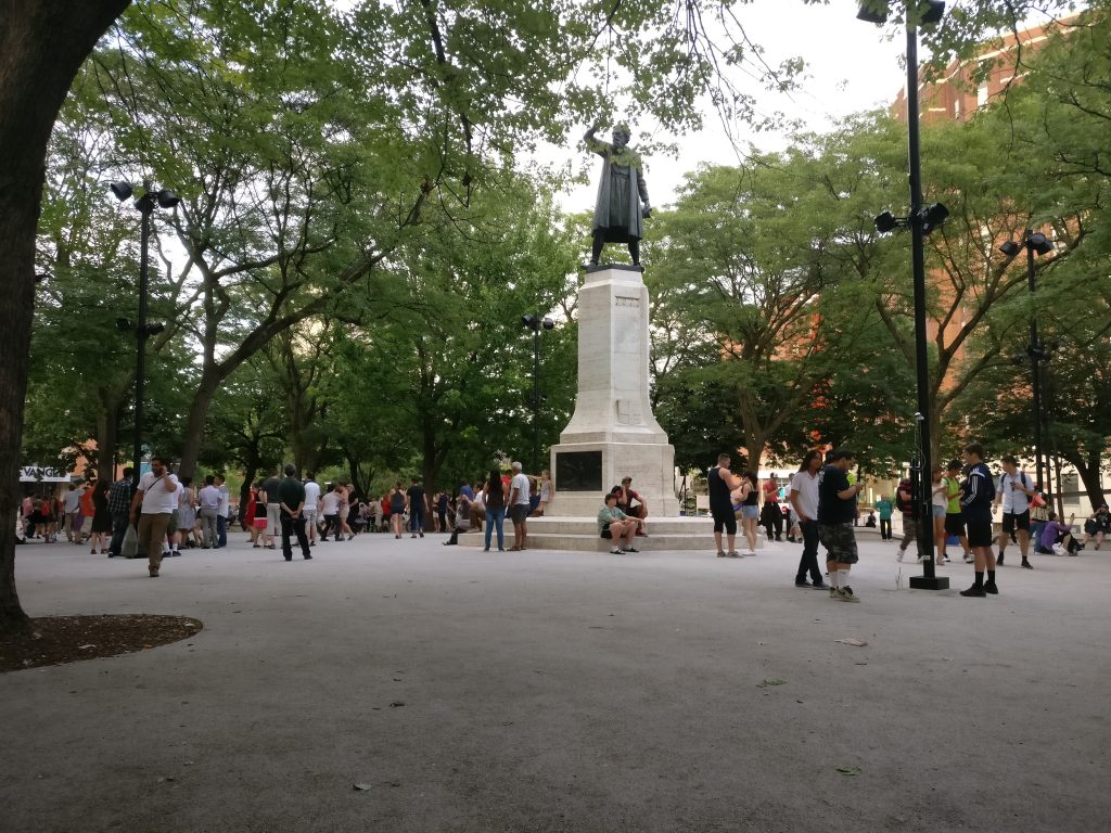
Pokémon Go was a phenomenon that swept the world this past summer. Cities around the globe experienced an influx of citizens into their public spaces as everyone tried to ‘catch-em-all.’ Crazed Pokémon trainers wandered the city swiping their phones and battling to win gyms, ultimately searching for the coveted Pikachu. The significance of these movements within the urban environment has been covered here.

The game is based on augmented reality (AR) technology that overlays a game world on top of a live map of the city, creating new ways for players to interact with the spaces around them. While other applications like Google Maps and Foursquare use similar technology, it was Pokémon GO that became the first game to achieve widespread success.

Over the last three months, a group of graduate researchers from the School of Urban and Regional Planning at Ryerson University also caught the PokéFever and sought to explore more serious aspects of the game. Working with clients from the City of Toronto Manager’s Office and Public Consultation Unit, their research investigates the challenges that municipalities face in working with new and emerging technologies and how urban planners might be able to use similar technology to consult and engage with the public. The potential of AR technology such as Pokémon GO to alter the behaviour of people in real space presents both opportunities to attract people to certain locations and animate space, as well as concerns regarding public safety and security, and inequities arising from disparities in access.

Pokémon GO Findings
Conducting an exploratory analysis into the relationship between game data and demographic data, the team first investigated the distribution of PokéStops and PokéGyms throughout Toronto. In the game, PokéStops are locations where players receive items necessary for gameplay, and players may join one of three teams and “battle” for possession of PokéGyms. For their research, however, the team was interested in these landmarks as fixed locations that draw players to visit them in the real world. In addition, the locations of these markers were selected based on the Google database as well as player suggestions from a previous AR game by the same developer called Ingress. According to the developer, the markers that were frequented most by Ingress players became Gyms in Pokémon GO, and the others became PokéStops.

While 90% of people within the city lived within a five-minute walk of game elements, access varies significantly in terms of density, disproportionately making the game play experience much richer in the downtown core. Whereas overcrowding in open spaces and parks became the focus of media attention, there was actually a much higher concentration of game elements along major corridors like Queen Street. Narrowing our boundaries to just the downtown core, however, did reveal higher concentrations of gyms and stops in open spaces. These results were surprising and suggest the different forms that the public realm takes across the city.

Figure 1. Indicators of concentrated play spaces in the City of Toronto, as represented by the fixed landmarks in Pokémon GO (PokéStops and Gyms)

Public Realm
As we moved through our analysis, something meaningful emerged. We started to think about Stops and Gyms as indicators of concentrated play spaces. The map below depicts what happens when you remove the road lines – clusters of dots begin to reflect desire paths into areas of the public realm that were appropriated for game play. Rather than simply revealing the distribution of the game throughout the urban fabric, the placement of the Stops and Gyms hint at the fine-grained spaces that interconnect more formal “Open Spaces” across the city. This may contribute to a more nuanced view of the public realm, in addition to the more obvious areas defined by parks and open spaces.

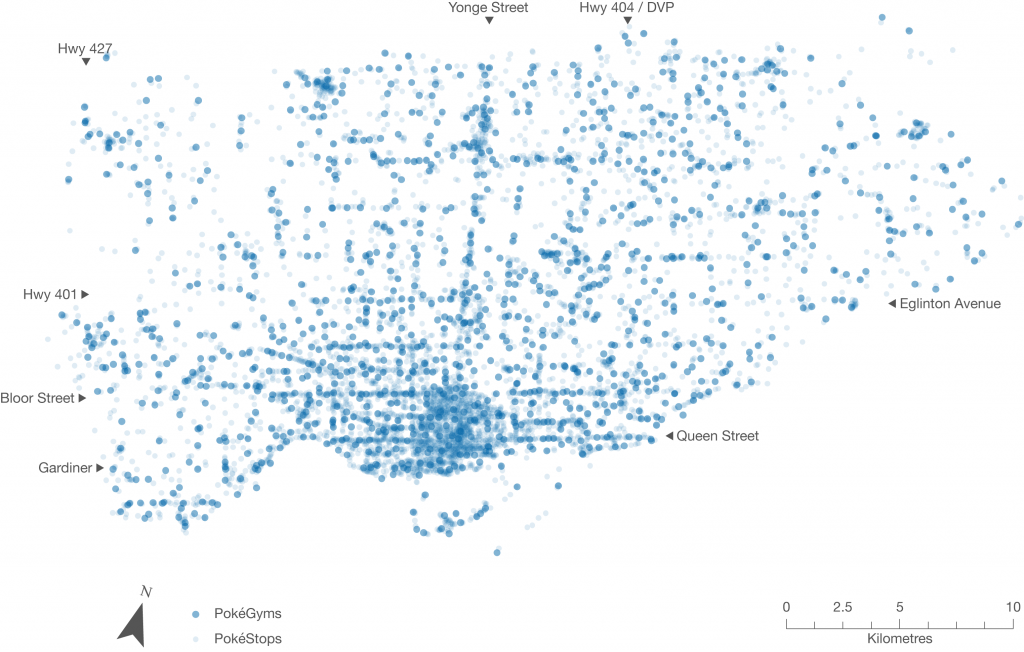
Figure 2. PokéStops and Gyms in the City of Toronto, without road lines

Because many of the Stop and Gym locations were user generated and determined on the basis of usage (based on Niantic’s previous AR game Ingress), they may serve as indicators of where players might want to linger and occupy the public realm, as well as landmarks that hold cultural significance. While we recognize that this data only reflects a segment of the public, we think it might be possible for city planners to use this data in their analyses of streetscapes and cultural heritage, to better visualize existing public assets. Further it provides insight into how citizens use spaces in the city.

Augmented Reality and Planning
Current public consultation and engagement practices with citizens and stakeholders are predicated on in-person interaction, although they are increasingly occurring through online and other platforms. AR technology can draw people to new spaces and change the way they move around the city. Harnessing AR could bring new opportunities for reaching different demographics in the places where they live, work, and play.

We looked at the potential of using augmented reality technology to enhance development proposal signs through geo-location and visualization. Imagine walking down a street and receiving a notification on your smartphone for a nearby development proposal. By clicking it on it, the user is guided to the location where they are shown a visualization of the project conveniently through their phone. This would provide more meaningful information about the size and scale of the project, allowing people to see the full extent of the proposal in human scale and in context, while reviewing specific details right then and there.

Figure 3. Application of AR technology for visualization of a development project. Source: Augment

Finally, augmented reality can be used as a platform for public education and collaboration between community groups to enhance heritage planning and the public realm. This could potentially transform the whole city into a new type of living museum without borders, inspiring people to feel greater ownership over the city and its heritage.

Evaluating Technology for Planning
It is also necessary to understand how emerging technologies are created, implemented, and used. We have created an evaluative framework that explores the different areas planners must be aware of when evaluating new technology, an overview of which is shown in the figure below. These include the technical aspects and requirements (such as the platform of the technology), opportunities for greater engagement (ways to break down barriers like language and visual or auditory impairment), and potential inequalities and liabilities (such as data security concerns and differing abilities to access technology). Most importantly, this assessment allows planners to determine the usefulness of a technology in their daily planning practice.

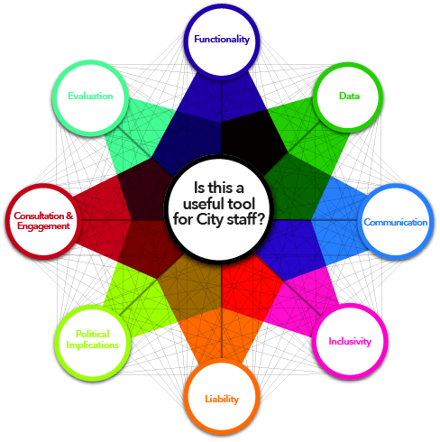
Figure 4. Evaluative framework for planners for examining new technologies

The continually changing world of technology creates new opportunities that have the potential to enhance the way people interact with their city and the processes that govern it. We feel that planners are well placed to harness these emerging technologies to augment their cities in real life.

Although the Pokémon craze has since died down, it provided us with a unique opportunity to discover the potential of emerging technologies. We look forward to seeing what the future has in store for cities and for urban planners.

The full evaluative framework and results from the Pokémon GO analysis will be posted to the Geothink website shortly.

For more information please feel free to contact us at teampokeplan@gmail.com. Team PokéPlan is comprised of Laura Brown, Natalia Dmuchowska, Brodie Johnson, Teresa Liu, Corinna Prior and Matthew Zentner.

Thank you to our supervisor and Geothink co-applicant Dr. Pamela Robinson (Ryerson University, School of Urban and Regional Planning) and our clients at the City of Toronto!

Potentials and Pitfalls of Civic Engagement through Pokémon GO, Augmented Reality, and Gamification

By Peck Sangiambut

Media coverage in recent months may be focusing on Niantic’s continuous battle with Pokémon GO exploits and the game’s apparent demise, but here at Geothink we still see great potential in augmented reality (AR) games to promote community engagement. Our research examines communities and citizen-government engagement, particularly through geospatial technologies such as the geoweb. At the height of the craze, Pokémon GO resulted in conspicuous movements of people through engagement with a location-based service. This provides us with a convenient case study of the potential effects of a location-based service that causes movement of people through gamification. Geothink has also investigated gamification in urban planning and citizen engagement through platforms such as Minecraft and the precursor to Pokémon GO, Ingress. A recent publication from Geothink student, Lisa Mather Ward, and her supervisor, Dr. Pamela Robinson, has looked at Minecraft’s potential for public consultation.

Pokémon GO and Geography

Geothink co-applicant Dr. Claus Rinner (Ryerson University, Department of Geography and Environmental Studies) has written a post introducing geographic analysis concepts with Pokémon GO. In it, he writes about geographic distribution, catchment areas, and links them to geospatial analysis methods such as buffering, distance decay, and suitability mapping. Some of the built-in distributions of Pokémon (such as having certain types of Pokémon available for certain types of terrain, weather, continents, and time of day) are similar to what we look for in ecological species distribution. The same concepts and techniques are widely used by corporations conducting market research, retail analysis, and location intelligence. As such, Pokémon Go is a great way to introduce basic geographic concepts to students and the interested public.

A Medium for Contestation of Urban Places?

Movements of people that are a direct result of their interaction with a mobile app could result in new contestations of space and place. Pokémon GO is potentially one tool that influences and reassigns cultural identity and platial meaning. In downtown Montreal, we have seen a regular congregation of Pokémon trainers develop around Cabot Square to catch Pokémon, level up, and wrestle for control over its gym. Will this new influx of people change the identity of Cabot Square? Or has this already happened?

Pokémon Go (right) versus swing dancing (left) - is location-based gaming a new tool to contest space and place? Photo credit: Suthee Sangiambut

Pokémon Go (right) versus swing dancing (left) – is location-based gaming a new tool for contesting space and place? Photo credit: Suthee Sangiambut

Geothink Head, Dr. Renee Sieber (McGill University, Department of Geography and School of Environment), has spoken of the potential abuses or biases that may result from the placement of Pokémon and pokéstops on the map. Algorithms are the determinant for a pokéstop and Pokémon spawn locations. However, as Sieber emphasises, technology itself should never be assumed to be neutral. Implicit biases may be injected by programmers, managers of the technology, and the underlying data. For example, it has been noted that certain neighbourhoods are poorer in pokéstops, potentially due to the distribution biases in crowdsourced contributions that formed a part of the underlying pokéstop dataset.

On the other hand, does location-based gaming have the potential for real-world community building? Are players actually exploring their own communities?

Geothink co-applicant Dr. Stéphane Roche (Université Laval, Département des sciences géomatiques) and his PhD student, Territutea Quesnot have studied landmarks and wayfinding, particularly through social networks with gamified interactions such as FourSquare. As Roche notes, the concept of ‘checking in’ to a location is not new. Pokémon GO’s uniqueness is in its content and in overlaying the Pokémon universe over the real world (such as through the camera feature) with more integration than Ingress. For Roche, such movements of people could also be a form of contestation or appropriation of places. He defines an urban place as “an equation between a physical location, an event, and the name associated with the phenomenon”. Landmarks in the city can therefore have multiple ‘places’ depending on their usage. For example, a pond has one use during the summer, but turns into an ice skating rink during the winter. Pokémon GO, Roche says, “has created new urban places, in a location where existing places were already there”. Roche cautions us to not immediately condemn the phenomenon of Pokémon GO players congregating in large groups, as contestation and appropriation of urban places is not a new process. Pokémon GO itself has not had an entirely negative effect on urban environments and has been attributed as a factor in revitalising the Brussels community after this year’s terrorist attacks.

Roche is optimistic that “gamification and technology has the potential to improve our understanding of the world, improve our skills, including spatial skills, and could help people to discover new components of the world”, but also echoes Sieber’s concerns over algorithmic regulation where, “because of the choices that are embedded in the code and algorithms, there is a kind of orientation and social classification…and it becomes more and more difficult to discover new things”.

For Rinner, government should not have to resort to gamification to promote community engagement or citizen-government interaction, but he admits,

“I am afraid that it will soon be necessary to get anyone to do anything good. So, yes, I expect that government will soon use gamification to motivate people to engage in planning questions or politics. And more concerningly, I expect that businesses will use geolocation games to steer people to the right, or maybe wrong, places.”

AR and Gamification: Potential for Civic Engagement in Urban Planning

Regardless of Pokémon GO’s success, Geothink is looking to investigate the potential of AR in promoting civic engagement at the municipal level. Geothink co-applicant Dr. Pamela Robinson (Ryerson University, School of Urban and Regional Planning) has brought together a group of six masters’ of urban planning graduate students to investigate AR’s potential for the City of Toronto. Their mission is:

To explore the potential of AR technology in relation to public consultation & civic engagement by local governments and to provide a framework for analyzing future engagement opportunities

According to the students, AR has a high potential due to its fusing of the digital and physical. Unlike Virtual Reality (VR), AR does not completely remove the physical world and users can still interact with each other face-to-face, rather than being restricted to a virtual environment.

Currently at a preliminary stage of their project, the students have investigated the distribution of pokéstops and urban accessibility to pokéstops to examine the geographic reach of the game in the city. The density and location of check-in locations for any gamified service are crucial when attempting to attract people to a particular location, such as the location of a public consultation or town hall meeting and also important for evaluating how inclusive the tool can be in terms of reaching residents. The students discovered that a player’s experiences of Pokémon GO can really differ depending on where they live in Toronto.

Team PokéPlan (as they have named themselves) is also looking at other issues that a municipality will be concerned with, such as legal considerations (privacy, liability), language barriers, issues of service coverage and accessibility (the digital divide), and how to reach broad and target audiences, and finally gamification. According to Geothink student Corinna Prior, the City of Toronto has already begun to experiment with more flexible types of consultation such as the Planners in Public Spaces programme where planners go to the people. For Prior, “gamification is a really powerful tool. The potential to get people out and about is really powerful”. If AR and gamification could be used to support public consultation processes, we may experience radical changes in how citizens interact with their municipal governments.

More updates on TeamPokéPlan once their project ramps up. In November, Team PokéPlan will host a World Town Planning Day breakfast (November 8th), be the guest speakers at Civic Tech Toronto’s Hack Night (November 15th) and present their final report on November 22nd. For more information about their work please contact Pamela Robinson.