Geothink Video Interview 1: Teresa Scassa, University of Ottawa

By Drew Bushfaculty_olympics

This Geothink Video Interview brings us a closeup look at the work and ideas of Teresa Scassa, Canada Research Chair in Information Law at the University of Ottawa. In particular, we talk with her about her views on Canada’s Action Plan for Open Government 2.0, problems with open access under the plan, the idea of making government data open by default and the role of academics (like those in Geothink) in making government more transparent.

Find the interview below. As always, all thoughts and comments are welcome. And, of course, stay tuned for more videos and podcasts soon on Geothink.ca.

If you have thoughts or questions about the video, get in touch with Drew Bush, Geothink’s digital journalist, at drew.bush@mail.mcgill.ca.

An Emergent Field: Making Better Maps By Applying Geographical Science to the Human Brain

e3abbecd4

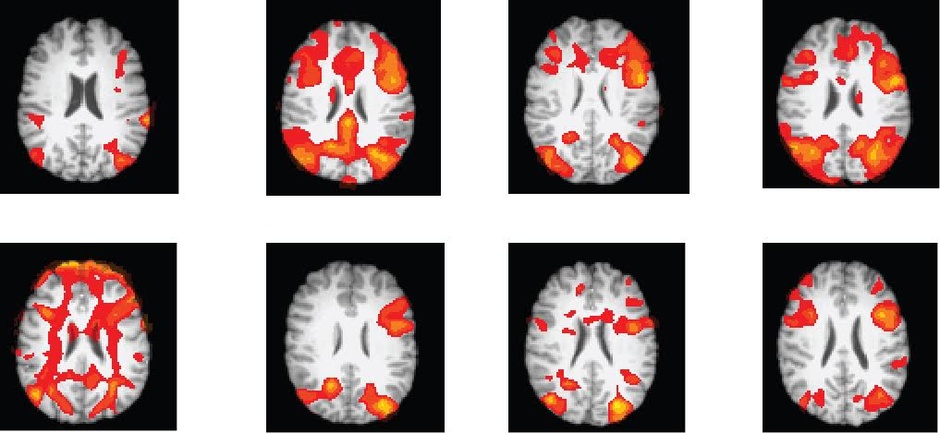
Monitoring the human brain. (Photo courtesy of Flickr user Tabsinthe)

By Drew Bush

City planners often use socioeconomic data collected in surveys to determine neighbourhoods that might benefit from improved services. Yet such types of data can have a significant margin of error, especially when they’re collected from a relatively small group.

“Especially if you want to look at a small subset of the population—say, kids under 5 who are living in poverty—the uncertainty level is just huge,” Amy Griffin, a senior lecturer in the School of Physical, Environmental, and Mathematical Sciences at Australia’s University of New South Wales told CityLab’s Laura Bliss last November. “A lot of times, people are making decisions based on highly uncertain census data.”

Her research looks at how different kinds of visualizations can affect decision-making, with an emphasis on understanding the cognitive processes behind the use of maps. Still others in her field are engaged in understanding how the human brain engages with maps in order to improve map-making and the role it plays in municipal governance.

Some in the field study neuroscience from the uniquely geographical perspective of how the human brain reacts to maps with differing standards, visual cues and rules. Sara Irina Fabrikant, head of the Geography Department at the University of Zurich, dedicates her time to understanding how users make inferences from the design elements on a map, and how mapmakers might then design maps that convey data more clearly.

For example, in experiments she conducted to compare a NOAA (National Oceanic and Atmospheric Administration) mass-media weather map versus one of her own design, she found design elements could be used to simplify confusing variables and help users better understand characteristics like wind pressure. Her map included well-defined contour lines for wind pressure and less emphasis on temperature colors.

“Are our rules really good ones?” Fabrikant told CityLab. “If so, how? If they’re not, how can we improve them?”

Amy Lobben, head of the Department of Geography at the University of Oregon, asks a different question. She wants to know what neurological processes are at play as individual brains perform map-related tasks. Her possible goal: to create a map that plays off a given person’s cognitive strengths and weaknesses.

“You could potentially design a map that works with individuals’ innate abilities,” she told CityLab.

If you have thoughts or questions about the article, get in touch with Drew Bush, Geothink’s digital journalist, at drew.bush@mail.mcgill.ca.

Open Data Gets Boost from Obama’s 2016 Budget Proposal

obama-budget-plan

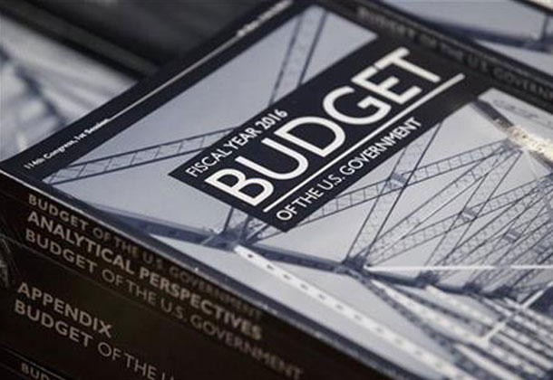
Obama’s 2016 federal budget proposal (Photo courtesy of www.philstar.com).

By Drew Bush

Lost in the details of a $4 trillion budget plan proposed by U.S. President Barack Obama are several provisions that seek to increase public access to government data, strengthen government analysis and collection of data and improve data-driven government decision-making, according to a story first reported in the Federal Times.

Released on February 2, Obama’s proposed 2016 budget for the federal government will likely meet strong resistance from a Republican controlled Congress. However, of more interest to the Geothink audience is the administration’s continuing support for programs which help collect, analyze and share the petabytes of data which the U.S. Government collects each day

“The administration is committed to continuing cost-effective investment in federal statistical programs in order to build and support agencies’ capacity to incorporate evidence and evaluation analyses into budget, management and policy decisions,” the budget reads. “The 2016 budget includes a package of proposals that would make additional administrative data from federal agencies and programs legally and practically available for policy development, program evaluation, performance measurement and accountability and transparency efforts.”

In terms of numbers, the proposed budget would increase funding for statistical programs by 2.5 percent, from $4.2 billion in 2015 to $5.2 billion in 2016. One of the largest shares would go to the U.S. Census Bureau which would receive $10 million to continue building out its collection of datasets and the infrastructure that allows users to collate, analyze and share data.

The funding would also help the federal government acquire state and municipal datasets that could then become accessible to the public. Furthermore, an additional $2 million would raise the General Service Administration’s E-Government initiative to $16 million. This program seeks to “develop and provides direction in the use of Internet-based technologies to make it easier for citizens and businesses to interact with the Federal Government, save taxpayer dollars, and streamline citizen participation.”

The administration has also supported the creation of a legislative commission proposed by Rep. Paul Ryan, R-Wisc., and Sen. Patty Murray, D-Wash., to examine ways to use government data to improve federal operations and support private research and industry.

If you have thoughts or questions about the article, get in touch with Drew Bush, Geothink’s digital journalist, at drew.bush@mail.mcgill.ca.

Spotlight on Recent Publications: Teresa Scassa at the Intersection of Intellectual Property Rights and Municipal Transit Data

By Drew Bush

faculty_olympics

Teresa Scassa is Canada Research Chair in Information Law at the University of Ottawa.

This story was originally reported on Teressa Scassa’s personal blog which you can find here.

In a paper just published in the Fordham Urban Law Journal, Geothink researcher Teresa Scassa argues that the actual laws governing intellectual property (IP) rights are often surprisingly irrelevant in disputes over rights to municipal transit data. Instead, she finds that being in a position to make a claim to IP rights is often more important than actually having a good claim.

“How people decide to interact with each other is more important than what their precise legal rights might be,” Scassa, the Canada research chair in information law at University of Ottawa, wrote in an e-mail to Geothink.ca. “Often, to understand the precise boundaries of those rights it is necessary to litigate and one or both parties may lack the resources to go to court. So, in those circumstances, parties may reach an understanding of how they will set the boundaries of their relationships.”

Her paper, entitled Public Transit Data Through an Intellectual Property Lens: Lessons About Open Data, examines some of the challenges presented by the transition from ‘closed’ to open data within the municipal context. She completed the paper as part of a Geothink project examining open data in a concrete context that’s particular to municipalities.

“In the municipal transit data context, there was generally an imbalance of resources between developers and municipalities, and there was little desire on either part to go to court,” she added. “Nevertheless, in the early days, municipal transit authorities asserted their IP rights using cease and desist letters. This assertion of IP rights was met with arguments about the need for open data, and eventually compromises were reached around open data that shifted over time, and varied from one municipality to another.”

In the paper, she examines how these legal developments have impacted the use of real-time transit data by developers seeking to make use of this data in digital applications and corporations hoping to add value to products and services they offer. In particular, the paper covers three types of data: 1) Route maps; 2) Static data (such as bus timetables that only change seasonally); 3) And, real-time GPS data generated by units installed on transit vehicles.

A number of municipalities exerted their IP rights over such data because of concerns that ranged from ensuring its quality and authenticity to preserving the ability to make data available on a cost-recovery basis.

“The emerging open data movement shifted some of these concerns and created a new set of expectations and practices around open municipal transit data,” she wrote in her e-mail. “As data become more complex (with the advent of real-time GPS data, for example) the IP issues shifted and changed again, raising new questions about open data in this context. This is where the next phase of my research will take me.”

To find out more about Teresa Scassa’s work, visit her personal blog here or follow her on Twitter @teresascassa. For more on IP, check out another of her recent papers (written with Univeristy of Ottawa doctoral student Haewon Chung) that analyzes various types of volunteer citizen science activities to determine whether they raise legal questions about IP ownership.

Find a link to the article along with its abstract below.

Public Transit Data Through an Intellectual Property Lens: Lessons About Open Data

This paper examines some of the challenges presented by the transition from ‘closed’ to open data within the municipal context, using municipal transit data as a case study. The particular lens through which this paper examines these challenges is intellectual property law. In a ‘closed data’ system, intellectual property law is an important means by which legal control over data is asserted by governments and their agencies. In an ‘open data’ context, the freedom to use and distribute content is a freedom from IP constraints. The evolution of approaches to open municipal transit data offers some interesting examples of the role played by intellectual property at every stage in the evolution of open municipal transit data, and it highlights not just the relationship between municipalities and their residents, but also the complex relationships between municipalities, residents, and private sector service providers.

If you have thoughts or questions about the article, get in touch with Drew Bush, Geothink’s digital journalist, at drew.bush@mail.mcgill.ca.

Tracey P. Lauriault on Citizen Engagement (or lack thereof) with Canada’s Action Plan on Open Government 2.0

tlauriault312

Tracey is a Postdoctoral Researcher in the new field of Critical Data Studies.

By Drew Bush

More than 1,450 individuals collectively generated 2,010 ideas, comments and questions for the Canadian Government on its Action Plan for Open Government 2.0. But one researcher with The Programmable City project who studies open data and open government in Canada feels these numbers miss the real story.

The process leading up to the “What We Heard” report, issued after the completion of consultations from April 24–October 20, 2014, only reflected the enthusiasm of the open data programming community, she says. A broader engagement with civil society organizations that most need help from the government to accomplish their work was severely lacking.

“They might be really good at making an app and taking near real time transit data and coming up with a beautiful app with a fantastic algorithm that will tell you within the millisecond how fast the bus is coming,” Tracy Lauriault, a postdoctoral researcher at the National Institute for Regional and Spatial Analysis (NIRSA), said. “But those aren’t the same people who will sit at a transit committee meeting.”

She believes the government has failed to continue to include important civil society groups in discussions of the plan. Those left out have included community-based organizations, cities having urban planning debates, anti-poverty groups, transportation planning boards and environmental groups. She’s personally tried to include organizations such as the Canadian Council on Social Development or the Federation of Canadian Municipalities only to have their opinions become lost in the process.

“There is I think a sincere wish to collect information from the people who attend but then that’s it,” she said.  “There is no follow up with some people or the comments that are made—or even an assessment, a careful assessment, of who’s in the room and what they’re saying.”

“I’m generally disappointed in what I see in most of these documents,” she added. “When they were delivering or working towards open data back in 2004, 2005 it was really about democratic deliberation and evidenced-informed decision-making—making sure citizens and civil society groups could debate on par with the same types of resources government officials had.”

For it’s part, the government notes that 18 percent of the participants came from civil society groups. But such groups were really just ad-hoc groups who advocate for data or are otherwise involved in aspects of new technology, according to Lauriault. Such input, while useful, is usually limited to requests on datasets, ranking what kind of dataset you’d like to see or choosing what platforms to use to view it, she added.

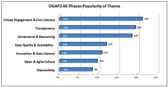
The report itself notes comments came from the Advisory Panel on Open Government, online forums, in-person sessions, email submissions, Twitter (hash tag #OGAP2), and LinkedIn. In general, participants requested quicker, easier, and more meaningful access to their government, and a desire to be involved in government decision making beyond consultations.

Some suggested that the Government of Canada could go even further toward improving transparency in the extractives sector. For example, proposed legislation to establish mandatory reporting standards could stipulate that extractives data be disclosed in open, machine-readable formats based on a standard template with uniform definitions.

figure5-eng

Major themes to emerge from citizen comments on the “What We Heard Report” (Image courtesy of the Government of Canada).

Find out more about this figure or the “What We Heard” report here.

If you have thoughts or questions about the article, get in touch with Drew Bush, Geothink’s digital journalist, at drew.bush@mail.mcgill.ca.

Spotlight on Recent Publications: Interrogating the Nature of Geosocial Data with Stéphane Roche

BEACONS

London Olympic wayfinding beacon (Photo courtesy of www.mudarchitecture.com).

By Drew Bush

In two articles published this January, Geothink researcher Stéphane Roche and his doctoral student Teriitutea Quesnot argue that not all geosocial data is equivalent, and that better data on the social significance of a landmark could greatly enhance our understanding of human wayfinding behavior. A Professor of Geomatics at University of Laval, Roche’s research over the past five years has focused on how new forms of digital spatiality affect spatial reasoning skills, and the capacity of individuals to engage in the city.

Entitled “Measure of Landmark Semantic Salience through Geosocial Data Streams,” the first paper was published by Roche in the ISPRS International Journal of Geo-Information. The authors write that a lot of research “in wayfinding is done in order to enable individuals to reach as quickly as possible a desired destination, to help people with disabilities by designing cognitively appropriate orientation signs, and reduce the fact of being lost.”

Previous researchers in the field of geo-cognition have tried to characterize the salience of landmarks in human wayfinding behaviour. Most have classified differing landmarks by visual, structural and semantic cues. However, the social dimensions of a landmark, such as how they are practised or recognized by individuals or groups, had been excluded from its semantic salience (or often reduced to historical or cultural cues), according to the authors.

Instead, the authors follow in a tradition of research which utilizes text mining from the web to understand how places are expressed by Internet users rather than relying on how they are visually perceived. Such an approach has been made possible by social media and mobile communications technology that has resulted in vast user-generated databases that constitute “the most appropriate VGI data for the detection of global semantic landmarks.”

In conducting their research, the authors examined world famous landmarks and detected semantic landmarks in the cities of Vienna and Paris using data from Foursquare API v2 and Facebook API v2.1. from September 29, 2014 to November 15, 2014.

In a second paper entitled “Platial or Locational Data? Toward the Characterization of Social Location Sharing,” the authors expanded on this theme in arguing that not all geosocial data is equal. The paper was presented at 48th Hawaii International Conference on Systems Sciences this past January.

Some data, which the authors consider “platial,” relates more to users experiences of a given place while “spatial” data is tied to the actual coordinates of a place. In the context of geosocial data, spatial data might mean the exact location of the Eiffel tower while palatial could refer to a person passing by the Eiffel tower or taking a photo of it from another location.

Because each can potentially represent a very different kind of data point, they must be treated differently. As the authors write, “With the objective of a better understanding of urban dynamics, lots of research projects focused on the combination of geosocial data harvested from different social media platforms. Those analyses were mainly realized on a traditional GIS, which is a tool that does not take into account the platial component of spatial data. Yet, with the advent of Social Location Sharing, the inconvenience of relying on a classic GIS is that a large part of VGI is now more palatial than locational.”

Find links to each article along with their abstracts below.

Measure of Landmark Semantic Salience through Geosocial Data Streams

ABSTRACT

Research in the area of spatial cognition demonstrated that references to landmarks are essential in the communication and the interpretation of wayfinding instructions for human being. In order to detect landmarks, a model for the assessment of their salience has been previously developed by Raubal and Winter. According to their model, landmark salience is divided into three categories: visual, structural, and semantic. Several solutions have been proposed to automatically detect landmarks on the basis of these categories. Due to a lack of relevant data, semantic salience has been frequently reduced to objects’ historical and cultural significance. Social dimension (i.e., the way an object is practiced and recognized by a person or a group of people) is systematically excluded from the measure of landmark semantic salience even though it represents an important component. Since the advent of mobile Internet and smartphones, the production of geolocated content from social web platforms—also described as geosocial data—became commonplace. Actually, these data allow us to have a better understanding of the local geographic knowledge. Therefore, we argue that geosocial data, especially Social Location Sharing datasets, represent a reliable source of information to precisely measure landmark semantic salience in urban area.

Platial or Locational Data? Toward the Characterization of Social Location Sharing

ABSTRACT

Sharing “location” information on social media became commonplace since the advent of smartphones. Location-based social networks introduced a derivative form of Volunteered Geographic Information (VGI) known as Social Location Sharing (SLS). It consists of claiming “I am/was at that Place”. Since SLS represents a singular form of place-based (i.e. platial) communication, we argue that SLS data are more platial than locational. According to our data classification of VGI, locational data (e.g. a geotagged tweet which geographic dimension is limited to its coordinate information) are a reduced form of platial data (e.g. a Swarm check-in). Therefore, we believe these two kinds of data should not be analyzed on the same spatial level. This distinction needs to be clarified because a large part of geosocial data (i.e. spatial data published from social media) tends to be analyzed on the basis of a locational equivalence and not on a platial one.

If you have thoughts or questions about the article, get in touch with Drew Bush, Geothink’s digital journalist, at drew.bush@mail.mcgill.ca.

#Geothink Chat Transcript, 20 January 2015

Twitter Chat on #IntellectualProperty, #copyright, and #geodata, hosted by Cheryl Power, PhD student at UOttawa’s Faculty of Law.

Cross-posted from Mapping Mashups.


@geothinkca Jan 20, 2:59pm Welcome all to our #geothink chat, hosted by @cheryldpower on #IntellectualProperty, #copyright, and #geodata! Thanks for joining us!
@cheryldpower Jan 20, 3:00pm Good evening everyone, Cheryl speaking – Let’s hear from the audience who is out there tonight? #geothink #cheryldpower
@mappingmashups Jan 20, 3:00pm Today on #geowebchat we’re joining a chat organized by @geothinkca. Use the hashtag #geothink instead! #geowebchat will be back in 2 weeks.
@re_sieber Jan 20, 3:02pm Can we copyright a geodataset? My understanding is no in US; yes in Canada #geothink
@notgregorypeck Jan 20, 3:02pm #geothink hello all. looking frwrd to discussion with @cheryldpower
@mappingmashups Jan 20, 3:02pm @cheryldpower Hi Cheryl. I work at @stamen making maps with #opendata/#openstreetmap. Also doing a PhD at UBC. #geothink
@AmrEldib Jan 20, 3:03pm @cheryldpower hey, Cheryl. I’m Amr in Vancouver, and wanted to hear all about @geothinkca and #geothink
@cheryldpower Jan 20, 3:04pm @re_sieber #geothink See feist *US
@mappingmashups Jan 20, 3:04pm @cheryldpower I also run #geowebchat… hoping the regular #geoweb audience joins this #geothink chat.
@AmrEldib Jan 20, 3:04pm @re_sieber wouldn’t think be like copyrighting an API which is the topic of dispute between Oracle and Google #geothink
@mappingmashups Jan 20, 3:05pm @cheryldpower We’ve done a few #geowebchats about #opendata. Check out our transcripts after this #geothink chat: mappingmashups.net/geowebchat/
@re_sieber Jan 20, 3:07pm .@cheryldpower I know ab Feist, although it leaves copyright door open for more complicated db structures #geothink
@mhaklay Jan 20, 3:08pm Will it be interesting to explore ODBl opendatacommons.org/licenses/odbl/ for this #geothink discussion?
@JamesLMilner Jan 20, 3:08pm Tuning in to #geothink ; not to hot on IP and copyright but know a little about open source licenses
@cheryldpower Jan 20, 3:09pm @re_sieber #geothink Science technology and IP & Innovation for 10 years !!
@re_sieber Jan 20, 3:09pm @AmrEldib Here’s EFF on copyright case ab copyrighting APIs eff.org/press/releases… #geothink
@cheryldpower Jan 20, 3:10pm @re_sieber #geothink Is it an original selection of data discuss?
@notgregorypeck Jan 20, 3:10pm #geothink can you copyright dataset – according 2 interview with David Fewer, hving a dbase isn’t enough for copyright in CanPost case
@re_sieber Jan 20, 3:12pm Also hot in Canada, copyright case of Canada post v @geolytica cbc.ca/news/technolog… #geothink
@notgregorypeck Jan 20, 3:12pm #geothink intrview with David Fewer – one essential ingrdient for copyright: skill of judgement in selection and arrangement of data
@TenilleEBrown Jan 20, 3:14pm @notgregorypeck Do you have a link for that interview Peck? #geothink
@re_sieber Jan 20, 3:15pm .@notgregorypeck Big diff btwn Canada & US in terms of “sweat of brow” vv copyright #geothink
@re_sieber Jan 20, 3:16pm .@notgregorypeck In Canada, you can count some “sweat of brow” as well as creativity in asserting copyright #geothink
@JamesLMilner Jan 20, 3:16pm ODBI license looks solid but could be more clear about commercial use as per tldrlegal.com is about Apache 2.0, MIT etc #geothink
@geothinkca Jan 20, 3:16pm @TenilleEBrown Here is the link to the #Geothink newsletter, the interview is on page 12!
@cheryldpower Jan 20, 3:17pm Have you been exposed to any type of licensing in association with your research project? #geothink #cheryldpower
@notgregorypeck Jan 20, 3:18pm #geothink CIPPIC, in Geolytica case, are arguing about that disctntion on ‘sweat of brow’. not easy to determine when everything is sftwre
@geothinkca Jan 20, 3:19pm @TenilleEBrown geothink.ca/geothink-newsl… #geothink
@mappingmashups Jan 20, 3:19pm @JamesLMilner Yes, #ODbL was meant to clear up a lot of the commercial use cases for #OSM, but many think it’s still not obvious. #geothink
@cheryldpower Jan 20, 3:19pm @JamesLMilner #geothink Do you have a link?
@ClausRinner Jan 20, 3:20pm Re @re_sieber : What do people think/know about postcodes in OpenStreetMap? Seems a great platform to collect them systematically. #geothink
@cheryldpower Jan 20, 3:21pm @mhaklay #geothink Do you have specific questions? Have you experience with the license?
@re_sieber Jan 20, 3:21pm Copyright in geospatial realm draws on precedence of both pictures (maps), easier to copyright, v. data, difficult to copyright #geothink
@JamesLMilner Jan 20, 3:23pm @mappingmashups interesting. Just read this article about #ODbL issues openstreetmap.org/user/lxbarth/d… #geothink
@mhaklay Jan 20, 3:23pm @cheryldpower No, I don’t have any specific question. Just noticed that it created a lot of noise from different directions! #geothink
@re_sieber Jan 20, 3:23pm .@ClausRinner @geolytica case show us Canada Post asserts copyright over 6 digit postal codes, regardless of collection platform #geothink
@cheryldpower Jan 20, 3:25pm @re_sieber #geothink Tele-Direct v. American Business Information, need original intellectual creation
@re_sieber Jan 20, 3:25pm .@ClausRinner What can be done legally in US vv copyright can’t nec be done legally in Canada. Prob for intl platform lk #OSM #geothink
@mhaklay Jan 20, 3:25pm @cheryldpower e.g. lists.openstreetmap.org/pipermail/lega… or openstreetmap.org/user/lxbarth/d… #geothink vs osmfoundation.org/wiki/License #geothink
@re_sieber Jan 20, 3:28pm .@cheryldpower Tele-Direct case still asserted that min degree of skill in arrangement is protected by copyright under Canada law #geothink
@mappingmashups Jan 20, 3:29pm @ClausRinner @re_sieber Related to postal codes in #OSM is the openaddresses.io project which is a parallel database w/out #ODbL #geothink
@re_sieber Jan 20, 3:30pm .@cheryldpower’s mention of Feist, Tele-Direct highlights that geospatial db law derives from phonebooks #geothink
@TenilleEBrown Jan 20, 3:30pm @JamesLMilner Its aimed at the user of the software? So aimed at informing public what they are able to do with said data-set? #geothink
@re_sieber Jan 20, 3:31pm Welcome @geolytica, to our twitterchat discussion of geospatial data & copyright #geothink
@cheryldpower Jan 20, 3:32pm Do you think there should be any type of IP protection on forms of data for example databases ? #geothink #cheryldpower
@re_sieber Jan 20, 3:33pm .@geolytica has personal experience w the assertion of copyright in Canada vv geospatial data #geothink
@nixzusehen Jan 20, 3:34pm @JamesLMilner spatiallaw.com/Uploads/ODbL_a… #geothink
@mhaklay Jan 20, 3:36pm @cheryldpower maybe IP protection help in securing privacy & control. e.g. indigenous groups geodata – might deter biotech abuse? #geothink
@re_sieber Jan 20, 3:36pm Advertisement: #geothink researches copyright, IP and licenses regarding geoweb (also social justice, particip..). Partners inc CIPPIC, OSM.
@geolytica Jan 20, 3:38pm @re_sieber I recently gave a talk at the state of the map on this topic. #geothink My slides are here: geocoder.ca/onetimedownloa…
@geothinkca Jan 20, 3:38pm @mhaklay Are you referring to biotech companies patenting traditional knowledge? #geothink
@TenilleEBrown Jan 20, 3:40pm @mhaklay @cheryldpower yes to biotech use. As well as abuse of the areas of traditionally owned land #geothink
@mhaklay Jan 20, 3:41pm @geothinkca for example. Beyond biotech, other companies using information about specific plants/resources etc. ? Not sure though! #geothink
@re_sieber Jan 20, 3:41pm .@mhaklay any insight into why UK didn’t go after OSM vv crown copyright violations compared to Canada? #geothink @geolytica
@JamesLMilner Jan 20, 3:44pm further reading implies that ODbL is very patchy indeed; big issues re: when “share-alike” provisions apply spatiallaw.com/Uploads/ODbL_a… #geothink
@re_sieber Jan 20, 3:44pm .@cheryldpower I’d argue that crowdsourced datasets should give IP protections to contributors, including Yelp, fb, TripAdvisor #geothink
@mhaklay Jan 20, 3:45pm @re_sieber @geolytica which violations? OSM community in the UK was vocal to new members about copyright in the early days #geothink
@mhaklay Jan 20, 3:47pm @JamesLMilner this study is funded to support MapBox view of the ODBl issue, so take it with a pinch of salt … #geothink
@re_sieber Jan 20, 3:48pm .@mhaklay ownership not just ab copying. CanadaPost asserting tm over “postal code” o.canada.com/business/canad… @geolytica #geothink
@cheryldpower Jan 20, 3:50pm .@mhaklay #geothink I view the IP & privacy issues through different lens with IP potentially granting exclusive rights in a form of data
@mhaklay Jan 20, 3:51pm @re_sieber @geolytica not yet, because ‘postcodes’ and addresses are a completely messy issue in the UK because of the Royal Mail #geothink
@mhaklay Jan 20, 3:52pm @re_sieber @geolytica see alpha.openaddressesuk.org and …al-government.governmentcomputing.com/news/cabinet-o… as a way to overcome it #geothink
@cheryldpower Jan 20, 3:52pm How do we provide incentives for the open sharing of data? #geothink #cheryldpower
@re_sieber Jan 20, 3:54pm As sidebar to @cheryldpower, a justif for “sweat of brow” inclusion in crown copyright is to protect investment of creator,inc gov #geothink
@mhaklay Jan 20, 3:55pm I wonder if there is any value in studying the discourse at OSM legal talk about lay concepts? lists.openstreetmap.org/pipermail/lega… #geothink
@notgregorypeck Jan 20, 3:56pm .@cheryldpower #geothink probly need alternative revenue streams – open you data, but need that data to feed into use of other services
@re_sieber Jan 20, 3:57pm @mhaklay “studying the discourse at OSM legal talk about lay concepts” sounds like a potential whitepaper to me for #geothink @cheryldpower
@notgregorypeck Jan 20, 3:57pm .@cheryldpower #geothink a Google model for business. provide free service, and tunnel your customers into your other services
@cheryldpower Jan 20, 3:58pm @re_sieber @mhaklay Absolutely we should talk in the days to come #geothink
@geolytica Jan 20, 3:59pm @mhaklay @re_sieber 1M UK addresses, what percentage of the total is that? Our database in Canada currently stands at over 12M. #geothink
@geothinkca Jan 20, 4:00pm @notgregorypeck @cheryldpower Opening data may also crowdsource expensive problem-solving and optimization #geothink
@mhaklay Jan 20, 4:01pm @cheryldpower some ideas from @DrBobBarr about Core Reference Geographies agi.org.uk/storage/events… & agi.org.uk/storage/events…#geothink
@geothinkca Jan 20, 4:02pm Just a few more minutes of this #geothink chat, if you has any more comments! (We’ll return again in the future)
@mhaklay Jan 20, 4:04pm @geolytica @re_sieber en.wikipedia.org/wiki/Postcode_… – 29m addresses #geothink
@re_sieber Jan 20, 4:04pm In future would love to have either #geowebchat or #geothink chat just on licenses.
@geothinkca Jan 20, 4:06pm Thanks evryone 4 joining this #geothink & #geowebchat. Thanks @cheryldpower for hosting. Well be back in th future, stay tuned @geothinkca
@mappingmashups Jan 20, 4:08pm @geothinkca I’ll archive this #geothink chat alongside the other #geowebchats here: mappingmashups.net/geowebchat/ Will post in a few days.
@mappingmashups Jan 20, 4:09pm @re_sieber The next #geowebchat is Feb 3rd. Do we want to talk about licenses then? #geothink
@re_sieber Jan 20, 4:11pm .@mappingmashups Great idea #geowebchat. Licenses for geospatial data #geothink

Special thanks to Cheryl for hosting, and @mappingmashups for mashing #geowebchat chat with our #geothink chat. Love Twitter chats? Have an idea for a Geothink Twitter chat? Get in touch: @geothinkca!

CODE Hackathon Set to Kick-Off as New Report finds the World’s Governments Slow to Open Governmental Data

open-data-mortar-20120416-frontpage

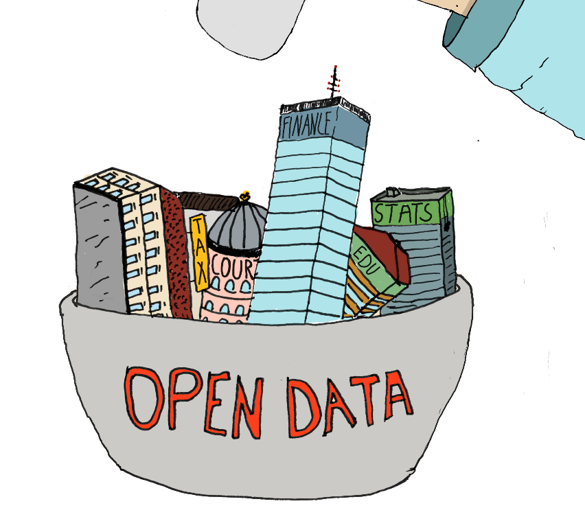
A new year for open data? (Photo Credit: Tactical Technology Collective)

By Drew Bush

In the first weeks of the New Year, two important news items for the Geothink audience made headlines. In Toronto, the Canadian federal government got ready to kick-off its second annual multi-city Canadian Open Data Experience (CODE) while the World Wide Web Foundation ranked the United States 2nd and Canada 7th for openness of governmental data in its second annual Open Data Barometer.

Canada Ranked 7th

Canada tied with Norway out of 86 countries surveyed based on whether government data was “open by default” as stipulated in the 2013 G8 Open Data Charter. Of more importance, however, was the country’s positive movement in the rankings and scores from last year, moving one spot up the index.

The survey examines availability of core government data such as company registers, public sector contracts, land titles, how governments spend money and how well public services perform. The U.K. is considered the global leader for open government data, publishing nearly all of these types of data.

Globally, the authors of the report state “there is still a long way to go to put the power of data in the hands of citizens. Core data on how governments are spending our money and how public services are performing remains inaccessible or pay-walled in most countries.”

That’s because fewer than 8 percent of surveyed countries publish datasets on subjects like government budgets, spending and contracts, and on the ownership of companies, in bulk machine-readable formats and under open re-use licenses.

A few key highlights of the report: 1. Only the U.K. and Canada publish land ownership data in open formats and under open licenses; 2. Only the U.K. and the U.S. publish detailed open data on government spending; 3. And, only the U.S., Canada and France publish open data on national environment statistics. Finally, open mapping data is only published in the U.K., the U.S. and Germany (an area where Canada lags).

CODE Hackathon Kicks-Off

In Toronto, developers, graphic designers, students, and anyone interested in trying their hand at coding are getting ready to create innovative uses for the Canadian government’s open data and to win up to $15,000 from the Government of Canada. The 48-hour event is set to begin on February 20th.

Innovations developed at hackathons like this could one day fuel improvements in access to government data. The event attracted 927 developers in 2013 and that number increased to over 1,000, organizers said, the day of the event.

“Open data is a brand new industry,” Ray Sharma, founder of the event and XMG Studios, told CTV News. “We are in an ice berg situation where we’ve only seen the tip of the data that will become available.”

But just what kind of industry is open to debate, as Geothink researchers Peter Johnson and Pamela Robinson examined in a recent paper. Their questions included whether civic hackathons have the potential to replace the traditional ways that government purchases products and services, and whether these events can be considered new vectors for citizen engagement, according to a post Johnson wrote for Geothink.

For more on CODE, you can watch Canada’s President of Treasury Board, Tony Clement here or read more about this year’s event here.

If you have thoughts or questions about the article, get in touch with Drew Bush, Geothink’s digital journalist, at drew.bush@mail.mcgill.ca.