The Vancouver Convention Centre in Vancouver, BC, Canada was the world’s first LEED Platinum-certified convention center. It also has one of the largest green roofs in Canada. Image Credit: androver / Shutterstock.com
This post is cross-posted with permission from Alexander Aylett, from UGEC Viewpoints. Aylett is an Assistant Professor at the Centre on Urbanisation, Culture and Society at the National Institute for Scientific Research (UCS-INRS) in Montreal, Quebec.
By Alexander Aylett
Since its early days, the discourse around “smart cities” has included environmental sustainability as one of its core principles. The application of new digital technologies to urban spaces and processes is celebrated for its ability to increase the well-being of citizens while reducing their environmental impacts. But this engagement with sustainability has been limited to a technocratic focus on energy systems, building efficiency, and transportation. It has also privileged top-down interventions by local government actors. For all its novelty, the smart cities discussion is operating with a vision of urban sustainability that dates from the 1990s, and an approach to planning from the 1950s.
This definition of “urban sustainability” overlooks key facets of a city’s ecological footprint (such as food systems, resource consumption, production related greenhouse gas emissions, air quality, and the urban heat island effect). It also ignores the ability of non-state actors to contribute meaningfully to the design and implementation of urban policies and programs. But that doesn’t need not be the case. In fact, if employed properly, new information technologies seem like ideal tools to address some of urban sustainability’s most persistent challenges.
Progress and Lasting Challenges in Local Climate Governance
Let’s take a step back. Often discussions of smart cities begin with an account of the capabilities of specific technologies or interfaces and then imagine urbanism – and urban sustainability – through the lense of those technologies. I’d like to do the opposite: beginning with the successes and lasting challenges faced by urban sustainability and interpreting the technologies from within that context. To understand the role that “smart” technologies could play in enabling sustainable cities, it’s useful to first look at what we have managed to accomplish so far, and what still needs to be done.
For those of us working on sustainable cities and urban responses to climate change, the past two decades have been a period of both amazing successes and enduring challenges. In the early 1990s a handful of cities began promoting the (at that time) counterintuitive idea that local governments had a key role to play in addressing global climate change. Since then, the green cities movement has won significant discursive, political, and technical battles.
Global inter-municipal organizations like ICLEI or the C40 now have memberships that represent thousands of cities. Two decades of work have created planning standards and tools and an impressive body of “best practice” literature. Through the sustained efforts of groups like ICLEI, cities are now recognized as official governmental stakeholders in the international climate change negotiations coordinated by the United Nations.
But – crucially – real urban emissions reductions are lagging well below what is needed to help keep global CO2 within safe limits. Looking at the efforts of individual cities and the results of a global Urban Climate Change Governance survey that I conducted while at MIT (Aylett 2014, www.urbanclimatesurvey.com ) shows why. Apart from a small contingent of charismatic cities like Vancouver, Portland, or Copenhagen, cities are struggling to move beyond addressing the “low hanging fruit” of emission from municipal facilities ( i.e., vehicle fleet, municipal buildings, street lighting – known as “corporate emissions”) to taking action on the much more significant emissions generated by the broader urban community (i.e., business, industry, transportation, and residential emissions).
This problem has been with us since the early days of urban climate change responses. But how we understand it has changed significantly. Where some cities used to inventory only their corporate emissions, this is now rare. Current guidelines cover community-wide emissions and work is underway to create a global standard for emissions inventories that will also engage with emissions produced in the manufacture of the goods and services consumed within cities (see Hoornweg et al. 2011).
Built on the increased scope of our technical understanding of urban emissions, is a change in how we understand the work of governing climate change at the local level. A top-down vision of climate action focused on the regulatory powers of isolated local government agencies is being replaced by one that is horizontal, relational, and collaborative. This approach transforms relationships both inside and outside of local governments, by linking together traditionally siloized municipal agencies and also forging partnerships with civil-society and business actors (Aylett 2015).
The increased prominence of non-state actors in urban climate change governance has led to growing calls for partnerships across the public-private divide (Osofsky et al. 2007; Andonova 2010; Bontenbal and Van Lindert 2008). These partnerships play an important role in overcoming gaps in capacity, translating the climate change impacts and response options into language that is meaningful to different groups and individuals, and accelerating the development of solutions. Follow-up analysis of the 2014 MIT-ICLEI Climate survey shows that these partnerships have an important positive impact on the scope of concrete emissions reductions. Cities with stronger partnerships appear to be more able to create concrete emissions reductions outside of areas directly controlled by the municipality.

The street car in Portland, Oregon, USA. Image Credit: Shutterstock.com
This evolution in approaches to climate change planning follows a broader current in urban planning more generally which, since the 1960s have moved away from expert driven and technocratic processes and created increasing amounts of space for participatory processes and facilitative government.
In a nutshell, an increasingly complex and holistic technical understanding of urban emissions is being matched by an increasing horizontal and networked approach to governing those emissions. (A similar shift is taking place in the more recent attention to urban adaptation and resilience.)
But plans and programs based on this understanding quickly run into the significant barriers of institutional siloization and path dependency, a lack of effective information sharing, challenges of data collection and analysis, and difficulty mobilizing collective and collaborative action across multiple diverse and dispersed actors (Aylett 2014). The strength of collaborative multi-stakeholder responses is also their weakness. While effective climate change action may not be possible without complex networks of governance, coordinating these networks is no simple task. The subject of urban climate change governance has been the focus of an expanding body of research (Aylett 2015, 2014, 2013; Betsill & Bulkeley 2004, 2007; Burch 2010; Burch et al. 2013; Romero-Lankao et al. 2013.)
“Smart” Urban Climate Governance
Seen from this perspective, the allure of “smart” approaches to green cities is precisely the fact that information technology tools seem so well suited to the challenges that have stalled progress so far. Collecting, sharing and analysing new and existing data, and coordinating complex multi-scalar social networks of collaborative design and implementation are precisely what has drawn attention to new technologies in other sectors.
Disappointingly, current applications of a data-driven and technologically enabled approach to urban sustainability are far from delivering on this potential. Reading through the literature shows that the many interesting works that address the impacts of new technologies on urban governance (for example Elwood 2010, Evans-Cowley 2010, Goldsmith and Crawford 2015, Moon 2002) have nothing to say about the governance of urban sustainability. Work that does address environmental sustainability is dominated by a technocratic focus on energy systems, building efficiency, and transportation that privileges top-down action by municipal experts and planning elites (The Climate Group 2008, Boorsma & Wagener 2007, Kim et al. 2009, Villa & Mitchell 2009). This literature review is ongoing, and I continue to hope to find a body of work that combines a developed understanding of urban sustainability with a detailed reflection on digital governance. As it is, we seem to be working with outdated approaches to both urban sustainability and planning.
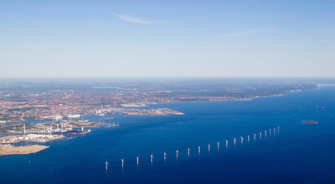
An off-shore wind farm near Copenhagen, Denmark. Image Credit: Shutterstock.com
How to update this approach, and use the full potential of data-driven, technologically enabled, and participatory approaches to spur accelerated transitions to sustainable cities is a key question. This research is necessary if we are going to unlock the full potential of the “smart” urbanism to address the necessity of building sustainable cities. It is also important that we avoid rolling back the clock on two decades of “green cities” research by basing our digital strategies around outdated understandings of the urban sustainability challenge.
Conclusions
Cities are responsible for as much as 70% of global greenhouse gas emissions and consume 75 percent of the world’s energy (Satterthwaite 2008). These figures are often repeated. But taking action at that scale requires both technological and socio-institutional innovations. Efforts to reduce urban emissions are challenged by the complexity of coordinating broad coalitions of action across governmental, private, and civil-society actors, and the need to effectively collect, share, and analyse new and existing data from across these traditionally siloized sectors.
These complexities have played an important role in limiting actual urban emissions reductions far below what is needed to stabilize global emissions within a safe range. Interestingly, these complexities are also the very strengths of emerging information and communications technologies (ICT) tools and Geoweb enabled approaches to urban planning and implementation. Currently, the use of “smart” approaches to address the urban climate challenge has been limited to narrow and technocratic initiatives. But much more is possible. If effective bridges can be built between the ICT and Urban Sustainability sectors, a profound shift in approaches to the urban governance of climate change could be possible. It is important to increase both sustainability and digital literacy among those involved. Only then will innovations in urban sustainability benefit from a deep understanding of both the new tools at our disposal, and the complex challenge to which we hope to apply them.
(A previous version of this was presented as part of the Geothink pre-event at the 2015 American Association of Geographers conference in Chicago. IL. See: www.geothink.ca)
Alexander Aylett is Assistant Professor at the Centre on Urbanisation, Culture and Society at the National Institute for Scientific Research (UCS-INRS) in Montreal, Quebec, Canada.