Our first Geothoughts Conversations piece takes a look at crowdsourcing, the topic of the 2015 Summer Institute.
By Drew Bush
One of the hallmarks of any academic conference are the conversations that take place in-between sessions, in the hallways and over meals. In our first Geothink Conversations we aim to give you a flavor of these discussions at Geothink’s now concluded 2015 Summer Institute.
Each day of the institute alternated morning lectures, panel discussions and in-depth case studies on topics in crowdsourcing with afternoon work sessions where professors worked with student groups one-on-one on their proposal to meet a challenge posed by the City of Ottawa. For more on the Institute, check out our web site at geothink.ca.
To start us off, Brabham gets the group rolling on what exactly defines the boundaries of crowdsourcing, the topic of many conversations overheard during the three-day conference.
If you have thoughts or questions about this podcast, get in touch with Drew Bush, Geothink’s digital journalist, at drew.bush@mail.mcgill.ca.
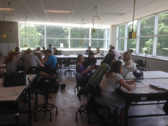
Time for each of the seven competing teams to meet and work on their proposals in the upstairs classroom of the Environment 3 Building at the University of Waterloo during Geothink’s Summer Institute.
“In my world, within a planning project or a collaborative effort, these sort of structured tools can be plugged in,” he told students of his work in developing a visual preference tool to engage the public in more formal participatory community planning processes. “Technology is forcing us to rethink our methodologies, and rethink how we think things work.”
Each day of the institute alternated morning lectures, panel discussions and in-depth case studies on topics in crowdsourcing with afternoon work sessions where professors worked with student groups one-on-one on their submission to the City of Ottawa on day three.
Not sure what constitutes crowdsourcing? The goal of the institute, run as part of a five-year Canadian Social Sciences and Humanities Research Council (SSHRC) partnership grant, was to provide undergraduate and graduate students from Geothink’s partners with knowledge and training in theoretical and practical aspects of crowdsourcing. See our post from day one to learn more about this important topic.
A random survey of users within many online mapping communities coupled with a look at interactions among members in specific communities proved revealing for Stephens.
“What became clear was that women were just as willing to socially tag, I was with so-and-so, but they weren’t willing to include the geographic information the way that men were,” Stephens told students in her case study on OpenStreetMap and other internet mapping communities. This simple fact, she demonstrated, has profound impacts on the types of features and attributes that get approved for inclusion on many maps.
Watch a clip of Stephens’s talk to find out how she conducted her research here:
For the students, the afternoon proved just as stimulating as all seven groups presented their initial concepts to the professors for feedback and guidance.
“I come from a GIS/Urban Planning background, and I found out about this through a professor,” said Alexa Hinves, a master’s student in Ryerson University’s Department of Geography who competed as a member of the group GeoPlay. “To me it’s just kind of incredible…you get to get together and do so many different activities. It’s not just you’re going to a conference and you’re listening to people for hours about what their interests are. But you are also sitting down and doing an intensive project and getting a lot of different perspectives.”
“You also get to think out of the box,” added her teammate, Ashley Zhang, a Ph.D. candidate at Waterloo University’s Department of Geography and Environmental Management.
Stay tuned for more iTunes podcasts from the Summer Institute here, check back on Geothink.ca for our last synopses of day three, and, of course, watch more of our video clips (which we’ll be uploading in coming days) here.
If you have thoughts or questions about this article or the video content, get in touch with Drew Bush, Geothink’s digital journalist, at drew.bush@mail.mcgill.ca.
Each day of the institute alternated morning lectures, panel discussions and in-depth case studies on topics in crowdsourcing with afternoon work sessions where professors worked with student groups one-on-one on their proposed solution to the City of Ottawa’s challenge. As the institute progressed, more time was given to the seven student groups to work on their solutions and prepare a final pitch to the city on day three.
Not sure what constitutes crowdsourcing? The goal of the institute, run as part of a five-year Canadian Social Sciences and Humanities Research Council (SSHRC) partnership grant, was to provide undergraduate and graduate students from Geothink’s partners with knowledge and training in theoretical and practical aspects of crowdsourcing. And that’s a topic Brabham has been studying, as he puts it modestly, for “several years.”
“And I’ve been trying to look at how to take this model, which I define as connecting organizations with online communities to mutually solve problems or produce goods,” he told Geothink. “Taking that model which as been used in business and a number of for profit endeavours and trying to translate it for governments, for non-profits, for public health.”
On Day 1, students at Geothink’s Summer Institute worked together to solve Ottawa’s crowdsourcing problem using the knowledge gained in earlier sessions as well as individual areas of expertise. Much like many real-world challenges that crowdsourcing has been used to address, the presentation from the City of Ottawa made clear that the problem the city faced was complex and multifaceted. Goodspeed helped to summarize some elements of what was expected of students.
“What a wonderful, rich context, I mean, who knows what the problem is?” he told students. “Is it that people are going to too many parks or the wrong parks, or which people are we talking about? We have no idea…And I think this is very typical for a lot of problem settings you’ll encounter. And, in that sense, almost any month they showed could have been itself a crowdsourcing application.”
Watch a clip of Goodspeed’s introduction here:
After they’d been given a chance to start discussing ideas for crowdsourcing applications in their groups, Sieber and Stephens helped students to begin thinking about the geographical aspects of the applications they were designing as well as technical limitations they might face.
“So, this is a summer institute on crowdsourcing, why do we even talk about geography?” Sieber told students later in the first day. “Because most open data, most data that comes out of government has some geographic component in it somewhere. So it’s useful often to tie crowdsourcing to geography.”
“If nothing else, that implies there is a jurisdictional aspect to the way that people communicate with government, that is that people are bounded in place,” she added.
Stay tuned for more iTunes podcasts from the Summer Institute here, check back on Geothink for synopses of days two and three, and, of course, watch more of our video clips (which we’ll be uploading in coming days) here.
Watch a clip of the presentation the City of Ottawa gave our students here (Beware, for the technophobic, it was conducted over videoconference).
If you have thoughts or questions about this article or the video content, get in touch with Drew Bush, Geothink’s digital journalist, at drew.bush@mail.mcgill.ca.
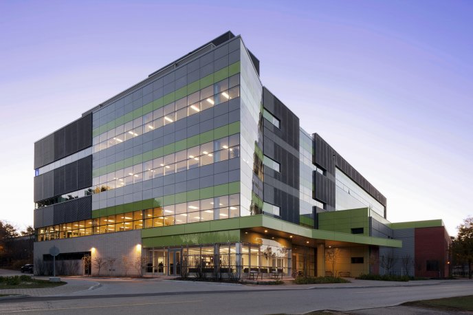
The Environment 3 Building (EV3), at the University of Waterloo, where the summer institute will be held.
By Drew Bush
Get ready Geothinkers, this year’s Geothink Summer Institute will run from June 15-16, 2015 and will be held at the University of Waterloo in Waterloo, Ontario. Check in at our Summer Institute web site, where we’ll be live tweeting the day’s events.
The agenda is jam-packed with big names in the emergent field of crowdsourcing, which one Geothinker calls “a web-based business model that harnesses the creative solutions of a distributed network of individuals.” That’s from the University of Southern California Annenberg School of Journalistm and CommunicationAssistant Professor Daren Brabham, who will be giving one of the morning’s first sessions to more than 30 undergraduate and graduate students who have registered to attend.
Speakers will explore topics related to crowdsourcing in a hyperlocal world where geospatial technologies like Google Maps and GPS-enabled cellphones enable massive quantities of data to be collected. In today’s world, there are tweets about potholes, mobile applications which deliver directions to the nearest coffee shop, and large databases only recently opened by many governments around the world.
The summer institute is hosted by Geothink, a five-year partnership grant awarded by the Canadian Social Sciences and Humanities Research Council (SSHRC) in 2012. The partnership includes researchers in different institutions across Canada, as well as partners in Canadian municipal governments, non-profits and the private sector. The expertise of our group is wide-ranging and includes aspects of social sciences as well as humanities such as: geography, GIS/geospatial analysis, urban planning, communications, and law.
If you have thoughts or questions about the article, get in touch with Drew Bush, Geothink’s digital journalist, at drew.bush@mail.mcgill.ca.