Category Archives: Refereed Publications & Conferences

Paper Spotlight: The Cost(s) of Geospatial Open Data

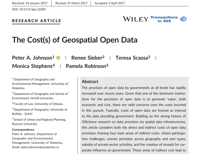
Five Geothink researchers published a new paper in Transactions in GIS this past January that reflected on four years of research into how geospatial open data can impact the relationship between government, its citizens and the private sector.

By Drew Bush

In their article published this past January, five Geothink researchers reflected on four years of research into how geospatial open data can impact the relationship between government, its citizens and the private sector. In it, they examine how geospatial open data poses challenges for civic participation related to subsidizing the private sector, being provisioned equally across geography and user type, and in increasing corporate influence on government.

Published by Transactions in GIS, the article entitled “The Cost(s) of Geospatial Open Data” concludes with the development of critical questions to guide governments that provide open data in addressing costs related to constituency, purpose, enablement, protection, and priorities.
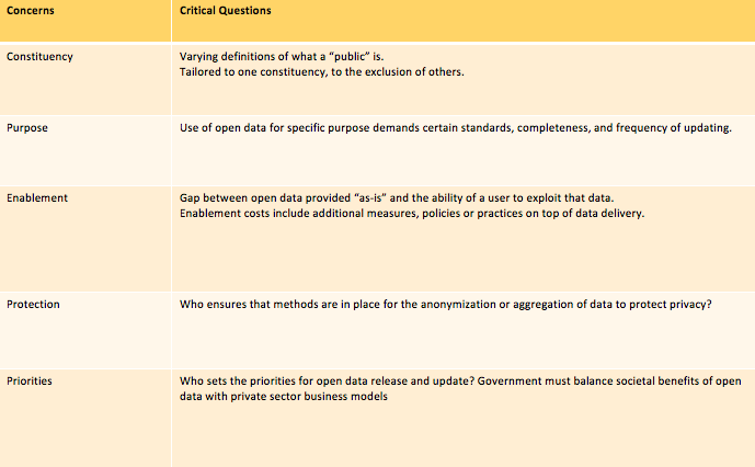
A key table from the “The Cost(s) of Geospatial Open Data” which lays out the critical questions in each of these areas for municipalities.

“What we were trying to do is to push the conversation of ‘value’ for open data beyond the typical areas of transparency, economic innovation, and service to citizens, and look more at what the generation of value can create in terms of additional costs,” Geothink Co-Applicant Peter Johnson, the paper’s first author and an associate professor in the University of Waterloo’s Department of Geography and Environmental Management, wrote in an e-mail. “So, for example, we talk about how there is a lot of interest in how open data can promote transparency, which is a great outcome. However, this can’t be conflated with more durable challenges like citizen participation and citizen engagement.”

“Simply putting open data out there won’t move the needle on those,” he added. “Rather, government must continue to work hard and use open data to help further those ends, but not as a replacement.”

Johnson’s co-authors on the paper were Geothink Principal Investigator Renee Sieber, associate professor in McGill University’s Department of Geography and School of Environment; Geothink Co-Applicant Teresa Scassa, Canada research chair in Information Law at the University of Ottawa; Geothink Collaborator Monica Stephens, assistant professor at The State University of New York, Buffalo; and Geothink Co-Applicant Pamela Robinson, the associate dean for Ryerson University’s Faculty of Community Services and an associate professor in the School of Urban and Regional Planning.

They note in the paper that their research funded by the Social Sciences and Humanities Research Council of Canada has evolved to examine the costs of open data that have emerged, and shown that “spatial is special” and that the broader open data research community that “draws upon a different set of assumptions and literatures, would benefit from the lessons learned in GIScience.” The paper then goes on to create “a framework that details direct and indirect costs created through the process of government open data provision, drawn from the perspectives of our key informants in municipal governments. Many of the indirect costs are external to the providing organization and are not always clear or straightforward.”

“Open data may enable a kind of smoke and mirrors that obscures a government’s actual commitment to citizen participation, transparency and accountability,” said Sieber. “The challenges of using open data as a platform for citizen participation and engagement can be exacerbated where insufficient government resources are deployed to ensure that open data sets are properly prepared for release.”

Johnson agreed.

“We are just holding our hands up and saying ‘Wait, this is more complicated than you think,’” he wrote. “Especially when we think of issues like protection of privacy for health or financial data, there are a lot of things to think through in parallel to just ‘How are we going to use (exploit) this data?’ So, for future research on this topic, I think that there is a lot to be done. Who is using open data and what are the ups and downs of using it?”

The Cost(s) of Geospatial Open Data
Abstract
The provision of open data by governments at all levels has rapidly increased over recent years. Given that one of the dominant motivations for the provision of open data is to generate ‘value’,both economic and civic, there are valid concerns over the costs incurred in this pursuit. Typically, costs of open data are framed as internal to the data providing government. Building on the strong history of GIScience research on data provision via spatial data infrastructures, this article considers both the direct and indirect costs of open data provision, framing four main areas of indirect costs: citizen participation challenges, uneven provision across geography and user types, subsidy of private sector activities, and the creation of inroads for corporate influence on government. These areas of indirect cost lead to the development of critical questions, including constituency, purpose, enablement, protection, and priorities. These questions are posed as a guide to governments that provide open data in addressing the indirect

###

If you have thoughts or questions about the article, get in touch with Drew Bush, Geothink’s digital journalist, at drew.bush@mail.mcgill.ca.

On the Hunt for Social Justice and Empowerment

By Logan Cochrane, Mark Gill, Jon Corbett

The participatory geoweb has the potential to transform relations of power – who contributes and names places, what is excluded and labeled. This transformation can occur through newfound opportunities for engagement and giving voice to spatially relevant issues. In the 1990s, GIScience recognized this potential and made explicit the importance that social issues would, and should take within the discipline and practice. Geothink did likewise, making social justice one of its key themes. While Web 2.0 and the geoweb has promised greater forms of equality, particularly through supporting user generated content, we know that maps remain value-laden, and are embedded with particular power relations that are not necessarily equally distributed. Social justice is a term that describes the equitable distribution of resources, opportunities, and privileges within society. Amidst the Web 2.0 enthusiasm, we were interested in how issues of social justice are being addressed within the context of the geoweb in academic literature. You might be surprised what we found.

We first set out to take stock of the current state of GIScience literature (Cochrane et al, 2016). Using the ten most highly ranked academic journals by GIScientists. We assessed ten years of literature. We narrowed the more than 14,000 articles published from 2005 to 2014 to those having some relationship to the geoweb and/or crowdsourcing, using broad and inclusive terms. Of the resulting sub-set, we searched for social justice, and terms related to it, for example empowerment. We found that only three articles engaged explicitly with social justice . Even more surprising, terms related to social justice (empowerment, marginalization, social change, environmental justice, spatial justice, etc), were limited to the marginal periphery of these top tier journals. In other words, these ideas tended not to be the main content of the research. We argue that GIScience runs the risk of missing important insights , as mapmakers around the world are engaged in practice, but ignored in top tier GIScience journals.

Finding that social justice was more likely to be a footnote than a substantial focus of the research endeavour or engagement, we then wondered about empowerment. We had searched for it in the original article, but wanted to expand the search (adding ten more years of journals, 1996-2014, and using an open search rather than specific journals) and go into more detail (Corbett, Cochrane and Gill, 2016). Empowerment is of particular interest for GIScience because so many assume the use of the participatory geoweb results in empowerment. While the usage of the term has increased with time, the concept was consistently ill-defined and insufficiently measured. Amazingly, almost one quarter (24%) of the articles that mentioned “empowerment” were not included in the main text, but in places such as the works cited list or an endnote. Even of those that did engage with the concept in a substantial way, only a minority defined the term, fewer still explained how they measured it, and only five listed the specific metrics. We argue that researchers should make a greater effort to adequately define what they mean by “empowerment” and provide a way to actually assess how projects are providing that particular empowerment.

These two papers act as key reference points for those interested in the participatory geoweb. While our papers do not negate the potential for positive impacts, they highlight the fact that research commonly does not engage with social justice, and when terms like empowerment are used, they are often not defined or cannot justify claims of positive impact. As Web 2.0 technologies encourage people to take part in creating knowledge, through maps or otherwise, we need researchers to study how participatory and crowdsourcing approaches to map making intersect with issues of social justice. Based on these findings, we hope to draw attention to this important aspect of GIScience which has long been identified as a crucial area of research.

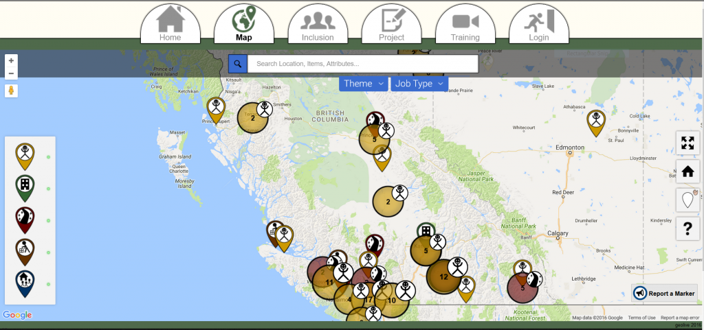
Dr. Corbett's research team are tackling issues of empowerment via the geoweb and have developed tools such as GeoLive

Dr. Corbett’s research team are tackling issues of empowerment via the geoweb and have developed tools such as GeoLive

For more information, see the two papers this post was based on:
Cochrane, L., Corbett, J., Evans, M. and Gill, M. 2016. Searching for Social Justice in GIScience Publications. Cartography and Geographic Information Science http://dx.doi.org/10.1080/15230406.2016.1212673

Corbett, J., Cochrane, L. and Gill, M. 2016. Powering Up: Revisiting Participatory GIS and Empowerment. The Cartographic Journal http://dx.doi.org/10.1080/00087041.2016.1209624

Paper Spotlight: Fostering Citizen Trust in Municipal Government

Screen Shot 2016-08-15 at 8.56.32 AM

A new IMFG Perspectives paper posit five steps to foster citizen trust in Canadian municipalities.

By Drew Bush

In a new article, Geothink Co-Applicant Pamela Robinson and her co-author, Dina Graser, posit five steps to foster citizen trust in Canadian municipalities as they attempt to raise funds to cope with almost $400 billion of infrastructure deficit nationwide.

Pamela Robinson is an associate professor at Ryerson University’s School of Urban and Regional Planning.

Pamela Robinson is an associate professor at Ryerson University’s School of Urban and Regional Planning.

Published by the Institute on Municipal Finance and Governance (IMFG) at University of Toronto’s Munk School of Global Affairs, A Recipe for Fiscal Trust (No. 13) reviews literature on public trust in government. In September, the authors will host a seminar to elaborate on their work. (Check back here for details when they become available.)

“There’s no shortcuts,” Robinson, an associate professor at Ryerson University’s School of Urban and Regional Planning, said of the paper. “We have to stop thinking about civic engagement and relationship building between local government and members of the general public as discreet events and things that you tick-off, ‘Like, ok, I’ve done that.’ There are—the ways in which relationships are built and maintained and nurtured and cultivated is the active work of government.”

She sees this research as building upon previous Geothink research examining the ways in which civic hackathons reshape citizen-government interactions along with open data. Instead of interrogating how open data makes municipalities more accountable or transparent (or may fail to), this paper examines how it shapes levels of public trust in government. Robinson adds that data itself is not a panacea.

“Data is an input into our process but the data itself won’t give you trust or transparency,” she said. “You have to use the data embedded in broader processes of civic engagement. And so the portal is just the beginning—it’s not the end.”

Robinson warns that the longer municipalities wait to build trust and raise funds, the greater the challenge will be in terms of the huge backlog of municipal infrastructure work that needs to be completed. Particular challenges include governments strapped for resources and money, news cycles with shorter attention spans, and citizen fatigue with governmental processes. Yet, new transit lines or bridges require sustained community engagement.

“Not only is the process of maintaining good citizen-local government relationships really important and hard work,” Robinson said. “It’s going to require more and more attention. And it can’t be just that thing that those people over there do. It needs to be internalized.”

Find the executive summary and citation for the article below:

Citation
Graser, D. & Pamela, R. (2016) A Recipe for Fiscal Trust. IMFG Perspectives, No. 13, p. 1-20.

Executive Summary
Cities across Canada face an enormous infrastructure deficit. From 100-year-old water mains to transit systems in vital need of upgrading and expansion, Canadian infrastructure is widely recognized to be in dire straits. And while the majority of Canadians elected a new government that was prepared to run a deficit to fund infrastructure, these funds alone will not cover the investments needed.

Local governments need to make significant financial investments, too, and must raise revenues through taxes, user fees, and possibly new revenue tools. But before they can take these actions, they have to build trust to convince heir residents that new revenues are needed and will be spent wisely.

What does it mean to build trust? This paper examines the notion of trust and how governments can build it using:

  • Good information: relevant data made accessible to citizens and attractively packaged to enhance transparency;
  • Good communications: good stories that are well told, with relevant information distributed through a variety of channels (using open government tools and techniques);
  • Good engagement: inclusive and meaningful opportunities for dialogue about policy decisions to build the continuum of trust (using a variety of mechanisms);
  • Credibility: building an effective track record and controlling costs (through better performance benchmarking and other approaches);
  • Earmarking of funds: creating a dedicated fund that clearly links revenues raised to specific expenditures, and regularly reporting on the progress of projects funded.

This research shows that there are concrete and practical steps that cities can take to build fiscal trust – but there are no shortcuts. Trust-building is a long-term proposition that takes resources. Cities must invest the time and dedicate the resources to build trust through all of the steps outlined, and continue to do so as part of their regular activities.

Paper Spotlight: Examining Urban Reasoning Skills in the Age of Digital Cities

Smart citizens

Smart citizens of the future must develop the skillsets required to understand spatio-temporal interactions in dynamically linked urban networks of places according to Geothink Co-Applicant Stéphane Roche (Photo courtesy of http://www.i2cat.net/sites/default/files/smart-city.jpg).

By Drew Bush

In a paper published this past May, Geothink Co-Applicant Stéphane Roche posits that emerging smart cities require citizens to develop an urban intelligence that meshes material realities with digital information. In order to fully manage and engage with urban spaces, future smart citizens must develop the skillset required to understand spatio-temporal interactions in dynamically linked urban networks of places.

Stéphane Roche is a professor and vice dean of research for the Faculty of Forestry, Geography, and Geomatics at the University of Laval (Photo courtesy of www.scg.ulaval.ca).

Entitled Geographic information science III: Spatial thinking, interfaces and algorithmic urban places-Toward smart cities, the paper was published in Progress in Human Geography. Roche, a professor and vice dean of research for the Faculty of Forestry, Geography, and Geomatics at the University of Laval, has previously written two papers on the subject. The series of papers defines urban intelligence, the importance of spatial reasoning in smart cities, and the organization of digitally enabled cities.

“Most of the resources that are today available in order to help people to move in the city, are available—are digitally available,” Roche said. “[Yet] at the same time, mobility in the city is really grounded in the materiality. If you need to walk or if you need to take your bike, it’s an active kind of mobility. And if you don’t really know perfectly the places where you need to travel, you need to have the minimum capability to access information from different kinds of interfaces. Through your phone, through the Internet, through a different kind of display available in the city for example.”

Transportation presents but one case study for examining the integration of digital technology into physical urban places. Roche expands on this interaction to further define place as consisting of three elements: 1) A geographical location; 2) An event (such as an accident, festival, or meeting); and 3) A name. This, of course, means that two separate places could involve the same physical space but at different times.

As you may imagine, this type of insight takes time to develop. After reflecting on the existing literature in the field, along with his own previous work, Roche begins his first paper, Geographic Information Science I: Why does a smart city need to be spatially enabled? by emphasizing the importance of Geographic Information Science (GIS) to smart cities. He argues that the smart city is first and foremost a spatially enabled city.

His second paper, Geographic information science II: Less space, more places in smart cities, Roche advances the idea that modern cities consist of networks of connecting places, amends the very definition of place, and posits urban intelligence as the capability to understand how urban places are created and how they interact. Finally, his most recent third paper comes full circle to question why people who have developed urban intelligence necessarily also employ spatial learning and reasoning skills.

“Actually, what I’ve tried to do in this report is probably link what I define as the urban intelligence,” he said. “That means the capability of someone, people, or a group to understand the urban dynamic by using spatial skills and spatial thinking abilities. That means making the link between different components of the urban environment. So this is what I define as the urban intelligence. The capability of understanding what’s happened at the specific time and specific place.”

“The aim, ok, is to say in our current modern environment, there are multiple opportunities and tools and approaches that could help humans to improve their spatial thinking ability,” he added. “And these improvements will be more and more required if people want to engage. That means they will, there is no way to keep them engaged without spatial thinking abilities in this kind of new urban environment where everything is connected. Where everything is based on dynamic fluxes and mobilities. So if you are not able to understand how those dynamics work, you will have more and more difficulty in getting grounded in the place where you live.”

Please find links and abstracts to each paper mentioned in this article below:

Abstract 1
Geographic Information Science I: Why does a smart city need to be spatially enabled?
In this report I propose to examine the concept of the ‘smart city’ from the standpoint of spatial enablement. I analyse emerging research on smart cities, particularly those addressing the potential role of GISciences in the development and implementation of the concept of smart cities. I develop the idea that the intelligence of a city should be measured by its ability to produce favourable conditions to get urban operators (citizens, organizations, private companies, etc.) actively involved into sociospatial innovation dynamics. To obtain such a commitment, I believe that operators should be able to develop and mobilize (digital) spatial skills so that they could efficiently manage their spatiality. In other words, I argue that a smart city is first of all a spatially enabled city.

Abstract 2
Geographic information science II: Less space, more places in smart cities
This second report is dedicated to the concept of ‘place’ revisited in the context of smart cities. Some recent studies suggest that today’s digital cities rely more on an approach to the urban context based on a network of connected places than on an approach to the city built on areal spaces. Does it mean that there are more places and fewer spaces in spatially enabled cities? Is the intelligence of a city mainly related to its ability to sound out the genesis of urban places? These issues raise questions about the design of spatial models used to build GIS, as well as place-based urban design methods and tools. This second report explores these questions from the standpoint of GISciences.

Abstract 3
Geographic information science III: Spatial thinking, interfaces and algorithmic urban places—Toward smart cities
This third report examines interfaces as a key element enabling spatial skills, and development of new forms of digital spatialities for smart cities. Digital technology is becoming consubstantial to urban materiality, but map interfaces are particularly central tools for indexing (geographic) knowledge and expertise, accessing informational components of digital cities, and actively engaging digital dimensions of urban places.

If you have thoughts or questions about the article, get in touch with Drew Bush, Geothink’s digital journalist, at drew.bush@mail.mcgill.ca.

Getting a Better Handle on Geosocial Data with Geothink Co-Applicant Robert Feick

 Images and text from sites like Flickr (the source of this image) provide geosocial data which University of Waterloo Associate Professor Robert Feick and his graduate students work to make more useful to planners and citizens.

Images and text from sites like Flickr (the source of this image) provide geosocial data that University of Waterloo Associate Professor Robert Feick and his graduate students work to make more useful to planners and citizens.

By Drew Bush

A prevailing view of volunteered geographic information (VGI) is that large datasets exist equally across North American cities and spaces within them. Such data should therefore be readily available for planners wishing to use it to aid in decision-making. In a paper published last August in Cartography and Geographic Information Science, Geothink Co-Applicant Rob Feick put this idea to the test.

He and co-author Colin Robertson tracked Flickr data across 481 urban areas in the United States to determine what characteristics of a given city space correspond to the most plentiful data sets. This research allowed Feick, an associate professor in the University of Waterloo’s School of Planning, to determine how representative this type of user generated data are across and within cities.

The paper (entitled Bumps and bruises in the digital skins of cities: Unevenly distributed user-generated content across U.S. urban areas) reports that coverage varies greatly between downtown cores and suburban spaces, as may be expected, but also that such patterns differ markedly between cities that appear similar in terms of size, function and other characteristics.

“Often it’s portrayed as if these large data resources are available everywhere for everyone and there aren’t any constraints,” he told Geothink.ca recently about this on-going research. Since these data sets are often repurposed to learn more about how people perceive places, this misconception can have clear implications for those working with such data sets, he added.

“Leaving aside all the other challenges with user generated data, can we take an approach that’s been piloted let’s say in Montreal and assume that’s it going to work as well in Hamilton, or Calgary, or Edmonton and so on?” he said. Due to variations in VGI coverage, tools developed in one local context may not produce the same results elsewhere in the same city or in other cities.

The actual types of data used in research like Feick’s can vary. Growing amounts of data from social media sites such as Flickr, Facebook, and Twitter, and transit or mobility applications developed by municipalities include geographic references. Feick and his graduate students work to transform such large datasets—which often include many irrelevant (and unruly) user comments or posts—into something that can be useful to citizens and city officials for planning and public engagement.

“My work tends to center on two themes within the overall Geothink project,” Feick said. “I have a longstanding interest in public engagement and participation from a GIS perspective—looking at how spatial data and tools condition and, hopefully, improve public dialogue. And the other broad area that I’m interested in is methods that help us to transform these new types of spatial data into information that is useful for governments and citizens.”

“That’s a pretty broad statement,” he added. “But in a community and local context, I’m interested in both understanding better the characteristics of these data sources, particularly data quality, as well as the methods we can develop to extract new types of information from large scale VGI resources.”

Applying this Research Approach to Canadian Municipalities

Much of Feick’s Geothink related research at University of Waterloo naturally involves work in the Canadian context of Kitchener, Waterloo, and the province of Ontario. He’s particularly proud of the work being done by his graduate students, Ashley Zhang and Maju Sadagopan. Both are undertaking projects that are illustrative of Feick’s above-mentioned two areas of research focus.

Many municipalities offer Web map interfaces that allow the public to place comments in areas of interest to them. Sadagopan’s work centres on providing a semi-automated approach for classifying these comments. In many cases, municipal staff have to read each comment and manually view where the comment was placed in order to interpret a citizen’s concerns.

Sadagopan is developing spatial database tools and rule-based logic that use keywords in comments as well as information about features (e.g. buildings, roads, etc.) near their locations to filter and classify hundreds of comments and identify issues and areas of common concern. This work is being piloted with the City of Kitchener using data from a recent planning study of the Iron Horse Trail that that runs throughout Kitchener and Waterloo.

Zhang’s work revolves around two projects that relate to light rail construction that is underway in the region of Waterloo. First, she is using topic modeling approaches to monitor less structured social media and filter data that may have relevance to local governments.

“She’s doing work that’s really focused on mining place-based and participation related information from geosocial media as well as other types of popular media, such as online newspapers and blogs, etc.,” Feick said. “She has developed tools that help to start to identify locales of concern and topics that over space and time vary in terms of their resonance with a community.”

“She’s moving towards the idea of changing public feedback and engagement from something that’s solely episodic and project related to something that could include also this idea of more continuous forms of monitoring,” he added.

To explore the data quality issues associated with VGI use in local governments, they are also working on a new project with Kitchener that will provide pedestrian routing services based on different types of mobility. The light rail project mentioned above has disrupted roadways and sidewalks with construction in the core area and will do so until the project is completed in 2017. Citizen feedback on the impacts of different barriers and temporary walking routes for people with different modes of mobility (e.g. use of wheelchairs, walkers, etc.) will be used to study how to gauge VGI quality and develop best practices for integrating public VGI into government data processes.

The work of Feick and his students provides important insight for the Geothink partnership on how VGI can be used to improve communication between cities and their citizens. Each of the above projects has improved service for citizens in Kitchener and Waterloo or enhanced the way in which these cities make and communicate decisions. Feick’s past projects and future research directions are similarly oriented toward practical, local applications.

Past Projects and Future Directions

Past projects Feick has completed with students include creation of a solar mapping tool for Toronto that showed homeowners how much money they might make from the provincial feed-in-tariff that pays for rooftop solar energy they provide to the grid. It used a model of solar radiation to determine the payoff from positioning panels on different parts of a homeowner’s roof.

Future research Feick has planned includes work on how to more effectively harness different sources of geosocial media given large data sizes and extraneous comments, further research into disparities in such data between and within cities, and a project with Geothink Co-Applicant Stéphane Roche to present spatial data quality and appropriate uses of open data in easy-to-understand visual formats.

If you have thoughts or questions about this article, get in touch with Drew Bush, Geothink’s digital journalist, at drew.bush@mail.mcgill.ca.

Abstract of Paper mentioned in the above article:

Bumps and bruises in the digital skins of cities: Unevenly distributed user-generated content across U.S. urban areas
Abstract
As momentum and interest builds to leverage new user-generated forms of digital expression with geographical content, classical issues of data quality remain significant research challenges. In this paper we highlight the uneven textures of one form of user-generated data: geotagged photographs in U.S. urban centers as a case study into representativeness. We use generalized linear modeling to associate photograph distribution with underlying socioeconomic descriptors at the city-scale, and examine intra-city variation in relation to income inequality. We conclude with a detailed analysis of Dallas, Seattle, and New Orleans. Our findings add to the growing volume of evidence outlining uneven representativeness in user-generated data, and our approach contributes to the stock of methods available to investigate geographic variations in representativeness. We show that in addition to city-scale variables relating to distribution of user-generated content, variability remains at localized scales that demand an individual and contextual understanding of their form and nature. The findings demonstrate that careful analysis of representativeness at both macro and micro scales simultaneously can provide important insights into the processes giving rise to user-generated datasets and potentially shed light into their embedded biases and suitability as inputs to analysis.


Geothink at the 2016 Annual Meeting of the American Association of Geographers

By Drew Bush

From March 29 to April 2, 2016, Geothink’s students, co-applicants, and collaborators presented their research and met with colleagues at the now concluded 2016 Association of American Geographers (AAG) Annual Meeting in San Francisco, CA. Over the week, Geothinkers gave 11 presentations, organized six sessions, chaired five sessions, and were panellists on four sessions. See who attended here.

“This year’s AAG provided a great opportunity to get geographically diverse Geothinkers together,” Victoria Fast, a recently graduated doctoral student in Ryerson University’s Department of Geography and Environmental Studies, wrote in an e-mail to Geothink.ca. “I can’t think of a better place for a meeting about a special journal issue on open data; there are so many fresh, uncensored ideas flying around the conference, both inside and outside of sessions.”

Of particular note for Fast was Panel Session 1475 Gender & GIScience (see her Geothink.ca guest post here). Panelists in the session included Geothink Head Renee Sieber, associate professor in McGill University’s Department of Geography and School of Environment; And, Geothink collaborator Sarah Elwood, a professor in University of Washington’s Department of Geography.

Others agreed.

“A panel on gender and GIScience was refreshing and enlightening,” Geothink Co-Applicant Scott Bell, a professor of Geography and Planning at University of Saskatchewan, wrote to Geothink.ca.

“My presentation was in a day long symposium on human dynamism,” he added. “It summarized a recently published Geothink aligned paper on human mobility tracking and active transportation (published in the International Journal of Geographical Information Science). It seemed to go over pretty well, I’m glad I was in the day-long event as the room was packed most of the day.”

For others, the high cost of the location meant they couldn’t stay for a full week or attend every single session. Still they reported good turnout by members of the Geothink team.

“This year we did not organize a specific panel or panels, or specific sessions to showcase Geothink work,” wrote Geothink Co-Applicant Teresa Scassa, Canada Research Chair in Information Law and professor in the Faculty of Law at the University of Ottawa. “This meant that our presentations were dispersed across a variety of different sessions, on different days of the week.”

Many Geothinkers were also intimately involved in running parts of the conference.

“This was a standout AAG for me,” wrote Geothink researcher Alexander Aylett, a professor and researcher at the Institut national de la recherche scientifique, who ran three sessions (Find an overview of what Aylette’s sessions did at www.smartgreencities.org). In collaboration with Andrés Lluque-Ayla from Durham University we ran a full day of sessions on the overlap between “Smart” and “Sustainable” cities.   We had some excellent presentations—including one from fellow Geothinker Pamela Robinson—and a strong turn out throughout the whole day. (Even at 8 AM, which was a shock to me!).”

For some students, it was the first time they had attended the meeting or presented their own research.

“This was my first time at the AAG,” said Geothink Newsletter Editor, Suthee Sangiambut, a maser’s student in McGill University’s Department of Geography with Sieber. “I was quite excited to be at the event and was able to meet all kinds of geographers, all of whom had different ideas on what geography exactly is.”

“It was great to see how global events of the past years were shaping our discussions on the Geoweb, privacy, surveillance, national identity, immigration, and more,” he added. “Those at the Disrupt Geo session were able to hear perspectives from private sector and civil society sides, which was quite refreshing and is something I would like to see more of in the future.”

The AAG annual meeting has been held every year since the association’s founding in 1904. This year’s conference included more than 9,000 attendees.

If you have thoughts or questions about this article, get in touch with Drew Bush, Geothink’s digital journalist, at drew.bush@mail.mcgill.ca. We also want to thank Victoria Fast for her willingness to share photos from the 2016 AAG Annual Meeting.

Please find an abstract for the presentation mentioned in this article below.

Leveraging Sensor Networks to Study Human Spatial Behavior

Abstract:
In the past decade society has entered a technological period characterized by mobile and smart computing that supports input and processing from users, services, and numerous sensors. The smartphones that most of us carry in our pockets offer the ability to integrate input from sensors monitoring various external and internal sources (e.g., accelerometer, magnetometer, microphone, GPS, wireless internet, Bluetooth). These relatively raw inputs are processed on the phones to provide us with a seemingly unlimited number of applications. Furthermore, these raw inputs can be integrated and processed in ways that can offer novel representations of human behavior, both dissagregate and aggregate. As a result, new opportunities to examine and better understand human spatial behaviour are available. An application we report here involved monitoring of a group of people over an extended period of time. Monitoring is timed at relatively tightly spaced intervals (every 2 minutes). Such a research setting lends itself to both planned and natural experiments; the later of which emerge as a result of the regular and on going nature of data collection. We will report on both a natural experiment  and planned observations resulting from 3 separate implementations of our smartphone based observations. The natural experiment that emerged in the context of our most recent month-long monitoring study of 28 participants using mobile phone-based ubiquitous sensor monitoring will be our focus, but will be contextualized with related patterns from earlier studies. The implications for public health and transportation planning are discussed.

Geothink Program Guide for the American Association of Geographers (AAG) 2016 Annual Meeting

By Drew Bush

The Annual Meeting of the American Association of Geographers will be in San Francisco, CA from March 29 to April 2.

The Annual Meeting of the American Association of Geographers will be in San Francisco, CA from March 29 to April 2.

A large number of Geothinkers will be presenting at this year’s American Association of Geographers (AAG) Annual Meeting in San Francisco, CA the last week in March. You won’t want to miss two of our co-applicants and one of our students making presentations on Tuesday in the 10:00 AM session Data in action: Tracing the open data experiment. Other highlights include Renee Sieber and Sarah Elwood as panellists in Gender & GIScience.

Below we’ve compiled the schedule for all of Geothink’s co-applicants, collaborators and students who will be presenters, panelists, organizers, and chairs during the conference. Find a PDF of this program here. We hope you find this useful for finding the right sessions to join. You can also find the full searchable preliminary AAG program here.

If you’re not able to make the conference, you can follow along on Twitter and use our list of Twitter handles below to join the conversation with our participants.

Join the Conversation on Twitter:
Alex Aylett: @openalex_                   Peter Johnson: @peterajohnson
Tenille Brown: @TenilleEBrown      Pamela Robinson: @pjrplan
Jonathan Corbett: @joncorbett      Teresa Scassa: @teresascassa
Sarah Elwood: @SarahElwood1      Renee Sieber: @RE_Sieber
Victoria Fast: @VVFast                      Suthee Sangiambut: @notgregorypeck
Sara Harrison: @Sara_Harrison79  Scott Bell: @scottyBgeo
Stéphane Roche: @Geodoc31

And remember to use the conference hashtag #AAG2016 and our hashtag #Geothink or handle @geothinkca when you Tweet.

Come to our Sessions at AAG 2015:

Tuesday, March 29

Wednesday, March 30

Thursday, March 31

Friday, April 1

Saturday, April 2

If you have thoughts or questions about this article, get in touch with Drew Bush, Geothink’s digital journalist, at drew.bush@mail.mcgill.ca.

Image Source: Zheng Zeng, Creative Commons 4.0

Spotlight on Recent Publications: Open Data and Official Language Regimes

screenshotCanadian  open government website

The bilingual federal Open Government portal

By Naomi Bloch

Teresa Scassa is a Geothink co-applicant researcher and Canada Research Chair in Information Law at the University of Ottawa. In a recently published paper, Scassa and co-author Niki Singh consider some of the challenges that arise for open data initiatives operating in multilingual regions. The authors use Canada’s federal open data initiative as a case study to examine how a government body in an officially bilingual jurisdiction negotiates its language obligations in the execution of its open data plan.

The article points out two areas for potential concern. First, private sector uses of government data could result in the unofficial outsourcing of services that otherwise would be the responsibility of government agencies, “thus directly or indirectly avoiding obligations to provide these services in both official languages.” Second, the authors suggest that the push to rapidly embrace an open data ethos may result in Canada’s minority language communities being left out of open data development and use opportunities.

According to Statistics Canada’s 2011 figures, approximately 7.3 million people — or 22 percent of the population — reported French as their primary language in Canada. This includes over a million residents outside of Quebec, primarily in Ontario and New Brunswick. Canada’s federal agencies are required to serve the public in both English and French. This obligation is formalized within Canada’s Charter of Rights and Freedoms, as well as the Official Languages Act. Government departments are provided with precise guidelines and frameworks  to ensure that they comply with these regulatory requirements in all of their public dealings and communications.

Scassa and Singh reviewed the various components of the federal open data initiative since the launch of the program to determine how well it is observing bilingual requirements. The authors note that while the open data infrastructure as a whole largely adheres to bilingual standards, one departure is the initiative’s Application Programming Interface (API). An API provides a set of protocols and tools for software developers. In this case, the API supports automated calls for open data housed in government databases. According to the authors, “As this open source software is not developed by the federal government, no bilingualism requirements apply to it.” While professional developers may be accustomed to English software environments even if they are francophones, the authors point out that this factor presents an additional barrier for French-language communities who might wish to use open data as a civic tool.

In their analysis of the data portal’s “apps gallery,” Scassa and Singh observed that the majority of apps or data tools posted thus far are provided by government agencies themselves. These offerings are largely bilingual. However, at the time of the authors’ review, only four of the citizen-contributed apps supported French. In general, public contributions to the federal apps gallery are minimal compared to government-produced tools.

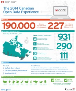
As part of their analysis, the authors also looked at the two Canadian Open Data Experience (CODE) hackathon events sponsored by the government in order to promote civic engagement with open data. Communications leading up to the events were provided in English and French. Government documentation also indicated strong participation from Quebec coders at the CODE hackathons, though native language of the coders is not indicated. Interestingly, the authors note, “In spite of the bilingual dimensions of CODE it has produced apps that are for the most part, English only.”

The 2015 event, which was sponsored by government but organized by a private company, had a bilingual website and application process. However, Scassa and Singh found that social media communications surrounding the event itself were primarily in English, including government tweets from the Treasury Board Secretariat. Given this, the authors question whether sufficient effort was made to attract French-Canadian minorities outside of Quebec, and if specific efforts may be needed to gauge and support digital literacy in these minority communities.

While it is still early days for Canada’s open data initiative, this case study serves to highlight the challenges of supporting an open data platform that can meet both legal obligations and broader ethical objectives. The authors conclude that, “In a context where the government is expending resources to encourage the uptake and use of open data in these ways, the allocation of these resources should explicitly identify and address the needs of both official language communities in Canada.”

Abstract

The open data movement is gathering steam globally, and it has the potential to transform relationships between citizens, the private sector and government. To date, little or no attention has been given to the particular challenge of realizing the benefits of open data within an officially bi- or multi-lingual jurisdiction. Using the efforts and obligations of the Canadian federal government as a case study, the authors identify the challenges posed by developing and implementing an open data agenda within an officially bilingual state. Key concerns include (1) whether open data initiatives might be used as a means to outsource some information analysis and information services to an unregulated private sector, thus directly or indirectly avoiding obligations to provide these services in both official languages; and (2) whether the Canadian government’s embrace of the innovation agenda of open data leaves minority language communities underserved and under-included in the development and use of open data.

Reference: Scassa, T., & Singh, Niki. (2015). Open Data and Official Language Regimes: An Examination of the Canadian Experience. Journal of Democracy & Open Government, 7(1), 117–133.

If you have thoughts or questions about this article, get in touch with Naomi Bloch, Geothink’s digital journalist, at naomi.bloch2@gmail.com.