Five Geothink researchers published a new paper in Transactions in GIS this past January that reflected on four years of research into how geospatial open data can impact the relationship between government, its citizens and the private sector.
By Drew Bush
In their article published this past January, five Geothink researchers reflected on four years of research into how geospatial open data can impact the relationship between government, its citizens and the private sector. In it, they examine how geospatial open data poses challenges for civic participation related to subsidizing the private sector, being provisioned equally across geography and user type, and in increasing corporate influence on government.
Published by Transactions in GIS, the article entitled “The Cost(s) of Geospatial Open Data” concludes with the development of critical questions to guide governments that provide open data in addressing costs related to constituency, purpose, enablement, protection, and priorities.
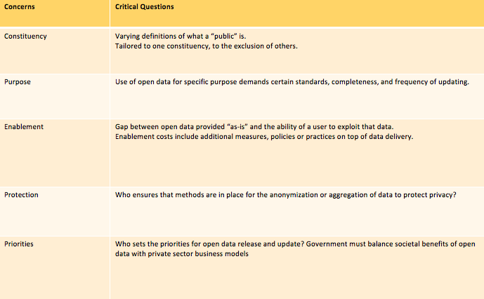
A key table from the “The Cost(s) of Geospatial Open Data” which lays out the critical questions in each of these areas for municipalities.
“What we were trying to do is to push the conversation of ‘value’ for open data beyond the typical areas of transparency, economic innovation, and service to citizens, and look more at what the generation of value can create in terms of additional costs,” Geothink Co-Applicant Peter Johnson, the paper’s first author and an associate professor in the University of Waterloo’s Department of Geography and Environmental Management, wrote in an e-mail. “So, for example, we talk about how there is a lot of interest in how open data can promote transparency, which is a great outcome. However, this can’t be conflated with more durable challenges like citizen participation and citizen engagement.”
“Simply putting open data out there won’t move the needle on those,” he added. “Rather, government must continue to work hard and use open data to help further those ends, but not as a replacement.”
Johnson’s co-authors on the paper were Geothink Principal Investigator Renee Sieber, associate professor in McGill University’s Department of Geography and School of Environment; Geothink Co-Applicant Teresa Scassa, Canada research chair in Information Law at the University of Ottawa; Geothink Collaborator Monica Stephens, assistant professor at The State University of New York, Buffalo; and Geothink Co-Applicant Pamela Robinson, the associate dean for Ryerson University’s Faculty of Community Services and an associate professor in the School of Urban and Regional Planning.
They note in the paper that their research funded by the Social Sciences and Humanities Research Council of Canada has evolved to examine the costs of open data that have emerged, and shown that “spatial is special” and that the broader open data research community that “draws upon a different set of assumptions and literatures, would benefit from the lessons learned in GIScience.” The paper then goes on to create “a framework that details direct and indirect costs created through the process of government open data provision, drawn from the perspectives of our key informants in municipal governments. Many of the indirect costs are external to the providing organization and are not always clear or straightforward.”
“Open data may enable a kind of smoke and mirrors that obscures a government’s actual commitment to citizen participation, transparency and accountability,” said Sieber. “The challenges of using open data as a platform for citizen participation and engagement can be exacerbated where insufficient government resources are deployed to ensure that open data sets are properly prepared for release.”
Johnson agreed.
“We are just holding our hands up and saying ‘Wait, this is more complicated than you think,’” he wrote. “Especially when we think of issues like protection of privacy for health or financial data, there are a lot of things to think through in parallel to just ‘How are we going to use (exploit) this data?’ So, for future research on this topic, I think that there is a lot to be done. Who is using open data and what are the ups and downs of using it?”
The Cost(s) of Geospatial Open Data
Abstract
The provision of open data by governments at all levels has rapidly increased over recent years. Given that one of the dominant motivations for the provision of open data is to generate ‘value’,both economic and civic, there are valid concerns over the costs incurred in this pursuit. Typically, costs of open data are framed as internal to the data providing government. Building on the strong history of GIScience research on data provision via spatial data infrastructures, this article considers both the direct and indirect costs of open data provision, framing four main areas of indirect costs: citizen participation challenges, uneven provision across geography and user types, subsidy of private sector activities, and the creation of inroads for corporate influence on government. These areas of indirect cost lead to the development of critical questions, including constituency, purpose, enablement, protection, and priorities. These questions are posed as a guide to governments that provide open data in addressing the indirect
###
If you have thoughts or questions about the article, get in touch with Drew Bush, Geothink’s digital journalist, at drew.bush@mail.mcgill.ca.