Category Archives: Academic Output

Geothink Award Winner’s Research Brings Focus to City of Kelowna’s Homelessness Plan and Services to Those in Need

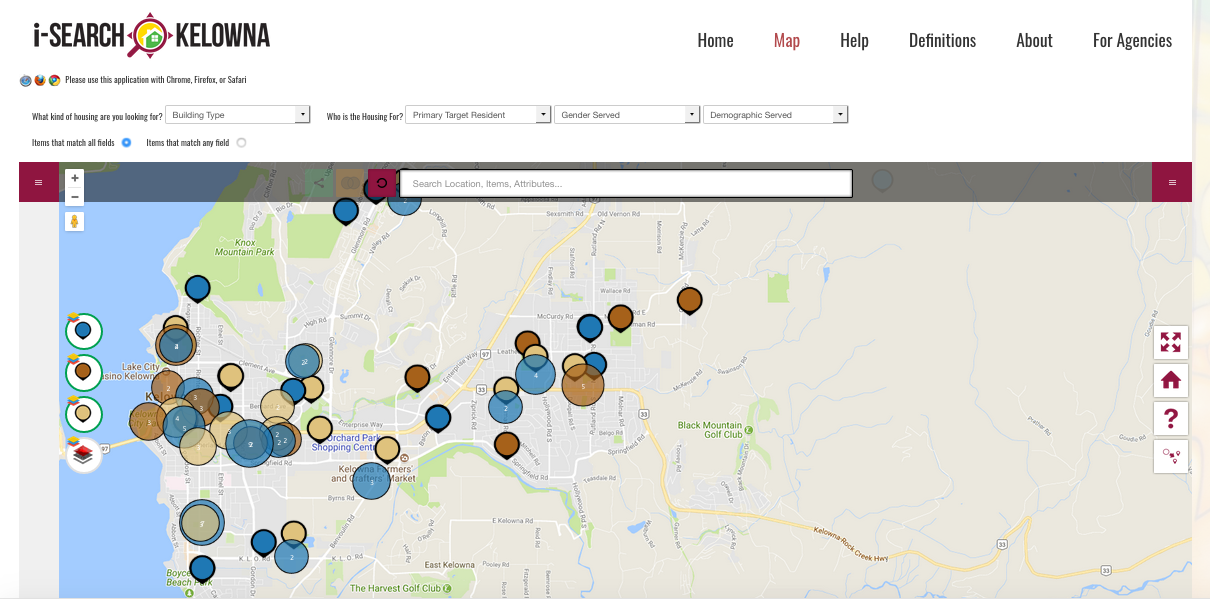
The iSearch Kelowna website is designed to assist individuals looking for low-income rentals, supportive housing or emergency shelters in the City of Kelowna.

By Drew Bush

One of the major challenge faced by anyone who finds themselves homeless involves finding shelter at places operated by a multitude of religious, goverment and nonprofit organizations. Thanks to the doctoral work of one Geothink student, that task just became a bit easier for those struggling with it in the City of Kelowna.

Shelley Cook, a Ph.D. Candidate at the University of British Columbia (UBC)-Okanagan, has worked with Geothink Co-Applicant Jon Corbett, an associate professor at UBC-Okanagan’s Department of Community, Culture and Global Studies, to design iSearch Kelowna. Via the app and website, individuals seeking low-income rentals, emergency shelter and drop-in services are able to search for live, user-specific information about resource availability within the city of Kelowna.

Shelley Cook, a University of British Columbia-Okanagan Ph.D. Candidate, developed the iSearch Kelowna site for her dissertation work.

“As we’ve moved out of phase one of our project, its morphing into another phase as it’s getting picked up as an important tool to inform this homelessness strategy, and people are running with it,” Cook said. In fact, this past summer the City of Kelowna decided to make iSearch Kelowna a central part of their strategy on homelessness. This highlighted Cook’s developing collaboration with the city on a project already supported by a team of reseachers, funders and partner organizations.

“It’s what we anticipated as what could happen and it’s lined up that way,” Cook said. “We’re maximising the benefit of the work that we’ve done, which is fantastic. It’s really in a strange way in its infancy, in terms of where it’s going to end up going, because it keeps evolving. So that’s been fantastic also.”

Cook’s work was recently recognized through Geothink’s first Dr. Alexander Aylett Scholarship in Urban Sustainability and Innovation (La Bourse Dr. Alex Aylett en Durabilité Urbaine et Innovation). The award was established in Aylett’s memory to provide vital support to graduate students sharing Aylett’s passion for, and commitment to, sustainable urban development.

Early feedback on iSearch Kelowna indicates that it is already providing users with a sense of ownership and advocacy over their own well-being and simplifying access to shelter information.

“It’s really about promoting empowerment, a greater sense of fairness and equity on the distribution of resources,” Cook said. “What we’ve done in terms of evaluation is directly talk to people who were formerly homeless or struggling with issues of maintaining adequate safe housing for themselves. That’s the one big thing they’ve talked about. And there’s lots of different elements around the interface that make it really usable and accessible.”

Speaking with Geothink during the Summer 2017 Summer Institute, Corbett added that issues of social and spatial justice motivate the research he and Cook have undertaken.

“There’s I think 84 different organizations that work on social justice related issues in and around the City of Kelowna,” Corbett said. “Which is kind of shocking because the population of Kelowna is only 185,000 people. So the fact that you’ve got 84 different organizations working is indicative of how serious the problem really is.”

He noted that the city and funding organizations for these services had started to notice that each individual service providers was acting in isolation. As a result, there was no centralized place to find specific services across the city such as a hot meal or housing if you are over 55-years-old.

The initial tool Corbett envisioned was going to be aimed at service-providers using real-time data to help coordinate where to send homeless people for specific services. That evolved as Corbett and Cook began discussing the project with the City of Kelowna. It now includes portals for a variety of different types of users—including the homeless themselves.

“For us, it’s been a whole set of reasonable technical challenges,” Corbett added. “But we’ve also been dealing obiviously with this very, very important social question.”

There are also endless applications for how the open data collected as a part of the project can make services more accessible and comprehensive for those in need. One worry has always been how to make what is a digital application accessible to a population that might not always have internet access.

“The main branch of the Kelowna library, a main point around Kelowna’s homeless community, has a dedicated monitor station during opening hours, is accessible for people to be able to search,” Cook said. “So it’s really about promoting service equity, and a greater sense of fairness and equity around the distribution of resources.”

“They now possess the knowledge,” she added of the homeless people using the site. “And what we know is they didn’t have the knowledge of all of [the city’s services]. So what that does is—the creating these forms of open data—opens up services to people and creates a more level playing field. Which is an incredibly powerful use of tools like this and was one thing that we weren’t necessarily anticipating.”

In the future, Cook plans to include more types of homeless services in the database and expand the site and offerings to other cities that have already expressed an interest in it.

“The final piece is an awareness raising and an ongoing partnership,” Cook said. “We’re doing presentations where communities have an interest in British Columbia and Alberta at this point. We can be of assistance in helping them develop a similar process and mentoring in that way.”

For Corbett and Cook, this means getting the project into the hands of city officials where it will live and exist for the community in perpetuity.

“So from the perspective of urban sustainability, we’re seeing municipalities, more so than in the past, getting involved with complex social issues like homelessness, and taking a lead role around these things,” Cook said. “Having a technological backbone that can help function not only to generate important information but to help people come together under a collective virtual umbrella. That’s a very powerful way to maximise and sustain existing community resources, and find innovative ways to create linkages and partnerships through tools and technology like iSearch Kelowna.”

###

If you have thoughts or questions about the article, get in touch with Drew Bush, Geothink’s digital journalist, at drew.bush@mail.mcgill.ca.

Geothink Student Shelley Cook Awarded Dr. Alexander Aylett Graduate Scholarship in Urban Sustainability and Innovation for Her Work Empowering Homeless Populations

Shelley Cook, a Ph.D. Candidate at the University of British Columbia (UBC)-Okanagan, will be the recipient of Geothink’s first Dr. Alexander Aylett Scholarship in Urban Sustainability and Innovation (La Bourse Dr. Alex Aylett en Durabilité Urbaine et Innovation).

By Sam Lumley

Shelley Cook, a University of British Columbia-Okanagan Ph.D. Candidate and the first Geothink Dr. Alexander Aylett scholarship recipient.

Shelley Cook, a Ph.D. Candidate at the University of British Columbia (UBC)-Okanagan, will be the recipient of Geothink’s first Dr. Alexander Aylett Scholarship in Urban Sustainability and Innovation (La Bourse Dr. Alex Aylett en Durabilité Urbaine et Innovation). Her project empowers homeless populations in the city of Kelowna by building new connections with homeless service providers such as community housing organizations.

“I think It’s hard for me to articulate how much it means to me,” Cook said of this honour. “I’m utterly blown away by the privilege.”

Cook’s research was recognized because it closely aligns with the late Dr. Aylett’s vision for urban sustainability. His legacy for creative and durable solutions to social justice issues in cities lives on in Cook’s work. Dr. Aylett passed away on July 23, 2016 from cancer leaving behind a rich legacy of research into how cities can provide solutions on topics such as climate change and social justice using digital technology and open data.

Geothink’s Dr. Alexander Aylett Scholarship in Urban Sustainability and Innovation was established in his memory, to provide vital support to graduate students sharing Aylett’s passion for, and commitment to, sustainable urban development.

“I think after spending my entire career working with extremely marginalized populations, I think it’s difficult work,” Cook said. “And it’s work that I’ve seen over the years—you know, people working with the most vulnerable in society—it’s work that’s often not acknowledged. So I think, for me, I’m utterly blown away by the privilege and the fact that it is for work that is helping people who are the most vulnerable in the community. And I just feel incredibly honored in that respect.”

The award recognizes exceptional research contributing to the field of urban sustainability, and represents one way in which Dr. Aylett’s work is continuing to generate innovative, far-reaching impacts.

“Alex was an exceptional person and his presence seems to continue to surround those who knew and loved him,” Richard Aylett, his father, said. “And so, it is important that an award in his name goes to a project of value.”

Alex’ family is equally honoured to award Cook’s research noting in a e-mail to Geothink that “her work on mapping resources for homelessness in British Columbia corresponds with volunteer work that Alex did for street youth in Vancouver and is thus very appropriate.”

Cook’s work addresses an important issue faced by many communities where homeless populations are not able to efficiently locate suitable temporary shelter. Housing seekers and service providers have often lacked access to centralised, searchable information on gender-specific services, housing location and capacity.

Geothink Co-Applicant Alexander C.E. Aylett who passed away July of last year.

To confront this problem, Cook developed the i-Search Kelowna web map application (app). Supervised by Geothink Co-Applicant Jon Corbett, an associate professor in Community, Culture and Global Studies at UBC-Okanagan, Cook’s work is also supported by a team of researchers, funders and partners. Via the app, individuals seeking low-income rentals, emergency shelter and drop-in services are able to search for live, user-specific information about resource availability within the city of Kelowna.

Early feedback on the tool indicates that it is already providing users with a sense of ownership and advocacy over their own well-being and simplifying access to shelter information.

“It’s really about promoting empowerment, a greater sense of fairness and equity on the distribution of resources,” Cook said.

The project mirrors past volunteer work undertaken by Aylett that supported marginalised communities and contributed to his vision of cities as thriving, safe, and inspiring places for everyone to live. These are all values which Cook shares in her own work.

Cook emphasizes that partnerships formed between researchers, municipalities, businesses and community members are crucial to the development and durability of the project. By deeply routing themselves in the community, the researchers have made sure that their work has progressed to meet evolving needs and issues.

“I think again diverse groups with common interests can come together and create something that benefits the broader community,” Cook explains.

“Homelessness takes different forms over time, so we needed to make sure this tool was responsive and continuously informing strategies and approaches to the long-term issues,” she adds.

In this respect, the project has so far enjoyed a large amount of success. The City of Kelowna has embraced the platform to not only provide housing services but to inform its homelessness strategies and decision-making processes.

The generous support from the Dr. Alexander Aylett Scholarship in Urban Sustainability and Innovation is invaluable for ensuring continued commitment to the idea of cities as sustainable and equitable sites for innovation and development.

###

If you have thoughts or questions about the article, get in touch with Sam Lumley, Geothink’s newsletter editor, at sam.lumley@mail.mcgill.ca.

Guide Provides Citizens Access to Open Data Literacy

The Geothink Citizen’s Guide for Open Data found at citizens-guide-open-data.github.io

By Drew Bush

Screenshot of the Geothink Citizen’s Guide to Open Data link on Geothink.ca.

You may have noticed a new banner gracing the front right portion of the Geothink.ca Web site starting last month. Click on it and it will take you to a key deliverable of this five-year partnership research grant funded by Canada’s Social Sciences and Humanities Research Council (SSHRC).

The Geothink Citizens Guide to Open Data was created by Curtis McCord and Dawn Walker, Geothink doctoral students in University of Toronto’s Faculty of Information, in collaboration with Geothink Co-Applicant Leslie Regan Shade, professor and associate dean for research in the faculty. It was first presented at Geothink’s 2016 Summer Institute at Ryerson University in Toronto when the duo were master’s students speaking on a panel.

“There’s actually still a big barrier where a lot of individual people aren’t using open data,” Walker said. “So we’re like in this moment, of saying, ‘Ok, open data has been lauded for all this potential promise.’ But it’s not exactly being used proportionally in the ways that are expected. From my experience, I’ve just seen a lot of companies or people who have very strong technical capabilities being able to work with open data. But there’s a lot of people who maybe have questions about their city or country that maybe open data can speak to. But like don’t—like wouldn’t even know to engage with it as a question you could ask of data. Or even know that open data would be a place they could go look to see.”

“These sorts of guides kind of help think about what those bridges could be,” Walker added. “And [they] address some of the literacies and capabilities required to even start to understand that you can ask questions that open data can answer.”

The Guide’s goal is to “provide citizens with tools to understand what makes up open data (OD), how it can be used in their communities, and where to find it.” Set up similarly to a Wiki page with drop-down menus, it consists of four sections on the right-hand bar entitled “Citizens Stories,” “Citizen Guide,” “Additional Resources,” and “About this Guide.”

The home page for the Guide notes that “People across Canada use technology that makes use of data as part of their daily lives” and increasingly are “starting to think about creative ways that this technology and data can be used to address issues they face in their communities and cities.” It adds that civic technology constitutes instances where “citizens come together to identify problems in their society or their community and solve them with data, computers, or expertise. Many kinds of data and their uses come up when we talk about open data and we’re going to know about them at the end of this guide.”

“It’s in no way kind of settled, right?” McCord said of the Guide. “We really intended this to be kind of a living document that people could update with their own stories or their own insights. We’re really open to ideas about how the kind of like stewardship of this thing might work. I mean, I’m much less committed to the content of the guide than I am to the idea that it can exist and be cared for. I’d rather it be everybody else’s ideas on their than mine. Because in a way, that shows it’s like kind of actually being put to work.”

McCord added that anyone interested in contributing can edit the guide by following simple instructions to use GitHub found at the bottom “Change This Guide!” link on the site. They can also e-mail the authors by clicking the “Feedback” link. Such contributions will represent the next step in the guide’s release to the public.

According to Shade, the first steps began directly as a result of her work with Geothink.

“The project began with my interest in exploring facets of data literacy, and more particularly with an interest in unpacking elements of open data for people and communities that were curious about it but not conversant with how to use open data,” she wrote in an e-mail. “Alexander Taciuk, our former [Geothink] Project Manager, was instrumental in encouraging me to pursue this project. And key to the project’s vision was the tremendous teamwork of Curtis McCord and Dawn Walker who worked on the Guide while finishing up their Master of Information degrees.”

“Curtis and Dawn wrote and designed the bulk of the Guide while also convening a small group within Geothink and locally to give advice on the content,” she added.

This year Shade engaged new students to continue work on several facets of the Guide including University of Toronto Master of Information students Dal Singh, Nicole Stradiotto and Mari Zhou and doctorate student Camille-Mary Sharp.

###

If you have thoughts or questions about the article, get in touch with Drew Bush, Geothink’s digital journalist, at drew.bush@mail.mcgill.ca.

Paper Spotlight: The Cost(s) of Geospatial Open Data

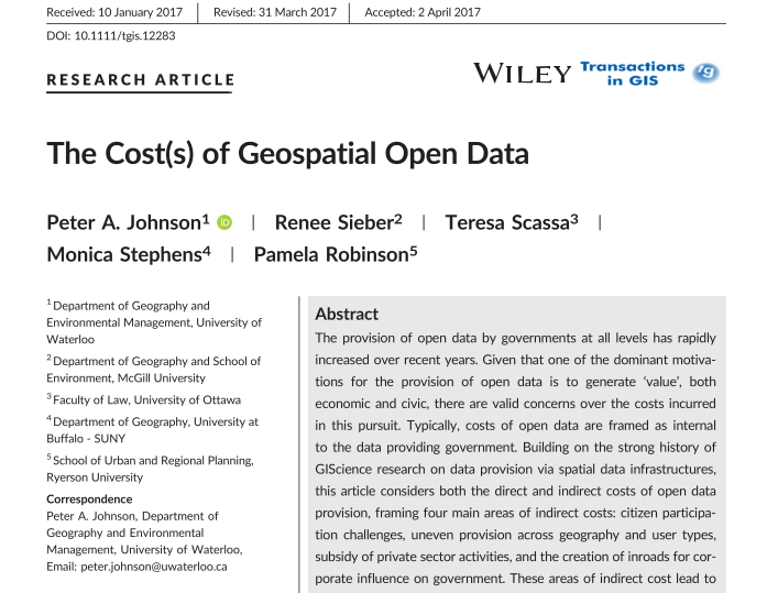
Five Geothink researchers published a new paper in Transactions in GIS this past January that reflected on four years of research into how geospatial open data can impact the relationship between government, its citizens and the private sector.

By Drew Bush

In their article published this past January, five Geothink researchers reflected on four years of research into how geospatial open data can impact the relationship between government, its citizens and the private sector. In it, they examine how geospatial open data poses challenges for civic participation related to subsidizing the private sector, being provisioned equally across geography and user type, and in increasing corporate influence on government.

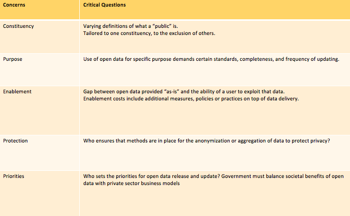
Published by Transactions in GIS, the article entitled “The Cost(s) of Geospatial Open Data” concludes with the development of critical questions to guide governments that provide open data in addressing costs related to constituency, purpose, enablement, protection, and priorities.

A key table from the “The Cost(s) of Geospatial Open Data” which lays out the critical questions in each of these areas for municipalities.

“What we were trying to do is to push the conversation of ‘value’ for open data beyond the typical areas of transparency, economic innovation, and service to citizens, and look more at what the generation of value can create in terms of additional costs,” Geothink Co-Applicant Peter Johnson, the paper’s first author and an associate professor in the University of Waterloo’s Department of Geography and Environmental Management, wrote in an e-mail. “So, for example, we talk about how there is a lot of interest in how open data can promote transparency, which is a great outcome. However, this can’t be conflated with more durable challenges like citizen participation and citizen engagement.”

“Simply putting open data out there won’t move the needle on those,” he added. “Rather, government must continue to work hard and use open data to help further those ends, but not as a replacement.”

Johnson’s co-authors on the paper were Geothink Principal Investigator Renee Sieber, associate professor in McGill University’s Department of Geography and School of Environment; Geothink Co-Applicant Teresa Scassa, Canada research chair in Information Law at the University of Ottawa; Geothink Collaborator Monica Stephens, assistant professor at The State University of New York, Buffalo; and Geothink Co-Applicant Pamela Robinson, the associate dean for Ryerson University’s Faculty of Community Services and an associate professor in the School of Urban and Regional Planning.

They note in the paper that their research funded by the Social Sciences and Humanities Research Council of Canada has evolved to examine the costs of open data that have emerged, and shown that “spatial is special” and that the broader open data research community that “draws upon a different set of assumptions and literatures, would benefit from the lessons learned in GIScience.” The paper then goes on to create “a framework that details direct and indirect costs created through the process of government open data provision, drawn from the perspectives of our key informants in municipal governments. Many of the indirect costs are external to the providing organization and are not always clear or straightforward.”

“Open data may enable a kind of smoke and mirrors that obscures a government’s actual commitment to citizen participation, transparency and accountability,” said Sieber. “The challenges of using open data as a platform for citizen participation and engagement can be exacerbated where insufficient government resources are deployed to ensure that open data sets are properly prepared for release.”

Johnson agreed.

“We are just holding our hands up and saying ‘Wait, this is more complicated than you think,’” he wrote. “Especially when we think of issues like protection of privacy for health or financial data, there are a lot of things to think through in parallel to just ‘How are we going to use (exploit) this data?’ So, for future research on this topic, I think that there is a lot to be done. Who is using open data and what are the ups and downs of using it?”

The Cost(s) of Geospatial Open Data
Abstract
The provision of open data by governments at all levels has rapidly increased over recent years. Given that one of the dominant motivations for the provision of open data is to generate ‘value’,both economic and civic, there are valid concerns over the costs incurred in this pursuit. Typically, costs of open data are framed as internal to the data providing government. Building on the strong history of GIScience research on data provision via spatial data infrastructures, this article considers both the direct and indirect costs of open data provision, framing four main areas of indirect costs: citizen participation challenges, uneven provision across geography and user types, subsidy of private sector activities, and the creation of inroads for corporate influence on government. These areas of indirect cost lead to the development of critical questions, including constituency, purpose, enablement, protection, and priorities. These questions are posed as a guide to governments that provide open data in addressing the indirect

###

If you have thoughts or questions about the article, get in touch with Drew Bush, Geothink’s digital journalist, at drew.bush@mail.mcgill.ca.
Augmented Reality in Real Life: Evaluating the Potential of New Digital Tools for Use in Municipal Planning Practice

By: Laura Brown, Natalia Dmuchowska, Brodie Johnson, Teresa Liu, Corinna Prior, Matthew Zentner

Pokémon Go was a phenomenon that swept the world this past summer. Cities around the globe experienced an influx of citizens into their public spaces as everyone tried to ‘catch-em-all.’ Crazed Pokémon trainers wandered the city swiping their phones and battling to win gyms, ultimately searching for the coveted Pikachu. The significance of these movements within the urban environment has been covered here.

The game is based on augmented reality (AR) technology that overlays a game world on top of a live map of the city, creating new ways for players to interact with the spaces around them. While other applications like Google Maps and Foursquare use similar technology, it was Pokémon GO that became the first game to achieve widespread success.

Over the last three months, a group of graduate researchers from the School of Urban and Regional Planning at Ryerson University also caught the PokéFever and sought to explore more serious aspects of the game. Working with clients from the City of Toronto Manager’s Office and Public Consultation Unit, their research investigates the challenges that municipalities face in working with new and emerging technologies and how urban planners might be able to use similar technology to consult and engage with the public. The potential of AR technology such as Pokémon GO to alter the behaviour of people in real space presents both opportunities to attract people to certain locations and animate space, as well as concerns regarding public safety and security, and inequities arising from disparities in access.

Pokémon GO Findings
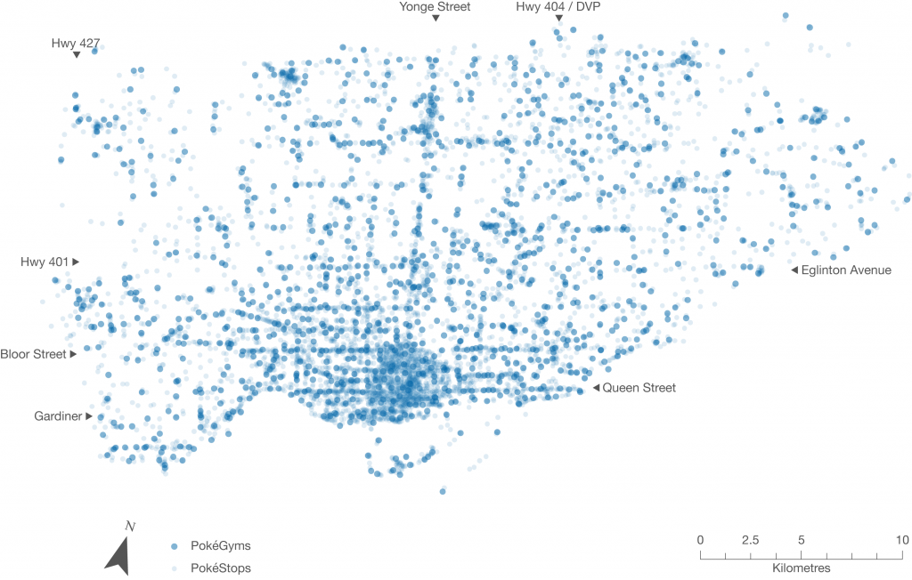
Conducting an exploratory analysis into the relationship between game data and demographic data, the team first investigated the distribution of PokéStops and PokéGyms throughout Toronto. In the game, PokéStops are locations where players receive items necessary for gameplay, and players may join one of three teams and “battle” for possession of PokéGyms. For their research, however, the team was interested in these landmarks as fixed locations that draw players to visit them in the real world. In addition, the locations of these markers were selected based on the Google database as well as player suggestions from a previous AR game by the same developer called Ingress. According to the developer, the markers that were frequented most by Ingress players became Gyms in Pokémon GO, and the others became PokéStops.

While 90% of people within the city lived within a five-minute walk of game elements, access varies significantly in terms of density, disproportionately making the game play experience much richer in the downtown core. Whereas overcrowding in open spaces and parks became the focus of media attention, there was actually a much higher concentration of game elements along major corridors like Queen Street. Narrowing our boundaries to just the downtown core, however, did reveal higher concentrations of gyms and stops in open spaces. These results were surprising and suggest the different forms that the public realm takes across the city.

Figure 1. Indicators of concentrated play spaces in the City of Toronto, as represented by the fixed landmarks in Pokémon GO (PokéStops and Gyms)

Public Realm
As we moved through our analysis, something meaningful emerged. We started to think about Stops and Gyms as indicators of concentrated play spaces. The map below depicts what happens when you remove the road lines – clusters of dots begin to reflect desire paths into areas of the public realm that were appropriated for game play. Rather than simply revealing the distribution of the game throughout the urban fabric, the placement of the Stops and Gyms hint at the fine-grained spaces that interconnect more formal “Open Spaces” across the city. This may contribute to a more nuanced view of the public realm, in addition to the more obvious areas defined by parks and open spaces.

Figure 2. PokéStops and Gyms in the City of Toronto, without road lines

Because many of the Stop and Gym locations were user generated and determined on the basis of usage (based on Niantic’s previous AR game Ingress), they may serve as indicators of where players might want to linger and occupy the public realm, as well as landmarks that hold cultural significance. While we recognize that this data only reflects a segment of the public, we think it might be possible for city planners to use this data in their analyses of streetscapes and cultural heritage, to better visualize existing public assets. Further it provides insight into how citizens use spaces in the city.

Augmented Reality and Planning
Current public consultation and engagement practices with citizens and stakeholders are predicated on in-person interaction, although they are increasingly occurring through online and other platforms. AR technology can draw people to new spaces and change the way they move around the city. Harnessing AR could bring new opportunities for reaching different demographics in the places where they live, work, and play.

We looked at the potential of using augmented reality technology to enhance development proposal signs through geo-location and visualization. Imagine walking down a street and receiving a notification on your smartphone for a nearby development proposal. By clicking it on it, the user is guided to the location where they are shown a visualization of the project conveniently through their phone. This would provide more meaningful information about the size and scale of the project, allowing people to see the full extent of the proposal in human scale and in context, while reviewing specific details right then and there.

Figure 3. Application of AR technology for visualization of a development project. Source: Augment

Finally, augmented reality can be used as a platform for public education and collaboration between community groups to enhance heritage planning and the public realm. This could potentially transform the whole city into a new type of living museum without borders, inspiring people to feel greater ownership over the city and its heritage.

Evaluating Technology for Planning
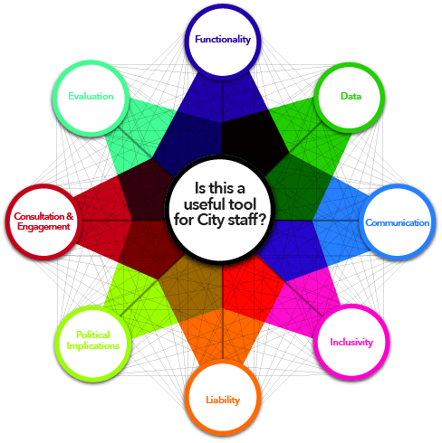
It is also necessary to understand how emerging technologies are created, implemented, and used. We have created an evaluative framework that explores the different areas planners must be aware of when evaluating new technology, an overview of which is shown in the figure below. These include the technical aspects and requirements (such as the platform of the technology), opportunities for greater engagement (ways to break down barriers like language and visual or auditory impairment), and potential inequalities and liabilities (such as data security concerns and differing abilities to access technology). Most importantly, this assessment allows planners to determine the usefulness of a technology in their daily planning practice.

Figure 4. Evaluative framework for planners for examining new technologies

The continually changing world of technology creates new opportunities that have the potential to enhance the way people interact with their city and the processes that govern it. We feel that planners are well placed to harness these emerging technologies to augment their cities in real life.

Although the Pokémon craze has since died down, it provided us with a unique opportunity to discover the potential of emerging technologies. We look forward to seeing what the future has in store for cities and for urban planners.

The full evaluative framework and results from the Pokémon GO analysis will be posted to the Geothink website shortly.

For more information please feel free to contact us at teampokeplan@gmail.com. Team PokéPlan is comprised of Laura Brown, Natalia Dmuchowska, Brodie Johnson, Teresa Liu, Corinna Prior and Matthew Zentner.

Thank you to our supervisor and Geothink co-applicant Dr. Pamela Robinson (Ryerson University, School of Urban and Regional Planning) and our clients at the City of Toronto!

On the Hunt for Social Justice and Empowerment

By Logan Cochrane, Mark Gill, Jon Corbett

The participatory geoweb has the potential to transform relations of power – who contributes and names places, what is excluded and labeled. This transformation can occur through newfound opportunities for engagement and giving voice to spatially relevant issues. In the 1990s, GIScience recognized this potential and made explicit the importance that social issues would, and should take within the discipline and practice. Geothink did likewise, making social justice one of its key themes. While Web 2.0 and the geoweb has promised greater forms of equality, particularly through supporting user generated content, we know that maps remain value-laden, and are embedded with particular power relations that are not necessarily equally distributed. Social justice is a term that describes the equitable distribution of resources, opportunities, and privileges within society. Amidst the Web 2.0 enthusiasm, we were interested in how issues of social justice are being addressed within the context of the geoweb in academic literature. You might be surprised what we found.

We first set out to take stock of the current state of GIScience literature (Cochrane et al, 2016). Using the ten most highly ranked academic journals by GIScientists. We assessed ten years of literature. We narrowed the more than 14,000 articles published from 2005 to 2014 to those having some relationship to the geoweb and/or crowdsourcing, using broad and inclusive terms. Of the resulting sub-set, we searched for social justice, and terms related to it, for example empowerment. We found that only three articles engaged explicitly with social justice . Even more surprising, terms related to social justice (empowerment, marginalization, social change, environmental justice, spatial justice, etc), were limited to the marginal periphery of these top tier journals. In other words, these ideas tended not to be the main content of the research. We argue that GIScience runs the risk of missing important insights , as mapmakers around the world are engaged in practice, but ignored in top tier GIScience journals.

Finding that social justice was more likely to be a footnote than a substantial focus of the research endeavour or engagement, we then wondered about empowerment. We had searched for it in the original article, but wanted to expand the search (adding ten more years of journals, 1996-2014, and using an open search rather than specific journals) and go into more detail (Corbett, Cochrane and Gill, 2016). Empowerment is of particular interest for GIScience because so many assume the use of the participatory geoweb results in empowerment. While the usage of the term has increased with time, the concept was consistently ill-defined and insufficiently measured. Amazingly, almost one quarter (24%) of the articles that mentioned “empowerment” were not included in the main text, but in places such as the works cited list or an endnote. Even of those that did engage with the concept in a substantial way, only a minority defined the term, fewer still explained how they measured it, and only five listed the specific metrics. We argue that researchers should make a greater effort to adequately define what they mean by “empowerment” and provide a way to actually assess how projects are providing that particular empowerment.

These two papers act as key reference points for those interested in the participatory geoweb. While our papers do not negate the potential for positive impacts, they highlight the fact that research commonly does not engage with social justice, and when terms like empowerment are used, they are often not defined or cannot justify claims of positive impact. As Web 2.0 technologies encourage people to take part in creating knowledge, through maps or otherwise, we need researchers to study how participatory and crowdsourcing approaches to map making intersect with issues of social justice. Based on these findings, we hope to draw attention to this important aspect of GIScience which has long been identified as a crucial area of research.

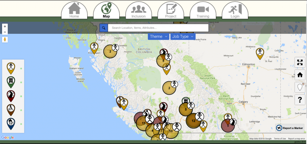
Dr. Corbett's research team are tackling issues of empowerment via the geoweb and have developed tools such as GeoLive

Dr. Corbett’s research team are tackling issues of empowerment via the geoweb and have developed tools such as GeoLive

For more information, see the two papers this post was based on:
Cochrane, L., Corbett, J., Evans, M. and Gill, M. 2016. Searching for Social Justice in GIScience Publications. Cartography and Geographic Information Science http://dx.doi.org/10.1080/15230406.2016.1212673

Corbett, J., Cochrane, L. and Gill, M. 2016. Powering Up: Revisiting Participatory GIS and Empowerment. The Cartographic Journal http://dx.doi.org/10.1080/00087041.2016.1209624

Paper Spotlight: Fostering Citizen Trust in Municipal Government

Screen Shot 2016-08-15 at 8.56.32 AM

A new IMFG Perspectives paper posit five steps to foster citizen trust in Canadian municipalities.

By Drew Bush

In a new article, Geothink Co-Applicant Pamela Robinson and her co-author, Dina Graser, posit five steps to foster citizen trust in Canadian municipalities as they attempt to raise funds to cope with almost $400 billion of infrastructure deficit nationwide.

Pamela Robinson is an associate professor at Ryerson University’s School of Urban and Regional Planning.

Pamela Robinson is an associate professor at Ryerson University’s School of Urban and Regional Planning.

Published by the Institute on Municipal Finance and Governance (IMFG) at University of Toronto’s Munk School of Global Affairs, A Recipe for Fiscal Trust (No. 13) reviews literature on public trust in government. In September, the authors will host a seminar to elaborate on their work. (Check back here for details when they become available.)

“There’s no shortcuts,” Robinson, an associate professor at Ryerson University’s School of Urban and Regional Planning, said of the paper. “We have to stop thinking about civic engagement and relationship building between local government and members of the general public as discreet events and things that you tick-off, ‘Like, ok, I’ve done that.’ There are—the ways in which relationships are built and maintained and nurtured and cultivated is the active work of government.”

She sees this research as building upon previous Geothink research examining the ways in which civic hackathons reshape citizen-government interactions along with open data. Instead of interrogating how open data makes municipalities more accountable or transparent (or may fail to), this paper examines how it shapes levels of public trust in government. Robinson adds that data itself is not a panacea.

“Data is an input into our process but the data itself won’t give you trust or transparency,” she said. “You have to use the data embedded in broader processes of civic engagement. And so the portal is just the beginning—it’s not the end.”

Robinson warns that the longer municipalities wait to build trust and raise funds, the greater the challenge will be in terms of the huge backlog of municipal infrastructure work that needs to be completed. Particular challenges include governments strapped for resources and money, news cycles with shorter attention spans, and citizen fatigue with governmental processes. Yet, new transit lines or bridges require sustained community engagement.

“Not only is the process of maintaining good citizen-local government relationships really important and hard work,” Robinson said. “It’s going to require more and more attention. And it can’t be just that thing that those people over there do. It needs to be internalized.”

Find the executive summary and citation for the article below:

Citation
Graser, D. & Pamela, R. (2016) A Recipe for Fiscal Trust. IMFG Perspectives, No. 13, p. 1-20.

Executive Summary
Cities across Canada face an enormous infrastructure deficit. From 100-year-old water mains to transit systems in vital need of upgrading and expansion, Canadian infrastructure is widely recognized to be in dire straits. And while the majority of Canadians elected a new government that was prepared to run a deficit to fund infrastructure, these funds alone will not cover the investments needed.

Local governments need to make significant financial investments, too, and must raise revenues through taxes, user fees, and possibly new revenue tools. But before they can take these actions, they have to build trust to convince heir residents that new revenues are needed and will be spent wisely.

What does it mean to build trust? This paper examines the notion of trust and how governments can build it using:

  • Good information: relevant data made accessible to citizens and attractively packaged to enhance transparency;
  • Good communications: good stories that are well told, with relevant information distributed through a variety of channels (using open government tools and techniques);
  • Good engagement: inclusive and meaningful opportunities for dialogue about policy decisions to build the continuum of trust (using a variety of mechanisms);
  • Credibility: building an effective track record and controlling costs (through better performance benchmarking and other approaches);
  • Earmarking of funds: creating a dedicated fund that clearly links revenues raised to specific expenditures, and regularly reporting on the progress of projects funded.

This research shows that there are concrete and practical steps that cities can take to build fiscal trust – but there are no shortcuts. Trust-building is a long-term proposition that takes resources. Cities must invest the time and dedicate the resources to build trust through all of the steps outlined, and continue to do so as part of their regular activities.

Paper Spotlight: Examining Urban Reasoning Skills in the Age of Digital Cities

Smart citizens

Smart citizens of the future must develop the skillsets required to understand spatio-temporal interactions in dynamically linked urban networks of places according to Geothink Co-Applicant Stéphane Roche (Photo courtesy of http://www.i2cat.net/sites/default/files/smart-city.jpg).

By Drew Bush

In a paper published this past May, Geothink Co-Applicant Stéphane Roche posits that emerging smart cities require citizens to develop an urban intelligence that meshes material realities with digital information. In order to fully manage and engage with urban spaces, future smart citizens must develop the skillset required to understand spatio-temporal interactions in dynamically linked urban networks of places.

Stéphane Roche is a professor and vice dean of research for the Faculty of Forestry, Geography, and Geomatics at the University of Laval (Photo courtesy of www.scg.ulaval.ca).

Entitled Geographic information science III: Spatial thinking, interfaces and algorithmic urban places-Toward smart cities, the paper was published in Progress in Human Geography. Roche, a professor and vice dean of research for the Faculty of Forestry, Geography, and Geomatics at the University of Laval, has previously written two papers on the subject. The series of papers defines urban intelligence, the importance of spatial reasoning in smart cities, and the organization of digitally enabled cities.

“Most of the resources that are today available in order to help people to move in the city, are available—are digitally available,” Roche said. “[Yet] at the same time, mobility in the city is really grounded in the materiality. If you need to walk or if you need to take your bike, it’s an active kind of mobility. And if you don’t really know perfectly the places where you need to travel, you need to have the minimum capability to access information from different kinds of interfaces. Through your phone, through the Internet, through a different kind of display available in the city for example.”

Transportation presents but one case study for examining the integration of digital technology into physical urban places. Roche expands on this interaction to further define place as consisting of three elements: 1) A geographical location; 2) An event (such as an accident, festival, or meeting); and 3) A name. This, of course, means that two separate places could involve the same physical space but at different times.

As you may imagine, this type of insight takes time to develop. After reflecting on the existing literature in the field, along with his own previous work, Roche begins his first paper, Geographic Information Science I: Why does a smart city need to be spatially enabled? by emphasizing the importance of Geographic Information Science (GIS) to smart cities. He argues that the smart city is first and foremost a spatially enabled city.

His second paper, Geographic information science II: Less space, more places in smart cities, Roche advances the idea that modern cities consist of networks of connecting places, amends the very definition of place, and posits urban intelligence as the capability to understand how urban places are created and how they interact. Finally, his most recent third paper comes full circle to question why people who have developed urban intelligence necessarily also employ spatial learning and reasoning skills.

“Actually, what I’ve tried to do in this report is probably link what I define as the urban intelligence,” he said. “That means the capability of someone, people, or a group to understand the urban dynamic by using spatial skills and spatial thinking abilities. That means making the link between different components of the urban environment. So this is what I define as the urban intelligence. The capability of understanding what’s happened at the specific time and specific place.”

“The aim, ok, is to say in our current modern environment, there are multiple opportunities and tools and approaches that could help humans to improve their spatial thinking ability,” he added. “And these improvements will be more and more required if people want to engage. That means they will, there is no way to keep them engaged without spatial thinking abilities in this kind of new urban environment where everything is connected. Where everything is based on dynamic fluxes and mobilities. So if you are not able to understand how those dynamics work, you will have more and more difficulty in getting grounded in the place where you live.”

Please find links and abstracts to each paper mentioned in this article below:

Abstract 1
Geographic Information Science I: Why does a smart city need to be spatially enabled?
In this report I propose to examine the concept of the ‘smart city’ from the standpoint of spatial enablement. I analyse emerging research on smart cities, particularly those addressing the potential role of GISciences in the development and implementation of the concept of smart cities. I develop the idea that the intelligence of a city should be measured by its ability to produce favourable conditions to get urban operators (citizens, organizations, private companies, etc.) actively involved into sociospatial innovation dynamics. To obtain such a commitment, I believe that operators should be able to develop and mobilize (digital) spatial skills so that they could efficiently manage their spatiality. In other words, I argue that a smart city is first of all a spatially enabled city.

Abstract 2
Geographic information science II: Less space, more places in smart cities
This second report is dedicated to the concept of ‘place’ revisited in the context of smart cities. Some recent studies suggest that today’s digital cities rely more on an approach to the urban context based on a network of connected places than on an approach to the city built on areal spaces. Does it mean that there are more places and fewer spaces in spatially enabled cities? Is the intelligence of a city mainly related to its ability to sound out the genesis of urban places? These issues raise questions about the design of spatial models used to build GIS, as well as place-based urban design methods and tools. This second report explores these questions from the standpoint of GISciences.

Abstract 3
Geographic information science III: Spatial thinking, interfaces and algorithmic urban places—Toward smart cities
This third report examines interfaces as a key element enabling spatial skills, and development of new forms of digital spatialities for smart cities. Digital technology is becoming consubstantial to urban materiality, but map interfaces are particularly central tools for indexing (geographic) knowledge and expertise, accessing informational components of digital cities, and actively engaging digital dimensions of urban places.

If you have thoughts or questions about the article, get in touch with Drew Bush, Geothink’s digital journalist, at drew.bush@mail.mcgill.ca.