Author Archives: Geothink

PhD students at work in GeoThink – Harrison Smith

Read Harrison’s biography athttp://www.fis.utoronto.ca/students/harrison-smith I am a third year PhD student at the University of Toronto’s Faculty of Information (http://www.fis.utoronto.ca).

My research is broadly oriented around geo-locative social media and consumer surveillance to theorize new practices of social sorting and digital discrimination within mobile and cartographic information infrastructures. My PhD thesis specifically researches geo-locative and mobile based dating services due to their significant investment in collecting and analyzing personal information, as well as their emphasis on creating affective relationships with surveillance databases. I have worked as a research assistant broadly situated within political economy and surveillance studies. For this project I will be researching the political economy of the geoweb under the direction of Dr. Leslie Regan Shade. This project research will focus on the institutional forces and power relations at play within geoweb infrastructures. The forces and relations will show up largely through understanding the processes of ownership, control and labour, as well as considering alternate forms of geoweb applications that might transcend private sector models. I am very excited to be part of this project, and hope to continue researching mobile and geoweb infrastructures as a core part of my academic research interests.

Admin Note: This research is in Theme 6, the political economy (www.britannica.com/EBchecked/topic/467600/political-economy) of the geoweb, but you can see many of our themes will overlap. Harrison’s research will have aspects related to Theme 3, on law and public policy related to the geoweb, especially where it concerns privacy. It is difficult to talk about the political economy without acknowledging the huge privacy implications of placing so much of our personal information on the web and being able to mine that and other datasets. This is a challenge to be faced by society at large and for governance at all levels of government. We’d appreciate your thoughts on this research and would welcome your participation. Please email harrison [dot] smithatmail [dot] utoronto [dot] ca or leslie [dot] shade [at] utoronto [dot] ca.

Accuracy, Authenticity and Technical Aspects of Privacy

At the Universities of Laval and Waterloo, we are interested in what is often seen as the “virtuous cycle” of citizens’ increasing use of open government data and, potentially, for governments to actively leverage information that the public creates. Our work centers on issues of accuracy, authenticity and privacy in citizen-generated spatial data and the changing relationships between governments and citizens in data provision and use. In Year 1, we are concentrating on assembling baseline information that will help us understand how citizens use open data from governments and the extent that Canadian governments’ currently leverage citizen-contributed data. In this first phase, we will assemble a literature review and survey government partners at local, provincial and national levels to:

  1. Identify and characterize the main current open data initiatives (e.g., who is providing what data, in which forms?) and what data standards are used at local and provincial levels (if any?),
  2. Identify existing as well as potential practices for: a) using crowdsourced data (including barriers and opportunities) and, b) for validating crowdsourced data,
  3. Explore the linkages between open data (as a product and as practice) and crowdsourcing at the municipal and provincial levels (e.g. open data not only a service provided by the organization but also a way to improve data and by feedback loops in practice).

Two PhD students (Ashley Zhang – Waterloo, Teriitutea Quesnot – Laval) have been hired to jointly complete the literature review, survey administration and analysis and also participate in reporting the results through a journal paper. Teriitutea Quesnot is from French Polynesia. Teriitutea received his bachelor and masters in France and he has strong geocomputing and programming skills as well as consulting experience. Ashley is from China and has completed her Masters at the University of Georgia with a thesis focus on exploring spatio-temporal changes in the sociao-spatial structure of Beijing. Currently, her PhD research is centred on public engagement and place-making in smart cities. Since our government partners operate in both English and French, the survey will be bilingual to allow a pan-Canadian assessment to be developed. This information relating to current opportunities and barriers will help us develop new methods for promoting and visualizing data authenticity and accuracy. We anticipate that it also will contribute to project-wide efforts to develop best practices for Canadian governments to manage citizen-generated in light of data privacy and quality concerns.

We know that many of our partners and others have considerable experience in utilizing crowdsourced data. Even if you don’t then you probably have questions you’d like explored.

We encourage you to get in touch with us to enrich our research. Feel free to email stephane.roche@scg.ulaval.ca and robert.feick@uwaterloo.ca.

Hopping the Geofence: A Quick Look at Geofencing Practices

By Matthew Tenney

As we walk, drive, or skip down the road most of us are actively sharing bits of information about ourselves to anyone who cares to listen. The piece(s) of mobile technology we carry with us, nearly ever place we go, is being bombarded by a field of sensors that hear where and who we are.  Often these sensors can talk back to us through emails, SMS, or many other mediums directly to our smartly connected pockets. What they are looking for and what they do with this information is, however, a complex system of applications that vary depending on the kinds of hardware being used to what purpose someone has for listening in the first place.

Strategies known as geofencing utilizes location based services (LBS) within certain geographic zones and are delineated by sensor networks across real-world geographic areas. These invisible fences act as both partitions and catchment areas, which quiet heavily used in today’s digital world whether you are aware of it or not.

One example of geofencing is for commercial enterprises like consumer centers and dissemination of marketing materials. A shopping center can create a radius of interest (or guesstimated trade area) around their locations and “watch” all of those that enter and exit via different LBS. Sometimes these fences will alert you with an ad about their big fire-sale on paperback books, or, maybe extend an exclusive deal to you for: being in the right place, at the right time.

Another popular use of geofences is for safety and security purposes. Acting in this case, more like their traditional counterpart, as a barrier between different places or people. Digital Childcare services can offer a means to track the real-time whereabouts of children and provide different levels of safeguard measures to send alerts when these borders are crossed. Some high-security facilities can take advantage of geofences both inside and outside of buildings. When sensitive materials are at risk geofences can act as an invisible alarm systems that protects both digital and physical materials from leaving authorized areas.

Civic and community organizations have also been using geofences. School and college campuses offer geofences for secure network access to things like student records and other services. Sporting events can send real-time alerts to fans out in the parking lot about the game. Neighborhoods provide community wide Wi-Fi to residents or visitors and share community events. Residents can also use these geofenced zones as if they were mirroring physically gated-neighborhoods and extend heartfelt welcomes – or stern warnings – to those that enter its perimeter.  The state of Texas in the U.S. also sends out SMS alerts to automobile drivers on the interstate system about accidents, missing persons, or other public-service and emergency announcements.

For social networking, geofences can provide an intranet of connections between people that occupy the same geographic location. Providing a means to share messages to peers and outsiders about events and activities, geofencing, can allow people to form co-located digital cliques based on similarities of interest and location. |=|A|+|B|-|A∩B|
Figure 1: Inclusion-exclusion principle of mathematics. For illustrative purposes only. After all, everyone loves a good equation now and again.

While geofencing carries with it plenty of straightforward advantages, it is by definition a procedure of separating people, places, and things through processes of inclusion and exclusion. These processes, be they engineered or naturally formed, define more than just geographic regions, but also claim people, services, and resources via the quick and ready use of widespread modern technologies.

| A∪B|=|A|+|B|-|A∩B|
Figure 1: Inclusion-exclusion principle of mathematics. For illustrative purposes only. After all, everyone loves a good equation now and again.

Social exclusion refers to processes in which individuals or groups of people are blocked from rights, opportunities and resources (e.g. housing, employment, healthcare, civic engagement, democratic participation and due process) that are normally available to members of society and which are key to social integration. Where social inclusion is the opposite processes of offering these things to people and places that they belong.

There is apparent risk of geofencing to be an updated version of redlining, a process of discrimination that isolated certain people by socio-demographic traits like race and class, that dynamically dictate membership of “now you’re in, now you’re not” instantaneously.

A geofencing community can lay claim to another geographic area or alter its boarders as needed to grab a few people here and cut a few over there out. This can both create territorial bounds for community and individual identities and destroy the reputation of others. Social elitists can demarcate the newest hip-scene to be seen in and can at the same time kick to the curb outdated venues or areas as yesterdays hangout spots.

The implications of this rapid construction and destruction of identities has yet to be fully understood, but one can wonder what will the Brooklyn of tomorrow look like? Or, better yet: where will it be tomorrow and who is “in” now and “out” like yesterday?

In order to understand, promote, and prevent the right-and-wrong outcomes of geofencing requires a deeper understanding of what kinds of information is being shared, who is using it, and for what purposes. While technology shows no sign in abating the amount of digital information that can be shared through LBS, geofencing is an inevitable concern for all of us. Whether on onside of the digital divide or another, geofencing will likely define how we understand concepts of the city and ourselves in the future.

Canada’s Open Government Licence V2.0 Is Released


Written by Teresa Scassa

Read more posts by Teresa @ http://www.teresascassa.ca/

With little fanfare, the Canadian government has released its much awaited, newly revised Open GovernmentLicence. The previous version that had been available on its Open Data site was a beta version on which public comments were invited. The government has also published its Open Government Licence Consultation Report, which summarizes and discusses the comments received during the consultation process.

The revised version of the licence is an improvement over its predecessor. Gone is the claim to database rights which do not exist in Canada. (These rights do exist in the UK, the Open Government Licence of which was a template for the Canadian licence). The new licence also discards the UK term “personal data” and replaces it with “personal information”, and it gives this term the meaning ascribed under the federal Privacy Act. The language used in the licence has been further simplified,making it even more accessible.

It should be noted that Alberta’s new open government licence – released as part of the launch of its open government portal earlier this year – is very similar to V2.0 of the federal government licence. There are some minor formatting differences, and a few changes in wording, most of which can be explained by the different jurisdiction (for example, the definition of “personal information” refers to Alberta’s Freedom of Information and Protection of Privacy Act). The similarities between the two licences are no coincidence. Although the Alberta licence was made public prior to the release of the federal government’s V2.0, work has been going on behind the scenes to move towards some form of federal/provincial consensus on the wording of open government licences with a view to ensuring that there is legal interoperability between data sets released by different governments in Canada. The efforts to reduce barriers to interoperability (whether legal or technical) are important to the ability of Canadians to work with and to integrate different data sets in new and innovative ways. Thus not only is the COGL V2.0 to be welcomed, so are the signs that cooperation and coordination may lead to a greater legal interoperability of open government licences across Canada.


Get to know Geothink

By Matthew Tenney

We live in a hyperlocal world, using geospatial technologies in which we contribute, share, and visualize information about our location and activities. Using technologies like Google Maps and GPS-enabled cellphones, individuals tweet about potholes; their mobile apps deliver directions to the nearest coffee shop, whose reviews were contributed by individuals. Governments add to the geographic data stream by increasing accessibility of their data, like real time transportation information. The new mobile forms of map making, called the Geospatial Web 2.0, are important to Canada’s and could regain our lost ground as a world leader in map making and geographic technologies and lead government practices into the future. The emergence of these tools and services provides new capabilities for both non-experts and governments to collectively contribute–to crowdsource–geographic information to a host of social, economic and environmental challenges. The widespread accessibility of these capabilities is significant because it blurs distinctions between user and producer of geographic information and allows citizens to volunteer geographic information with their locations and experiences.

Geothink is a 5-year partnership research grant funded by SSHRC and is one of only 20 grants awarded this year. The initiative is composed of 26 researchers and 30 partners, that range from city officials, business leaders, and academics across Canada. Our primary focus is on the implications of increasing two-way exchanges of geographic information between citizens and governments and the way in which technology shapes, and is shaped by, this exchange.

The primary goal of Geothink is captured in five broad objectives as
follows:

1) Identify best practices development and usage of Geoweb in government

2) Explicate paths for local governments to leverage the Geoweb to
communicate directly with concerned parties.

3) Investigate the social, economic and legal forces shaping means of
governance.

4) Establish a sustainable partner network of regular communication in
which ideas are bottom up and dynamically refined.

5) Train the next generation of leaders who will be highly technically
competent and cognizant of impacts of Geoweb technologies on governance
processes and citizen relationships.

As the grant progresses we will share necessary information for people to better understand and use these technologies for future projects and hopefully lead to significant changes in government practices in light of the research produced by the Geothink team.

We also would like to invite both cities and citizens to participate in any of the activities of Geothink including suggestions on how best to use these new digital technologies and the kind of data that would be most useful to provide.

Geothink ‘Meetup Montreal’

By Matthew Tenney

The Geothink Canada “meetup” took place last night (26 June 2013) that started with an overview of the grant by Professor Stéphane Roche from the Université Laval. Participants of the meetup ranged from university professors and students to city officials and representatives from Open Street Map (OSM). With such a diverse group of attendents individual interests and curiousities took the lead in guiding the evenings discussions.

A variety of topics were discussed that spotlighted both the many
troubles we will certainly face, as well as the range of benifits that could spur from such a comprehensive research initative regarding open-data and -government practices across Canada.

Topics that were covered ranged from overcoming the digital-divide,
engaging participation from marganilized communities, data-quality and provenance, and of course legal issues encompassing the dissemination of data.

Pleased by the turn out of the “meetup”, we look forward to the next one and hope to see you come out to be heard (be it in the flesh or a digital presence).

Stack Exchange Kicks Off New Open Data Forum – Check It Out!!

By Matthew Tenney

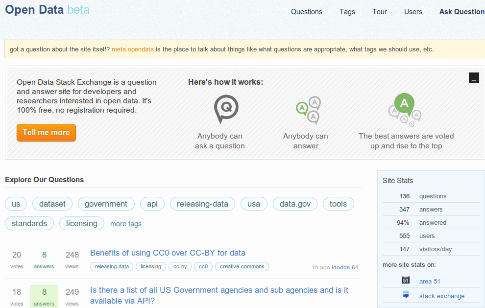
“Open Data Stack Exchange is a question and answer site

for developers and researchers interested in open data.

It’s 100% free, no registration required.”


http://opendata.stackexchange.com/


For those of you familiar with Stack Exchange already it is a pleasant sight to find the new Open Data forum online. If you are just now becoming acquainted with the site, welcome to a community of active and knowledgeable individuals where you can further hone your Open Data chops!  Open Data - Stack Exchange Beta is up and running!

Open Data – Stack Exchange Beta is up and running!

While the site is just budding, it has already seen an impressive number of stimulating questions and is carrying a 94% answered rate! Not only will you have leading experts in the fields of computer science and spatial technologies the new Open Data forum welcomes experts in participation, organizational, and data theory.

The range of questions and depth of answers is also driven totally by YOU! So don’t hesitate to post, comment, and answer question with this great resource for those of us interested in Open Data.

http://opendata.stackexchange.com/

Explorations In Geoweb – The Important Relationship Between Geoweb and Open Data

The Geoweb (related to open data) depends on open data to remain functional and accurate. This relationship functions in reverse as well, in that the support, use, and maintenance of open data can depend on Geoweb applications. One of the factors that influence public support is the perception of use and accessibility of the data. Without public support, open data projects will neither be funded nor maintained. Geoweb applications allow for practical application of open data that have high utility and value for citizens.

The City of Edmonton is a good example of the utilization of an open data portal as well as Geoweb applications on their website. The main page allows for you to browse various data sites and includes direct links to interactive maps and apps that make use of the data. While it is still very limited in terms of GIS capabilities (it just has some querying capability), it is still a step forward from simply viewing and downloading data. The City of Edmonton’s data portal development was commissioned to the open data platform company Socrata (the portal can be found here: https://data.edmonton.ca/).

There is statistical data that emphasizes the importance of the relationship between Geoweb and open data in a survey that was conducted in 2010 by Socrata. This company conducted an online survey of a total of 1000 citizens, a number of developers, and also municipal governments in the United States over a three month period in 2010 (http://www.socrata.com/benchmark-study). The results delivered a picture of the state of open data in the United States along with factors influencing success present and future.

The survey confirms that transparency, accountability and public participation in government are important to citizens, and consequently to governments who value public  opinion. Governments  who recognize that open data can affect the daily lives of citizens, and that this motivated them to initiate an open data project were in the majority of those surveyed (see Socrata Benchmark Study). Also, open data projects encouraged a positive attitude towards politicians and government as 61.0% of citizens surveyed, stated that they are more likely to vote for a politician who supports the development of Open Data and 56.3% stated they would trust their governments more if they made most of their data available online. These two factors alone show that citizens have a progressive mindset with regards to open data and that this is something that citizens want from their government. Government employees who were surveyed showed a much greater support for open data than citizens, 92.6% believed that public data should be made accessible online, 91% believed government data is public taxpayer property and should be made available free to all citizens.
The motivation and the support exist internally and externally, all that is missing is a standardization or organization for governments to allocate more resources to developing these projects.
The largest obstacle, according to the study, was lack of leadership from within the government to launch or to organize themselves for development.  The survey showed that the greatest motivation for open data initiatives at the Federal level was compliance to legislation or executive mandate. Mandates and regulation works for getting the ball rolling, overcoming the obstacle of ground up initiative, and so more of it needs to be seen to get smaller departments and organizations up to speed.  Thus the challenge to governments at all levels is to close the gap between the early and late adopters. One solution may be public awareness. The survey recorded that more than 60% of citizens surveyed did not have awareness of open data initiatives from their governments at all, which means that the majority of people don’t even know that open data is available to them. Getting the open data portals more exposure would lead to greater expectations and pressure from members of the public to increase the capacity, quality and development of open data. Citizens must know that there is a value to this data, and public awareness is a more complicated issue when not every citizen understands the benefits of it.

The success of a data portal then, and the success of its exposure to citizens, depends greatly on the ease of use to citizens, beyond being downloadable and readable. According to the information collected:

With respect to accessing data, citizens, by a 3 to 1 margin, prefer exploring and interacting with data online (63%) to downloading it in a spreadsheet (16%). As a matter of fact, downloading data, which is currently the most prevalent consumption method of government data ranked much lower than browsing pre-made visualizations (37%) or data discovery through social interactions and community feedback (29%). (Socrata Benchmark Study 2010).

Synthesized, organized and utilized information is more attractive to users than raw data alone and therefore has greater value and utility. Development of Geoweb applications need to be encouraged by governments or citizen groups through hackathons or other incentives in order to address the problem of both awareness with respect to the existence of the data portals, its utility to citizens and for governments making the budgets, the dollar-for-dollar value to invest in maintenance of the projects and increase funding and/or support.

Another important  issue and obstacle, is that the data that is available is often not deemed to be sufficient by developers to produce Geoweb applications, and thus data quality needs to be addressed in priority. Without voluntary developers for the Geoweb applications, development of Geoweb becomes expensive to governments and is also less efficient. Greater than 50% of developers surveyed do not believe that the data available is sufficient to develop a wide range of functional apps. More specifically, the needs identified by developers surveyed for efficient use of data were the right data (56.7%), open API (50%) and access to meta data, data quality (46.7%).

The Geoweb and open data have evolved to be dependent on one another for success, and the development of Geoweb applications is a key factor in the success of open data projects for governments. Regulation, public awareness, and data quality are amongst many variables that must be addressed by governments, and functional and valuable Geoweb applications can ease this for them.

To view the Socrata Benchmark Survey results, visit https://benchmarkstudy.socrata.com/. The written report is downloadable upon request at http://www.socrata.com/benchmark-study/