In this final issue we celebrate the culmination of five years of successful Geothink
research and present reflections from our faculty and staff.
We also catch up with Geothink Co-Applicant Leslie Shade, former Geothink student Edgar Baculi, and 2017 Geothink Summer Institute attendees Local Logic.
If you have feedback or content for the newsletter, please contact the Editor, Sam Lumley.
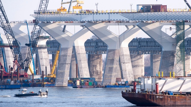
A new bridge is currently under construction next to Montreal’s Champlain Bridge. With Local Logic’s innovative approach, future planning decisions about bridges could be informed through detailed analysis of their impact on surrounding roads and neighborhoods.
By Drew Bush
When Local Logic co-founder and CEO Vincent Charles Hodder stopped by Geothink’s 2017 Summer Institute last year at McGill University in Montreal, QC, his presentation was a highlight for many of the students, faculty, and staff in attendance. Hodder’s company applies an innovative approach to improving the policies and practices of governments and their citizens through the use of urban geospatial data and modeling.
“We call ourselves urban planners turned data scientists,” Hodder told Geothink last summer. “So we’re really at the intersection of planning, data, data science, and then technology.”
Hodder told students his company was born out of his master’s work in McGill University’s School of Urban Planning and collaboration with students and faculty. At the time, the Canada Social Sciences and Humanities Research Council (SSHRC) Geothink partnership grant did not exist. But it would have been quite useful during his studies, he noted.
“Having people think about these issues while they’re in school I think is really important,” Hodder said. “And I think there is a lot of space for innovation in terms of cities, in terms of smart cities, and in using technology and having an impact on cities. So much so that we actually started a Meet-Up group in Montreal called Cities and Tech.”
Hodder and his colleagues have done more than start this group. His company has more than 15 full-time staff—including a former Geothink student. In the past few years, Local Logic has also expanded on its initial contributions to improving how urban development takes place or citizens choose their lodging. (His company’s approach allows you to know things like if your next prospective host on Airbnb might be located on a quiet or noisy street.)
Local Logic’s new ventures have moved beyond private real estate to focus on impacting municipal and urban planning and policy. He argues that his company stands at a crossroads. Their task is to redefine how governments create and present physical projects and accompanying policies so that individual citizens will better understand the impacts on their own lives.
“A lot of times these very large investments in public transportation, for example, are hard to understand for the citizen because it’s really difficult to kind of see the concrete impact on your life and on your daily activities,” Hodder said. “So, using our data we’ll be able to bring it down to that level of analysis and really see the difference in terms of, you know, housing values, lifestyle, and access to specific modes of transportation.”
“[Local Logic] mak[es] it much easier for people to understand the type of impact it will have on their lives,” he added. “For them, the citizens, to be able to make better decisions on whether or not to support these initiatives.”
Hodder’s company takes urban geospatial data collected in cities from now ubiquitous sensors and digital technologies such as smartphones. From this data, he and his colleagues work to painstakingly build models of urban spaces. This work starts with each individual street segment. On each street segment, coders must input all types of attributes relevant to a given project. These might include the width of streets, the height of buildings, the tree canopy, or how streets connect to adjoining infrastructure.
The resulting model has held a 94 percent confidence rate when applied to practical situations. It has been used to determine how best to place Bixi Bike locations in Montreal and to help housing developers better understand the needs of their potential customers. Future work may even evolve to include decision-makers in the federal government.
“We thought, what if we applied this way of analyzing the city to these kind of more macro issues as well,” Hodder said. “And then we realized there was this huge opportunity and there’s all this data available.”
Check out a video of Local Logic Co-Founder and CEO Vincent Charles Hodder talking at the 2017 Geothink Summer Institute in the second half of this video also featuring SmartHalo Co-Founder Xavier Peich.
Take a not-so-hypothetical situation as an example. Imagine one day that city officials in Quebec City and surrounding regions are planning a new bridge to cross from the North Shore to the South Shore of the Saint Lawrence River. Wouldn’t it be beneficial for governmental officials and their citizens to know how an automobile bridge versus one meant for bus rapid transit or rail affects traffic in surrounding neighborhoods and roads?
Local Logic’s effort to bring together academic researchers and stakeholders (who use technology to tackle urban problems) reflects an aim shared with the now concluding Geothink partnership research grant. The company’s work mirrors many of the lessons learned by Geothink’s researchers, students, and nonprofit, industry, and municipal partners. This helped to make Hodder’s presentation last summer quite compelling.
“It’s exciting to say,” he said. “But maybe we’ll have a real impact on the ways that cities are actually being built.”
###
If you have thoughts or questions about the article, get in touch with Drew Bush, Geothink’s digital journalist, at drew.bush@mail.mcgill.ca.
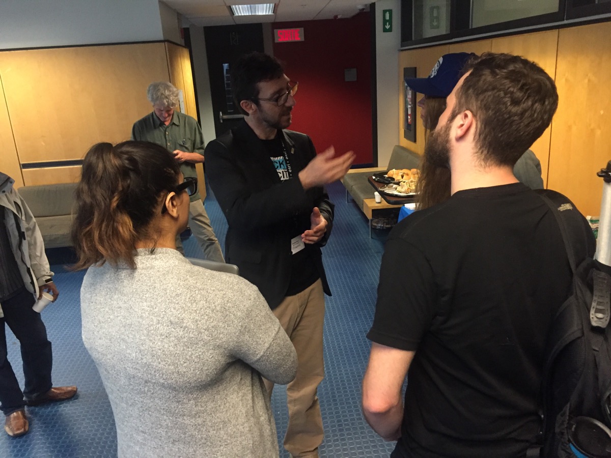
Geothink Co-Applicant Stéphane Roche, associate professor in University Laval’s Department of Geomatics, chats with students during a coffee break at Geothink’s 2017 Summer Institute at McGill University in Montreal, QC.
By Drew Bush
One of the hallmarks of any academic conference are the conversations that take place in-between sessions, in hallways and over meals. In our third Geothink Conversations, we aim to give you a flavor of these discussions at Geothink’s now concluded 2017 Summer Institute.
The theme of this year’s Institute was “Smart City: Toward a Just City.” An interdisciplinary group of faculty and students tackled many of the policy, legal and ethical issues related to smart cities. Each of the three days of the Summer Institute combined workshops, panel discussions and hands-on learning modules that culminated in a competition judged by Montreal city officials and local tech entrepreneurs.
The topic of our conversation was how to make sure human concerns remain paramount in the design of increasingly digital smart cities. It features Open North Executive Director Jean-Noé Landry; Geothink Co-Applicant Stéphane Roche, associate professor in University Laval’s Department of Geomatics; and, Victoria Fast, an assistant professor at University of Calgary’s Department of Geography. And, of course, I’m Drew Bush and I’ll be helping steer the conversation along.
To start us off, Roche got the conversation rolling on how to understand smart cities as a transition from urban living as it has been portrayed since the early 18th century to a new type of city based upon social organization and community that is aided by open data and digital technology.
By: Laura Brown, Natalia Dmuchowska, Brodie Johnson, Teresa Liu, Corinna Prior, Matthew Zentner
Pokémon Go was a phenomenon that swept the world this past summer. Cities around the globe experienced an influx of citizens into their public spaces as everyone tried to ‘catch-em-all.’ Crazed Pokémon trainers wandered the city swiping their phones and battling to win gyms, ultimately searching for the coveted Pikachu. The significance of these movements within the urban environment has been covered here.
The game is based on augmented reality (AR) technology that overlays a game world on top of a live map of the city, creating new ways for players to interact with the spaces around them. While other applications like Google Maps and Foursquare use similar technology, it was Pokémon GO that became the first game to achieve widespread success.
Over the last three months, a group of graduate researchers from the School of Urban and Regional Planning at Ryerson University also caught the PokéFever and sought to explore more serious aspects of the game. Working with clients from the City of Toronto Manager’s Office and Public Consultation Unit, their research investigates the challenges that municipalities face in working with new and emerging technologies and how urban planners might be able to use similar technology to consult and engage with the public. The potential of AR technology such as Pokémon GO to alter the behaviour of people in real space presents both opportunities to attract people to certain locations and animate space, as well as concerns regarding public safety and security, and inequities arising from disparities in access.
Pokémon GO Findings
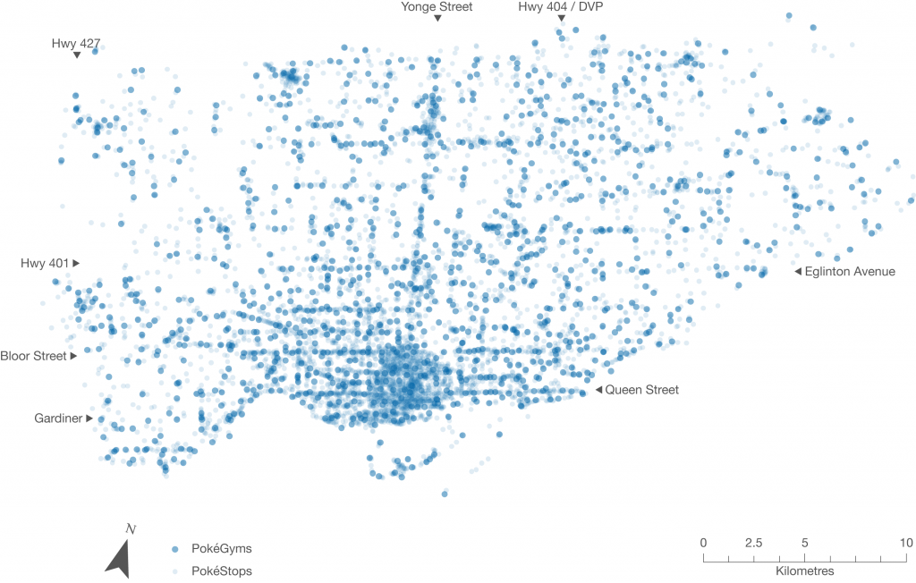
Conducting an exploratory analysis into the relationship between game data and demographic data, the team first investigated the distribution of PokéStops and PokéGyms throughout Toronto. In the game, PokéStops are locations where players receive items necessary for gameplay, and players may join one of three teams and “battle” for possession of PokéGyms. For their research, however, the team was interested in these landmarks as fixed locations that draw players to visit them in the real world. In addition, the locations of these markers were selected based on the Google database as well as player suggestions from a previous AR game by the same developer called Ingress. According to the developer, the markers that were frequented most by Ingress players became Gyms in Pokémon GO, and the others became PokéStops.
While 90% of people within the city lived within a five-minute walk of game elements, access varies significantly in terms of density, disproportionately making the game play experience much richer in the downtown core. Whereas overcrowding in open spaces and parks became the focus of media attention, there was actually a much higher concentration of game elements along major corridors like Queen Street. Narrowing our boundaries to just the downtown core, however, did reveal higher concentrations of gyms and stops in open spaces. These results were surprising and suggest the different forms that the public realm takes across the city.
Figure 1. Indicators of concentrated play spaces in the City of Toronto, as represented by the fixed landmarks in Pokémon GO (PokéStops and Gyms)
Public Realm
As we moved through our analysis, something meaningful emerged. We started to think about Stops and Gyms as indicators of concentrated play spaces. The map below depicts what happens when you remove the road lines – clusters of dots begin to reflect desire paths into areas of the public realm that were appropriated for game play. Rather than simply revealing the distribution of the game throughout the urban fabric, the placement of the Stops and Gyms hint at the fine-grained spaces that interconnect more formal “Open Spaces” across the city. This may contribute to a more nuanced view of the public realm, in addition to the more obvious areas defined by parks and open spaces.
Figure 2. PokéStops and Gyms in the City of Toronto, without road lines
Because many of the Stop and Gym locations were user generated and determined on the basis of usage (based on Niantic’s previous AR game Ingress), they may serve as indicators of where players might want to linger and occupy the public realm, as well as landmarks that hold cultural significance. While we recognize that this data only reflects a segment of the public, we think it might be possible for city planners to use this data in their analyses of streetscapes and cultural heritage, to better visualize existing public assets. Further it provides insight into how citizens use spaces in the city.
Augmented Reality and Planning
Current public consultation and engagement practices with citizens and stakeholders are predicated on in-person interaction, although they are increasingly occurring through online and other platforms. AR technology can draw people to new spaces and change the way they move around the city. Harnessing AR could bring new opportunities for reaching different demographics in the places where they live, work, and play.
We looked at the potential of using augmented reality technology to enhance development proposal signs through geo-location and visualization. Imagine walking down a street and receiving a notification on your smartphone for a nearby development proposal. By clicking it on it, the user is guided to the location where they are shown a visualization of the project conveniently through their phone. This would provide more meaningful information about the size and scale of the project, allowing people to see the full extent of the proposal in human scale and in context, while reviewing specific details right then and there.
Figure 3. Application of AR technology for visualization of a development project. Source: Augment
Finally, augmented reality can be used as a platform for public education and collaboration between community groups to enhance heritage planning and the public realm. This could potentially transform the whole city into a new type of living museum without borders, inspiring people to feel greater ownership over the city and its heritage.
Evaluating Technology for Planning
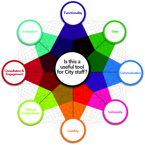
It is also necessary to understand how emerging technologies are created, implemented, and used. We have created an evaluative framework that explores the different areas planners must be aware of when evaluating new technology, an overview of which is shown in the figure below. These include the technical aspects and requirements (such as the platform of the technology), opportunities for greater engagement (ways to break down barriers like language and visual or auditory impairment), and potential inequalities and liabilities (such as data security concerns and differing abilities to access technology). Most importantly, this assessment allows planners to determine the usefulness of a technology in their daily planning practice.
Figure 4. Evaluative framework for planners for examining new technologies
The continually changing world of technology creates new opportunities that have the potential to enhance the way people interact with their city and the processes that govern it. We feel that planners are well placed to harness these emerging technologies to augment their cities in real life.
Although the Pokémon craze has since died down, it provided us with a unique opportunity to discover the potential of emerging technologies. We look forward to seeing what the future has in store for cities and for urban planners.
The full evaluative framework and results from the Pokémon GO analysis will be posted to the Geothink website shortly.
For more information please feel free to contact us at teampokeplan@gmail.com. Team PokéPlan is comprised of Laura Brown, Natalia Dmuchowska, Brodie Johnson, Teresa Liu, Corinna Prior and Matthew Zentner.
Thank you to our supervisor and Geothink co-applicant Dr. Pamela Robinson (Ryerson University, School of Urban and Regional Planning) and our clients at the City of Toronto!
In this episode, we take a look at two Geothink researchers who are investigating how the popular video game Minecraft can be used to improve local and regional planning processes. In particular, we talk with Ryerson University Gold Medal award winner Lisa Ward Mathers, and Ryerson master’s student Jacky Li. Both have worked with Geothink Co-Applicant Pamela Robinson, associate dean in Ryerson University’s School of Urban and Regional Planning.
“We also wanted to build, how do you say, just an open web kind of thing where you can log on and start building away at the city of Toronto. So the vision was to have all of Toronto built in Minecraft and that’s where I came in. I tried to—they hired me to get the program up and going. But I didn’t know how to start. So my research basically consisted of how we would do something like this.”
That’s Ryerson University Master’s Student Jacky Li talking about his work with Minecraft. Li is a student with Geothink Co-Applicant Pamela Robinson, associate dean in Ryerson University’s School of Urban and Regional Planning. Last summer, he interned with the City of Toronto’s Office of the Chief Planner.
Minecraft isn’t so much a game but rather a destination, a technical tool, and a cultural scene all rolled into one program. Children who use it can engineer complex machines; model the world in cube-like form; shoot and post YouTube videos of their work; and setup servers where they can hang out with their friends. The software, initially launched by Mojang (a Swedish game studio) in 2009, now boasts more than 100 million users. Microsoft recently bought it and Mojang for a record $2.5 billion.
“So I looked at examples of, in Sweden, they had really good one with between the architects and the government where they just focused on a suburb and they had users go in and start building. And then last summer, the graduating class of Niagara College [in Welland, Ontario] translated some GIS data into Minecraft. And I contacted them and they taught me how to do it.”
“Yeah so, at the end of it what I made for the city of Toronto was a report that said how to build like the sub-server thing, how to host it, and some potential programming they can do with children such as like a floor area ratio exercise where you can imagine density. So if you’re given solar power, how many blocks can you build different kinds of built forms depending on the criteria of the exercise . Yeah and just stuff like that.”
Li grew up as part of the Minecraft generation. For him, “It’s just a popular computer game where you basically craft things. It’s kind of like Lego, but on your computer, or on your Xbox or PlayStation, or on your mobile phone.”
His work was inspired by another student at Ryerson who wrote a report for the City of Toronto on the educational potential of a tool such as Minecraft that engages students with sometimes complex computer science in an immersive environment. Li is not alone in Geothink as a researcher working to determine how Minecraft can empower communities in urban planning decisions.
“From there I asked them specifically about different contexts within which Minecraft could potentially be used. Different scales, like for instance, a committee of adjustment or, you know, larger scales from there like an official plan review. I’m sort of asking what do you think, would this work in this context. What are your sort of initial impressions?”
That’s Lisa Ward Mather on her master’s research project she completed in 2014 at Ryerson University also with Robinson. She’s describing her work interviewing 12 planning officials to determine the usefulness of Minecraft for those working in regional and local urban planning.
In 2014, she graduated as the recipient of the Ryerson Gold Medal for her thesis work that was cited for combining academic proficiency with community engagement in a meaningful way.
“It wasn’t an interview with Minecraft experts by any means. A few of my respondents had encountered the game in a very, you know, not very intensive setting. I mean no one had really sat down and played extensively. But luckily Minecraft is a not a terribly difficult thing to explain to someone, especially with visuals. And I was able to get some really interesting observations from the people I spoke to.”
Her project interrogated whether planners felt open to using Minecraft and whether they thought it would engage the public. She also asked what possible benefits and obstacles they foresaw in specific applications. Her findings largely showed that it could be a useful tool for engaging the public in planning decisions, but obstacles such as it’s cost as well as the cost of equipment needed to support it could limit use.
Mather’s work did not stop after her graduation.
“I was in communication with a staff member from the office of the chief planner at the city of Toronto. And they, as you know, they are interested in trying new tools and using new tools in different ways, and engaging people in ways maybe they’re not used to being engaged. And so they were interested in seeing what could be done with the game.
“So, we, after some discussion, concluded that one possibility would be to have them send me some SketchUp files, Google SketchUp files, of a corridor in Toronto. And to produce a Minecraft world that had both what that corridor looks like right now, what it would like in the near future when there are more mid-rise buildings lining the sides of the streets, and then the in the far future when the entire corridor is lined with mid-rise buildings. So, I, after a fair amount of experimentation, and, uh, and this is something I had never done before. So I looked at what various tools that were available online and I was able to produce those three models within the same Minecraft world.”
“And I built a little rail car down the middle of the street so that the user rode from the present to the near future and then to the far future. And I made a movie of that which then they played at an event that they were holding from the Office of the Chief Planner.”
This small project has opened interesting possibilities for the City of Toronto to engage citizens with a unique tool like Minecraft. From Sweden to Canada, the Minecraft generation may one-day grow up to design the cities of the future.
[Geothink.ca theme music]
[Voice over: Geothoughts are brought to you by Geothink.ca and generous funding from Canada’s Social Sciences and Humanities Research Council.]
###
If you have thoughts or questions about this podcast, get in touch with Drew Bush, Geothink’s digital journalist, at drew.bush@mail.mcgill.ca.
Minecraft users envisioned the City of Stockholm in Sweden the way they wanted it to be using the popular game.
By Drew Bush
When the New York Times recently ran a ten page magazine story on The Minecraft Generation, it focused primarily on young users learning basics of computer science through their engagement with this software. For two Geothink researchers, harnessing youth enthusiasm for this tool is also central to helping cities make better planning decisions.
For the un-initiated, Minecraft isn’t so much a game but rather a destination, a technical tool, and a cultural scene all rolled into one program. Children who use it can engineer complex machines, model the world in cube-like form, shoot and post YouTube videos of their work, and setup servers to hang out on with their friends.
The software launched by Mojang (a Swedish game studio) in 2009 now boasts more than 100 million users. Microsoft recently bought it and Mojang for a record $2.5 billion.
Lisa Ward Mather studied Minecraft’s possible application to urban planning as a master’s student with Geothink Co-Applicant Pamela Robinson, associate dean in Ryerson University’s School of Urban and Regional Planning. In 2014, she was recognized for community engagement in her thesis work with a Ryerson Gold Medal.
“It was basically an exploratory study, sort of, where I went and spoke to planners and engagement specialists and asked them to what degree and in what context they thought that Minecraft could be a useful tool for planners to use for engagement,” she said. “I interviewed twelve people and came up with some really rich responses, actually.”
Many of the experts she spoke with during her master’s research project were senior-level and had not necessarily had much, if any, experience actually working with the Minecraft program. To ensure they adequately understood the software, Mather created a video that explained the game, what it looked like and the various activities users could undertake. The video also featured unique projects.
“Such as something called Blockholm,” Mather said. “Which was, in the city of Stockholm, they brought in infrastructure related to Minecraft. And then they allowed or gave away plots of land within the Minecraft city for people to build what they thought the city should be. It was a project that was sort of a visioning project. And they ended up building things in real life and having a museum exhibit that people could wander around in.”
Educating Young Students in the Virtual Minecraft City of Toronto
Mather is not alone in researching the power of Minecraft to empower communities in urban planning decisions that can affect their daily lives. For an internship at the chief planner’s office with the City of Toronto, another one of Robinson’s students, Jacky Li, helped the city initiate an educational program that envisions the entire city built in Minecraft.
A master’s student from the University of Ryerson had written a report on how using Minecraft might be effective as an educational and planning tool for work with young children. For his own work during the summer of 2015, Li assessed the technical challenges the city would need to overcome to engage students in the school system in envisioning complete communities through Minecraft.
He describes the software as a “popular computer game where you basically craft things.” It’s analogous to “Lego,” he said, “but on your computer, or on your Xbox or PlayStation, or on your mobile phone.”
Li examined examples in Sweden of architects and city planners collaborating to better design a suburb and learned from users at Niagara College in Welland, Ontario how to translate GIS data into the program.
“At the end of it what I made for the city of Toronto was a report that said how to build like the sub-server, how to host it, and some potential programming they can do with children,” Li said. “Like a floor-area ratio exercise where you can imagine density. So if you’re given solar power, how many blocks can you build different kinds of built forms on depending on the criteria [of the power].”
The Minecraft Generation Becomes Today’s City Planners
Minecraft not only engages users with its simple design in educational settings but also in envisioning how to plan for future changes in a city. Both Mather and Li ask practical questions about the utility of a program like Minecraft beyond its entertainment value.
Mather’s master’s set the stage by asking planners about the obstacles and benefits to Minecraft to determine contexts in which such software might be useful. Since the conclusion of this work, she’s also found interest in her work from the chief planner’s office at the City of Toronto.
In a recent project she tested her own skills with Minecraft—something she had not done previously. The city sent her Google SketchUp files of a corridor in Toronto that she used to produce a Minecraft world. In particular, she created a 3-D model of what the corridor looked like now, in the near future with more mid-rise buildings and in the far future when it’s lined with such buildings.
“It was not a detailed world in the sense that the building didn’t have windows and stuff like that,” she said. “Because it was just a model that came from Sketchup, it was not a very detailed, the file I brought in was not, did not have that kind of nuance to it. Of course, bringing, the complexity of bringing something into Minecraft is you can’t necessarily determine the kind of material it’s made out of. Every individual part of the building would be the same material. So I ended up with a stone world, of the corridor and surrounding buildings.”
Even so, she found this small project very interesting and hopes to continue the work. Such research embraces the potential of new media in improving urban planning decisions. (For more, see our story on using open data to revolutionize urban planning decisions.)
If you have thoughts or questions about this article, get in touch with Drew Bush, Geothink’s digital journalist, at drew.bush@mail.mcgill.ca.
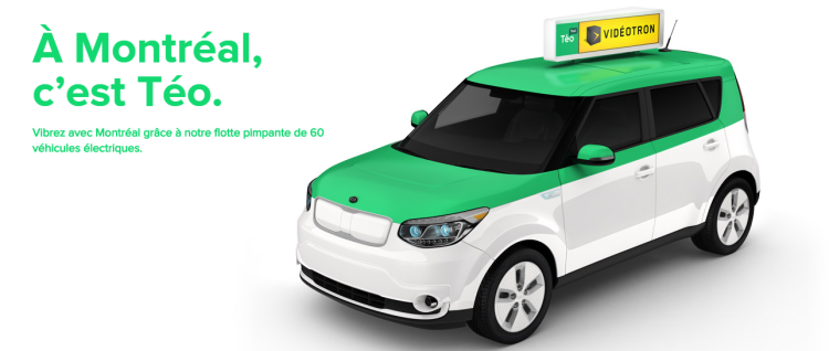
Clean electric Téo taxi will be coming to Montreal in coming years following its investment in the city.
Climate change, in combination with the urban heat island effect, is expected to exacerbate current warming trends in urban areas that will impact human health.
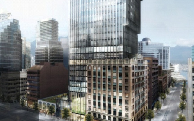
An artist’s rendering of the new Exchange tower – a LEED-certified project in Vancouver that was integrated into the restored Old Stock Exchange building. Canada and Vancouver in particular have been recognized for leadership in green building.
By Drew Bush
Imagine a world where electric taxis crowd Montreal’s downtown streets, green buildings efficiently manage energy consumption for Vancouverites, and Toronto’s city leaders monitor differences in neighbourhood surface heat emissions to best position green roofs. Now imagine the environmental and social impacts of such shifts when scaled-up for all of Canada’s cities.
That future—one that makes use of digital technology, citizen-sensors, and open data to manage urban areas more sustainable—may already be here according to some experts. In coming years, the company Téo taxi will bring the first fleet of electric taxis to Montreal’s streets while Hydro Quebec has also begun work to bring thousands of electric charging stations to the province of Quebec.
Globally, changes triggered by digital technologies and open data have already begun to impact how city leaders make decisions and engage with communities on environmental issues. One outcome of these new mediums for exchanging information has been enhanced capacity of cities to use citizens and resources to strategically tackle issues such as climate change.
“I think it will be a noticeable difference on the streets of Montreal when you walk out and you see the white and green Téo taxis you know all through the downtown core,” said Geothink researcher Alexander Aylett, a professor and researcher at the Institut national de la recherche scientifique. “You know we’re talking about a really large pool of electric vehicles. And the shift is an environmental one, but it’s also a social and a cultural one where people start to have direct experience with electric mobility. It will be really profound.”
Aylett noted that 40 percent of Montreal’s greenhouse gas (GHG) emissions derive from moving people and things around the city. Efforts to scale-up the ability of cities across Canada to manage and change truck, car, and train traffic is one of several goals city leaders across North America are pursuing, he added in a recent interview with Geothink.ca.
“So instead of just having one city that’s really strong in transit and another city that’s really strong in green buildings, we are seeing a shift—I think it’s a slow shift but I think we’re headed in that direction—where cities are approaching sustainability and trying be leaders in multiple sectors,” Aylett said. “So buildings, transit, energy—all of it.”
The City of the Future
City leaders around the world are aware that municipalities themselves only control a very small percent of the urban infrastructure that directly and indirectly can lead to environmental damage. Cities also cause environmental damages well beyond their geographic scope making it more difficult for them to reduce impacts. Consequently, solutions that rely on taxation or legislation may have limited ability to dramatically shift the myriad social behaviors tied to environmental issues like climate change.
Technology makes possible not only harnessing the individual abilities of citizens—think transit engineers, architects, and software developers—in networked communities but also new understandings of how urban systems impact local and international environmental problems.
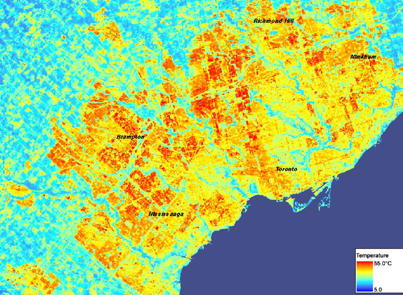
Take, for example, the urban heat island effect. Described by scientists, it concerns the process by which urban surfaces absorb more solar energy and re-admit it as thermal energy (primarily at night) than do surrounding non-paved areas. Better modelling of local and regional climatological processes using citizen sensors can allow cities to pin-point which neighbourhoods are most susceptible to this problem and plan strategically.
Technology may also one day revolutionize how environmental issues are managed locally. The release of open data on neighbourhood energy consumption, water use, and waste disposal make it possible for cities to work with the private sector, non-profits, and academics to better manage flows of materials, goods, and energy in urban areas. Researchers sometimes call such measurement work “urban metabolism.”
“All of those things are being enabled in a way that we’ve never seen before by new technology,” Aylett said. “So the output is becoming a much deeper understanding of how our cities function and the impacts that they have. And where, if you want to think about it like acupuncture, where you can take strategic action in one space that will cause sort of systemic shifts in those impacts.”
He added that visualization and cartographic technologies now make it possible to take information that’s quite complex and make it understandable even for non-experts. What’s more difficult to assess is how such technological tools make possible collaborative action that builds around specific issues as they spread through a community.
Cities in International Climate Politics
Individual cities around the world have shown international and national climate change negotiators what’s possible in tackling climate change mitigation and adaptation, according to Aylett. This despite the inability of some provincial/state and federal governments to incorporate and engage with such local solutions, he added.
Yet much work remains. In an inventory of the open data portals of 20 of the largest Canadian cities Aylett completed last summer, he determined that things like parks and green spaces are well represented while others such as energy consumption or air quality are entirely absent. Aylett hopes the addition of such data will increasingly play an important role in urban environmental management. But it’s still “early days” for this type of open data, he repeated often during the interview, noting that researchers in public health could make a similar complaint.
“So far cities in Canada are not providing on their open data web sites the basic ingredients for innovation around urban sustainability or for you know effective action within the municipality,” he cautioned. “There is a lot of good data that cities have that so far hasn’t been made available. And what that means—it’s a negative and it’s a positive. It means that there is huge potential for the cities that decide to be strategic about it to lay the groundwork for a really interesting period in municipal policy making, and innovation, and experimentation here in Canada.”
Stay tuned for our audio podcast with Alex Aylett to hear him talk about cities and international solutions to climate change as well as how new technologies shape interactions in neighbourhoods and between neighbours on environmental issues.
Also tweet him at @openalex_ and check him out at Open Alex.
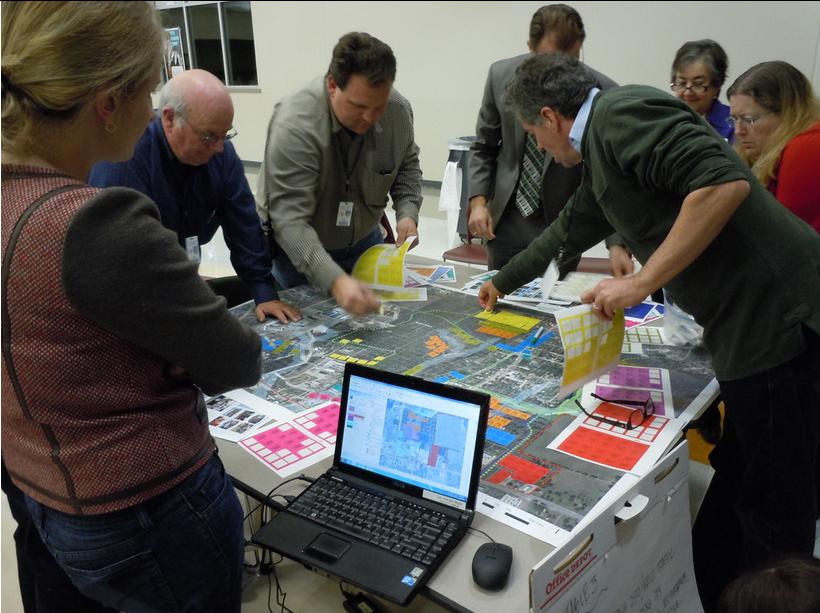
Robert Goodspeed, assistant professor of Urban Planning at the University of Michigan’s Taubman College of Architecture and Urban Planning, examined how decision support systems could be applied to urban planning processes during his doctoral work. This photo is of one such process in Dripping Springs, Texas.
By Drew Bush
The decision support market, a segment of the healthcare industry, made financial headlines when estimation of its global value by 2019 reached USD 239 billion, a jump of almost 38 billion since 2012. According to a new report, major players in the industry have poured money into new technologies that can take advantage of big data.
Digital health initiatives like those led by Canada Health Infoway have led to the creation of a network of systems that securely connect and share health information. Decision Support Systems like this one utilize computer-based data to aid in individual decision-making by supplying a massive bank of previous cases that aid in choosing the most likely answer or predicting trends. Most consist of interactive computer-based systems that utilize data and models to solve problems requiring geographically or temporally dispersed information.
In healthcare, IBM’s Watson system has been leading the trend to improve decisions made by doctors. “Watson knows what tests are relevant to further characterize a particular patient condition and what tests are not,” the report states. “It is a great help to physicians to have an assistant that is able to have read the latest journal articles and is loaded with medical information to recommend what tests may be relevant in a particular situation.”
An estimated 30 percent of all costs incurred for healthcare delivery come from tests that are either of little value in a patient’s case or sometimes outright wrong, according to some reports. Like platforms offered in other industries, the decision support system engineered by IBM offers the promise of more nuanced testing to enable better decisions on which medical tests can be best applied to specific patient conditions.
Robert Goodspeed, assistant professor of Urban Planning at the University of Michigan’s Taubman College of Architecture and Urban Planning, studies decision support systems.
Although Goodspeed doesn’t work in healthcare, his research examines what he refers to as “planning support systems.” His work has looked at how we can use information technology to improve processes that engage community members in urban planning decisions. During his doctoral work, he created a process that allowed individuals to access information about their neighborhood and city to improve discussions.
This research involved community members placing stickers on maps to categorize specific areas for different land uses. This data was then transferred to digital form with one person entering the data as it was called out. Interactions such as this ensured entering the data could be reviewed by the group as a whole and reflected the ideas that they had discussed.
“The participants reported learning quite a bit and I could observe their plans evolving,” Goodspeed said. “So that’s just one example of the sorts of tools and practices that I think or feel we need. Especially as we’re facing issues like climate change where we want to quantify things and create indicators, and know how the plans we are creating are going to do or how they’ll perform against these different indicators.”
The Varied Uses of Decision/Planning Support Systems
In more recent research, Goodspeed has taken his work with planning support systems and applied it to improve environmental-decision-making processes surrounding North America’s Great Lakes ecosystems. Work he’s done as part of the Great Lakes Aquatic Habitat Framework project have used GIS datasets to examine aquatic habitats such as streams, rivers, and lakes in the region. The process also supplies a “big pile of data” for decision-makers in the fisheries and environmental management departments in Canada and the United States.
Unlike in planning where professional tasks follow a somewhat structured process, ecosystem-based management systems must consider a whole variety of information and tasks, Goodspeed said. Work in the project has included leading participatory design workshops for professionals north and south of the border to aid in the development of a tool that will one day allow easy digital examination off all the information on the Great Lakes collected for the project.
Community participation in planning processes that help to envision the possible future often result in a final product that’s inherently more understandable, Goodspeed added.
“And really it requires that kind of combination of creativity but being specific about what you think will happen and what you think will work,” he said of his work with decision-support systems. As big data is increasingly used to inform decision-making, this trend will only continue to grow beyond the industries of healthcare and environmental planning.
Tweet him @rgoodspeed.
If you have thoughts or questions about this article, get in touch with Drew Bush, Geothink’s digital journalist, at drew.bush@mail.mcgill.ca.