Geothoughts Conversations 4 explores our key research outcomes and influences, and was held near McGill University’s downtown campus in Montreal, Quebec. (Image courtesy of http://jeannesauve.org)
By Sam Lumley
We’re excited to present our 4th episode of Geothoughts Conversations!
This episode recounts a conversation held in June 2018 in the Montreal, QC home of Geothink Head Renee Sieber, a McGill University associate professor in the Department of Geography and School of Environment. It highlighted key research outcomes and influences over Geothink’s journey from beginning to end.
In this episode, we take a look back over five years of fruitful Geothink research. We spoke to Geothink Head Renee Sieber, Co-Applicants Rob Fieck, Daniel Paré and Stéphane Roche, and Geothink students Rachel Bloom and Edgar Baculi about their most memorable experiences with the grant.
Thanks for tuning in. And we hope you subscribe with us at Geothoughts on iTunes. A transcript of this original audio podcast follows.
TRANSCRIPT OF AUDIO PODCAST
Welcome to Geothoughts. I’m Sam Lumley.
[Geothink.ca theme music]
“The Geothink grant that was funded by the social science and humanities research council of Canada is coming to an end. We have done great work in terms of creating new theories, new frameworks, new applications, new data sets new collaborations.”
That was Geothink Head Renee Sieber, an associate professor at McGill University’s Department of Geography and School of Environment. Funded by Canada’s Social Sciences and Humanities Research Council, the Geothink partnership grant has involved 26 researchers and 30 partners, while also training more than 100 students. As the grant wraps up, we’ve been hearing from our researchers and students as they reflect on their involvement in the grant over the past five years.
We started off by speaking to former Geothink student Rachel Bloom about her most memorable experiences with the grant.
“I was the lead of Geothink’s Open Data Standards project when I was a student at McGill University. The most memorable Geothink experience would have to be designing a survey that I delivered to open data publishers at cities in north america about open-data standards. It’s memorable because it was a really challenging process due to my research topic being so new. And it also helped me develop my skills as a researcher for the future.”
The Geothink grant has brought together researchers from many different backgrounds and from different parts of the world. It was this point that Geothink co-applicant Rob Feick, an associate professor in Waterloo University’s School of Planning, emphasised while talking about the influence of Geothink on his own work.
“My research has really benefited from my work with Geothink in a few ways, one of which is Geothink is really a multi disciplinary network. It’s a network of people that span disciplines from geography, law, planning and a host of others. And having these different types of expertise around the table has really helped ground my research.”
“It’s also very applied work we’re working with local regional governments on problems that matter to people, both problems that matter to people right now and those that people are seeing both in the research community and in applied context, coming down the pipe in future years. So one of the ways, just using special data quality as of those areas that a number of us have been looking at and that that I have really benefited from in my exposure in Geothink, is understanding that it is far less of a technical matter and it’s a combination of technical and a social and governance matter, and we’re starting to understand that something that we thought was relatively simple, of spatial data quality, is much more complex.”
This interdisciplinary approach was also highlighted by Sieber, as being essential to exploring how interactions between citizens and government are mediated by technology.
“It’s been marvelous in terms of the interdisciplinary of bringing together geographers lawyers, people in the private sector, people in government to work on issues of what’s happening to the conversations between citizens and cities. And on how can we make sure the technology is not an impediment, but actually enhances that conversation”
Working alongside people from different academic fields can help to offer a broader perspective on the big issues facing citizens and governments. It also led some Geothink researchers to shift their own own research interests. This was the case for Geothink Co-Applicant Stéphane Roche, an associate professor in University Laval’s Department of Geomatics, who talked about his focus moving from the technical to the ethical over the course of the grant.
“My main interest within Geothink was more about social inclusion within a smart city context, spatial justice and ethics, which was quite far from what I was supposed to do at the beginning. So in my case, the move was quite big. Geothink is as a network different sectors, different disciplines, different expertise, and working on these issues around the relationship between spatial and social justice, cities and technology. And that that was really remarkable. I really enjoyed and appreciated the the dynamism and the motivation of our group of students, some of them coming from law, some others from engineering some from social science. And it was really rich in term of interaction.”
Throughout the grant new partnerships and opportunities have emerged, and co-applicant Daniel Paré, an associate professor in the University of Ottawa’s Department of Communication and School of Information Studies, highlighted his new collaborations with the Open Government Partnership.
“My involvement with Geothink has influenced my research in so much as it has opened the door towards getting to work with OGP partnership. So based on my Geothink work in open data and open government, that’s transformed, if you will, into the role with the OGP. Where I’m responsible for overseeing assessments of the implementation of Ontario’s Open Data Action Plan.”
We went on to ask Paré about his most memorable experiences as part of the grant.
“I think the most memorable experience has been working with the great team that was put together, and that includes our great team of students that are brought together every year in terms of the student based meetings and such. So for me that’s always been a highlight of the team actually getting together physically and meeting over a period of three to four days. That’s been key; those sessions always been so rich on multiple levels.”
Opportunities for collaboration and exchange were facilitated by the four Geothink summer institutes. Many collaborators and partners emphasised how helpful it was to bring researchers, partners and students together under one roof. Feick pointed to 2015 Summer Institute held at McGill University as being his most memorable moment.
“I’ve had a lot of memorable moments in this in this project over the years, but I think the one that sticks with me the most was at a summer institute that we had for the Geothink students here at waterloo. The summer institutes are opportunities where students from a variety of different universities could come together and work on an applied problem and learn about a particular aspect of geospatial information and its interfacing with society.”
“Students in this particular summer institute had the task of developing an application. We had teams of students that hadn’t met before that came together over the course of a week and put together some really fantastic applications. And these applications, I think, spurred a lot of their own research that they were going to continue on with, but also was really interesting to see how again the different perspectives that the students brought, along with those people that were assisting them through the SI, actually came to fruition.”
The summer institutes also stood out to former Geothink student Edgar Baculi, now a graduate researcher in Ryerson’s Department of Geography.
“We have all these disciplines and I remember benefing greatly from talking to the economics student, sociologist, communication and journalism students on the topic open data and it opened my mind to the idea of, if we’re talking about open data it’s not just going to be the GIS people who are going to benefit or the academics, it’s going to be the sociology students, it’s going to be a journalist from the Toronto Star, it’s going to be all these people who need to understand what open-data is from their perspective and from other perspectives.”
“So, I would say, Geothink was very important in letting me know the inside from other perspectives. And as for networking, that’s a lot of disciplines to go through, and we were all from across canada, and I think actually a few of us were from the States, if I remember correctly, so it was a great networking experience. Many of them are still friends of mine on twitter and LinkedIn, so, great experience.”
The five-year Geothink Partnership Grant may be coming to its conclusion, but the research and its applications will continue. We asked Sieber what lay in store for Geothink’s research themes, the community the partnership helped to foster and the grant’s continuing work.
“We have transformed, I’m happy to say, the lives of over 100 students. I’d like to think that we transformed the lives of many people in the public sector and the private sector across canada. I know it has certainly transformed my life. It has transformed the life of the researchers involved in this project.”
“So while this grant ends, that doesn’t mean that Geothink as a concept, and a research trajectory has ended. Many of our apps will live on beyond us. Certainly our research and our own research trajectories have been changed as a result, so that work’s going to go on even after the grant ends. And, of course, we’re also looking for new grants to pursue this research!”
[Geothink.ca theme music]
[Voice over: Geothoughts are brought to you by Geothink.ca supported by generous funding from Canada’s Social Sciences and Research Council and generous donations from our grant partners.]
###
If you have thoughts or questions about this podcast, get in touch with Sam Lumley, Geothink’s digital journalist, at sam.lumley@mail.mcgill.ca.
In this final issue we celebrate the culmination of five years of successful Geothink
research and present reflections from our faculty and staff.
We also catch up with Geothink Co-Applicant Leslie Shade, former Geothink student Edgar Baculi, and 2017 Geothink Summer Institute attendees Local Logic.
If you have feedback or content for the newsletter, please contact the Editor, Sam Lumley.
A new bridge is currently under construction next to Montreal’s Champlain Bridge. With Local Logic’s innovative approach, future planning decisions about bridges could be informed through detailed analysis of their impact on surrounding roads and neighborhoods.
By Drew Bush
When Local Logic co-founder and CEO Vincent Charles Hodder stopped by Geothink’s 2017 Summer Institute last year at McGill University in Montreal, QC, his presentation was a highlight for many of the students, faculty, and staff in attendance. Hodder’s company applies an innovative approach to improving the policies and practices of governments and their citizens through the use of urban geospatial data and modeling.
“We call ourselves urban planners turned data scientists,” Hodder told Geothink last summer. “So we’re really at the intersection of planning, data, data science, and then technology.”
Hodder told students his company was born out of his master’s work in McGill University’s School of Urban Planning and collaboration with students and faculty. At the time, the Canada Social Sciences and Humanities Research Council (SSHRC) Geothink partnership grant did not exist. But it would have been quite useful during his studies, he noted.
“Having people think about these issues while they’re in school I think is really important,” Hodder said. “And I think there is a lot of space for innovation in terms of cities, in terms of smart cities, and in using technology and having an impact on cities. So much so that we actually started a Meet-Up group in Montreal called Cities and Tech.”
Hodder and his colleagues have done more than start this group. His company has more than 15 full-time staff—including a former Geothink student. In the past few years, Local Logic has also expanded on its initial contributions to improving how urban development takes place or citizens choose their lodging. (His company’s approach allows you to know things like if your next prospective host on Airbnb might be located on a quiet or noisy street.)
Local Logic’s new ventures have moved beyond private real estate to focus on impacting municipal and urban planning and policy. He argues that his company stands at a crossroads. Their task is to redefine how governments create and present physical projects and accompanying policies so that individual citizens will better understand the impacts on their own lives.
“A lot of times these very large investments in public transportation, for example, are hard to understand for the citizen because it’s really difficult to kind of see the concrete impact on your life and on your daily activities,” Hodder said. “So, using our data we’ll be able to bring it down to that level of analysis and really see the difference in terms of, you know, housing values, lifestyle, and access to specific modes of transportation.”
“[Local Logic] mak[es] it much easier for people to understand the type of impact it will have on their lives,” he added. “For them, the citizens, to be able to make better decisions on whether or not to support these initiatives.”
Hodder’s company takes urban geospatial data collected in cities from now ubiquitous sensors and digital technologies such as smartphones. From this data, he and his colleagues work to painstakingly build models of urban spaces. This work starts with each individual street segment. On each street segment, coders must input all types of attributes relevant to a given project. These might include the width of streets, the height of buildings, the tree canopy, or how streets connect to adjoining infrastructure.
The resulting model has held a 94 percent confidence rate when applied to practical situations. It has been used to determine how best to place Bixi Bike locations in Montreal and to help housing developers better understand the needs of their potential customers. Future work may even evolve to include decision-makers in the federal government.
“We thought, what if we applied this way of analyzing the city to these kind of more macro issues as well,” Hodder said. “And then we realized there was this huge opportunity and there’s all this data available.”
Check out a video of Local Logic Co-Founder and CEO Vincent Charles Hodder talking at the 2017 Geothink Summer Institute in the second half of this video also featuring SmartHalo Co-Founder Xavier Peich.
Take a not-so-hypothetical situation as an example. Imagine one day that city officials in Quebec City and surrounding regions are planning a new bridge to cross from the North Shore to the South Shore of the Saint Lawrence River. Wouldn’t it be beneficial for governmental officials and their citizens to know how an automobile bridge versus one meant for bus rapid transit or rail affects traffic in surrounding neighborhoods and roads?
Local Logic’s effort to bring together academic researchers and stakeholders (who use technology to tackle urban problems) reflects an aim shared with the now concluding Geothink partnership research grant. The company’s work mirrors many of the lessons learned by Geothink’s researchers, students, and nonprofit, industry, and municipal partners. This helped to make Hodder’s presentation last summer quite compelling.
“It’s exciting to say,” he said. “But maybe we’ll have a real impact on the ways that cities are actually being built.”
###
If you have thoughts or questions about the article, get in touch with Drew Bush, Geothink’s digital journalist, at drew.bush@mail.mcgill.ca.
In this issue, we celebrate the start of a new year by reflecting upon five successful Geothink&Learn webinars and highlighting exciting new Geothink research.
We catch up with Geothink Co-Applicant Teresa Scassa about her work on data deficits
in the sharing economy; Geothink Collaborator Muki Haklay about his new open course
on Citizen Science; former Geothink student Julia Conzon about her recent appointment
at Employment and Social Development Canada; and other grant news.
If you have feedback or content for the newsletter, please contact the Editor, Sam Lumley.
Geothink and the Center for Government Excellence (GovEx) at Johns Hopkins University launch a first-of-its-kind international Open Data Standards Directory this past November.
By Rachel Bloom
This post originally appeared on Policy Options Politiques. Rachel Bloom is project manager of Open Smart Cities in Canada at OpenNorth, Canada’s leading nonprofit that specializes in open data and civic technologies. She was project lead of Geothink’s Open Data Standards Project.
Canadians who rely on public transit know how uncomfortable it is to wait outside for a bus on the coldest day of winter. Some Canadians are turning to transit apps that display information about bus locations in real time on their phones to avoid the cold.
What people who use those apps might not know is that an array of legal, institutional and technical obstacles had to be overcome before that information ended up on their phones. It journeyed from the public transit agency that collected it to the app developer that repurposed it so it could be displayed on a mobile interface. This seamless way of providing data, in a medium that is automatic and easy to read, has made such apps extremely successful.
How do the data make that journey? Could the technology be replicated to improve access to all kinds of city data? And could the technology be put to use not just for innovative services but also to support more transparent and interactive governance?
Data standards can provide public data in a manner that allows them to be shared automatically across disparate systems and to be open and relatively easy to repurpose. When it comes to public transit information, the most commonly applied standard is the General Transit Feed Specification (GTFS). The standard was collaboratively developed by the City of Portland’s Transit Agency, TriMet, which provided the data, and Google, the developer of the script that exported the data into the open format to be repurposed. The initiative arose partly from a perceived need by a civil servant to make transit directions as easily accessible as driving directions. Thanks to the relative simplicity of the format, hundreds of jurisdictions worldwide have adopted the standard and now provide raw data about transit schedules openly online.
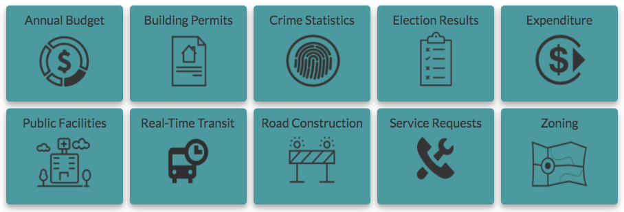
Since the launch of GTFS in 2005, other data specifications intended for adoption by multiple jurisdictions as a standard have emerged for different types of data that deliver government-derived information (such as service requests, budgets and traffic incidents). When multiple municipalities adopt the same sets of standards for their data, suddenly such data are comparable and discoverable. Tools that have been useful in one jurisdiction can then be scaled up for multiple jurisdictions. For instance, Yelp displays food inspection data in multiple cities with the help of LIVES, an open data standard for restaurant inspection data.
To help more cities standardize their open data, Geothink, a Canadian geospatial and open data research partnership, and the Center for Government Excellence, affiliated with Johns Hopkins University, have collaborated to release the first-ever Open Data Standards Directory. The online site intends to help cities publish open data online by providing a systematic approach to assessing standards based on a set of metrics. The directory communicates a wide array of information about each standard, including its background characteristics (name, publisher, publisher reputation, etc.), its ability to make certain types of data interoperable, the degree to which it’s open to use and transparent to others, its maintenance and development over time and how it specifies the standard’s and the data set’s terms of use. This set of metrics will inform judgments that assist providers of open data in their decisions to reject or adopt standards.
Governments at the international, national, regional and civic levels are increasingly opening their high-value data via online catalogues that publish data sets under open licences and machine-readable formats. In Canada, Ontario and the City of Edmonton have adopted the International Open Data Charter. The charter provides an aspirational set of principles for releasing open data, including the idea that they be comparable and interoperable. This goal aids not only the publication of open data but also the coordination necessary to provide the data in ways that are useful. Yet making data truly open is no easy task. There are different approaches to tackling interoperability. Furthermore, an array of complex coordination and technical challenges come with standardizing data to ensure that data will be interoperable.
News about Alphabet Inc.’s Sidewalk Lab in Toronto has brought to the forefront a debate over what role the private sector should play as local governments promote embedding technologies (such as sensors and cameras) that collect and act on data into public spaces. While proponents of the project are voicing their excitement about the urban project and its technological solutions, some are more critical of it and are drafting a list of crucial questions for project administrators and the city related to project governance, data access and data governance, public engagement, inclusivity, privacy law and the technology’s hard infrastructure. As both private and public organizations work to become more digitally connected and more data driven, it is critical to pause and reflect on who develops and maintains these technologies and to consider their purpose and proposed value.
Technologies that act on and automate public data provided by the government and used to govern should be developed in consultation with many types of stakeholders. The release of the Open Data Standards Directory (which I helped to create) makes this approach a reality. The aim is to educate people more broadly about what data standards are and how they can help data remain accessible to cities and their citizens. Otherwise, you may find yourself left out and waiting for your bus in the cold.
Inside this fall’s edition we celebrate the transition to the ultimate year of the Geothink partnership research grant.
We also bring updates on recent Geothink research, including the announcement of Geothink Student Shelley Cook as the awardee of the Dr. Alexander Aylett Scholarship in Urban Sustainability and Innovation.
If you have feedback or content for the newsletter, please contact the Editor, Sam Lumley.
Geothink and the Center for Government Excellence (GovEx) at Johns Hopkins University launched a first-of-its-kind Open Data Standards Directory today that identifies and assembles standards for open data shared by governments.
By Sam Lumley
Geothink and the Center for Government Excellence (GovEx) at Johns Hopkins University launched a first-of-its-kind Open Data Standards Directory today that identifies and assembles standards for open data shared by governments. The new directory provides guidance on the best format for sharing specific types of data to ensure its interoperability across local, regional and national jurisdictions.
The site began as a Geothink project led by McGill University student Rachel Bloom and was supervised by Geothink Head Renee Sieber, an associate professor in McGill University’s Department of Geography and School of Environment. For her undergraduate honors research in the Department of Geography, Bloom developed a tool for searching and querying relevant open data standard for a diverse range of municipal open data. In partnership with GovEx, Julia Conzon and Nicolas Levy as McGill undergraduate students contributed to the project via visualizing and researching the directory.
Former McGill University student Rachel Bloom initiated the Open Data Standards Directory as her undergraduate honors project.
“I think one of the biggest challenges was providing this information in a way that was easily accessible in a dashboard format,” Bloom said. “It was difficult because the standards are complex and it’s hard to capture all of the desired information about them in an easy visual style based around our users.”
“The standards directory helps people not only know what’s out there,” she added. “But based on a systematic approach, it allows people to also evaluate the standard and help them on their decision of which one to adopt. So I think that’s really valuable.”
This initiative has been further developed by The Center for Government Excellence (GovEx) at Johns Hopkins University in partnership with Geothink and members of the open data community. It now represents the first ever international data standards directory. It helps governments provide data in formats that will most effectively support informed decision-making and the provision of services.
“There’s a serious need for coordination on how governments at all levels classify different types of open data,” Sieber said. “A collaboration with McGill University, this directory provides a comprehensive inventory of how data on transit, road construction, public facilities and more has been classified. It also allows evaluation of different standards to help guide governments in choosing the most useful ones.”
The project emphasizes a collaborative approach that opens a two-way dialogue with municipalities. This allows its creators to better understand what is valued within the decision-making process and to encourage the adoption of specific standards for how open data is released. Users around the world are able and encouraged to contribute additional information and update existing standards.
“Open data improves the lives of hundreds of millions of people, many incrementally and some dramatically,” Andrew Nicklin, GovEx Director of Data Practices, said. “Our new directory will encourage global standards for how data is organized for more effective production and consumption at scale. This will insure an even greater impact on the local government services level.”
Historically, city governments and others have faced several challenges in dealing with open data sets. Among these challenges is a lack of agreement and coordination on how data sets should be structured to best serve the public that are intended to be able to access them. The establishment and organisation of common standards can address this problem by encouraging practices that ensure data is accessible and usable by citizens. It can also ensure that datasets released by differing municipalities will be interoperable.
“The directory’s inventory helps simplify and demystify choices for governments and citizens by answering the question ‘what’s out there?’ but also takes it a step further by assessing the value of these standards to a city’s data provision,” said Jean-Noé Landry, Executive Director of OpenNorth, a Geothink partner in this work. “The directory allows us to align data practices, join up data, and enable emergent data uses. Data interoperability is one key to unlocking open data’s innovation potential and we believe this inventory is a very important step towards it.”
Currently there are over 60 standards on the directory from around the world and in multiple languages. GovEx hope to expand these efforts to continually broaden its range of standards, languages and user-bases.
To find out more about the open data standards directory project, you can listen to Geothink’s podcast on the initial project, catch an update on GovEx’s latest Datapoints podcast or visit the GovEx Beta Data Standards Directory website.
###
If you have thoughts or questions about the article, get in touch with Sam Lumley, Geothink’s newsletter editor, at sam.lumley@mail.mcgill.ca.