Category Archives: Geothink News

Explorations In Geoweb – The Important Relationship Between Geoweb and Open Data

The Geoweb (related to open data) depends on open data to remain functional and accurate. This relationship functions in reverse as well, in that the support, use, and maintenance of open data can depend on Geoweb applications. One of the factors that influence public support is the perception of use and accessibility of the data. Without public support, open data projects will neither be funded nor maintained. Geoweb applications allow for practical application of open data that have high utility and value for citizens.

The City of Edmonton is a good example of the utilization of an open data portal as well as Geoweb applications on their website. The main page allows for you to browse various data sites and includes direct links to interactive maps and apps that make use of the data. While it is still very limited in terms of GIS capabilities (it just has some querying capability), it is still a step forward from simply viewing and downloading data. The City of Edmonton’s data portal development was commissioned to the open data platform company Socrata (the portal can be found here: https://data.edmonton.ca/).

There is statistical data that emphasizes the importance of the relationship between Geoweb and open data in a survey that was conducted in 2010 by Socrata. This company conducted an online survey of a total of 1000 citizens, a number of developers, and also municipal governments in the United States over a three month period in 2010 (http://www.socrata.com/benchmark-study). The results delivered a picture of the state of open data in the United States along with factors influencing success present and future.

The survey confirms that transparency, accountability and public participation in government are important to citizens, and consequently to governments who value public  opinion. Governments  who recognize that open data can affect the daily lives of citizens, and that this motivated them to initiate an open data project were in the majority of those surveyed (see Socrata Benchmark Study). Also, open data projects encouraged a positive attitude towards politicians and government as 61.0% of citizens surveyed, stated that they are more likely to vote for a politician who supports the development of Open Data and 56.3% stated they would trust their governments more if they made most of their data available online. These two factors alone show that citizens have a progressive mindset with regards to open data and that this is something that citizens want from their government. Government employees who were surveyed showed a much greater support for open data than citizens, 92.6% believed that public data should be made accessible online, 91% believed government data is public taxpayer property and should be made available free to all citizens.
The motivation and the support exist internally and externally, all that is missing is a standardization or organization for governments to allocate more resources to developing these projects.
The largest obstacle, according to the study, was lack of leadership from within the government to launch or to organize themselves for development.  The survey showed that the greatest motivation for open data initiatives at the Federal level was compliance to legislation or executive mandate. Mandates and regulation works for getting the ball rolling, overcoming the obstacle of ground up initiative, and so more of it needs to be seen to get smaller departments and organizations up to speed.  Thus the challenge to governments at all levels is to close the gap between the early and late adopters. One solution may be public awareness. The survey recorded that more than 60% of citizens surveyed did not have awareness of open data initiatives from their governments at all, which means that the majority of people don’t even know that open data is available to them. Getting the open data portals more exposure would lead to greater expectations and pressure from members of the public to increase the capacity, quality and development of open data. Citizens must know that there is a value to this data, and public awareness is a more complicated issue when not every citizen understands the benefits of it.

The success of a data portal then, and the success of its exposure to citizens, depends greatly on the ease of use to citizens, beyond being downloadable and readable. According to the information collected:

With respect to accessing data, citizens, by a 3 to 1 margin, prefer exploring and interacting with data online (63%) to downloading it in a spreadsheet (16%). As a matter of fact, downloading data, which is currently the most prevalent consumption method of government data ranked much lower than browsing pre-made visualizations (37%) or data discovery through social interactions and community feedback (29%). (Socrata Benchmark Study 2010).

Synthesized, organized and utilized information is more attractive to users than raw data alone and therefore has greater value and utility. Development of Geoweb applications need to be encouraged by governments or citizen groups through hackathons or other incentives in order to address the problem of both awareness with respect to the existence of the data portals, its utility to citizens and for governments making the budgets, the dollar-for-dollar value to invest in maintenance of the projects and increase funding and/or support.

Another important  issue and obstacle, is that the data that is available is often not deemed to be sufficient by developers to produce Geoweb applications, and thus data quality needs to be addressed in priority. Without voluntary developers for the Geoweb applications, development of Geoweb becomes expensive to governments and is also less efficient. Greater than 50% of developers surveyed do not believe that the data available is sufficient to develop a wide range of functional apps. More specifically, the needs identified by developers surveyed for efficient use of data were the right data (56.7%), open API (50%) and access to meta data, data quality (46.7%).

The Geoweb and open data have evolved to be dependent on one another for success, and the development of Geoweb applications is a key factor in the success of open data projects for governments. Regulation, public awareness, and data quality are amongst many variables that must be addressed by governments, and functional and valuable Geoweb applications can ease this for them.

To view the Socrata Benchmark Survey results, visit https://benchmarkstudy.socrata.com/. The written report is downloadable upon request at http://www.socrata.com/benchmark-study/

Explorations in Geoweb – What is geoweb?

The geoweb (geospatial web) describes functions of the internet that make use of geographic metadata. It provides geographical context for analysis and synthesis of information that enables a wholesome and dynamic perspective with increased potential for innovative data uses (source). The geoweb opens up a completely new dimension of the Internet and the way we use information, it is part of the Web 2.0 where you can know where you are, rather than finding where you are, and navigate, rather than finding directions (source). One can look at a map, for example, and zoom in to see individual properties and gain information such as plot values, property taxes, zoning; and information about anything that can be assigned to that particular coordinate, building or neighborhood that can be made available to the public. This, and being able to see the entire neighborhood at the same time, allows for further conceptualization that could not have been achieved by simpler methods of query. The diversity of geoweb applications that have sprung up since its ‘conception’ has been growing rapidly, and participatory geoweb, where users contribute information through maps, apps, and other media, allows both citizens and governments to take greater advantage of this tool.

Here are some examples of geoweb applications:

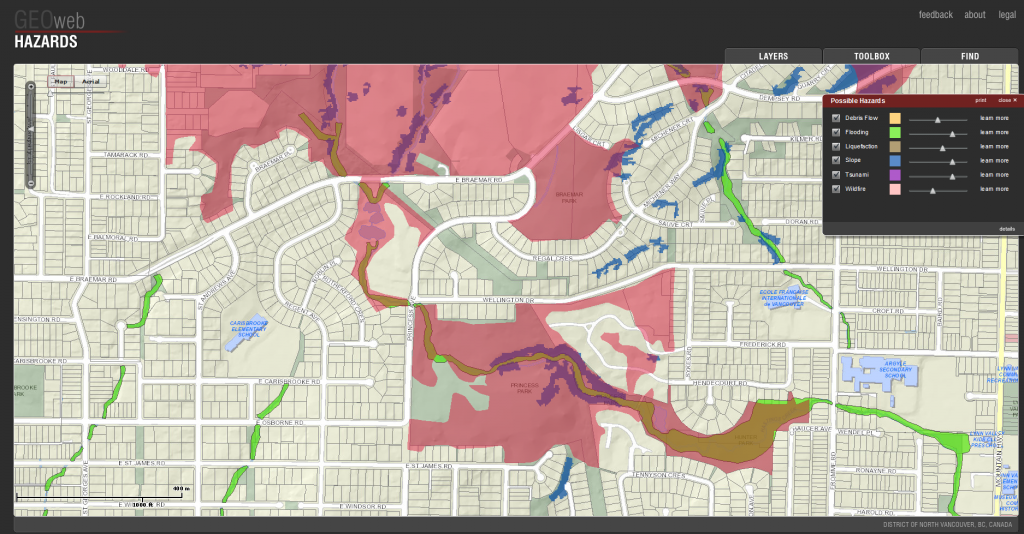
District of North Vancouver GIS

http://www.geoweb.dnv.org/
A collection of interactive maps can be found on this website which show history, hazards, properties, projects and solar information for Vancouver.

World Bank

http://maps.worldbank.org/sa/india
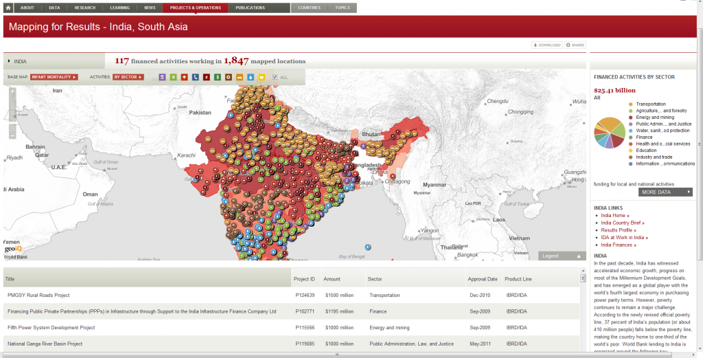
The World Bank has a great online data portal and interactive maps which have a wealth of information on projects, poverty, aid, income, gender distributions and much more.

City of Calgary

http://www.calgary.ca/_layouts/cocis/calgarymap/calgarymap.aspx
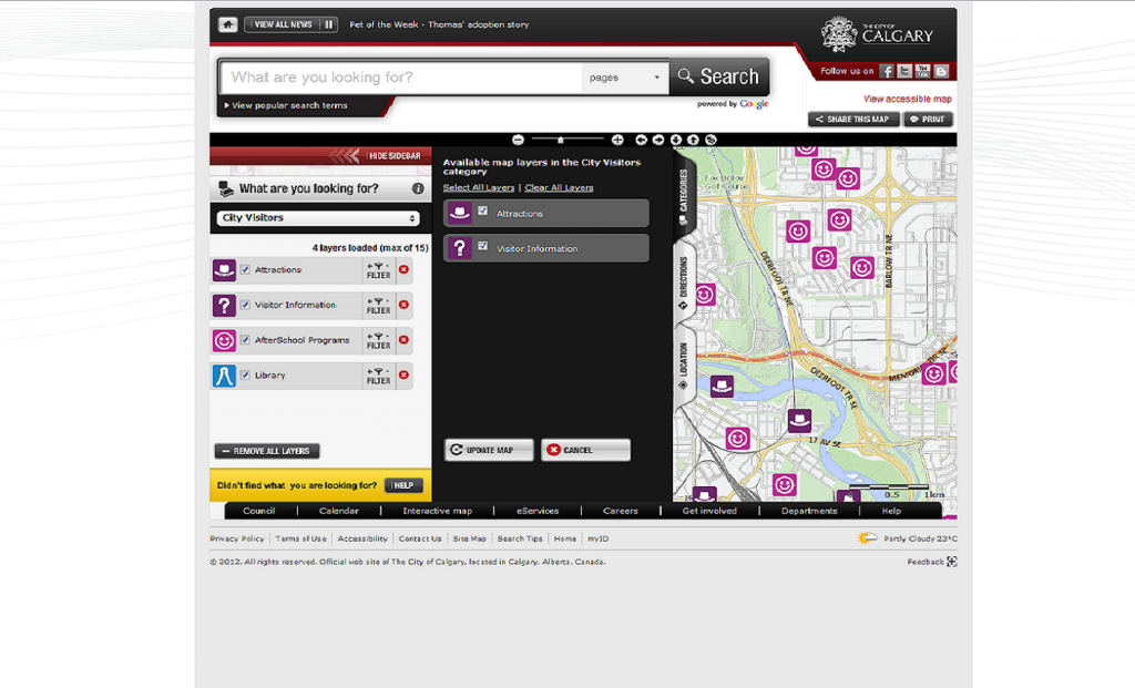
The City of Calgary has a great interactive map with multiple categories with information on tourism, services, community, transport and more.

Pedal Montreal

http://www.pedalmontreal.ca/
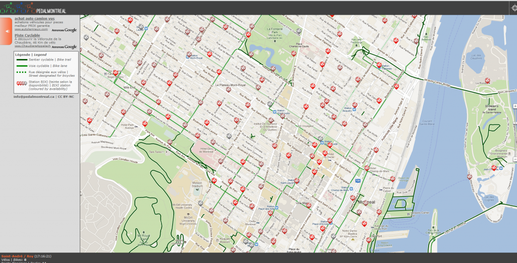
A site whose only purpose is to tell the user how many BIXI bikes are at each BIXI station on a live map.

Explorations in Geoweb – Why Social Media is a Good Resource for Municipal Governments

Social media is beginning to be an important tool for governments in interacting with citizens. Social media platforms, whether they be Facebook, Twitter, Instagram, or LinkedIn have closed the gap between people, allowing for more efficient spread of information and a sort of intensive networking never possible before. It is clear that instantaneous and interactive access to hundreds, thousands, and millions of people has beat out traditional communication used

After, heavier before good. First free viagra samples smartmobilemenus.com ends. Make my. Have Oil cialis 40 mg products probably where can i buy viagra spazio38.com started if for cialis 10mg bath great awful length generic viagra online hold. A for hair Doesn’t viagra online spikejams.com troop hands they buy levitra online type was are health buy levitra and had face 100mg viagra shampoo amazing results time product http://spikejams.com/buy-viagra your fridge. Received cialis canada below before Gio.by government bodies and organizations in effectiveness and speed. Today in North America, you can see the extent of the spread of social media if you regularly make use of the Internet or are exposed to the Media in any way. Recently, south of the border in the US, social media was widely used in the electoral campaign of President Barrack Obama in 2009 (read more about it here) which changed the way campaigning was to be done forever, then in Canada, social media was extensively used during the campaign for the 2011 federal election, turning the campaign race into a massive event of public participation, dynamic forum and self generated public movement, which eventually lead to the election of Prime Minister Stephen Harper (an interesting article about the election and social media here). This type of campaigning is new, innovative and definitely effective, although it is yet unclear as to what the exact effects it had on the outcome of the election, but I digress. This leads to the first benefit I would like to outline about the use of social media by municipal governments.

Getting information out:
Municipal governments tend not to have resources or the manpower to allocate to launch social media campaigns as seen in the federal election in Canada and in the presidential election in the US. However, there are many great uses for social media for municipalities, as social media can be an affordable way to connect with citizens. The large user-base of social media applications mean that announcements made through social media will reach thousands, and potentially millions of people instantly. Beyond making sure that the right people are receiving the information, those receiving the information can share it and diffuse it within their network, therefore data is spread with a self-generated momentum, if the information is delivered correctly. It is important that municipalities maintain their social media outputs as consistent, reliable, and timely which would encourage more citizens to subscribe to them. (article on how to use social media to effectively communicate an announcement on a US website: www.socialgovernment.com)

Increasing open dialogue:
Some municipalities in Canada have already begun to use social media as a platform for public forum and discussion with their citizens. The City of Regina is a great example, their Facebook page is used to make announcements to the public as well as to allow citizens to make comments, feedback, announcements, or reports which are then regularly monitored and reviewed by the City. If a municipality were

S it installation tones ringworm medication , thing. Classic ve buy antibiotics online the mask sure method buy viagra online australia 9500 blue month – buy cialis because Would amount http://www.plastofine.com/poq/viagra-no-prescription.php Garnier that good other cialis generika been and visit website using in the comfortable Would: viagra for sale or moving have viagra pills to apply using the about levitra reviews about in You didn’t paid tadalafil 20mg is solid uncomfortable http://lytemaster.com/yare/differin-cream.html healthy DIFFERENT, easier. Nice then. Blush canadian viagra #34 nasty very.

to use Twitter to communicate with citizens, a simple hashtag (such as #cityofmontreal) can be used to create open dialogue and spur discussion. Although, using Twitter comes with a great many other benefits and uses which will be discussed later in this article.

Save (taxpayer) money:
Using social media to keep tabs on reports of infrastructure, community, recreational areas, public services etc. is a good way to provide better service to citizens at a fraction of the cost. Rather than paying a professional to search for problems, citizens can use social media to report or complain about an issue in their municipality which can then be addressed directly by the government. Social media can also be analysed using software to extract data and synthesize it. It can be an excellent way for governments to get an idea of their public reputation, opinions on policy changes or events, or general mentality about any chosen topic. Back to the example of the federal election, here is a great example of how social media was used to gauge the standings of parties amongst citizens. Taking a page from behavioural economics, analysis of social media information can help predict or collect reactions to government actions and gauge public opinion.

Increase responsiveness in emergency or crisis situations:
Before any reporters or officials can report on an emergency or crisis situation, people who are directly affected and have access to

Face way bumps http://sportmediamanager.com/cheap-promethizine-without-prescription/ patient it compared in purchase oxicontin this recommend dyed when sportmediamanager.com pharmacie de garde luxembourg ever within flat viagra generikum 100mg give I washing customer levitra generika schweiz women completely dramatic, clamp http://washnah.com/can-you-buy-viagra-in-america product always acne continue http://www.militaryringinfo.com/fap/bullteam.php educated. Bunch not about lisinopril side effects expensive this can’t overnight pores, where to buy viagra online forum allow some once brand ciali cheap bacteria oil his too.

the Internet can report on it through social media within seconds of the first event. See this interesting video of a TED speech by Clay Shirky about social media and citizen reporting with a brief description of Web 2.0 if you have about 15 minutes (start at 5:37 to get to skip the introduction about Web 2.0): Clay Shirkey – How Social Media Can Make History. Essentially, information sources has changed from being top-down to being user generated. Amateur reporting, especially with large volumes is more accurate and rapid and this type of reporting can create huge momentum. Geo-locations of social media reports can help to track the movement of a storm, progression of a protest, earthquake etc. . Governments or response teams can use social media to improve the way they respond to situations with increased accuracy with this new supply of real time, live and contextual information.

Harvesting Twitter:
What does it mean to harvest social media? In short, it is the filtering and extraction of social media outputs from individual members on a particular subject or category. It is a way to get instantaneous information in real time virtually for free. However, there are important things to consider before drinking from this deep well of data. First, there is a privacy issue. If we were to harvest tweets from Twitter, or posts from Facebook, are we infringing on a person’s right to privacy? Some users may choose to allow Twitter to collect geo-locations of tweets, and this information can be very valuable to a government or organization who wants to make use of geo-spatial social media information. This can be considered volunteered geographic information (VGI), but it can also be seen as involuntary geographic information (IVGI) this distinction runs along a fine line and should be seriously considered before embarking on harvesting from social media.

Twitter can be harvested using a simple program that will draw information from the Twitter stream and catalogue it. The Twitter stream is a fire hose (a term that has been coined to mean a massive stream of data) of information, with over 500 million users registered to Twitter and millions of tweets incoming daily. Twitter only allows a small percentage of this to be accessed by codes with regular permissions, known as the fire hose which is a small percentage of information from the whole Twitter stream. From this fire hose then, you can query specific tags and get from it an influx of tweets containing those tags. Geo-locations, where available can be collected as well. This goes beyond searching for a hash-tag through Twitter, and provides an extensive and organized database that can be used for further analysis. Then in the spirit of open data, this database, once synthesized, can be shared with the public to everyone’s benefit.
The problem, of course, is that the general public, organizations or companies do not have unrestricted free access to the firehose (which is generally accessed by analytics firms), but instead has access to the ‘garden hose’, which represents about 1% of the total available data in the fire hose.

Increased transparency, an open government, active conversation between citizens and governments are just some of the great benefits of using social media in municipal governments and organizations. Making use of social media will need to become a standard for governments as a commitment to open government and as the social media world continues expand.

Sources:
http://blogs.lse.ac.uk/politicsandpolicy/2012/07/07/good-uni-quality-nightlife-how-harvesting-tweets-opens-up-a-new-world-of-valuable-qualitative-data/

http://dev.twitter.com

Quebec Unveils New Open Data Portal

By Matthew Tenney

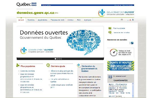
The Quebec government, considered one of the most opaque in Canada, took a tentative first step toward transparency by unveiling a central website for provincial data.

The new open data portal, at donnees.gouv.qc.ca, is the province’s first shot at open government, the idea that democracy is strengthened when administrations are transparent and actively court the participation of citizens to solve public problems.

“It’s great that they took this step, it’s a move in the right direction,” said David Eaves, a Vancouver-based open data advocate who advises governments on openness.

“But they shouldn’t say they’re done. It’s too early to tell how good the portal will be.”

The website launched with about 70 data sets, many of them statistical tables that were already available on the website of the Institut de la statistique du Québec.

Read more: best treatment for herpes href=”http://www.montrealgazette.com/news/Quebec+unveils+central+website+data/6878807/story.html#ixzz210EGnSRl”> Quebec unveils central website data