Category Archives: Geothink News

Geothink Newsletter Issue 5

This Geothink newsletter brings an update for the end of the 2014 year. Inside you’ll find an interview with our partner in the City of Kitchener, highlights from our research team at the University of British Columbia Okanagan, information about two of our Rapid Response Think Tank projects on Open Data Implementation and Geospatial Metadata Standards, and more!

We are working on increasing our media presence, so you can look forward to more media content that will highlight Geothink research. Finally, Geothink students will be hosting more online discussions, such as webinars and Twitter chats. We hope to make these discussion accessible (in terms of content) to everyone in the grant, regardless of your field. Discussions are not restricted to students, so if you are a partner or collaborator and have a topic you wish to host a discussion on, just contact us to set it up.

If you wish to contribute, do not hesitate to get in touch with Peck Sangaimbut.

Geothink Newsletter Issue 5

Canada Action Plan on Open Government 2.0: Much Still To Do?

open_canada_feature_360x203-eng_0

Canada recently completed their public consultation on Open Government (Photo source).

By Drew Bush

Introduction

For the savvy traveller headed over Canada’s border this holiday season, Canada’s Action Plan on Open Government 2.0 holds promise. A visit to the site in December 2014 yielded a multi-media list of steps to follow when travelling abroad and even an iOS “Travel Smart” application.

Drafted after a June 2013 G8 Summit, Canada’s plan results from agreements it made when it signed on to the summit’s Open Data Charter that lays the foundation for usage of open data to promote best government practice.

As a result, Canadians can now get online help with more than just travel. Ever wanted to know how much tax money you spend on government contracts? Or need information on the fuel consumption of a car you might buy?

The goal of the 65 nations committed to these plans is to increase government transparency and accountability, encourage citizen engagement, and stimulate innovation and economic opportunities.

History

Making this type of data more freely available fits with a long tradition in Canada. When the country began participating in the Open Government Partnership (OGP) in September 2011, it committed to making open data (or machine readable, freely used, re-used and redistributed data) open to anyone able to attribute and share it.

Applications of Web 2.0 technologies and social media allow for these types of interactions online with information, datasets and records. In fact, many modern computer programs incorporate Application Programming Interfaces (or APIs) to gain access to datasets for users.

The Open Data Charter recognizes the central role open data plays in improving governance and stimulating innovation in data-driven products and services. It endorses the principle of open by default, an idea also supported by U.S. President Barack Obama’s 2013 Executive Order on open data.

The drafting of the Charter and Obama’s order have elicited praise but also criticism. As Rufus Pollock, Founder of the Open Knowledge Foundation, wrote on his foundation’s blog, “there is still much for the G8, and other countries, to do.” In particular, the early results from an Open Data Census in July 2013 show that G8 countries have a long way to go in opening up essential data.

User Generated Input

Making data and information more available to Canadians isn’t the only goal of the plan. Open government is increasingly becoming a positive force for unity and international cooperation, according to Canada’s President of the Treasury Board, Tony Clement, in his statement “About Open Government”. He claims that open data makes government “more open, accessible, and responsive” by harnessing the “collective ingenuity, drive, and imagination of its people.”

In Canada, this means finding a way for citizens to engage in a two-way dialogue and even contribute datasets. In 2014, the Canadian Open Data Experience appathon again brought together government, industry, academia, and the public to mash up, reuse and remix federal government data. Events like these and communities the plan encourages around interest areas like maps, labour and law help encourage the development of useful, effective applications that use government data.

Short History of Open Government in Canada

  • The Open Government Partnership formally launched on September 20, 2011 when eight founding governments (Brazil, Indonesia, Mexico, Norway, the Philippines, South Africa, the United Kingdom and the United States) endorsed the Open Government Declaration, and announced their country action plans. Canada joined the partnership later that year.
  • On March 18, 2011, the Government of Canada announced its commitment to an open government initiative that focuses on three areas: 1. Making information such as records and activity more easily accessible; 2. Making raw data available in machine-readable formats to citizens, governments, and non-profit/private sector organizations; 3) Giving citizens an opportunity for dialogue on federal policies.
  • In 2011 the Government of Canada launched an Open Data Portal – data.gc.ca – which now has more than 272,000 datasets from 20 departments and which has already resulted in over 100,000 dataset downloads since its launch.
  • All government departments began publishing summaries of completed Access to Information (ATI) requests 2012 monthly on their Web sites.
  • In 2012, the Government of Canada issued its enhanced Values and Ethics Code of conduct for all public officials.
  • A 2013 Government of Canada Social Sciences and Humanities Research Council (SSHRC) partnership grant asks ‘How the Geospatial Web 2.0 is Reshaping Government-Citizen Interactions.’ GeoThink now includes 13 team members and 36 collaborators and partners.

If you have thoughts or questions about the article, get in touch with Drew Bush, Geothink’s digital journalist, at drew.bush@mail.mcgill.ca.

Geothink Newsletter Issue 4

We are happy to announce the publication Geothink’s 4th newsletter, in a new and improved layout.

Inside, you will find updates from the AGM, interviews with the City of Toronto, The Neptis Foundation, and the Canadian Internet Policy and Public Interest Clinic, a list of new Geothink publications, and introductions to three Geothink students.

If you wish to contribute, do not hesitate to get in touch with Peck Sangiambut – the magician behind the newsletter.

Download Geothink Newsletter Issue 4

Re-identification Risk and Proactive Disclosure of Data for Open Government: Lessons from the Supreme Court of Canada?

By Teresa Scassa

One of the challenges with the proactive disclosure of government data, and with open data more generally, is the obligation that governments have to not disclose personal information. This challenge is made more acute by the fact that the definition of “personal information” is, generally speaking, “information about an identifiable individual”.

Courts in Canada have said that identifiability is not considered solely in the context of the particular data set in question – information is personal information if it can lead to the identification of an individual when it is matched with information from virtually any other source.

The Supreme Court of Canada has just released a decision dealing with the issue of whether Ontario’s Ministry of Community Safety and Correctional Services was right to refuse to disclose information relating to the province’s sex offender registry. The concern in this case was that although the applicant sought only data about sex offenders living within the forward sortation areas, indicated by the first 3 letters of a postal code, this information could still be matched with other available information to specifically identify and locate individuals. Although the case deals with the province’s access to information regime, lessons can be extracted that are relevant to both the proactive disclosure of government information and to open data.

For more detail, see my blog post about this case, here: http://www.teresascassa.ca/index.php?option=com_k2&view=item&id=159:re-identification-risk-and-proactive-disclosure-of-data-for-open-government-lessons-from-the-supreme-court-of-canada?&Itemid=80

Teresa Scassa University of Ottawa, Faculty of Law

Hopping the Geofence: A Quick Look at Geofencing Practices

By Matthew Tenney

As we walk, drive, or skip down the road most of us are actively sharing bits of information about ourselves to anyone who cares to listen. The piece(s) of mobile technology we carry with us, nearly ever place we go, is being bombarded by a field of sensors that hear where and who we are.  Often these sensors can talk back to us through emails, SMS, or many other mediums directly to our smartly connected pockets. What they are looking for and what they do with this information is, however, a complex system of applications that vary depending on the kinds of hardware being used to what purpose someone has for listening in the first place.

Strategies known as geofencing utilizes location based services (LBS) within certain geographic zones and are delineated by sensor networks across real-world geographic areas. These invisible fences act as both partitions and catchment areas, which quiet heavily used in today’s digital world whether you are aware of it or not.

One example of geofencing is for commercial enterprises like consumer centers and dissemination of marketing materials. A shopping center can create a radius of interest (or guesstimated trade area) around their locations and “watch” all of those that enter and exit via different LBS. Sometimes these fences will alert you with an ad about their big fire-sale on paperback books, or, maybe extend an exclusive deal to you for: being in the right place, at the right time.

Another popular use of geofences is for safety and security purposes. Acting in this case, more like their traditional counterpart, as a barrier between different places or people. Digital Childcare services can offer a means to track the real-time whereabouts of children and provide different levels of safeguard measures to send alerts when these borders are crossed. Some high-security facilities can take advantage of geofences both inside and outside of buildings. When sensitive materials are at risk geofences can act as an invisible alarm systems that protects both digital and physical materials from leaving authorized areas.

Civic and community organizations have also been using geofences. School and college campuses offer geofences for secure network access to things like student records and other services. Sporting events can send real-time alerts to fans out in the parking lot about the game. Neighborhoods provide community wide Wi-Fi to residents or visitors and share community events. Residents can also use these geofenced zones as if they were mirroring physically gated-neighborhoods and extend heartfelt welcomes – or stern warnings – to those that enter its perimeter.  The state of Texas in the U.S. also sends out SMS alerts to automobile drivers on the interstate system about accidents, missing persons, or other public-service and emergency announcements.

For social networking, geofences can provide an intranet of connections between people that occupy the same geographic location. Providing a means to share messages to peers and outsiders about events and activities, geofencing, can allow people to form co-located digital cliques based on similarities of interest and location. |=|A|+|B|-|A∩B|
Figure 1: Inclusion-exclusion principle of mathematics. For illustrative purposes only. After all, everyone loves a good equation now and again.

While geofencing carries with it plenty of straightforward advantages, it is by definition a procedure of separating people, places, and things through processes of inclusion and exclusion. These processes, be they engineered or naturally formed, define more than just geographic regions, but also claim people, services, and resources via the quick and ready use of widespread modern technologies.

| A∪B|=|A|+|B|-|A∩B|
Figure 1: Inclusion-exclusion principle of mathematics. For illustrative purposes only. After all, everyone loves a good equation now and again.

Social exclusion refers to processes in which individuals or groups of people are blocked from rights, opportunities and resources (e.g. housing, employment, healthcare, civic engagement, democratic participation and due process) that are normally available to members of society and which are key to social integration. Where social inclusion is the opposite processes of offering these things to people and places that they belong.

There is apparent risk of geofencing to be an updated version of redlining, a process of discrimination that isolated certain people by socio-demographic traits like race and class, that dynamically dictate membership of “now you’re in, now you’re not” instantaneously.

A geofencing community can lay claim to another geographic area or alter its boarders as needed to grab a few people here and cut a few over there out. This can both create territorial bounds for community and individual identities and destroy the reputation of others. Social elitists can demarcate the newest hip-scene to be seen in and can at the same time kick to the curb outdated venues or areas as yesterdays hangout spots.

The implications of this rapid construction and destruction of identities has yet to be fully understood, but one can wonder what will the Brooklyn of tomorrow look like? Or, better yet: where will it be tomorrow and who is “in” now and “out” like yesterday?

In order to understand, promote, and prevent the right-and-wrong outcomes of geofencing requires a deeper understanding of what kinds of information is being shared, who is using it, and for what purposes. While technology shows no sign in abating the amount of digital information that can be shared through LBS, geofencing is an inevitable concern for all of us. Whether on onside of the digital divide or another, geofencing will likely define how we understand concepts of the city and ourselves in the future.


Canada’s Open Government Licence V2.0 Is Released


Written by Teresa Scassa

Read more posts by Teresa @ http://www.teresascassa.ca/

With little fanfare, the Canadian government has released its much awaited, newly revised Open GovernmentLicence. The previous version that had been available on its Open Data site was a beta version on which public comments were invited. The government has also published its Open Government Licence Consultation Report, which summarizes and discusses the comments received during the consultation process.

The revised version of the licence is an improvement over its predecessor. Gone is the claim to database rights which do not exist in Canada. (These rights do exist in the UK, the Open Government Licence of which was a template for the Canadian licence). The new licence also discards the UK term “personal data” and replaces it with “personal information”, and it gives this term the meaning ascribed under the federal Privacy Act. The language used in the licence has been further simplified,making it even more accessible.

It should be noted that Alberta’s new open government licence – released as part of the launch of its open government portal earlier this year – is very similar to V2.0 of the federal government licence. There are some minor formatting differences, and a few changes in wording, most of which can be explained by the different jurisdiction (for example, the definition of “personal information” refers to Alberta’s Freedom of Information and Protection of Privacy Act). The similarities between the two licences are no coincidence. Although the Alberta licence was made public prior to the release of the federal government’s V2.0, work has been going on behind the scenes to move towards some form of federal/provincial consensus on the wording of open government licences with a view to ensuring that there is legal interoperability between data sets released by different governments in Canada. The efforts to reduce barriers to interoperability (whether legal or technical) are important to the ability of Canadians to work with and to integrate different data sets in new and innovative ways. Thus not only is the COGL V2.0 to be welcomed, so are the signs that cooperation and coordination may lead to a greater legal interoperability of open government licences across Canada.


Get to know Geothink

By Matthew Tenney

We live in a hyperlocal world, using geospatial technologies in which we contribute, share, and visualize information about our location and activities. Using technologies like Google Maps and GPS-enabled cellphones, individuals tweet about potholes; their mobile apps deliver directions to the nearest coffee shop, whose reviews were contributed by individuals. Governments add to the geographic data stream by increasing accessibility of their data, like real time transportation information. The new mobile forms of map making, called the Geospatial Web 2.0, are important to Canada’s and could regain our lost ground as a world leader in map making and geographic technologies and lead government practices into the future. The emergence of these tools and services provides new capabilities for both non-experts and governments to collectively contribute–to crowdsource–geographic information to a host of social, economic and environmental challenges. The widespread accessibility of these capabilities is significant because it blurs distinctions between user and producer of geographic information and allows citizens to volunteer geographic information with their locations and experiences.

Geothink is a 5-year partnership research grant funded by SSHRC and is one of only 20 grants awarded this year. The initiative is composed of 26 researchers and 30 partners, that range from city officials, business leaders, and academics across Canada. Our primary focus is on the implications of increasing two-way exchanges of geographic information between citizens and governments and the way in which technology shapes, and is shaped by, this exchange.

The primary goal of Geothink is captured in five broad objectives as
follows:

1) Identify best practices development and usage of Geoweb in government

2) Explicate paths for local governments to leverage the Geoweb to
communicate directly with concerned parties.

3) Investigate the social, economic and legal forces shaping means of
governance.

4) Establish a sustainable partner network of regular communication in
which ideas are bottom up and dynamically refined.

5) Train the next generation of leaders who will be highly technically
competent and cognizant of impacts of Geoweb technologies on governance
processes and citizen relationships.

As the grant progresses we will share necessary information for people to better understand and use these technologies for future projects and hopefully lead to significant changes in government practices in light of the research produced by the Geothink team.

We also would like to invite both cities and citizens to participate in any of the activities of Geothink including suggestions on how best to use these new digital technologies and the kind of data that would be most useful to provide.

Stack Exchange Kicks Off New Open Data Forum – Check It Out!!

By Matthew Tenney

“Open Data Stack Exchange is a question and answer site

for developers and researchers interested in open data.

It’s 100% free, no registration required.”


http://opendata.stackexchange.com/


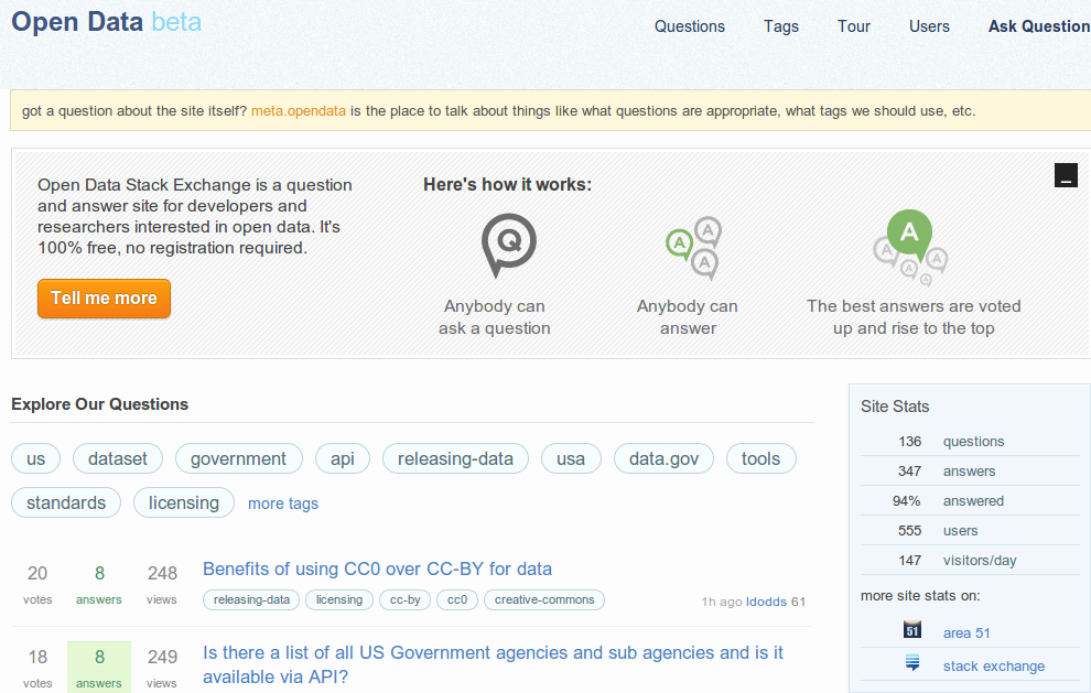
For those of you familiar with Stack Exchange already it is a pleasant sight to find the new Open Data forum online. If you are just now becoming acquainted with the site, welcome to a community of active and knowledgeable individuals where you can further hone your Open Data chops!  Open Data - Stack Exchange Beta is up and running!

Open Data – Stack Exchange Beta is up and running!

While the site is just budding, it has already seen an impressive number of stimulating questions and is carrying a 94% answered rate! Not only will you have leading experts in the fields of computer science and spatial technologies the new Open Data forum welcomes experts in participation, organizational, and data theory.

The range of questions and depth of answers is also driven totally by YOU! So don’t hesitate to post, comment, and answer question with this great resource for those of us interested in Open Data.

http://opendata.stackexchange.com/