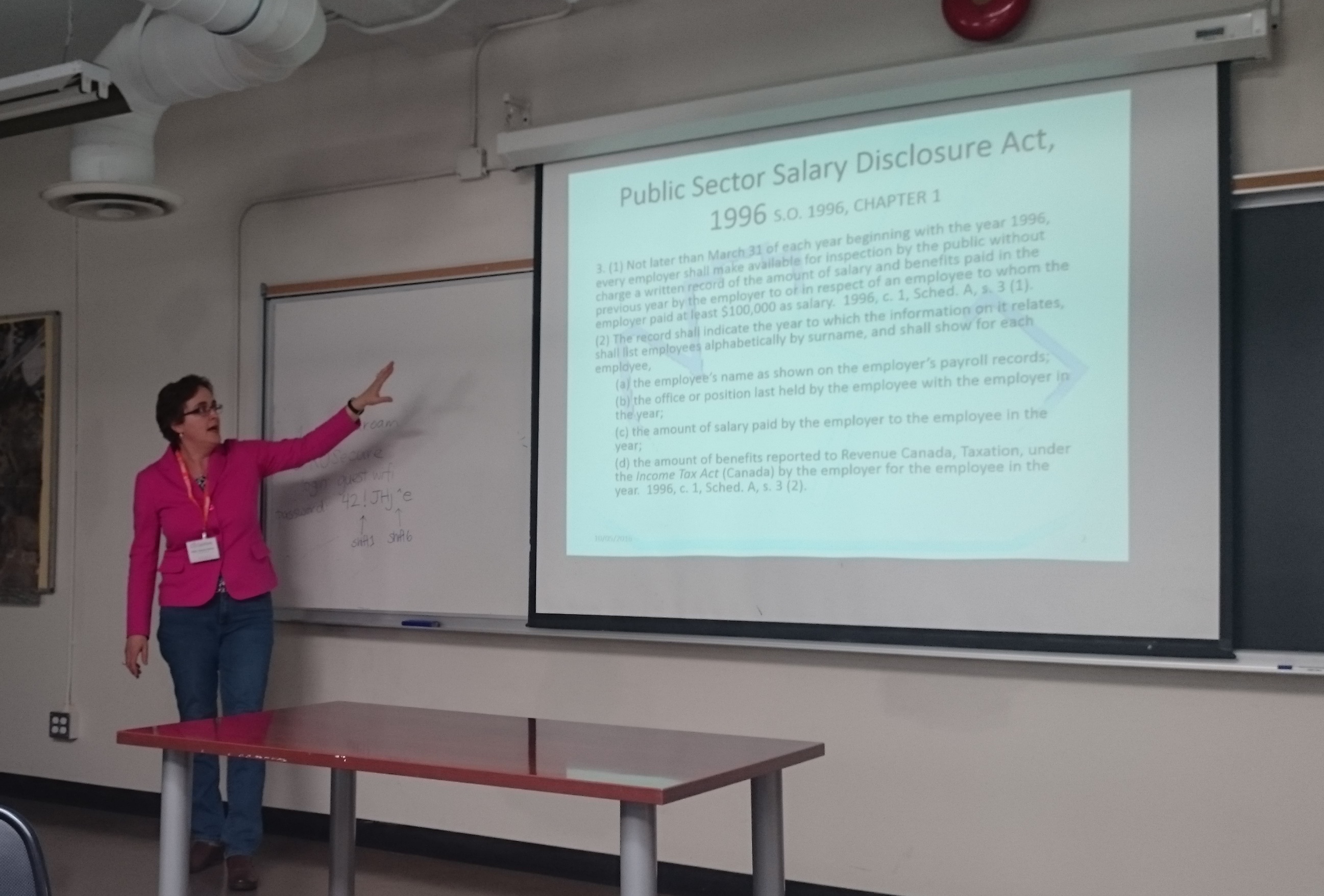
Ryerson University has an exciting new class in The Chang School of Continuining Education. Geothink co-applicant Dr. Pamela Robinson (Ryerson University School of Urban and Regional Planning) has partnered with Civic Tech Toronto to create CVUP 110: Digital Government and Civic Tech. This is a non-credit university course aimed specifically at teaching civil servants about digital-driven change in the public sector. The course covers prototyping, human-centred design, and agile project management.
The course will be held during the Spring/Summer 2017 term, from 8 March to 19 April.
To find out more about the course, you can attend a free information session to be held on 9 February, or see the course description here.
Media coverage in recent months may be focusing on Niantic’s continuous battle with Pokémon GO exploits and the game’s apparent demise, but here at Geothink we still see great potential in augmented reality (AR) games to promote community engagement. Our research examines communities and citizen-government engagement, particularly through geospatial technologies such as the geoweb. At the height of the craze, Pokémon GO resulted in conspicuous movements of people through engagement with a location-based service. This provides us with a convenient case study of the potential effects of a location-based service that causes movement of people through gamification. Geothink has also investigated gamification in urban planning and citizen engagement through platforms such as Minecraft and the precursor to Pokémon GO, Ingress. A recent publication from Geothink student, Lisa Mather Ward, and her supervisor, Dr. Pamela Robinson, has looked at Minecraft’s potential for public consultation.
Pokémon GO and Geography
Geothink co-applicant Dr. Claus Rinner (Ryerson University, Department of Geography and Environmental Studies) has written a post introducing geographic analysis concepts with Pokémon GO. In it, he writes about geographic distribution, catchment areas, and links them to geospatial analysis methods such as buffering, distance decay, and suitability mapping. Some of the built-in distributions of Pokémon (such as having certain types of Pokémon available for certain types of terrain, weather, continents, and time of day) are similar to what we look for in ecological species distribution. The same concepts and techniques are widely used by corporations conducting market research, retail analysis, and location intelligence. As such, Pokémon Go is a great way to introduce basic geographic concepts to students and the interested public.
A Medium for Contestation of Urban Places?
Movements of people that are a direct result of their interaction with a mobile app could result in new contestations of space and place. Pokémon GO is potentially one tool that influences and reassigns cultural identity and platial meaning. In downtown Montreal, we have seen a regular congregation of Pokémon trainers develop around Cabot Square to catch Pokémon, level up, and wrestle for control over its gym. Will this new influx of people change the identity of Cabot Square? Or has this already happened?
Pokémon Go (right) versus swing dancing (left) – is location-based gaming a new tool for contesting space and place? Photo credit: Suthee Sangiambut
Geothink Head, Dr. Renee Sieber (McGill University, Department of Geography and School of Environment), has spoken of the potential abuses or biases that may result from the placement of Pokémon and pokéstops on the map. Algorithms are the determinant for a pokéstop and Pokémon spawn locations. However, as Sieber emphasises, technology itself should never be assumed to be neutral. Implicit biases may be injected by programmers, managers of the technology, and the underlying data. For example, it has been noted that certain neighbourhoods are poorer in pokéstops, potentially due to the distribution biases in crowdsourced contributions that formed a part of the underlying pokéstop dataset.
On the other hand, does location-based gaming have the potential for real-world community building? Are players actually exploring their own communities?
Geothink co-applicant Dr. Stéphane Roche (Université Laval, Département des sciences géomatiques) and his PhD student, Territutea Quesnot have studied landmarks and wayfinding, particularly through social networks with gamified interactions such as FourSquare. As Roche notes, the concept of ‘checking in’ to a location is not new. Pokémon GO’s uniqueness is in its content and in overlaying the Pokémon universe over the real world (such as through the camera feature) with more integration than Ingress. For Roche, such movements of people could also be a form of contestation or appropriation of places. He defines an urban place as “an equation between a physical location, an event, and the name associated with the phenomenon”. Landmarks in the city can therefore have multiple ‘places’ depending on their usage. For example, a pond has one use during the summer, but turns into an ice skating rink during the winter. Pokémon GO, Roche says, “has created new urban places, in a location where existing places were already there”. Roche cautions us to not immediately condemn the phenomenon of Pokémon GO players congregating in large groups, as contestation and appropriation of urban places is not a new process. Pokémon GO itself has not had an entirely negative effect on urban environments and has been attributed as a factor in revitalising the Brussels community after this year’s terrorist attacks.
Roche is optimistic that “gamification and technology has the potential to improve our understanding of the world, improve our skills, including spatial skills, and could help people to discover new components of the world”, but also echoes Sieber’s concerns over algorithmic regulation where, “because of the choices that are embedded in the code and algorithms, there is a kind of orientation and social classification…and it becomes more and more difficult to discover new things”.
For Rinner, government should not have to resort to gamification to promote community engagement or citizen-government interaction, but he admits,
“I am afraid that it will soon be necessary to get anyone to do anything good. So, yes, I expect that government will soon use gamification to motivate people to engage in planning questions or politics. And more concerningly, I expect that businesses will use geolocation games to steer people to the right, or maybe wrong, places.”
AR and Gamification: Potential for Civic Engagement in Urban Planning
Regardless of Pokémon GO’s success, Geothink is looking to investigate the potential of AR in promoting civic engagement at the municipal level. Geothink co-applicant Dr. Pamela Robinson (Ryerson University, School of Urban and Regional Planning) has brought together a group of six masters’ of urban planning graduate students to investigate AR’s potential for the City of Toronto. Their mission is:
To explore the potential of AR technology in relation to public consultation & civic engagement by local governments and to provide a framework for analyzing future engagement opportunities
According to the students, AR has a high potential due to its fusing of the digital and physical. Unlike Virtual Reality (VR), AR does not completely remove the physical world and users can still interact with each other face-to-face, rather than being restricted to a virtual environment.
Currently at a preliminary stage of their project, the students have investigated the distribution of pokéstops and urban accessibility to pokéstops to examine the geographic reach of the game in the city. The density and location of check-in locations for any gamified service are crucial when attempting to attract people to a particular location, such as the location of a public consultation or town hall meeting and also important for evaluating how inclusive the tool can be in terms of reaching residents. The students discovered that a player’s experiences of Pokémon GO can really differ depending on where they live in Toronto.
Team PokéPlan (as they have named themselves) is also looking at other issues that a municipality will be concerned with, such as legal considerations (privacy, liability), language barriers, issues of service coverage and accessibility (the digital divide), and how to reach broad and target audiences, and finally gamification. According to Geothink student Corinna Prior, the City of Toronto has already begun to experiment with more flexible types of consultation such as the Planners in Public Spaces programme where planners go to the people. For Prior, “gamification is a really powerful tool. The potential to get people out and about is really powerful”. If AR and gamification could be used to support public consultation processes, we may experience radical changes in how citizens interact with their municipal governments.
More updates on TeamPokéPlan once their project ramps up. In November, Team PokéPlan will host a World Town Planning Day breakfast (November 8th), be the guest speakers at Civic Tech Toronto’s Hack Night (November 15th) and present their final report on November 22nd. For more information about their work please contact Pamela Robinson.
A new IMFG Perspectives paper posit five steps to foster citizen trust in Canadian municipalities.
By Drew Bush
In a new article, Geothink Co-Applicant Pamela Robinson and her co-author, Dina Graser, posit five steps to foster citizen trust in Canadian municipalities as they attempt to raise funds to cope with almost $400 billion of infrastructure deficit nationwide.
Pamela Robinson is an associate professor at Ryerson University’s School of Urban and Regional Planning.
Published by the Institute on Municipal Finance and Governance (IMFG) at University of Toronto’s Munk School of Global Affairs, A Recipe for Fiscal Trust (No. 13) reviews literature on public trust in government. In September, the authors will host a seminar to elaborate on their work. (Check back here for details when they become available.)
“There’s no shortcuts,” Robinson, an associate professor at Ryerson University’s School of Urban and Regional Planning, said of the paper. “We have to stop thinking about civic engagement and relationship building between local government and members of the general public as discreet events and things that you tick-off, ‘Like, ok, I’ve done that.’ There are—the ways in which relationships are built and maintained and nurtured and cultivated is the active work of government.”
She sees this research as building upon previous Geothink research examining the ways in which civic hackathons reshape citizen-government interactions along with open data. Instead of interrogating how open data makes municipalities more accountable or transparent (or may fail to), this paper examines how it shapes levels of public trust in government. Robinson adds that data itself is not a panacea.
“Data is an input into our process but the data itself won’t give you trust or transparency,” she said. “You have to use the data embedded in broader processes of civic engagement. And so the portal is just the beginning—it’s not the end.”
Robinson warns that the longer municipalities wait to build trust and raise funds, the greater the challenge will be in terms of the huge backlog of municipal infrastructure work that needs to be completed. Particular challenges include governments strapped for resources and money, news cycles with shorter attention spans, and citizen fatigue with governmental processes. Yet, new transit lines or bridges require sustained community engagement.
“Not only is the process of maintaining good citizen-local government relationships really important and hard work,” Robinson said. “It’s going to require more and more attention. And it can’t be just that thing that those people over there do. It needs to be internalized.”
Find the executive summary and citation for the article below:
Citation
Graser, D. & Pamela, R. (2016) A Recipe for Fiscal Trust. IMFG Perspectives, No. 13, p. 1-20.
Executive Summary
Cities across Canada face an enormous infrastructure deficit. From 100-year-old water mains to transit systems in vital need of upgrading and expansion, Canadian infrastructure is widely recognized to be in dire straits. And while the majority of Canadians elected a new government that was prepared to run a deficit to fund infrastructure, these funds alone will not cover the investments needed.
Local governments need to make significant financial investments, too, and must raise revenues through taxes, user fees, and possibly new revenue tools. But before they can take these actions, they have to build trust to convince heir residents that new revenues are needed and will be spent wisely.
What does it mean to build trust? This paper examines the notion of trust and how governments can build it using:
Good information: relevant data made accessible to citizens and attractively packaged to enhance transparency;
Good communications: good stories that are well told, with relevant information distributed through a variety of channels (using open government tools and techniques);
Good engagement: inclusive and meaningful opportunities for dialogue about policy decisions to build the continuum of trust (using a variety of mechanisms);
Credibility: building an effective track record and controlling costs (through better performance benchmarking and other approaches);
Earmarking of funds: creating a dedicated fund that clearly links revenues raised to specific expenditures, and regularly reporting on the progress of projects funded.
This research shows that there are concrete and practical steps that cities can take to build fiscal trust – but there are no shortcuts. Trust-building is a long-term proposition that takes resources. Cities must invest the time and dedicate the resources to build trust through all of the steps outlined, and continue to do so as part of their regular activities.
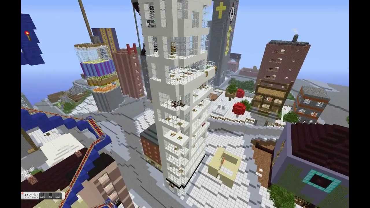
In this episode, we take a look at two Geothink researchers who are investigating how the popular video game Minecraft can be used to improve local and regional planning processes. In particular, we talk with Ryerson University Gold Medal award winner Lisa Ward Mathers, and Ryerson master’s student Jacky Li. Both have worked with Geothink Co-Applicant Pamela Robinson, associate dean in Ryerson University’s School of Urban and Regional Planning.
“We also wanted to build, how do you say, just an open web kind of thing where you can log on and start building away at the city of Toronto. So the vision was to have all of Toronto built in Minecraft and that’s where I came in. I tried to—they hired me to get the program up and going. But I didn’t know how to start. So my research basically consisted of how we would do something like this.”
That’s Ryerson University Master’s Student Jacky Li talking about his work with Minecraft. Li is a student with Geothink Co-Applicant Pamela Robinson, associate dean in Ryerson University’s School of Urban and Regional Planning. Last summer, he interned with the City of Toronto’s Office of the Chief Planner.
Minecraft isn’t so much a game but rather a destination, a technical tool, and a cultural scene all rolled into one program. Children who use it can engineer complex machines; model the world in cube-like form; shoot and post YouTube videos of their work; and setup servers where they can hang out with their friends. The software, initially launched by Mojang (a Swedish game studio) in 2009, now boasts more than 100 million users. Microsoft recently bought it and Mojang for a record $2.5 billion.
“So I looked at examples of, in Sweden, they had really good one with between the architects and the government where they just focused on a suburb and they had users go in and start building. And then last summer, the graduating class of Niagara College [in Welland, Ontario] translated some GIS data into Minecraft. And I contacted them and they taught me how to do it.”
“Yeah so, at the end of it what I made for the city of Toronto was a report that said how to build like the sub-server thing, how to host it, and some potential programming they can do with children such as like a floor area ratio exercise where you can imagine density. So if you’re given solar power, how many blocks can you build different kinds of built forms depending on the criteria of the exercise . Yeah and just stuff like that.”
Li grew up as part of the Minecraft generation. For him, “It’s just a popular computer game where you basically craft things. It’s kind of like Lego, but on your computer, or on your Xbox or PlayStation, or on your mobile phone.”
His work was inspired by another student at Ryerson who wrote a report for the City of Toronto on the educational potential of a tool such as Minecraft that engages students with sometimes complex computer science in an immersive environment. Li is not alone in Geothink as a researcher working to determine how Minecraft can empower communities in urban planning decisions.
“From there I asked them specifically about different contexts within which Minecraft could potentially be used. Different scales, like for instance, a committee of adjustment or, you know, larger scales from there like an official plan review. I’m sort of asking what do you think, would this work in this context. What are your sort of initial impressions?”
That’s Lisa Ward Mather on her master’s research project she completed in 2014 at Ryerson University also with Robinson. She’s describing her work interviewing 12 planning officials to determine the usefulness of Minecraft for those working in regional and local urban planning.
In 2014, she graduated as the recipient of the Ryerson Gold Medal for her thesis work that was cited for combining academic proficiency with community engagement in a meaningful way.
“It wasn’t an interview with Minecraft experts by any means. A few of my respondents had encountered the game in a very, you know, not very intensive setting. I mean no one had really sat down and played extensively. But luckily Minecraft is a not a terribly difficult thing to explain to someone, especially with visuals. And I was able to get some really interesting observations from the people I spoke to.”
Her project interrogated whether planners felt open to using Minecraft and whether they thought it would engage the public. She also asked what possible benefits and obstacles they foresaw in specific applications. Her findings largely showed that it could be a useful tool for engaging the public in planning decisions, but obstacles such as it’s cost as well as the cost of equipment needed to support it could limit use.
Mather’s work did not stop after her graduation.
“I was in communication with a staff member from the office of the chief planner at the city of Toronto. And they, as you know, they are interested in trying new tools and using new tools in different ways, and engaging people in ways maybe they’re not used to being engaged. And so they were interested in seeing what could be done with the game.
“So, we, after some discussion, concluded that one possibility would be to have them send me some SketchUp files, Google SketchUp files, of a corridor in Toronto. And to produce a Minecraft world that had both what that corridor looks like right now, what it would like in the near future when there are more mid-rise buildings lining the sides of the streets, and then the in the far future when the entire corridor is lined with mid-rise buildings. So, I, after a fair amount of experimentation, and, uh, and this is something I had never done before. So I looked at what various tools that were available online and I was able to produce those three models within the same Minecraft world.”
“And I built a little rail car down the middle of the street so that the user rode from the present to the near future and then to the far future. And I made a movie of that which then they played at an event that they were holding from the Office of the Chief Planner.”
This small project has opened interesting possibilities for the City of Toronto to engage citizens with a unique tool like Minecraft. From Sweden to Canada, the Minecraft generation may one-day grow up to design the cities of the future.
[Geothink.ca theme music]
[Voice over: Geothoughts are brought to you by Geothink.ca and generous funding from Canada’s Social Sciences and Humanities Research Council.]
###
If you have thoughts or questions about this podcast, get in touch with Drew Bush, Geothink’s digital journalist, at drew.bush@mail.mcgill.ca.
Minecraft users envisioned the City of Stockholm in Sweden the way they wanted it to be using the popular game.
By Drew Bush
When the New York Times recently ran a ten page magazine story on The Minecraft Generation, it focused primarily on young users learning basics of computer science through their engagement with this software. For two Geothink researchers, harnessing youth enthusiasm for this tool is also central to helping cities make better planning decisions.
For the un-initiated, Minecraft isn’t so much a game but rather a destination, a technical tool, and a cultural scene all rolled into one program. Children who use it can engineer complex machines, model the world in cube-like form, shoot and post YouTube videos of their work, and setup servers to hang out on with their friends.
The software launched by Mojang (a Swedish game studio) in 2009 now boasts more than 100 million users. Microsoft recently bought it and Mojang for a record $2.5 billion.
Lisa Ward Mather studied Minecraft’s possible application to urban planning as a master’s student with Geothink Co-Applicant Pamela Robinson, associate dean in Ryerson University’s School of Urban and Regional Planning. In 2014, she was recognized for community engagement in her thesis work with a Ryerson Gold Medal.
“It was basically an exploratory study, sort of, where I went and spoke to planners and engagement specialists and asked them to what degree and in what context they thought that Minecraft could be a useful tool for planners to use for engagement,” she said. “I interviewed twelve people and came up with some really rich responses, actually.”
Many of the experts she spoke with during her master’s research project were senior-level and had not necessarily had much, if any, experience actually working with the Minecraft program. To ensure they adequately understood the software, Mather created a video that explained the game, what it looked like and the various activities users could undertake. The video also featured unique projects.
“Such as something called Blockholm,” Mather said. “Which was, in the city of Stockholm, they brought in infrastructure related to Minecraft. And then they allowed or gave away plots of land within the Minecraft city for people to build what they thought the city should be. It was a project that was sort of a visioning project. And they ended up building things in real life and having a museum exhibit that people could wander around in.”
Educating Young Students in the Virtual Minecraft City of Toronto
Mather is not alone in researching the power of Minecraft to empower communities in urban planning decisions that can affect their daily lives. For an internship at the chief planner’s office with the City of Toronto, another one of Robinson’s students, Jacky Li, helped the city initiate an educational program that envisions the entire city built in Minecraft.
A master’s student from the University of Ryerson had written a report on how using Minecraft might be effective as an educational and planning tool for work with young children. For his own work during the summer of 2015, Li assessed the technical challenges the city would need to overcome to engage students in the school system in envisioning complete communities through Minecraft.
He describes the software as a “popular computer game where you basically craft things.” It’s analogous to “Lego,” he said, “but on your computer, or on your Xbox or PlayStation, or on your mobile phone.”
Li examined examples in Sweden of architects and city planners collaborating to better design a suburb and learned from users at Niagara College in Welland, Ontario how to translate GIS data into the program.
“At the end of it what I made for the city of Toronto was a report that said how to build like the sub-server, how to host it, and some potential programming they can do with children,” Li said. “Like a floor-area ratio exercise where you can imagine density. So if you’re given solar power, how many blocks can you build different kinds of built forms on depending on the criteria [of the power].”
The Minecraft Generation Becomes Today’s City Planners
Minecraft not only engages users with its simple design in educational settings but also in envisioning how to plan for future changes in a city. Both Mather and Li ask practical questions about the utility of a program like Minecraft beyond its entertainment value.
Mather’s master’s set the stage by asking planners about the obstacles and benefits to Minecraft to determine contexts in which such software might be useful. Since the conclusion of this work, she’s also found interest in her work from the chief planner’s office at the City of Toronto.
In a recent project she tested her own skills with Minecraft—something she had not done previously. The city sent her Google SketchUp files of a corridor in Toronto that she used to produce a Minecraft world. In particular, she created a 3-D model of what the corridor looked like now, in the near future with more mid-rise buildings and in the far future when it’s lined with such buildings.
“It was not a detailed world in the sense that the building didn’t have windows and stuff like that,” she said. “Because it was just a model that came from Sketchup, it was not a very detailed, the file I brought in was not, did not have that kind of nuance to it. Of course, bringing, the complexity of bringing something into Minecraft is you can’t necessarily determine the kind of material it’s made out of. Every individual part of the building would be the same material. So I ended up with a stone world, of the corridor and surrounding buildings.”
Even so, she found this small project very interesting and hopes to continue the work. Such research embraces the potential of new media in improving urban planning decisions. (For more, see our story on using open data to revolutionize urban planning decisions.)
If you have thoughts or questions about this article, get in touch with Drew Bush, Geothink’s digital journalist, at drew.bush@mail.mcgill.ca.
Peter Johnson was one of four Geothink Co-Applicants who gave presentations on day two of the 2016 Geothink Summer Institute. Listen to their lectures here as podcasts.
By Drew Bush
Geothink’s Summer Institute may have concluded but, for those of you who missed it, we bring you four talks to remember. These lectures come from day two of the institute when four Geothink faculty members gave short talks on their different disciplinary approaches to evaluating open data.
Students at this year’s institute learned difficult lessons about applying actual open data to civic problems through group work and interactions with Toronto city officials, local organizations, and Geothink faculty. The last day of the institute culminated in a writing-skill incubator that gave participants the chance to practice communicating even the driest details of work with open data in a manner that grabs the attention of the public.
Held annually as part of a five-year Canadian Social Sciences and Humanities Research Council (SSHRC) partnership grant, each year the Summer Institute devotes three days of hands-on learning to topics important to research taking place in the grant. This year, each day of the institute alternated lectures and panel discussions with work sessions where instructors mentored groups one-on-one about the many aspects of open data.
Below we present you with a rare opportunity to learn about open data with our experts as they discuss important disciplinary perspectives for evaluating the value of it. You can also subscribe to these Podcasts by finding them on iTunes.
Geothoughts Talk 4: Reflecting on the Success of Open Data: How Municipal Governments Evaluate Open Data Programs
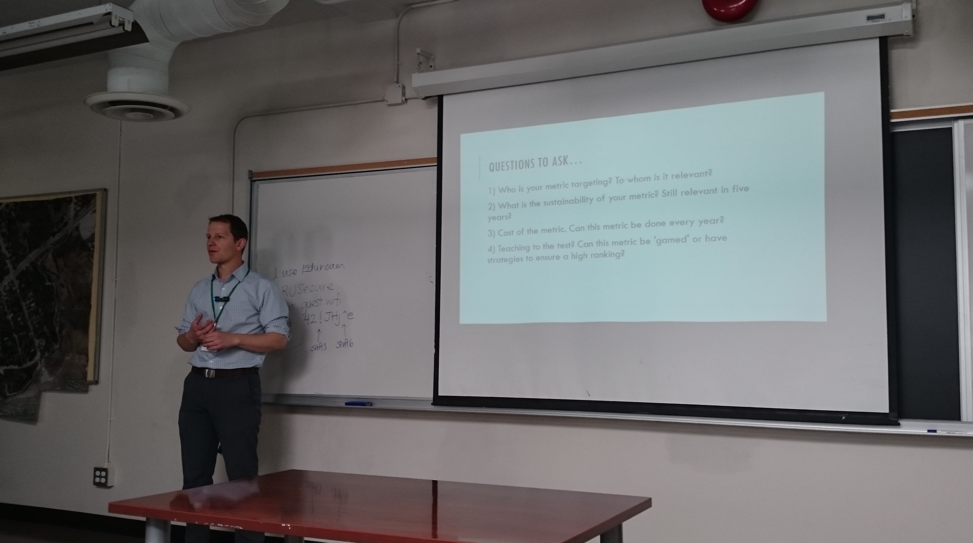
Join Peter Johnson as he kicks off day two of Geothink’s 2016 Summer Institute by inviting students to dream that they are civil servants at the City of Toronto when the city receives a hypothetical “F” rating for its open data catalogue. From this starting premise, Johnson’s lecture interrogates how outside agencies, academics, and organizations evaluate municipal open data programs. In particular, he discusses problems with current impact studies such as the Open Data 500 and what other current evaluation techniques look like.
Geothoughts Talk 5: The Value of Open Data: A Legal Perspective
Teresa Scassa starts our fifth talk by discussing how those working in the discipline of law don’t usually participate in the evaluation of open data. While those in law don’t actually evaluate open data, however, legal statutes often are responsible for mandating such valuation, she argues. In particular, legal statutes often require specific types of data to be open. Furthermore, provisions in Canadian law such as the Open Courts Principle mean that many aspects of Canada’s legal system can be open-by-default.
Geothoughts Talk 6: Open Data: Questions and Techniques for Adding Civic Value
Pamela Robinson dispels the notion that open data derives value from economic benefits by instead discussing how such data can be used to fundamentally shift the relationship between civil society and institutions. She elaborates on this idea by noting that not all open data sets are created equal. Right now, she argues, the mixed ways in which open data is released can dramatically impact whether or not it’s useful to civic groups hoping to work with such data.
Geothoughts Talk 7: Measuring the Value of Open Data
In a talk that helps to summarize the previous three presenters, Renee Sieber discusses the different ways in which open data can be evaluated. She details many of the common quantitative metrics used—counting applications generated at a hackathon, the number of citizens engaged, or the economic output from a particular dataset—before discussing some qualitative indicators of the importance of a specific open data set. Some methods can likely capture certain aspects of open data better than others. She then poses a series of questions on how one can actually attach a value to the increased democracy or accountability gained by using open data.
If you have thoughts or questions about these podcasts, get in touch with Drew Bush, Geothink’s digital journalist, at drew.bush@mail.mcgill.ca
Day two of Geothink’s 2016 Summer Institute began with short lectures on specific disciplinary perspectives on open data. Teresa Scassa, Canada Research Chair in Information Law at the University of Ottawa, gave a legal perspective on the value of open data.
By Drew Bush
Day two of the 2016 Summer Institute began with presentations from Geothink’s faculty that aimed to provide different disciplinary approaches to evaluating open data. Armed with this information, students spent the rest of the day working in groups to first create measures to value open data, and, second, role-play how differing sectors might use a specific type of data.
The morning began with 30-minute presentations from members of Geothink’s faculty. Peter Johnson, an assistant professor at Waterloo University’s Department of Geography and Environmental Planning, led off with a presentation on how municipal governments evaluate the success of their open data programs.
“This is the situation that we sort of find ourselves in when it comes to evaluating open data,” Johnson told students. “There’s this sort of world outside of government that’s bent on evaluating open data. And those are people like me, academics, those are non-profits, those are, you know, private sector organizations who are looking at open data and trying to understand how is it being used. So this is kind of, I think, a sign that open data has arrived a little bit. Right? It’s not just this sort of dusty, sort of nerdy cobweb in the corner of the municipal government basement. It’s something that other people are noticing and other people are taking an interest in.”
Johnson was followed by Teresa Scassa, Canada Research Chair in Information Law at the University of Ottawa, with a legal perspective on the value of open data. Pamela Robinson, associate professor in Ryerson University’s School of Urban and Regional Planning, gave a civic-oriented approach to the value of open data, one that was intentionally at odds with the private sector.
“I’ll be really blunt, I’m not that interested in making money from open data,” Robinson told students in regard to the common municipal reason for opening data. “It’s important but it’s not my thing. As an urban planner, my primary preoccupation is about citizen’s relationships with their government. And I’m interested in the proposition that open data as an input into open government can fundamentally shift the relationship between civil society and institutions.”
Each of these short lectures were part of a comprehensive look at open data during the three-day institute. Students at this year’s institute learned difficult lessons about applying actual open data to civic problems and on how to evaluate the success of an open data program. In between activities on day two, students also heard from a panel of municipal officials and representatives of Toronto-based organizations working with open data.
Held annually as part of a five-year Canadian Social Sciences and Humanities Research Council (SSHRC) partnership grant, each year the Summer Institute devotes three days of hands-on learning to topics important to research taking place in the grant. This year, each day of the institute alternated lectures and panel discussions with work sessions where instructors mentored groups one-on-one about the many aspects of open data.
But many students struggled not only with thinking about how to evaluate the open data that they were working with, but also with how to determine the impact of any project that utilizes such an information source.
“I think a big challenge that I personally am facing is this idea of it’s supposed to have real improvement for society, it’s suppose to help society,” Rachel Bloom, from McGill University, said. “But we find that a lot of vulnerable populations actually won’t have access to these applications and the technology. So it’s kind of like trying to reconcile this idea of helping while also being aware that like maybe you are not actually reaching the population you are trying to help. Which is kind of what openness is about—is actually engaging the people personally.”
It is for such reasons that evaluating open data can be quite nuanced—an idea represented in student group presentations on the topic. The presentations varied greatly with some student groups choosing metrics based on the things that a community might value and then establishing an outside monitor to observe datasets and report back to the community. Other students established a workflow to harness citizen input to evaluate open data through instruments such as online surveys.
Group one evaluated open data metrics based on whether they were representative of a community.
Group two established a workflow to harness citizen input to evaluate open data through instruments such as online surveys.
Group three took on the role of being an independent watch dog auditing open data based on public engagement.
Group four utilized a framework for evaluating open data that came from the Canadian Standards Association.
Group five sought to measure open data portals by the quality of the data they provide.
Group six argued that each open data set is unique and therefore concluded one standard would not work for them all but that citizen engagement may provide insight.
An afternoon panel comprised of local city officials and representatives from groups concerned with open data discussed the practical side of publishing, using, and evaluating open data as it stands today. The panel included Keith McDonald, former open data lead for City of Toronto; Bryan Smith, co-founder and Chief-Executive-Officer of ThinkData Works; Marcy Burchfield and Vishan Guyadeen, from The Neptis Foundation; And, Dawn Walker and Curtis McCord, Geothink students from University of Toronto who designed the Citizen’s Guide to Open Data.
Two of the primary concerns shared by panelists included the lack of standards for which differing municipalities provide open data, and the gap that exists between how open data is provided and what businesses or citizens require to actually use it. Smith spoke of how early visions of students and application developers using open data to radically transform life in cities have not scaled up to the national level particularly well.
“What we are seeing, which I don’t think anyone predicted, is the large companies—mostly companies that run a bunch of apps that probably everyone here has on their phones—are the ones who are the biggest purveyors of open data,” Smith told students. Issues with the type and quantity of data (as well as differences between how data is provided in different places) have limited other players and even some of these big developers too.
For more on this discussion, check out an excerpt of the panel discussion below. We pick up the discussion as the panelists talk about standards in relation to the Open Government Partnership.
In role-playing activities, students considered the issues raised by the panel as well as the practical problems citizens or other groups might face in finding the open data they require. Concluding presentations included those from students playing the role of real estate developers, non-profits concerned with democracy, and a bicycle food courier service.
Stay tuned for the full audio of each professors’ talk presented as podcasts here. Also check back on Geothink for a synopsis of day three, and, of course, watch more of our video clips (which we’ll be uploading in coming days) here.
If you have thoughts or questions about this article or the videos, get in touch with Drew Bush, Geothink’s digital journalist, at drew.bush@mail.mcgill.ca.
For her Ph.D. research, Victoria Fast explored how urban food assets can be crowdsourced onto the geoweb — civic participation in action.
All cylinders were firing by the time we wrapped up our Nov. 23 Twitter chat on meaningful civic participation on the geoweb. There were many parallel conversations that we hope will continue among participants and the wider Geothink community into the future. Here we share a few highlights, as well as a transcript of the chat.
We should ask what criteria define “civic participation”? Even passive or unknowing involvement may qualify as meaningful participation.
Intermediaries (infomediaries) are major mediators of the geoweb — leading projects, supporting learning, and providing citizens with tools and open data access. Librarians were identified as important infomediaries.
The geoweb can enable citizen participation on all levels of ‘meaning’. Yet we need to be mindful of who is being left out & not blame the excluded.
There can be different benefits from short-term engagements such as hackathons and long-term involvement such as contributing to OpenStreetMap. But both can trigger enduring civic interest.
It can be useful to consider when geoweb contributions using open data do not qualify as civic participation.
Both time-decay (sustainability) and distance-decay (activities concentrating around intermediary’s location) are issues that can affect civic participation on the geoweb.
Transcript
Hi all. Our chat is underway! It will last ~1hr. By way of intro's, are you a #geoweb participant? How so? Pls. respond using #Geothink.