Author Archives: Drew Bush

Geothoughts 9: Geothink Project Measures Open Data Standards for Consumer and Publisher Uses

Geothink's Open Data Standards Project helps publishers and consumers better use open data.

Geothink’s Open Data Standards Project helps publishers and consumers better use open data.

By Drew Bush

We’re very excited to present you with our ninth episode of Geothoughts. You can also subscribe to this Podcast by finding it on iTunes.

In this episode, we examine a Geothink project on open data that officially kicked off in February 2015 with a Geothink teleconference call. Project lead Rachel Bloom, an undergraduate student in the Geothink Rapid Response Think Tank at McGill University, began this research one year ago. She worked with Geothink Head Renee Sieber, associate professor in McGill University’s Department of Geography and School of Environment.

It recently culminated in a white paper written on two spread sheets (1) an examination of high-value open datasets Canadian cities use; And (2) an inventory of open data standards published by open data providers. Listen in as Bloom explains to partners who publish open data how to know what standards exist and who uses them for which datasets.

Thanks for tuning in. And we hope you subscribe with us at Geothoughts on iTunes. A transcript of this original audio podcast follows.

TRANSCRIPT OF AUDIO PODCAST

Welcome to Geothoughts. I’m Drew Bush.

[Geothink.ca theme music]

“This project is about investigating open data domain specific standards at the Canadian municipal level, which I guess is kind of a mouthful. But basically I’ve created two spreadsheets to figure out how Canadian municipalities are publishing their data and how the level of conformity is per the guidelines for open data standards.”

That’s Rachel Bloom, an undergraduate student in Geothink’s Rapid Response Think Tank at McGill University, talking about domain specific data from sectors like transportation and city budgets. She’s working with Geothink Head Renee Sieber, associate professor in McGill University’s Department of Geography and School of Environment.

“To begin this project I chose ten domains to focus on. These domains came from open knowledge foundation spreadsheets. They are considered high value, and I thought these were interesting. I thought they were important to public use. So I chose them as the basis to create these spreadsheets.”

In late February, Bloom conducted a teleconference for the project’s partners in several Canadian cities. In it, Bloom discusses the project, each spreadsheet, and answers questions from those on the call. She starts with the first spreadsheet.

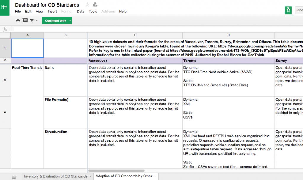
“It’s called ‘Adoption of Open Data Standards By Cities.’ So what we did for this is we have the 10 domains on the side on the y-axis, and then we have kind of nested between these certain metrics of how the municipality names the dataset, the file format, the structuration of the data, any metadata associated with the dataset or description of the data, and if theses data sets for each domain are already using specific data standards—open data standards. And these were taken from each municipality’s open data catalogues.”

“And it helped for eventually comparing whether the ways that data is being published is even kind of compatible with the semantic and schematic guidelines dictated by available open data standards.”

Participants then examined a specific example from the spreadsheet, building permits for the City of Toronto. The call then proceeded to the next spreadsheet developed.

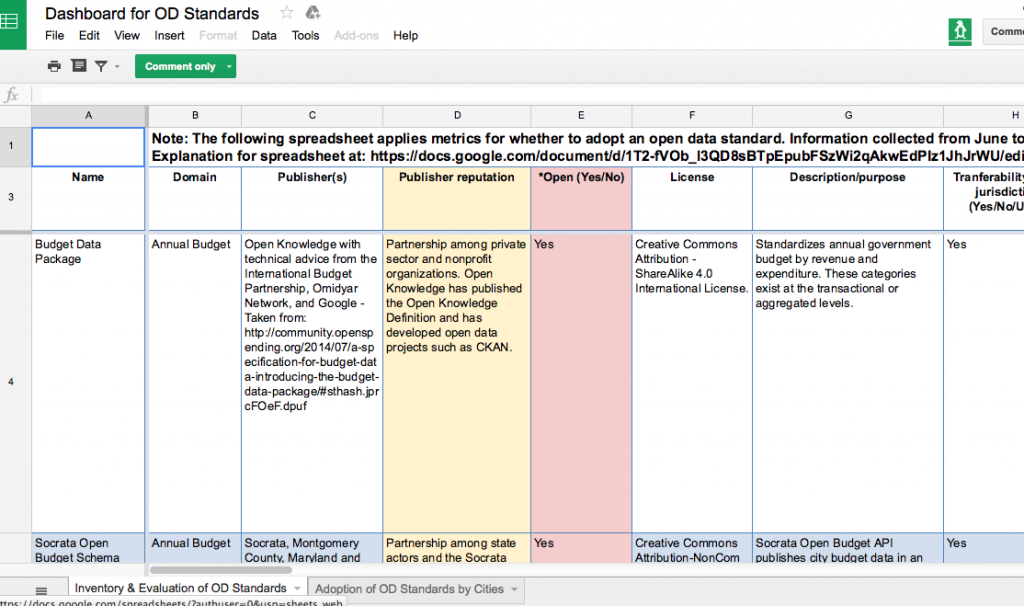
“It’s called ‘Inventory and Evaluation of Open Data Standards.’ Here we have on the y-axis these are individual open data standards that are kind of domain specific so they are pegged to certain domains and they cover the ten domains used for the other table. Though there is two extra domains…the metrics you find kind of on the top, are an innovation on my part. They were chosen by me based on the demand of data publishers and consumers I found in my research which came from all different types of mediums.

“I’ve even read e-mail correspondences of people talking about what they want when they are structuring their datasets. They also come from reinforcing that these standards are open. So what does it mean to be open? They have to be open, they have to be consensus driven, they have to have to multi-stakeholder participation so theirs metrics have to account for that.”

Bloom again takes participants through a specific example, this time a budget data package, going through all the metrics to give participants a sense of the quality of standard in terms of making data interoperable. When she finishes, Linda Low, Open data lead for the City of Vancouver, interrupts her to ask:

“Rachel can you talk a little about the criteria for whether or not it’s open or not again, it’s whether multi-stakeholders contribute to it, and there was something else too, right, that you said?

“So when we talk about multi-stakeholders we’re talking about people who contribute that are from different facets of society. So the private sector, the public sector, civil societies, and also the obvious which is that open implies that there should be no royalties or fees associated with using the standard. It should be repurposable, they should be able to extend it how they wish, it should have a license that is open so that there is legal ramification for using the standard as you please. You’re right it’s not explicitly mentioned which of these kind of contribute to defining openness but all of these are good fundamental metrics for an open standard I would think.”

The teleconference proceeds as Bloom and the call’s participants discuss the spreadsheets and white paper, stopping to elaborate on specific examples or details in more depth. Toward the end of the 40-minute call, Bloom shares the vision and goals for this project.

“There’s metrics that can help publishers, but there’s also metrics that can help consumers who would want to voice how they want to structure the data which is really part of the open process. So I think it can be used as multiple, for multiple purposes, really so it’s flexible in that way. So I’m not sure if there’s a very specific way of using it cause it really depends on the goals of the person using the resource.”

She’s followed-up by Sieber who firsts asks a question and then provides insight into how the project’s goals were determined.

“A standard is likely to be viewed much differently if you want to do something for internal government use like business intelligence as oppose to external use. And depending upon the audience, if you’re doing something for realtors it might be viewed quite differently than if you’re trying to do it for, I don’t know, low information voters.”

At the conclusion, Low offers the municipal publishers perspective on how constantly updated and revised standards make it hard to know which one a municipality should adopt in differing domains such as city budgets, crime statistics, or waste removal services.

“When do we say this is justifiable for us without doing a whole bunch of research and wasting the effort afterward. That was the thing I always keep struggling about.”

Bloom doesn’t hesitate with an answer.

“There are so many options too and ways of approaching it. I mean, I don’t know–it’s really about the interests of the person who is publishing the data and the goals. I think at the end of the day, it’s going to, different governments are going to have reconcile what their goals are and how they want to go about it. Which is the hardest part.”

This project is ongoing and next steps will continue to look at the landscape of open data standards in Canada.

[Voice over: Geothoughts are brought to you by Geothink.ca and generous funding from Canada’s Social Sciences and Humanities Research Council.]

###

If you have thoughts or questions about this podcast, get in touch with Drew Bush, Geothink’s digital journalist, at drew.bush@mail.mcgill.ca.

Inside Geothink’s Open Data Standards Project: Standards For Improving City Governance

By Rachel Bloom

Rachel Bloom is a McGill University undergraduate student and project lead for Geothink’s Open Data Standards Project.

In February, I led a Geothink seminar with city officials to introduce the results of our open data standards project we began approximately one year earlier. The project was started with the objective of assisting municipal publishers of open data in standardizing their datasets. We presented two spreadsheets: the first was dedicated to evaluating ‘high-value’ open datasets published by Canadian municipalities and the second consisted of an inventory of open data standards applicable to these types of datasets.

Both spreadsheets enable our partners who publish open data to know what standards exist and who uses them for which datasets. The project I lead is motivated by the idea that well-developed data standards for city governance can grant us the luxury of not having to think about the compatibility of technological components. When we screw in a new light bulb or open a web document we assume that it will work with the components we have (Guidoin and McKinney 2012). Technology, whether it refers to information systems or manufactured goods, relies on standards to ensure its usability and dissemination.

Municipal governments that publish open data look to the importance of standards for improving the usability of their data. Unfortunately, even though ‘high-value’ datasets have increasingly become available to the public, these datasets currently lack a consensus about how they should be structured and specified. Such datasets include crime statistics and annual budget data that can provide new services to citizens when municipalities open such datasets by publishing them to their open data catalogues online. Anyone can access such datasets and use the data however they wish without restriction.

Civic data standards provide agreements about semantic and schematic guidelines for structuring and encoding the data. Data standards specify technical data elements such as file formats, data schemas, and unique identifiers to make civic data interoperable. For example, most datasets are published in CSV or XML formats. CSV structures the data in columns and rows, while XML encapsulates the data in a hierarchical tree of <tags>.

They also specify common vocabularies in order to clarify interpretation of the data’s meanings. Such vocabularies could include, for example, definitions for categories of expenditure in annual budget data. Geothink’s Open Data Standards Project offers publishers of open data an opportunity to improve the usability and efficiency of their data for consumers. This makes it easier to share data across municipalities because the technological components and their meanings within systems will be compatible.

Introducing Geothink’s Open Data Standards Project
No single, clear definition of an open data standard exists. In fact, most definitions of an ‘open data standard’ follow two prevailing ideas: 1) Standards for open data; 2) And, open standards for data. Geothink’s project examines and relates together both of these prevailing ideas (Table 1). The first spreadsheet, the ‘Adoption of Open Data Standards By Cities’, considers open data and its associated data standards. The second spreadsheet, the ‘Inventory of Open Data Standards,’ considers the process of open standardization. In other words, we were curious about what standards are currently being applied to open municipal data, and how to break down and document open standards for data in a way that is useful to municipalities looking to standardize their open data.

Table 1: Differences between ‘open data’ standards and open ‘data standards’

Requires open data Requires open standard process
Evaluation of ‘High-Value’ Datasets Yes No
Inventory of Open Data Standards No Yes

The project’s evaluation of datasets relates to standards for open data. Standards for open data refer to standards that, regardless of how they are developed and maintained, can be applied to open data. Open data, according to the Open Knowledge Foundation (2014), consists of raw digital data that should be freely available to anyone to use, repurposable and re-publishable as users wish, and absent mechanisms of control like restrictive licenses. However, the process of developing and maintaining standards for open data may not require transparency nor include public appeals for its development.

To discover what civic data standards are currently being used, the first spreadsheet, Adoption of Open Data Standards By Cities, evaluates ‘high value’ datasets specific to 10 domains (categories of datasets such as crime, transportation or or service requests) in the open data catalogues for the cities of Vancouver, Toronto, Surrey, Edmonton and Ottawa. The types of data were chosen based on the Open Knowledge Foundation’s choice of datasets considered to provide greatest utility for the public. The project’s spreadsheet notes salient structuring and vocabulary of each dataset; such as the name, file format, schema, and available metadata. It especially notes which data standards these five municipalities are using for their open data (if any at all).

With consultation from municipal bodies and organizations dedicated to publishing open data, we developed a second spreadsheet, Inventory and Evaluation of Open Data Standards,  that catalogues and evaluates 22 open data standards that are available for domain-specific data. The rows of this spreadsheet indicate individual data standards. The columns of this spreadsheet evaluate background information and quality for achieving optimal interoperability for each of the listed standards. Evaluating the quality of the standard’s performance, such as whether the standard is transferable to multiple jurisdictions, is an important consideration for municipalities looking to optimally standardize their data. Examples of open data standards in this inventory are BLDS for building permit data and the Budget Data Package for annual budget data.

The project’s second spreadsheet is concerned with open standards for data. Open standards, as opposed to closed standards, requires a collaborative, transparent, and consensus-driven process to maintain its development (Palfrey and Gasser, 2012). Therefore, open standards honor a commitment to processes of transparency, due process, and rights of appeal. Similarly to open data, open standards resist processes of unchecked, centralized control (Russell, 2014) . Open data standards make sure that end users do not get locked into a specific technology. In addition, because open standards are driven by consensus, they are developed according to the needs and interests of participatory stakeholders. While we provide spreadsheets on both, our project advocates implementing open standards for open data.

In light of the benefits of open standardization, the metrics of the second spreadsheet note the degree of openness for each standard. Such indicators of openness include multi-stakeholder participation and a consensus-driven process. Openness may be observed through the presence of online forums to discuss suggestions or concerns regarding the standard’s development and background information about each standard’s publishers. In addition, open standards use open licenses that dictate the standards may be used without restriction and repurposable for any use. Providing this information not only allows potential implementers to be aware of what domain-specific standards exist, but also allows them to gauge how well the standard performs in terms of optimal interoperability and openness.

Finally, an accompanying white paper explains the two spreadsheets and the primary objective of my project for both publishers and consumers of open data. In particular, it explains the methodology, justifies chosen evaluations, and notes the project’s results.  In addition, this paper will aid in navigating and understanding both of the project’s spreadsheets.

Findings from this Project
My work on this project has led me to conclude that the majority of municipally published open datasets surveyed do not use civic data standards. The most common standard used by municipalities in our survey was the General Transit Feed Specification (GTFS) for transit data and the Open311 API for service request data. Because datasets across cities and sectors vary formats and structure, differences in them coupled with a lack of cohesive definitions for labeling indicate standardization across cities will be a challenging undertaking. Publishers aiming to extend data shared among municipalities would benefit from collaborating and agreeing on standards for domain-specific data (as is the case with GTFS).

Our evaluation of 22 domain-specific data standards also shows standards do exist across a variety of domains. However, some domains, such as budget data, contain more open data standards than others. Therefore, potential implementers of standards must reconcile which domain-specific standard best fits their objectives in publishing the data and providing the most benefits for public good.

Many of standards also contain information for contacting the standard’s publishers along with online forums for concerns or suggestions. However, many still full information regarding their documentation or are simply in early draft stages. This means that although standards exist, some of these standards are in their early stages and may not be ready for implementation.

Future Research Pathways
This project has room for growth so that we can better our partners who publish and use open data decide how to go about adopting standards. To accomplish this goal, we could add more cities, domains, and open standards to the spreadsheets. In addition, any changes made to standards or datasets in the future must be updated.

In terms of the inventory of open data standards, it might be beneficial to separate metrics that evaluate openness of a standard from metrics that evaluate interoperability of a standard. Although we have emphasized the benefits of open standardization in this project, it is evident that some publishers of data do not perceive openness as crucial for the successfulness of a data standard in achieving optimal interoperability.

As a result, my project does not aim to dictate how governments implement data standards. Instead, we would like to work with municipalities to understand what is valued within the decision-making process to encourage adoption of specific standards. We hope this will allow us to provide guidance on such policy decisions. Most importantly, to complete such work, we ask Geothink’s municipal partners for input on factors that influence the adoption of a data standard in their own catalogues.

Contact Rachel Bloom at rachel.bloom@mail.mcgill.ca with comments on this article or to provide input on Geothink’s Open Data Standards Project.

References
Guidoin, Stéphane and James McKinney. 2012. Open Data, Standards and Socrata. Available at http://www.opennorth.ca/2012/11/22/open-data-standards.html. November 22, 2012.
Open Knowledge. Open Definition 2.0. Opendefinition.org. Retrieved 23 October 2015, from http://opendefinition.org/od/2.0/en/
Palfrey, John Gorham, and Urs Gasser. Interop: The promise and perils of highly interconnected systems. Basic Books, 2012.
Russell, Andrew L. Open Standards and the Digital Age. Cambridge University Press, 2014.

Geothink Summer Institute to Kick Off May 9, 2016

Geothink’s 2016 Summer Institute will take place at Ryerson University in downtown Toronto.

By Drew Bush

Are you curious about the use of open data by municipalities and their citizens? Geothink’s 2016 Summer Institute will kick off May 9 to May 11 at Ryerson University in Toronto and combine practical data handling and communications skills with a unique breadth of critical discussions.

“We’re really excited about the structure this year, where students will be able to get their hands dirty with open data and then get to learn and interrogate how it’s made,” Geothink Project Manager Alexander Taciuk said.

The first day will be headed by the Open Data Iron Chef Richard Pietro and students will accelerate from learning the basics of open data to developing open data-fuelled solutions to real world problems. On the second day, lectures and discussions with open data experts will give students unique perspectives on and access to Toronto’s open data makers and doers. The final day will be a writing skill-incubator that combines writing tips “that no one ever teaches you in school” to teach how to communicate a clear message.

Hands-on group work will be interspersed with speakers exploring topics on local and Canadian issues. The Summer Institute aims to give all attendees a multifaceted perspective on the value of open data, and will include hands-on data exploration, hearing from Geothink professors and experts, and discussions with key members of the Toronto open data community.

“It’s essential that students appreciate the many definitions of open in open data and the numerous ways in which open data can be valued,” said Geothink Head Renee Sieber, associate professor in McGill University’s Department of Geography and School of Environment. “This Summer Institute will give students approaches to measure quantifiable values like economic development and business intelligence as well as the less quantifiable values such as democracy, participation, transparency, and accountability.”

The institute will be held at one of the Ryerson planning studios at the Ryerson School of Urban and Regional Planning. It is open to Geothink students at all levels, undergrad to post-doc. If you are graduating this April, or starting new next term, you are also welcome to attend.

“I’m excited to be bringing the Geothink students together once again to tackle an idea from a variety of angles,” Suthee Sangiambut, Geothink Summer Institute organizer and newsletter editor, said. “I know the variety in expertise each student brings and I expect the Summer Institute to be a forum for ideas and a great collaborative learning experience. The more Geothink students present, the better the discussion will be. Guaranteed.”

The summer institute is hosted by Geothink, a five-year partnership grant awarded by the Canadian Social Sciences and Humanities Research Council (SSHRC) in 2012. The partnership includes researchers in different institutions across Canada, as well as partners in Canadian municipal governments, non-profits and the private sector. The expertise of our group is wide-ranging and includes aspects of social sciences as well as humanities such as: geography, GIS/geospatial analysis, urban planning, communications, and law.

If you have thoughts or questions about the article, get in touch with Drew Bush, Geothink’s digital journalist, at drew.bush@mail.mcgill.ca.

Geothink Program Guide for the American Association of Geographers (AAG) 2016 Annual Meeting

By Drew Bush

The Annual Meeting of the American Association of Geographers will be in San Francisco, CA from March 29 to April 2.

The Annual Meeting of the American Association of Geographers will be in San Francisco, CA from March 29 to April 2.

A large number of Geothinkers will be presenting at this year’s American Association of Geographers (AAG) Annual Meeting in San Francisco, CA the last week in March. You won’t want to miss two of our co-applicants and one of our students making presentations on Tuesday in the 10:00 AM session Data in action: Tracing the open data experiment. Other highlights include Renee Sieber and Sarah Elwood as panellists in Gender & GIScience.

Below we’ve compiled the schedule for all of Geothink’s co-applicants, collaborators and students who will be presenters, panelists, organizers, and chairs during the conference. Find a PDF of this program here. We hope you find this useful for finding the right sessions to join. You can also find the full searchable preliminary AAG program here.

If you’re not able to make the conference, you can follow along on Twitter and use our list of Twitter handles below to join the conversation with our participants.

Join the Conversation on Twitter:
Alex Aylett: @openalex_                   Peter Johnson: @peterajohnson
Tenille Brown: @TenilleEBrown      Pamela Robinson: @pjrplan
Jonathan Corbett: @joncorbett      Teresa Scassa: @teresascassa
Sarah Elwood: @SarahElwood1      Renee Sieber: @RE_Sieber
Victoria Fast: @VVFast                      Suthee Sangiambut: @notgregorypeck
Sara Harrison: @Sara_Harrison79  Scott Bell: @scottyBgeo
Stéphane Roche: @Geodoc31

And remember to use the conference hashtag #AAG2016 and our hashtag #Geothink or handle @geothinkca when you Tweet.

Come to our Sessions at AAG 2015:

Tuesday, March 29

Wednesday, March 30

Thursday, March 31

Friday, April 1

Saturday, April 2

If you have thoughts or questions about this article, get in touch with Drew Bush, Geothink’s digital journalist, at drew.bush@mail.mcgill.ca.

Image Source: Zheng Zeng, Creative Commons 4.0

Gethoughts 8: How Technology is Reshaping Citizen Interactions on Climate Change

pic32-e1435343808697

Hydro Quebec is setting up a new circuit of public electric charging stations, one of many changes in the works as cities across Canada prepare for more environmentally friendly futures.

By Drew Bush

We’re very excited to present you with our eighth episode of Geothoughts. You can also subscribe to this Podcast by finding it on iTunes.

In this episode, we examine what role Canada’s cities play in international solutions to climate change as well as how new technologies shape interactions in neighbourhoods and between neighbours on environmental issues. In it, we talk with Geothink researcher Alexander Aylett, a professor and researcher at the Institut national de la recherche scientifique.

Thanks for tuning in. And we hope you subscribe with us at Geothoughts on iTunes. A transcript of this original audio podcast follows.

TRANSCRIPT OF AUDIO PODCAST

Welcome to Geothoughts. I’m Drew Bush.

[Geothink.ca theme music]

Last week on Geothink.ca, we brought you a look at how open data and digital technology are reshaping the way cities plan for sustainable futures and how to act on issues such as climate change. Today we dive deeper into the changes taking place locally and internationally on this topic.

“One of the things I’m most excited about here in Montreal, is electrification of mobility in the city. So something in the order of 40 percent of Montreal’s GHG emissions come from moving people and things around in the city. Trucks, cars, trains—to a certain extent—all of those things. And what we’re seeing now is a real scaling up of, I guess, work that’s been happening over the past four or five years to electrify as much of that as we can.”

That’s the opinion of one expert who has been studying these issues from his office in Montreal, Quebec. We spoke with him over Skype this month.

“Alexander Aylett, I’m a professor of urban sustainability governance and innovation at the Center for Urbanization, Culture, and Society of the National Institute for Scientific Research or the proper French title is Institut National de la Recherche Scientifique in Montreal.”

Aylett believes the time has come for changes that make transit, buildings, and energy more efficient in cities. That’s because cities can play an outsized role in confronting the important environmental issues of today by mixing a curious blend of new technology, empowered citizen groups, and long-term planning. The first signs heralding these changes are here.

“So we have Hydro Quebec that’s setting up la route verte où route bleu of publicly accessible charging points. And it started of with like two, three, four, five and you know now we’re aiming for a few thousand in the city within the next couple of years. And we’re seeing the launch of things like Téo taxi, where there is going to be, their plan, is—if I’m right about their deadlines—by next December is to have something like 2,000 new electric vehicles on the roads of Montreal. So a big private player dramatically increasing the number of electric vehicles that we’ve got on the roads. Similar action happening in big players like CommunAuto.” 

Such changes are not purely financial. Cultural shifts have occurred before in Montreal. Not long ago when the city began planning for the introduction of Bixi bike sharing, they didn’t tinker around the margins. Instead they created many more bike paths that were safer for riders and that have since been adopted by many residents. On environmental issues like climate change a similar transition may soon take place.

“We’ll see gas burning vehicles sort of being retired. New institutional players like taxis, for example, buying electric. Private citizens buying electric. But also private citizens realizing that the increased convenience of smart taxi services like Uber, and Téo, and Car-to-go, and other car sharing networks means that people don’t need to have a private vehicle in a lot of cases anymore. People who are sort of on the borderline zone of needing a car regularly but not every morning for their commute I think will be in a position to just abandon the private automobile in favor of convenient access to different mobility providers.”

Such changes would bode well for those who would see Canada reduce greenhouse gas emissions or GHGs. More cooperation is needed between actions taken by cities and those being coordinated on national and international levels. The 2015 Paris Agreement and the prominent role of cities in it means such a future is not just possible but likely, according to Aylett.

“Coming out of COP21 what we have is a much more open understanding of the fact that cities are a critical partner for states, provinces, and national governments. And I think—and this is why it’s such an exciting period right now, like particularly this next sort of six months—I think that we what we should be seeing is more effective partnerships between those different players. More funding coming down especially in Canada given the commitments our government has to fund urban infrastructure projects…Spreading from city to city to city effective interventions into different aspects of our urban environmental footprints. That’s fantastic.”

In a future where cities help solve climate change, different cities will each contribute a piece of the solution. In Montreal it may be innovations in transport technology and the manner in which individuals book transit, Vancouver may continue leading in green building efforts that incorporate “reach codes” so each step in efficiency serves to enhance the next, and Toronto may utilize new models and data to better plan where to locate parks and green roofs.

Some technological changes will undoubtedly allow citizens to contribute their expertise and opinions to solutions while others will focus on overcoming small barriers in daily life that could have a dramatic impact on environmental issues such as climate change.

“Basically we’re talking about reducing friction and reducing barriers to use where the simplicity of jumping into your car, and driving somewhere—even if in the end it creates congestion, it’s an un-enjoyable experience—it’s almost a knee-jerk reaction for some people because it’s so simple. And the public transit in some situations is more complex because you need to transfer, you need to use, maybe you need to use Bixi and the Metro and the bus. Things that are when you look at it seems more complicated. But having an interface like Transit App that just lays it all out for you means that from a user point of view, it reduces the barrier to switching from one type of behavior—driving in your car—to another type of behavior—which is getting there by any other, you know, means of mobility.”

“And the next phase of that, and this is something that we’re seeing already being considered in some places, like Singapore for example, is just to stop charging people for individual modes of transportation and start charging people for reaching their destination. And so the difference would be you open up your app, for example, and say, ‘I’m here and I need to get there.’ And the application uses smart open data about different modes of transportation to calculate for you a couple of different routes and charges you for the route. And so you just pay to get from your house to school or from your house to work or from your house to the art gallery.”

But that’s not all. New information technologies and open data platforms have a habit of helping citizens to organize to solve problems. Environmental issues like climate change are no different once the right data sets and support are in place.

“If you wanted to start talking about how you can manage a community energy transition, having good online platforms that are a tool that’s used in public mobilization and engagement strategies makes it possible to be more effective at the local level but also then to scale up quite well from local action to action in other local areas either in the same city or other cities.”

Aylett believes that such networked communities can bring together individuals who may have never known each other on topics of mutual concern. Such collaborative work can lead to a snowballing effect where changes to how cities respond to environmental issues might some day become inevitable.

[Geothink.ca theme music]

[Voice over: Geothoughts are brought to you by Geothink.ca and generous funding from Canada’s Social Sciences and Humanities Research Council.]

###

If you have thoughts or questions about this podcast, get in touch with Drew Bush, Geothink’s digital journalist, at drew.bush@mail.mcgill.ca.


Geothoughts Conversations 2: The Nature of Democracy in the Age of Open Data

Geothoughts Conversations 2 explores the nature of democracy in an age of open data.

Geothoughts Conversations 2 explores the nature of democracy in an age of open data.

By Drew Bush

The largest grant investigating two-way exchanges of locational information between citizens and their city governments, Geothink makes possible countless collaborations and discussions. This month, Geothoughts Conversations brings you a look at one such conversation that took place this past January on the wintry downtown campus of McGill University in Montreal, QC.

We sat down with Geothink head Renee Sieber, associate professor in McGill University’s Department of Geography and School of Environment, and Daniel Paré, associate professor in the Department of Communication and School of Information Studies at the University of Ottawa, where he also serves as an associate director at the Institute for Science, Society, and Policy.

The topics: The nature of democracy and public participation and, later, how city platforms that utilize open data impact democratic processes and citizen engagement. Often hailed as a panacea for making government transparent and the political process more open and inclusive, Paré and Sieber discuss the inaccuracies in this narrative along with how open data has changed the roles of cities and citizens in today’s democracies.

To start us off Sieber dispels the idea that democracy itself requires public participation and discusses the wide spectrum of democractic systems that exist.

Thanks for tuning in. And we hope you subscribe with us at Geothoughts on iTunes.

If you have thoughts or questions about this podcast, get in touch with Drew Bush, Geothink’s digital journalist, at drew.bush@mail.mcgill.ca.

Envisioning An Environmentally Sustainable Urban Future Using Clean Digital Technologies


By Drew Bush

Imagine a world where electric taxis crowd Montreal’s downtown streets, green buildings efficiently manage energy consumption for Vancouverites, and Toronto’s city leaders monitor differences in neighbourhood surface heat emissions to best position green roofs. Now imagine the environmental and social impacts of such shifts when scaled-up for all of Canada’s cities.

That future—one that makes use of digital technology, citizen-sensors, and open data to manage urban areas more sustainable—may already be here according to some experts. In coming years, the company Téo taxi will bring the first fleet of electric taxis to Montreal’s streets while Hydro Quebec has also begun work to bring thousands of electric charging stations to the province of Quebec.

Globally, changes triggered by digital technologies and open data have already begun to impact how city leaders make decisions and engage with communities on environmental issues. One outcome of these new mediums for exchanging information has been enhanced capacity of cities to use citizens and resources to strategically tackle issues such as climate change.

I think it will be a noticeable difference on the streets of Montreal when you walk out and you see the white and green Téo taxis you know all through the downtown core,” said Geothink researcher Alexander Aylett, a professor and researcher at the Institut national de la recherche scientifique.You know we’re talking about a really large pool of electric vehicles. And the shift is an environmental one, but it’s also a social and a cultural one where people start to have direct experience with electric mobility. It will be really profound.”

Aylett noted that 40 percent of Montreal’s greenhouse gas (GHG) emissions derive from moving people and things around the city. Efforts to scale-up the ability of cities across Canada to manage and change truck, car, and train traffic is one of several goals city leaders across North America are pursuing, he added in a recent interview with Geothink.ca.

“So instead of just having one city that’s really strong in transit and another city that’s really strong in green buildings, we are seeing a shift—I think it’s a slow shift but I think we’re headed in that direction—where cities are approaching sustainability and trying be leaders in multiple sectors,” Aylett said. “So buildings, transit, energy—all of it.”

The City of the Future

City leaders around the world are aware that municipalities themselves only control a very small percent of the urban infrastructure that directly and indirectly can lead to environmental damage. Cities also cause environmental damages well beyond their geographic scope making it more difficult for them to reduce impacts. Consequently, solutions that rely on taxation or legislation may have limited ability to dramatically shift the myriad social behaviors tied to environmental issues like climate change.

Technology makes possible not only harnessing the individual abilities of citizens—think transit engineers, architects, and software developers—in networked communities but also new understandings of how urban systems impact local and international environmental problems.

Take, for example, the urban heat island effect. Described by scientists, it concerns the process by which urban surfaces absorb more solar energy and re-admit it as thermal energy (primarily at night) than do surrounding non-paved areas. Better modelling of local and regional climatological processes using citizen sensors can allow cities to pin-point which neighbourhoods are most susceptible to this problem and plan strategically.

Technology may also one day revolutionize how environmental issues are managed locally. The release of open data on neighbourhood energy consumption, water use, and waste disposal make it possible for cities to work with the private sector, non-profits, and academics to better manage flows of materials, goods, and energy in urban areas. Researchers sometimes call such measurement work “urban metabolism.”

“All of those things are being enabled in a way that we’ve never seen before by new technology,” Aylett said. “So the output is becoming a much deeper understanding of how our cities function and the impacts that they have. And where, if you want to think about it like acupuncture, where you can take strategic action in one space that will cause sort of systemic shifts in those impacts.”

He added that visualization and cartographic technologies now make it possible to take information that’s quite complex and make it understandable even for non-experts. What’s more difficult to assess is how such technological tools make possible collaborative action that builds around specific issues as they spread through a community.

Cities in International Climate Politics

Individual cities around the world have shown international and national climate change negotiators what’s possible in tackling climate change mitigation and adaptation, according to Aylett. This despite the inability of some provincial/state and federal governments to incorporate and engage with such local solutions, he added.

Yet much work remains. In an inventory of the open data portals of 20 of the largest Canadian cities Aylett completed last summer, he determined that things like parks and green spaces are well represented while others such as energy consumption or air quality are entirely absent. Aylett hopes the addition of such data will increasingly play an important role in urban environmental management. But it’s still “early days” for this type of open data, he repeated often during the interview, noting that researchers in public health could make a similar complaint.

“So far cities in Canada are not providing on their open data web sites the basic ingredients for innovation around urban sustainability or for you know effective action within the municipality,” he cautioned. “There is a lot of good data that cities have that so far hasn’t been made available. And what that means—it’s a negative and it’s a positive. It means that there is huge potential for the cities that decide to be strategic about it to lay the groundwork for a really interesting period in municipal policy making, and innovation, and experimentation here in Canada.”

Stay tuned for our audio podcast with Alex Aylett to hear him talk about cities and international solutions to climate change as well as how new technologies shape interactions in neighbourhoods and between neighbours on environmental issues.

Also tweet him at @openalex_ and check him out at Open Alex.

Photo Credits:
Slide 1 – Roulez Électrique
Slide 2 – Gladki Planning Associates
Slide 3 – VanCity Buzz

If you have thoughts or questions about this article, get in touch with Drew Bush, Geothink’s digital journalist, at drew.bush@mail.mcgill.ca.

Bridging Differences in Open Data: Coming up with standards at Open North

Open North has quietly released two reports on open data over the past year.

By Drew Bush

In case you missed either report, over the last year Open North has quietly put out an inventory of open data globally and, in a separate report, recommended baseline international standards for open data catalogs. The first report is entitled Gaps and opportunities for standardization in OGP members’ open data catalogs while the second is entitled Identifying recommended standards and best practicesfor open data.

Their work was completed as part of the Open Government Partnership (OGP) Working Group, a group that aims to support governments seeking transparency through open data. Both reports aim to help the 69 countries in the partnership to improve their ability to share open data by standardizing how it’s made available.

The first report, which inventories open data in OGP’s member countries, notes that most members’ open data initiatives consist largely of open data catalogues. To assess each of these different catalogues, the authors wrote automated scripts to collect, normalize, and analyze them. This process allowed them to set a baseline across countries and identify gaps and opportuni­ties for standardization.

“The analysis simply states the choices that OGP members have made with respect each area for standardization; it makes no judgment as to whether these choices are best practices,” they write in laying out the objectives for the report.

In the second report, the authors address a specific research question: “What baseline standards and best practices for open data should OGP members adopt?” But first they diagnose the problem open data faces globally without any standards.

“The lack of standardization across ju­risdictions is one major barrier; it makes discovering, accessing, using, and integrating data cumbersome and expensive, above the expected return,” they write. “A lack of knowledge about existing standards and a lack of guidance for their adoption and implementation contribute to this situation.”

The majority of the report then seeks to address these problems by outlining baseline standards and best practices for open data catalogs, while taking into account the dif­ferences between jurisdictions that make the global adoption and implementation of standards challenging. In particular, the report concludes with 33 recommendations that member countries should undertake including that governments should provide their agencies a list of acceptable data formats or that they should avoid file compression without good support for it.

To find more of our previous coverage about Open North’s work on open data, check out our previous Geothink.ca story here.

If you have thoughts or questions about this article, get in touch with Drew Bush, Geothink’s digital journalist, at drew.bush@mail.mcgill.ca.