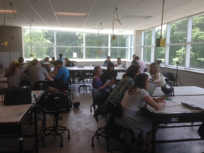
Time for each of the seven competing teams to meet and work on their proposals in the upstairs classroom of the Environment 3 Building at the University of Waterloo during Geothink’s Summer Institute.
By Drew Bush
Day two of Geothink’s Summer Institute began with a deeper dive into crowdsourcing led by Robert Goodspeed, assistant professor of Urban Planning at the University of Michigan’s Taubman College of Architecture and Urban Planning. In the morning, he presented hot topics in his own research including crowdfunding, formal crowdsourcing and the crisis-mapping tool Ushahidi.
“In my world, within a planning project or a collaborative effort, these sort of structured tools can be plugged in,” he told students of his work in developing a visual preference tool to engage the public in more formal participatory community planning processes. “Technology is forcing us to rethink our methodologies, and rethink how we think things work.”
Each day of the institute alternated morning lectures, panel discussions and in-depth case studies on topics in crowdsourcing with afternoon work sessions where professors worked with student groups one-on-one on their submission to the City of Ottawa on day three.
Not sure what constitutes crowdsourcing? The goal of the institute, run as part of a five-year Canadian Social Sciences and Humanities Research Council (SSHRC) partnership grant, was to provide undergraduate and graduate students from Geothink’s partners with knowledge and training in theoretical and practical aspects of crowdsourcing. See our post from day one to learn more about this important topic.
After some coffee, specific case studies brought home what crowdsourcing looks like in practice and the limitations of some crowd-sourced data due to demographic biases with gender amongst users who geo-reference data. Provided by Monica Stephens, assistant professor in the Department of Geography at State University of New York at Buffalo, and Daren Brabham,, assistant professor in the University of Southern California Annenberg School of Journalistm and Communication, these additional case studies gave insight into the types of research undertaken by Geothink researchers.
A random survey of users within many online mapping communities coupled with a look at interactions among members in specific communities proved revealing for Stephens.
“What became clear was that women were just as willing to socially tag, I was with so-and-so, but they weren’t willing to include the geographic information the way that men were,” Stephens told students in her case study on OpenStreetMap and other internet mapping communities. This simple fact, she demonstrated, has profound impacts on the types of features and attributes that get approved for inclusion on many maps.
Watch a clip of Stephens’s talk to find out how she conducted her research here:
For the students, the afternoon proved just as stimulating as all seven groups presented their initial concepts to the professors for feedback and guidance.
“I come from a GIS/Urban Planning background, and I found out about this through a professor,” said Alexa Hinves, a master’s student in Ryerson University’s Department of Geography who competed as a member of the group GeoPlay. “To me it’s just kind of incredible…you get to get together and do so many different activities. It’s not just you’re going to a conference and you’re listening to people for hours about what their interests are. But you are also sitting down and doing an intensive project and getting a lot of different perspectives.”
“You also get to think out of the box,” added her teammate, Ashley Zhang, a Ph.D. candidate at Waterloo University’s Department of Geography and Environmental Management.
Stay tuned for more iTunes podcasts from the Summer Institute here, check back on Geothink.ca for our last synopses of day three, and, of course, watch more of our video clips (which we’ll be uploading in coming days) here.
If you have thoughts or questions about this article or the video content, get in touch with Drew Bush, Geothink’s digital journalist, at drew.bush@mail.mcgill.ca.