Tag Archives: Geothink

Geothink Researcher Peter Johnson Honored with Early Researcher Award from the Government of Ontario

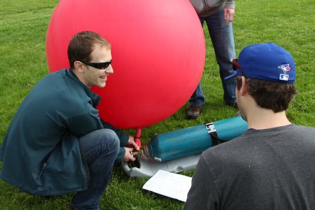
Peter Johnson undertakes the Public Lab of Open Technology and Science (PLOTS, or simply ‘Public Lab’) balloon mapping technique to test it for future use in a class.

Peter Johnson undertakes the Public Lab of Open Technology and Science (PLOTS, or simply ‘Public Lab’) balloon mapping technique to test it for future use in a class.

By Drew Bush

Peter Johnson, assistant professor of Geography and Environmental Management at the University of Waterloo, was honoured with the Ontario Government’s Early Researcher Award for his project, Measuring the Value and Impact of Open Data. Johnson was one of two professors in his department that were funded.
Peter Johnson, assistant professor in the University of Waterloo Department of Geography and Environmental Management, was recently awared Ontario's Young Researcher Award.

Peter Johnson, assistant professor in the University of Waterloo Department of Geography and Environmental Management, was recently awarded Ontario’s Early Researcher Award.

In the project, Johnson will build partnerships with stakeholders, develop case studies to measure the impact of open data initiatives, and assess how open data generates economic and social benefits. Ontario’s provincial and municipal governments now prioritize the sharing of open government data, like many North American communities.

And right now is a key time for evaluating the impacts of such data, Johnson told Geothink this past June at the University of Waterloo.

“I think we’ve reached a spot in open data provision where we understand the technical challenges to providing open data and some of the organizational challenges as well,” he said of his and his students’ work. “But it’s trying to understand what is the impact that open data provision is having. So trying to follow data from just being provided on a web site and a download portal to understanding are community groups using it, is the private sector using it, are other governments using it, or even is it being used internal to the government that’s providing it?”

Johnson’s research may impact how Ontario and other governments one day share open data and the way private developers, nonprofits, and citizens build applications and businesses using such data.

Other areas of research for Johnson and his students include looking at the use of government 311 applications that help citizens report overflowing garbage cans in a local park or if a particular sidewalk might need to be shoveled. Their research questions why governments are developing these applications and using them, the type of data such applications gather, and how this data can be used to improve government processes.

“Is this an opportunity for citizens to express their opinions on different potential developments or to connect with their elected officials?” he asked. “And how does this official channel compare to something that’s unofficial like Twitter?”

“What I’m really interested in is looking at is balancing citizen input that is delivered in these different ways,” he added. “So which one gets the results? Tweeting at your counselor or using the official government branded app to report your pothole at the end of your street?”

In addition to this research, Johnson published a paper with Geothink Head Renee Sieber, associate professor in McGill’s Deptartment of Geography and School of Environment,  this past July in Government Information Quarterly entitled “Civic open data at a crossroads: Dominant models and current challenges.

On his personal Web site, he writes that in this piece, “We take a look at the dominant models of open data provision by government and start to lay out what the challenges are for delivering open data. We tried to make this both a reflective look at where open data is, and also to push civic open data forward, examining how open data works as part of open government strategies.” Find a pre-print copy available here and also find the abstract below.

The award, given to 822 early career researchers since 2005, was given by the Ontario Ministry of Research and Innovation and The Ontario Research Fund – Small Infrastructure programs. The province will spend $209 million this year to support research projects and talent at research institutions across the province. This year’s successful 280 successful projects were chosen based on their research excellence and their economic and societal benefits for Ontario.

If you have thoughts or questions about this article, get in touch with Drew Bush, Geothink’s digital journalist, at drew.bush@mail.mcgill.ca.

Abstract
Civic open data at a crossroads: Dominant models and current challenges.
As open data becomes more widely provided by government, it is important to ask questions about the future possibilities and forms that government open data may take. We present four models of open data as they relate to changing relations between citizens and government. These models include; a status quo ‘data over the wall’ form of government data publishing, a form of ‘code exchange’, with government acting as an open data activist, open data as a civic issue tracker, and participatory open data. These models represent multiple end points that can be currently viewed from the unfolding landscape of government open data. We position open data at a crossroads, with significant concerns of the conflicting motivations driving open data, the shifting role of government as a service provider, and the fragile nature of open data within the government space. We emphasize that the future of open data will be driven by the negotiation of the ethical-economic tension that exists between provisioning governments, citizens, and private sector data users.

Geothoughts Talks 1, 2, & 3: Three Talks to Remember from the 2015 Geothink Summer Institute

Our first three Geothoughts Talks come from the 2015 Summer Institute.

Our first three Geothoughts Talks come from the 2015 Summer Institute.

By Drew Bush

Geothink’s Summer Institute may have concluded over a month ago, but, for those of you who missed it, we bring you three talks to remember. Run as part of Geothink’s five-year Canadian Social Sciences and Humanities Research Council (SSHRC) partnership grant, the Institute aimed to provide undergraduate and graduate students from the partnership and beyond with knowledge and training in theoretical and practical aspects of crowdsourcing.

Each day of the institute alternated morning lectures, panel discussions and in-depth case studies on topics in crowdsourcing with afternoon work sessions where professors worked with student groups one-on-one on their proposal to meet a challenge posed by the City of Ottawa. See our first post on this here.

The lectures featured Geothink Head Renee Sieber, associate professor in McGill University’s Department of Geography and School of Environment; Robert Goodspeed, assistant professor of Urban Planning at the University of Michigan’s Taubman College of Architecture and Urban Planning; Daren Brabham, assistant professor in the University of Southern California Annenberg School of Journalistm and Communication; and Monica Stephens, assistant professor in the Department of Geography at State University of New York at Buffalo.

Below we present you with a rare opportunity to learn about crowdsourcing with our experts as they discuss important ideas and case studies. A short summary describes what each talk covers.


Geothoughts Talk One: In-Depth Case Studies in Crowdsourcing (1hr 3min)

Join Sieber and Brabham as they discuss two case studies that examine the actual application of crowdsourcing technologies and techniques to real-world situations. First Sieber describes the work of her Master’s Student Ana Brandusescu in applying crowdsourcing technologies to chronic community development issues in three places in Montreal, QC and Vancouver, BC. Next, Brabham discusses one of his first efforts to research the application of crowdsourcing technology to public transportation planning during a design contest he held for a bus stop at the University of Utah campus in Salt Lake City, UT.


Geothoughts Talk Two: A Deeper Dive into Crowdsourcing: Advanced Topics in Crowdsourcing and Civic Crowdfunding (1hr 8min)

Goodspeed spends the morning covering three topics of inherent interest to anyone involved in crowdsourcing work. During this talk, he focuses in on three areas new to his own research including crowdfunding, formal crowdsourcing and the tool Ushahidi. Each of these topics helps prepare listeners for being a crowdsourcing professional.


Geothoughts Talk Three: Discussion on the Future of Crowdsourcing in the Public Sector (35 min)

Brabham and Goodspeed lead a discussion on where the future for crowdsourcing lies in the public sector. In particular, Goodspeed begins with an opening statement on how crowdsourcing can be used to help government agencies gain legitimacy by actually seeking input which can guide their actions. Brabham then challenges students to consider that crowdsourcing applications do fail and, even when they succeed, often can challenge whole professions that exist to collect the same data by other means.

If you have thoughts or questions about these podcasts, get in touch with Drew Bush, Geothink’s digital journalist, at drew.bush@mail.mcgill.ca.

City of Ottawa Selects Winner Out of Seven Student Designed Crowdsourcing Applications – Geothink Summer Institute Day 3

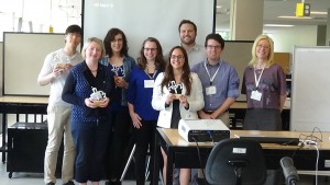
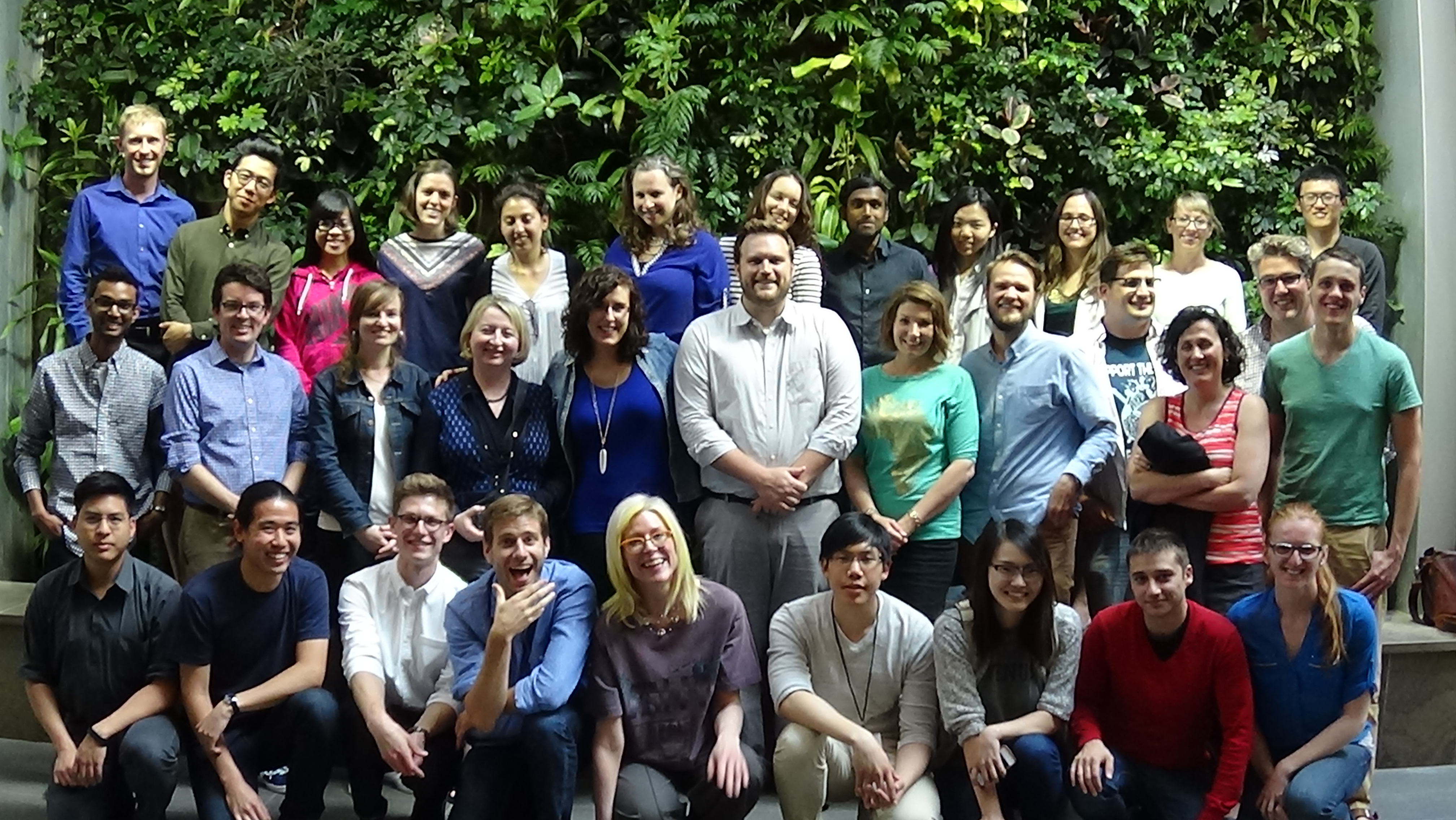
2015 Geothink Summer Institute students, faculty and staff after the conference concludes.

2015 Geothink Summer Institute students, faculty and staff after the conference concludes.

By Drew Bush

On day three the big issues discussed included using crowdsourcing in governance and the idea’s future in the public sector. By the end of the day, one of our student groups, GeoOne, had been crowned the winner by City of Ottawa officials and each of its members presented with a trophy in the image of Geothink’s logo, printed by a three-dimensional printer.

The winners, GeoOne, being presented their trophies by the Summer Institute's faculty.

The winners, GeoOne, being presented their trophies by the Summer Institute’s faculty.

But first, Daren Brabham, assistant professor in the University of Southern California Annenberg School of Journalistm and Communication, offered the students caution.

In a morning discussion, he reminded students not all crowdsourcing endeavours have been successes, and that flaws in some crowdsourced data mean it has limitations, as was pointed out on day two. Furthermore, one must consider traditional forms of data collection in comparison to crowdsourcing, he said, because whole institutions and professions exist to support such data collection’s objectivity.

For Brabham, however, this doesn’t mean crowdsourced data should be discredited. In fact, many aspects of the technology ensure it’s a very democratic way of making decisions and collecting data.

“It is easy to point to reasons why we shouldn’t be doing something, when you are in an established position of power and when you have a profession that you have built,” he said. “And I think this gets to maybe a more controversial point, and that’s—I see professionalism and the professions as really just ways to hold onto power.”

Check out more on Brabham’s views of the democratizing impact of crowdsourced data in the clip below:

The rest of the day leading up to the presentations was given over for students to fine-tune their pitches for the City of Ottawa and finalize their presentations themselves. Seven groups competed: GeoOne, GeoPlay, GeoWild, Grads Gone Ottawild, Ministry of Municipal Engagement, Terra Solutions and Wild VASS.

The excitement in the room before the first presenters began was palpable. This may have stemmed, in part, from the realization that the City of Ottawa and its citizens needed actual help rather than this being just some academic exercise. For some students, this meant the stakes were higher.

“It’s good that it’s rooted in something real,” Victoria Fast, a Ph.D. Candidate at Ryerson University in the Department of Environmental Applied Science and Management, said. “And I think that makes it more motivating to come up with something as good as possible because if they implement it, it improves how people are finding natural resources in their community and it can make things better for everybody.”

Each of the group’s proposals were designed to be used on mobile devices, a Web site, and often a combination of both. Many groups used maps to help citizens geo-locate themselves in relation to the city’s parks. However, how users were asked to contribute and in what forms varied greatly from one group’s app where users would vote on badges for particular uses at each park to another’s creation of ‘mad-lib’ story forms where users filled in the word for each park visit. Check out each of the student groups’ final presentations here:

GeoOne (Winner)

GeoPlay

GeoWild

Grads Gone Ottawild

Ministry of Municipal Engagement

Terra Solutions

Wild Vass

Stay tuned for more iTunes podcasts from the Summer Institute here, and, of course, watch more of our video clips (which we’ll be uploading in coming days) here.

If you have thoughts or questions about this article or the video content, get in touch with Drew Bush, Geothink’s digital journalist, at drew.bush@mail.mcgill.ca.

A Deeper Dive into Crowdsourcing – Geothink Summer Institute Day 2

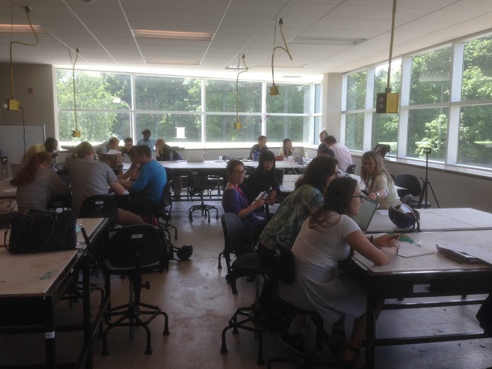
Time for each of the seven competing teams to meet and work on their proposals in the upstairs classroom of the Environment 3 Building at the University of Waterloo during Geothink's Summer Institute.

Time for each of the seven competing teams to meet and work on their proposals in the upstairs classroom of the Environment 3 Building at the University of Waterloo during Geothink’s Summer Institute.

By Drew Bush

Day two of Geothink’s Summer Institute began with a deeper dive into crowdsourcing led by Robert Goodspeed, assistant professor of Urban Planning at the University of Michigan’s Taubman College of Architecture and Urban Planning. In the morning, he presented hot topics in his own research including crowdfunding, formal crowdsourcing and the crisis-mapping tool Ushahidi.

“In my world, within a planning project or a collaborative effort, these sort of structured tools can be plugged in,” he told students of his work in developing a visual preference tool to engage the public in more formal participatory community planning processes. “Technology is forcing us to rethink our methodologies, and rethink how we think things work.”

Each day of the institute alternated morning lectures, panel discussions and in-depth case studies on topics in crowdsourcing with afternoon work sessions where professors worked with student groups one-on-one on their submission to the City of Ottawa on day three.

Not sure what constitutes crowdsourcing? The goal of the institute, run as part of a five-year Canadian Social Sciences and Humanities Research Council (SSHRC) partnership grant, was to provide undergraduate and graduate students from Geothink’s partners with knowledge and training in theoretical and practical aspects of crowdsourcing. See our post from day one to learn more about this important topic.

After some coffee, specific case studies brought home what crowdsourcing looks like in practice and the limitations of some crowd-sourced data due to demographic biases with gender amongst users who geo-reference data. Provided by Monica Stephens, assistant professor in the Department of Geography at State University of New York at Buffalo, and Daren Brabham,, assistant professor in the University of Southern California Annenberg School of Journalistm and Communication, these additional case studies gave insight into the types of research undertaken by Geothink researchers.

A random survey of users within many online mapping communities coupled with a look at interactions among members in specific communities proved revealing for Stephens.

“What became clear was that women were just as willing to socially tag, I was with so-and-so, but they weren’t willing to include the geographic information the way that men were,” Stephens told students in her case study on OpenStreetMap and other internet mapping communities. This simple fact, she demonstrated, has profound impacts on the types of features and attributes that get approved for inclusion on many maps.

Watch a clip of Stephens’s talk to find out how she conducted her research here:

For the students, the afternoon proved just as stimulating as all seven groups presented their initial concepts to the professors for feedback and guidance.

“I come from a GIS/Urban Planning background, and I found out about this through a professor,” said Alexa Hinves, a master’s student in Ryerson University’s Department of Geography who competed as a member of the group GeoPlay. “To me it’s just kind of incredible…you get to get together and do so many different activities. It’s not just you’re going to a conference and you’re listening to people for hours about what their interests are. But you are also sitting down and doing an intensive project and getting a lot of different perspectives.”

“You also get to think out of the box,” added her teammate, Ashley Zhang, a Ph.D. candidate at Waterloo University’s Department of Geography and Environmental Management.

Stay tuned for more iTunes podcasts from the Summer Institute here, check back on Geothink.ca for our last synopses of day three, and, of course, watch more of our video clips (which we’ll be uploading in coming days) here.

If you have thoughts or questions about this article or the video content, get in touch with Drew Bush, Geothink’s digital journalist, at drew.bush@mail.mcgill.ca.

Laying Out the Challenge – Geothink Summer Institute Day 1

The main atrium of the Environment 3 Building at the University of Waterloo between sessions at Geothink's Summer Institute.

The main atrium of the Environment 3 Building at the University of Waterloo between sessions at Geothink’s Summer Institute.

By Drew Bush

The day began with a warm welcome from Geothink Head Renee Sieber, associate professor in McGill University’s Department of Geography and School of Environment. By afternoon, the City of Ottawa had presented the 29 students attending Geothink’s Summer Institute at the University of Waterloo in Ontario, Canada with the challenge of engaging its citizens with city natural areas.

Each day of the institute alternated morning lectures, panel discussions and in-depth case studies on topics in crowdsourcing with afternoon work sessions where professors worked with student groups one-on-one on their proposed solution to the City of Ottawa’s challenge. As the institute progressed, more time was given to the seven student groups to work on their solutions and prepare a final pitch to the city on day three.

The morning lecture topics ranged from “Conceptual Foundations in Crowdsourcing” to “The Future of Crowdsourcing in the Public Sector” and were taught or co-taught by Sieber, Robert Goodspeed, assistant professor of Urban Planning at the University of Michigan’s Taubman College of Architecture and Urban Planning; Daren Brabham, assistant professor in the University of Southern California Annenberg School of Journalistm and Communication; and Monica Stephens, assistant professor in the Department of Geography at State University of New York at Buffalo.

Not sure what constitutes crowdsourcing? The goal of the institute, run as part of a five-year Canadian Social Sciences and Humanities Research Council (SSHRC) partnership grant, was to provide undergraduate and graduate students from Geothink’s partners with knowledge and training in theoretical and practical aspects of crowdsourcing. And that’s a topic Brabham has been studying, as he puts it modestly, for “several years.”

“And I’ve been trying to look at how to take this model, which I define as connecting organizations with online communities to mutually solve problems or produce goods,” he told Geothink. “Taking that model which as been used in business and a number of for profit endeavours and trying to translate it for governments, for non-profits, for public health.”

On Day 1, students at Geothink’s Summer Institute worked together to solve Ottawa’s crowdsourcing problem using the knowledge gained in earlier sessions as well as individual areas of expertise. Much like many real-world challenges that crowdsourcing has been used to address, the presentation from the City of Ottawa made clear that the problem the city faced was complex and multifaceted. Goodspeed helped to summarize some elements of what was expected of students.

“What a wonderful, rich context, I mean, who knows what the problem is?” he told students. “Is it that people are going to too many parks or the wrong parks, or which people are we talking about? We have no idea…And I think this is very typical for a lot of problem settings you’ll encounter. And, in that sense, almost any month they showed could have been itself a crowdsourcing application.”

Watch a clip of Goodspeed’s introduction here:

After they’d been given a chance to start discussing ideas for crowdsourcing applications in their groups, Sieber and Stephens helped students to begin thinking about the geographical aspects of the applications they were designing as well as technical limitations they might face.

“So, this is a summer institute on crowdsourcing, why do we even talk about geography?” Sieber told students later in the first day.  “Because most open data, most data that comes out of government has some geographic component in it somewhere. So it’s useful often to tie crowdsourcing to geography.”

“If nothing else, that implies there is a jurisdictional aspect to the way that people communicate with government, that is that people are bounded in place,” she added.

Stay tuned for more iTunes podcasts from the Summer Institute here, check back on Geothink for synopses of days two and three, and, of course, watch more of our video clips (which we’ll be uploading in coming days) here.

Watch a clip of the presentation the City of Ottawa gave our students here (Beware, for the technophobic, it was conducted over videoconference).

If you have thoughts or questions about this article or the video content, get in touch with Drew Bush, Geothink’s digital journalist, at drew.bush@mail.mcgill.ca.

Part 1: Why Geothink? We ask Geothink’s Head about the Partnership’s Vision and Goal

By Drew Bush

Renee Sieber, associate professor in McGill University’s Department of Geography and School of Environment.

Part 1 (of 2). This is the first in a two part series with the head of Geothink.ca, Renee Sieber, an associate professor in the Department of Geography and School of Environment at McGill University. In this first part, we talk with Sieber about Geothink itself; its vision, goal and design. In our next installment, we’ll pick up the story of how she sees civic participation in North America during an age of technological change.

Now in the second year of a five-year partnership research grant funded by the Canadian Government’s Social Sciences and Humanities Research Council, Geothink.ca involves 26 researchers and 30 partners in examining the implications of increasing two-way exchanges of locational information between citizens and governments. Yet the vision for this type of collaborative, cross-disciplinary project began years before.

Geothink sprang from an idea that we’re in this period of huge technological change when it comes to our ability to communicate with cities as citizens, and cities’ ability to communicate with citizens,” Renee Sieber, the project’s head and an associate professor at McGill University, said. “So we have Yelp and Yelp allows us to communicate about restaurants and accommodations in cities. We have FourSquare which allows us to socially check-in and temporarily become mayors of places in cities.”

“It’s a very different world in which we can on a Saturday evening or an early Monday morning know what’s happening in our cities and comment on what’s happening in cities,” she added. “It’s technologies like sensors in road networks that allow cities to know how we’re travelling through a town, where we are meeting up with people to, for example, create dynamic neighbourhoods of where people congregate and want to see their friends to then create better urban design for cities. So the technology is really transforming the way we can have this interaction.”

It’s these types of technology-transformed interactions that Sieber and Geothink’s researchers will chart and begin to examine the implications of. In part, that’s because not all applications of new digital technologies have positive connotations. For example, these technologies make it easier for cities to conduct better surveillance of citizens since they can track people through the cell-phones they carry or by the places they check into.

Such privacy concerns have the potential to make people very uncomfortable, particularly because it means placing more trust in governments and technologies that could misuse or abuse this data. Other problems include the mistaken belief that new technologies mean more people can access and interact with their cities. While efforts to take some conversations or debates online might be advantageous to certain populations, it can also be disenfranchising to others, according to Sieber.

“Democracy can be very, very messy, and sometimes you need to get people who don’t necessarily agree with each other in the same room with each other,” Sieber said. “You can not necessarily rely totally on harvesting, for example, Tweets or Facebook posts to understand public sentiment. Democracy and perceptions about what a city should do are often much more textured than that.”

And that’s exactly why Geothink incorporates perspectives from different disciplines within academia including geography, law, communications, urban planning and computer science. For Sieber, the overall goal is to get a better handle on the diverse set of interactions that technology has made possible between cities and their citizens.

“But we also need to reach beyond the academy to businesses, to lots and lots of cities and representatives of cities about how they experience these changes in real-time, what technologies do they use, and how it has shifted their conversations with citizens,” Sieber said. “So what are they seeing on the ground? How are they engaging citizens via media-like hackathons, for example, where they’re bringing in coders? Are they seeing the same sorts of people, or do they think that participation is being extended and broadened, or does it seem to be just as narrow as it was before?”

If you have thoughts or questions about this article, get in touch with Drew Bush, Geothink’s digital journalist, at drew.bush@mail.mcgill.ca.

Geothoughts 1: What’s in a Plan? Innovation at the Cost of Democracy in Canada

Screen Shot 2016-02-24 at 8.30.05 PM

Our first podcast delves deeper into how Canada’s Action Plan for Open Government 2.0 has failed to fully engage civil society groups.

By Drew Bush

We’re very excited to present you with our first Geothink.ca Podcast in our series, Geothoughts. You can also subscribe to this Podcast by finding it on iTunes.

Our first podcast delves deeper into the opinions of Tracey Lauriault, a researcher at The Programmable City project who specializes in open data and open government in Canada. We explore how Canada’s Action Plan for Open Government 2.0 has failed to fully engage civil society groups and take you inside her work with front-line groups like the Canadian Council on Social Development and the Federation of Canadian Municipalities.

Thanks for tuning in. And we hope you subscribe with us at Geothoughts on iTunes. A transcript of this original audio podcast follows.

TRANSCRIPT OF AUDIO PODCAST

Last week Geothink.ca brought you a story about the lack of civil society engagement with Canada’s Action Plan for Open Government 2.0. This week we delve deeper to find out what exactly is missing.

[Geothink.ca theme music]

Welcome to Geothoughts. I’m Drew Bush.

“For me that’s the disappointment. There wasn’t outreach to civil society as I know it. And that’s the civil society organizations that are actually involved in policy formulation or evidence-informed policy on whatever—a variety of issues from transportation planning to anti-poverty to mining extraction.”

That’s the opinion of a researcher at The Programmable City project who specializes in open data and open government in Canada.

“So my name is Tracey Lauriault and I’m working on a European Research Council funded project called The Programmable City. It’s based here at the National University of Ireland in the village of Maynooth at the National Institute for Regional and Spatial Analysis.”

Lauriault believes that Canada’s government is failing to meet the promise held out by new technology and open data. That’s because it’s falling way behind in actually engaging citizens in public policy debates even as it closes institutions such as Canada’s census, scientific organizations or civil society groups that produce this data. In essence, the government’s plan has gotten really good at creating more efficient e-government services but, for Lauriault, this is a very limited view of what open government and open data should be.

As an indication of this failure, Lauriault asks a simple question. Each year the Federation of Canadian Municipalities undertakes a quality of life indicator system that measures a number of factors including the environment, economy, sustainability, poverty and accessibility. Working with approximately 110 indicators and 200 variables, the organization surveys more than 40 different government organizations, including 24 cities across Canada.

“Can we go to that federal portal and could we construct that indicator system with the data in that portal? No. We’re still at the making cold calls, trying to find that public official who knows something about, you know, personal bankruptcies or whatever dataset that we’re looking at on the federal level—an expert at citizen immigration— and so on to collect those data, every year, to construct that indicator system.”

She points out that there are a number of civil society organizations which already do quite good work with data—often data they’ve had to collect and create an infrastructure for themselves. For example, the Canadian Council on Social Development’s Community Data Program has undertaken capacity building, held workshops, made community maps, created newsletters and worked with data all in collaboration with local groups like fire and police departments, anti-poverty organizations, school boards and ethnic groups.

“They’ve been doing that kind of data literacy piece on the front lines, but they’re not called open data. They’re just doing this for evidence-informed policy. So I think it’s not just the fault I think of the Treasury Board secretariat of Canada. I think that there is this kind of epistemic disconnect between, you know, civil society that works with data on an ongoing basis to inform policy and those who make apps.”

And it’s this dichotomy, Lauriault believes, that’s at the heart of why Canada’s Action Plan for Open Government 2.0 is failing to engage citizens and groups interested in policy.

“If the strategy is going to be innovation and economic return then we’re going to stay with app developers. That’s what’s going to stay as an open data planned strategy and outreach plan. If we think it’s about democratic deliberation and evidence-informed policy and real public engagement, then the strategy has to be different and how the open government plan and open data plan are evaluated also has to differ and change.”

[Geothink.ca theme music]

[Voice over: Geothoughts are brought to you by Geothink.ca and generous funding from Canada’s Social Sciences and Humanities Research Council.]

###

If you have thoughts or questions about this podcast, get in touch with Drew Bush, Geothink’s digital journalist, at drew.bush@mail.mcgill.ca.

Geothink Program Guide for the Associaton of American Geographers (AAG) 2015 Annual Meeting

This year's American Association of Geographer's (AAG) Annual Meeting is in Chicago, Illinois.

This year’s American Association of Geographer’s (AAG) Annual Meeting is in Chicago, Illinois (Photo courtesy of AAG.org).

By Drew Bush

A long line-up of Geothinkers will be presenting at this year’s Association of American Geographers (AAG) Annual Meeting in Chicago next week. You’ll definitely not want to miss four of our team members as panelists on Civic technology: governance, equity and inclusion considerations on Thursday at 8:00 AM. Other highlights include presentations by Geothink Principal Investigator Renee Sieber and our students including Cheryl Power and Tenille Brown.

Below we’ve compiled the schedule for all of the project’s team members, collaborators and students who will be presenters, panelists and chairs during the conference. Find a PDF of our guide here. We hope you find this useful for finding the right sessions to join. You can also find the full preliminary AAG program here.

If you’re not able to make the conference, you can follow along on Twitter and use our list of Twitter handles below to join the conversation with our participants.

Join the Conversation on Twitter
Alex Aylett: @openalex_                                    Peter Johnson: @peterajohnson
Zorica Nedovic-Budic: @TurasCities               Andrea Minano: @Andrea_Minano
Tenille Brown: @TenilleEBrown                       Claus Rinner: @ClausRinner
Jonathan Corbett: @joncorbett                       Pamela Robinson: @pjrplan
Sarah Elwood: @SarahElwood1                       Teresa Scassa: @teresascassa
Victoria Fast: @VVFast                                       Renee Sieber: @RE_Sieber
Muki Haklay: @mhaklay                                    Harrison Smith: @Ambiveillance

And remember to use the conference hashtag #AAG2015 and our hashtag #Geothink or address @geothinkca when you Tweet.

Come to our Sessions at AAG 2015

Tuesday, April 21

Wednesday, April 22

Thursday, April 23

Friday, April 24

Saturday, April 25

If you have thoughts or questions about this article, get in touch with Drew Bush, Geothink’s digital journalist, at drew.bush@mail.mcgill.ca.