Tag Archives: forestry

Open Data and Urban Forests – What’s Next?


This is a guest post from Geothink Post Doctoral researcher James Steenberg, Ryerson University School of Urban and Regional Planning, working with Dr. Pamela Robinson.


By James Steenberg, PhD

I recently had the opportunity to go on a Geothink summer exchange at the University of Waterloo hosted by Dr. Peter Johnson, a Geothink co-applicant and Assistant Professor at Waterloo’s Department of Geography and Environmental Management. The main goal of the exchange was to learn about open data and open government from Dr. Johnson with the ultimate goal of writing a collaborative paper on the potential role of open data in municipal urban forestry.

I wrote about my experiences during the exchange in a previous post, and subsequently left Waterloo with an open question on open data – can the open data/open government movement also be embraced in urban forestry? I would like to justify this question with two contrasting tales of cities.

Toronto

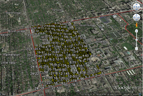
The first tale is about Toronto, more specifically about a neighbourhood in Toronto called Harbord Village where I conducted some of my PhD field research. The neighbourhood and its residents association are quite active in the stewardship of their urban forest. They even undertook a citizen science initiative to inventory and assess all 4,000 of their trees. I re-measured some of their tree inventory in 2014 with the purpose of identifying social and ecological drivers of urban forest vulnerability (e.g., tree mortality). Soon after, my current Geothink supervisor Dr. Pamela Robinson and I began to speculate that a key agent of change was housing renovation. Where we noted incidences of tree mortality, there were often shiny new home additions or driveways where once a tree stood. Fortunately, the City of Toronto’s open data portal includes building permit data and we were able to test this theory. We did indeed find that building permits (i.e., housing renovation) significantly predicted higher rates of tree mortality.

Municipal urban forestry departments are responsible for planting, maintaining, and removing trees on public land, as well as protecting and sustaining the urban forest resource on public and private land through various policies and regulations. However, it’s important to note that urban forestry is plagued by management challenges due to the limited space and harsh growing conditions of cities. Simply put, trees frequently die when they’re not supposed to – often for unknown reasons – and practitioners are continuously seeking out ways to reduce unnecessary tree mortality. Our findings suggest that urban foresters aren’t talking to urban planners when they should be, or vice versa. Urban planners collect data describing where building renovation occurs. Urban foresters collect data describing where city trees are dying and being removed. Blending these datasets has revealed that better coordination and horizontal data sharing across branches of government might help keep public trees alive. More broadly, these findings indicate an inefficiency in municipal service provision – the provision of the beneficial ecosystem services that public trees provide to city residents. What other urban forest inefficiencies might open data reveal?
geothink_harbord_village
The Harbord Village tree inventory and corresponding volunteered geographic information (VGI)

Edmonton

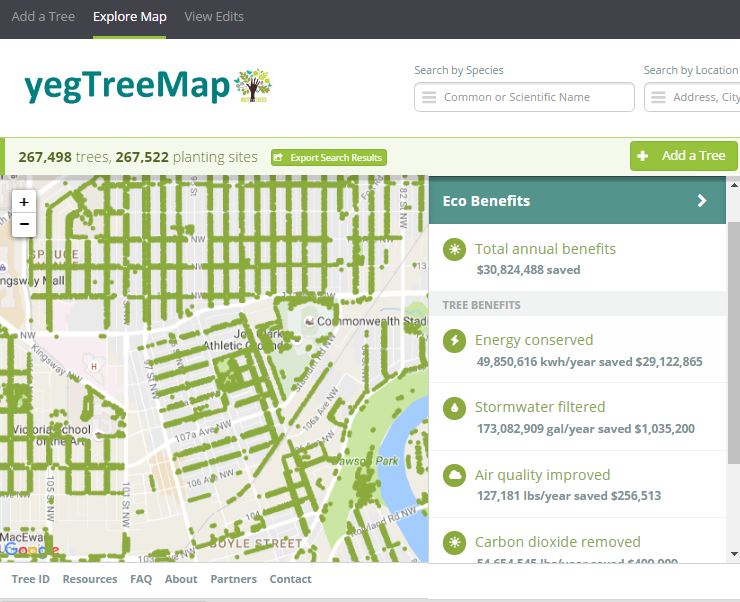
The second tale is about Edmonton and paints a different picture. I stumbled across one of Edmonton’s approaches to urban forestry during my summer exchange while learning about the various open data programs across Canada. Their urban forestry branch has used Open Tree Map – a web-based application for participatory tree mapping – in their yegTreeMap project so that “individuals, community groups, and government can collaboratively create an accurate and informative inventory of the trees in their communities”. In short, citizens in Edmonton that feel the urge to participate in municipal urban forestry can do so by downloading tree inventory data, using the data to their heart’s content (e.g., community-based stewardship programs), and entering new data into the City’s database.

This approach to what I’ve started calling ‘open urban forestry’ could conceivably improve citizen engagement with municipal government and its urban forestry programs. Much of the urban forest resource is situated on private residential property that the city doesn’t have direct access to, so citizen engagement in stewardship activities is a key piece of the puzzle. Moreover, urban tree inventories are notoriously fickle when it comes to data, being both expensive to generate and quick to become out-of-date and obsolete. Crowdsourcing a city’s tree inventory could conceivably provide better data to support decision-making in urban forestry, such as where to plant trees, what species to plant, and where trees are in decline or hazardous.
geothink_edmonton
Edmonton’s yegTreeMap user interface on Open Tree Map

I have been very fortunate to be able to incubate these ideas with guidance from Dr. Robinson and her knowledge of urban planning and citizen engagement. Moreover, it was because of my Geothink summer exchange with Dr. Johnson at the University of Waterloo and his knowledge of open data and open government that I arrived at my current line of thinking on the benefits of open data and crowdsourcing for urban forestry. My next steps forward will be to think critically about these ideas as well. What are the environmental justice implications around who gets to participate in open urban forestry? Crowdsourcing tree inventories through open data programs may provide better data, but do they simultaneously justify the under-funding of municipal urban forestry programs? I’m excited to develop these collaborative ideas over the coming weeks and to hopefully answer my open question on open data.

My sincere thanks to Geothink for giving me the opportunity to go on a summer exchange at the University of Waterloo. Thank you Dr. Peter Johnson for hosting me at the Department of Geography and Environmental Management and for introducing me to your students and colleagues.

To the Geothink community members: please don’t hesitate to contact me if you have further questions or if you are considering going on a summer exchange yourself.

James Steenberg is a postdoctoral researcher under the supervision of Dr. Pamela Robinson at Ryerson University’s School of Urban and Regional Planning. His research focuses on the ecology and management of the urban forest. James can be reached by email – james.steenberg@ryerson.ca – and on Twitter – @JamesSteenberg

Paper Spotlight: Examining Urban Reasoning Skills in the Age of Digital Cities

Smart citizens

Smart citizens of the future must develop the skillsets required to understand spatio-temporal interactions in dynamically linked urban networks of places according to Geothink Co-Applicant Stéphane Roche (Photo courtesy of http://www.i2cat.net/sites/default/files/smart-city.jpg).

By Drew Bush

In a paper published this past May, Geothink Co-Applicant Stéphane Roche posits that emerging smart cities require citizens to develop an urban intelligence that meshes material realities with digital information. In order to fully manage and engage with urban spaces, future smart citizens must develop the skillset required to understand spatio-temporal interactions in dynamically linked urban networks of places.

Stéphane Roche is a professor and vice dean of research for the Faculty of Forestry, Geography, and Geomatics at the University of Laval (Photo courtesy of www.scg.ulaval.ca).

Entitled Geographic information science III: Spatial thinking, interfaces and algorithmic urban places-Toward smart cities, the paper was published in Progress in Human Geography. Roche, a professor and vice dean of research for the Faculty of Forestry, Geography, and Geomatics at the University of Laval, has previously written two papers on the subject. The series of papers defines urban intelligence, the importance of spatial reasoning in smart cities, and the organization of digitally enabled cities.

“Most of the resources that are today available in order to help people to move in the city, are available—are digitally available,” Roche said. “[Yet] at the same time, mobility in the city is really grounded in the materiality. If you need to walk or if you need to take your bike, it’s an active kind of mobility. And if you don’t really know perfectly the places where you need to travel, you need to have the minimum capability to access information from different kinds of interfaces. Through your phone, through the Internet, through a different kind of display available in the city for example.”

Transportation presents but one case study for examining the integration of digital technology into physical urban places. Roche expands on this interaction to further define place as consisting of three elements: 1) A geographical location; 2) An event (such as an accident, festival, or meeting); and 3) A name. This, of course, means that two separate places could involve the same physical space but at different times.

As you may imagine, this type of insight takes time to develop. After reflecting on the existing literature in the field, along with his own previous work, Roche begins his first paper, Geographic Information Science I: Why does a smart city need to be spatially enabled? by emphasizing the importance of Geographic Information Science (GIS) to smart cities. He argues that the smart city is first and foremost a spatially enabled city.

His second paper, Geographic information science II: Less space, more places in smart cities, Roche advances the idea that modern cities consist of networks of connecting places, amends the very definition of place, and posits urban intelligence as the capability to understand how urban places are created and how they interact. Finally, his most recent third paper comes full circle to question why people who have developed urban intelligence necessarily also employ spatial learning and reasoning skills.

“Actually, what I’ve tried to do in this report is probably link what I define as the urban intelligence,” he said. “That means the capability of someone, people, or a group to understand the urban dynamic by using spatial skills and spatial thinking abilities. That means making the link between different components of the urban environment. So this is what I define as the urban intelligence. The capability of understanding what’s happened at the specific time and specific place.”

“The aim, ok, is to say in our current modern environment, there are multiple opportunities and tools and approaches that could help humans to improve their spatial thinking ability,” he added. “And these improvements will be more and more required if people want to engage. That means they will, there is no way to keep them engaged without spatial thinking abilities in this kind of new urban environment where everything is connected. Where everything is based on dynamic fluxes and mobilities. So if you are not able to understand how those dynamics work, you will have more and more difficulty in getting grounded in the place where you live.”

Please find links and abstracts to each paper mentioned in this article below:

Abstract 1
Geographic Information Science I: Why does a smart city need to be spatially enabled?
In this report I propose to examine the concept of the ‘smart city’ from the standpoint of spatial enablement. I analyse emerging research on smart cities, particularly those addressing the potential role of GISciences in the development and implementation of the concept of smart cities. I develop the idea that the intelligence of a city should be measured by its ability to produce favourable conditions to get urban operators (citizens, organizations, private companies, etc.) actively involved into sociospatial innovation dynamics. To obtain such a commitment, I believe that operators should be able to develop and mobilize (digital) spatial skills so that they could efficiently manage their spatiality. In other words, I argue that a smart city is first of all a spatially enabled city.

Abstract 2
Geographic information science II: Less space, more places in smart cities
This second report is dedicated to the concept of ‘place’ revisited in the context of smart cities. Some recent studies suggest that today’s digital cities rely more on an approach to the urban context based on a network of connected places than on an approach to the city built on areal spaces. Does it mean that there are more places and fewer spaces in spatially enabled cities? Is the intelligence of a city mainly related to its ability to sound out the genesis of urban places? These issues raise questions about the design of spatial models used to build GIS, as well as place-based urban design methods and tools. This second report explores these questions from the standpoint of GISciences.

Abstract 3
Geographic information science III: Spatial thinking, interfaces and algorithmic urban places—Toward smart cities
This third report examines interfaces as a key element enabling spatial skills, and development of new forms of digital spatialities for smart cities. Digital technology is becoming consubstantial to urban materiality, but map interfaces are particularly central tools for indexing (geographic) knowledge and expertise, accessing informational components of digital cities, and actively engaging digital dimensions of urban places.

If you have thoughts or questions about the article, get in touch with Drew Bush, Geothink’s digital journalist, at drew.bush@mail.mcgill.ca.