Author Archives: Geothink

Torts of the Geoweb: (or the liability question) Part I

Screenshot

Mapping Ottawa’s open data on tobogganing hills (Photo courtesy of ottawastart.com)

By Tenille Brown, PhD student in the Faculty of Law at the University of Ottawa

Recently, on March 3rd as part of the continuing Geothink Project, I hosted a Twitter chat about tort liability with Mapping Mashups. This online forum was joined by Geothink partners and friends and the primary topic discussed was the role of tort law and how and where it fits in the context of the Geoweb, liability and moral responsibility. One active participant of this Twitter discussion was British academic Muki Haklay, a collaborator on the Geothink project more broadly, and Haklay later wrote up some highlights from this discussion, available here. I have been considering the role of tort liability in multiple contexts for some time now, both prior to the online discussion and subsequent to it. I have not been thinking of this idea so much in a typical “finding a problem” lawyerly way, but more in a “trying to understand the allocation of responsibility” kind of way. From the legal perspective, questions about how we should handle the mountains of data collected and produced by governments and citizens alike, jumps out at me. For these reasons I chose to place the focus of the Twitter chat on tort liability rather than the challenges of protecting the privacy of personal information, or copyright issues in geospatial information, which have been discussed elsewhere.

With the increase in platforms and data sources (both government and volunteered) on the geoweb, there is also an increase in opportunities for legal liability to attach to this information. With Canadian cities releasing data sets of all types of information, from proposed roadways to beach water sampling data, the liability question is not hypothetical, but of increasing importance. Of course, cities are carrying out their due-diligence by ensuring personal information does not get released, following the principles of the open government license. But still, some questions remain to be answered such as, what legal tools are in place to deal with third parties who take government information and use that information in a way that causes harm?

One example that immediately comes to mind is the use of open data to create apps for the reporting of pot-holes through cities 311 app, as happens in Toronto. A more apt example for Ottawa is the recently released information about hills open to tobogganing throughout the city, which was collated in a map here. Does liability attach to this information? If so, would information which highlights any hazards on the hill amount to a defence in a negligence action? How would we assign liability if citizenship were to take government data and create an open data app which contains outdated data?

In his write-up about the chat, I think Muki Haklay framed this problem correctly as an ethics problem. Haklay writes, Somehow, the growth of the geoweb took us backward. The degree to which awareness of ethics is internalised within a discourse of ‘move fast and break things‘, software / hardware development culture of perpetual beta, lack of duty of care, and a search for fast ‘exit’ (and therefore IBG-YBG) make me wonder about which mechanisms we need to put in place to ensure the reintroduction of strong ethical notions into the geoweb. As some of the responses to my question demonstrate, people will accept the changes in societal behaviour and view them as normal… In fact, tort liability principles recognize that if a wrong has been committed (sometimes even without intent), then the person who committed the harm might be required to compensate the individual. The very basis of tort law is that we ought to provide remedies for those wronged. Based on this aim, the courts don’t always uphold contracts of adhesion (which seek to limit liability).

The principles of tort liability understood as a matter of ethics and responsibility, provides opportunities for the prevention of harm and the accountability of government. This has long been recognized in the New York context, where the law stipulates that should a person trip on the sidewalk (or pothole), the city is only liable if it has been reported. To ensure reporting, every year the Big Apple Pothole and Sidewalk Corporationmaps out the cracks, holes and potholes throughout the city (and here). For its part, Toronto reports it has filled in almost 50,000 potholes in 2015 to date and over the past years there has been a 40% increase in drivers receiving compensation from pot-hole induced damage to cars. (The same report does not detail the number of complaints that have been made by the 311 reporting service).

The twitter conversation demonstrates that legal analysis questions, such as who has standing to bring a legal claim, who bears legal responsibility for information, and which courts have jurisdiction, are only the beginning of tort legal questions. A second analysis begs that we understand data in a larger framework which takes into account duties and responsibilities. Focusing on the prevention of harm, we could argue, that there should be a larger set of core activities or areas for which liability cannot be contracted out. These core areas presumably would pertain to the health, safety and well-being of citizenship, particularly that they be tailored to protect the interests of those who cannot be expected to know the details of tortious liability, nor necessarily how to navigate geoweb activities.

Tenille Brown is a PhD student in the Faculty of Law at the University of Ottawa and a Geothink student member. Her research is in the areas of legal geography, including property, spatial and citizen engagement, in the Ottawa context.

She can be reached on twitter, @TenilleEBrown and via email, Tenille.Brown@uottawa.ca.

Crosspost: Geoweb, crowdsourcing, liability and moral responsibility

This post is cross-posted with permission from Po Ve Sham – Muki Haklay’s personal blog. Muki is a Geothink collaborator at the University College London and the co-director of ExCiteS.

By Muki Haklay

Yesterday [March 3rd, 2015], Tenille Brown led a Twitter discussion as part of the Geothink consortium. Tenille opened with a question about liability and wrongful acts that can harm others

If you follow the discussion (search in Twitter for #geothink) you can see how it evolved and which issues were covered.

At one point, I have asked the question:

It is always intriguing and frustrating, at the same time, when a discussion on Twitter is taking its own life and many times move away from the context in which a topic was brought up originally. At the same time, this is the nature of the medium. Here are the answers that came up to this question:


You can see that the only legal expert around said that it’s a tough question, but of course, everyone else shared their (lay) view on the basis of moral judgement and their own worldview and not on legality, and that’s also valuable. The reason I brought the question was that during the discussion, we started exploring the duality in the digital technology area to ownership and responsibility – or rights and obligations. It seem that technology companies are very quick to emphasise ownership (expressed in strong intellectual property right arguments) without responsibility over the consequences of technology use (as expressed in EULAs and the general attitude towards the users). So the nub of the issue for me was about agency. Software does have agency on its own but that doesn’t mean that it absolved the human agents from responsibility over what it is doing (be it software developers or the companies).

In ethics discussions with engineering students, the cases of Ford Pinto or the Thiokol O-rings in the Discovery Shuttle disaster come up as useful examples to explore the responsibility of engineers towards their end users. Ethics exist for GIS – e.g. the code of ethics of URISA, or the material online about ethics for GIS professional and in Esri publication. Somehow, the growth of the geoweb took us backward. The degree to which awareness of ethics is internalised within a discourse of ‘move fast and break things‘, software / hardware development culture of perpetual beta, lack of duty of care, and a search for fast ‘exit’ (and therefore IBG-YBG) make me wonder about which mechanisms we need to put in place to ensure the reintroduction of strong ethical notions into the geoweb. As some of the responses to my question demonstrate, people will accept the changes in societal behaviour and view them as normal…

See the original post here. twitter

Tracey P. Lauriault on Citizen Engagement (or lack thereof) with Canada’s Action Plan on Open Government 2.0

tlauriault312

Tracey is a Postdoctoral Researcher in the new field of Critical Data Studies.

By Drew Bush

More than 1,450 individuals collectively generated 2,010 ideas, comments and questions for the Canadian Government on its Action Plan for Open Government 2.0. But one researcher with The Programmable City project who studies open data and open government in Canada feels these numbers miss the real story.

The process leading up to the “What We Heard” report, issued after the completion of consultations from April 24–October 20, 2014, only reflected the enthusiasm of the open data programming community, she says. A broader engagement with civil society organizations that most need help from the government to accomplish their work was severely lacking.

“They might be really good at making an app and taking near real time transit data and coming up with a beautiful app with a fantastic algorithm that will tell you within the millisecond how fast the bus is coming,” Tracy Lauriault, a postdoctoral researcher at the National Institute for Regional and Spatial Analysis (NIRSA), said. “But those aren’t the same people who will sit at a transit committee meeting.”

She believes the government has failed to continue to include important civil society groups in discussions of the plan. Those left out have included community-based organizations, cities having urban planning debates, anti-poverty groups, transportation planning boards and environmental groups. She’s personally tried to include organizations such as the Canadian Council on Social Development or the Federation of Canadian Municipalities only to have their opinions become lost in the process.

“There is I think a sincere wish to collect information from the people who attend but then that’s it,” she said.  “There is no follow up with some people or the comments that are made—or even an assessment, a careful assessment, of who’s in the room and what they’re saying.”

“I’m generally disappointed in what I see in most of these documents,” she added. “When they were delivering or working towards open data back in 2004, 2005 it was really about democratic deliberation and evidenced-informed decision-making—making sure citizens and civil society groups could debate on par with the same types of resources government officials had.”

For it’s part, the government notes that 18 percent of the participants came from civil society groups. But such groups were really just ad-hoc groups who advocate for data or are otherwise involved in aspects of new technology, according to Lauriault. Such input, while useful, is usually limited to requests on datasets, ranking what kind of dataset you’d like to see or choosing what platforms to use to view it, she added.

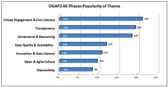
The report itself notes comments came from the Advisory Panel on Open Government, online forums, in-person sessions, email submissions, Twitter (hash tag #OGAP2), and LinkedIn. In general, participants requested quicker, easier, and more meaningful access to their government, and a desire to be involved in government decision making beyond consultations.

Some suggested that the Government of Canada could go even further toward improving transparency in the extractives sector. For example, proposed legislation to establish mandatory reporting standards could stipulate that extractives data be disclosed in open, machine-readable formats based on a standard template with uniform definitions.

figure5-eng

Major themes to emerge from citizen comments on the “What We Heard Report” (Image courtesy of the Government of Canada).

Find out more about this figure or the “What We Heard” report here.

If you have thoughts or questions about the article, get in touch with Drew Bush, Geothink’s digital journalist, at drew.bush@mail.mcgill.ca.

Spotlight on Recent Publications: Interrogating the Nature of Geosocial Data with Stéphane Roche

BEACONS

London Olympic wayfinding beacon (Photo courtesy of www.mudarchitecture.com).

By Drew Bush

In two articles published this January, Geothink researcher Stéphane Roche and his doctoral student Teriitutea Quesnot argue that not all geosocial data is equivalent, and that better data on the social significance of a landmark could greatly enhance our understanding of human wayfinding behavior. A Professor of Geomatics at University of Laval, Roche’s research over the past five years has focused on how new forms of digital spatiality affect spatial reasoning skills, and the capacity of individuals to engage in the city.

Entitled “Measure of Landmark Semantic Salience through Geosocial Data Streams,” the first paper was published by Roche in the ISPRS International Journal of Geo-Information. The authors write that a lot of research “in wayfinding is done in order to enable individuals to reach as quickly as possible a desired destination, to help people with disabilities by designing cognitively appropriate orientation signs, and reduce the fact of being lost.”

Previous researchers in the field of geo-cognition have tried to characterize the salience of landmarks in human wayfinding behaviour. Most have classified differing landmarks by visual, structural and semantic cues. However, the social dimensions of a landmark, such as how they are practised or recognized by individuals or groups, had been excluded from its semantic salience (or often reduced to historical or cultural cues), according to the authors.

Instead, the authors follow in a tradition of research which utilizes text mining from the web to understand how places are expressed by Internet users rather than relying on how they are visually perceived. Such an approach has been made possible by social media and mobile communications technology that has resulted in vast user-generated databases that constitute “the most appropriate VGI data for the detection of global semantic landmarks.”

In conducting their research, the authors examined world famous landmarks and detected semantic landmarks in the cities of Vienna and Paris using data from Foursquare API v2 and Facebook API v2.1. from September 29, 2014 to November 15, 2014.

In a second paper entitled “Platial or Locational Data? Toward the Characterization of Social Location Sharing,” the authors expanded on this theme in arguing that not all geosocial data is equal. The paper was presented at 48th Hawaii International Conference on Systems Sciences this past January.

Some data, which the authors consider “platial,” relates more to users experiences of a given place while “spatial” data is tied to the actual coordinates of a place. In the context of geosocial data, spatial data might mean the exact location of the Eiffel tower while palatial could refer to a person passing by the Eiffel tower or taking a photo of it from another location.

Because each can potentially represent a very different kind of data point, they must be treated differently. As the authors write, “With the objective of a better understanding of urban dynamics, lots of research projects focused on the combination of geosocial data harvested from different social media platforms. Those analyses were mainly realized on a traditional GIS, which is a tool that does not take into account the platial component of spatial data. Yet, with the advent of Social Location Sharing, the inconvenience of relying on a classic GIS is that a large part of VGI is now more palatial than locational.”

Find links to each article along with their abstracts below.

Measure of Landmark Semantic Salience through Geosocial Data Streams

ABSTRACT

Research in the area of spatial cognition demonstrated that references to landmarks are essential in the communication and the interpretation of wayfinding instructions for human being. In order to detect landmarks, a model for the assessment of their salience has been previously developed by Raubal and Winter. According to their model, landmark salience is divided into three categories: visual, structural, and semantic. Several solutions have been proposed to automatically detect landmarks on the basis of these categories. Due to a lack of relevant data, semantic salience has been frequently reduced to objects’ historical and cultural significance. Social dimension (i.e., the way an object is practiced and recognized by a person or a group of people) is systematically excluded from the measure of landmark semantic salience even though it represents an important component. Since the advent of mobile Internet and smartphones, the production of geolocated content from social web platforms—also described as geosocial data—became commonplace. Actually, these data allow us to have a better understanding of the local geographic knowledge. Therefore, we argue that geosocial data, especially Social Location Sharing datasets, represent a reliable source of information to precisely measure landmark semantic salience in urban area.

Platial or Locational Data? Toward the Characterization of Social Location Sharing

ABSTRACT

Sharing “location” information on social media became commonplace since the advent of smartphones. Location-based social networks introduced a derivative form of Volunteered Geographic Information (VGI) known as Social Location Sharing (SLS). It consists of claiming “I am/was at that Place”. Since SLS represents a singular form of place-based (i.e. platial) communication, we argue that SLS data are more platial than locational. According to our data classification of VGI, locational data (e.g. a geotagged tweet which geographic dimension is limited to its coordinate information) are a reduced form of platial data (e.g. a Swarm check-in). Therefore, we believe these two kinds of data should not be analyzed on the same spatial level. This distinction needs to be clarified because a large part of geosocial data (i.e. spatial data published from social media) tends to be analyzed on the basis of a locational equivalence and not on a platial one.

If you have thoughts or questions about the article, get in touch with Drew Bush, Geothink’s digital journalist, at drew.bush@mail.mcgill.ca.

#Geothink Chat Transcript, 20 January 2015

Twitter Chat on #IntellectualProperty, #copyright, and #geodata, hosted by Cheryl Power, PhD student at UOttawa’s Faculty of Law.

Cross-posted from Mapping Mashups.


@geothinkca Jan 20, 2:59pm Welcome all to our #geothink chat, hosted by @cheryldpower on #IntellectualProperty, #copyright, and #geodata! Thanks for joining us!
@cheryldpower Jan 20, 3:00pm Good evening everyone, Cheryl speaking – Let’s hear from the audience who is out there tonight? #geothink #cheryldpower
@mappingmashups Jan 20, 3:00pm Today on #geowebchat we’re joining a chat organized by @geothinkca. Use the hashtag #geothink instead! #geowebchat will be back in 2 weeks.
@re_sieber Jan 20, 3:02pm Can we copyright a geodataset? My understanding is no in US; yes in Canada #geothink
@notgregorypeck Jan 20, 3:02pm #geothink hello all. looking frwrd to discussion with @cheryldpower
@mappingmashups Jan 20, 3:02pm @cheryldpower Hi Cheryl. I work at @stamen making maps with #opendata/#openstreetmap. Also doing a PhD at UBC. #geothink
@AmrEldib Jan 20, 3:03pm @cheryldpower hey, Cheryl. I’m Amr in Vancouver, and wanted to hear all about @geothinkca and #geothink
@cheryldpower Jan 20, 3:04pm @re_sieber #geothink See feist *US
@mappingmashups Jan 20, 3:04pm @cheryldpower I also run #geowebchat… hoping the regular #geoweb audience joins this #geothink chat.
@AmrEldib Jan 20, 3:04pm @re_sieber wouldn’t think be like copyrighting an API which is the topic of dispute between Oracle and Google #geothink
@mappingmashups Jan 20, 3:05pm @cheryldpower We’ve done a few #geowebchats about #opendata. Check out our transcripts after this #geothink chat: mappingmashups.net/geowebchat/
@re_sieber Jan 20, 3:07pm .@cheryldpower I know ab Feist, although it leaves copyright door open for more complicated db structures #geothink
@mhaklay Jan 20, 3:08pm Will it be interesting to explore ODBl opendatacommons.org/licenses/odbl/ for this #geothink discussion?
@JamesLMilner Jan 20, 3:08pm Tuning in to #geothink ; not to hot on IP and copyright but know a little about open source licenses
@cheryldpower Jan 20, 3:09pm @re_sieber #geothink Science technology and IP & Innovation for 10 years !!
@re_sieber Jan 20, 3:09pm @AmrEldib Here’s EFF on copyright case ab copyrighting APIs eff.org/press/releases… #geothink
@cheryldpower Jan 20, 3:10pm @re_sieber #geothink Is it an original selection of data discuss?
@notgregorypeck Jan 20, 3:10pm #geothink can you copyright dataset – according 2 interview with David Fewer, hving a dbase isn’t enough for copyright in CanPost case
@re_sieber Jan 20, 3:12pm Also hot in Canada, copyright case of Canada post v @geolytica cbc.ca/news/technolog… #geothink
@notgregorypeck Jan 20, 3:12pm #geothink intrview with David Fewer – one essential ingrdient for copyright: skill of judgement in selection and arrangement of data
@TenilleEBrown Jan 20, 3:14pm @notgregorypeck Do you have a link for that interview Peck? #geothink
@re_sieber Jan 20, 3:15pm .@notgregorypeck Big diff btwn Canada & US in terms of “sweat of brow” vv copyright #geothink
@re_sieber Jan 20, 3:16pm .@notgregorypeck In Canada, you can count some “sweat of brow” as well as creativity in asserting copyright #geothink
@JamesLMilner Jan 20, 3:16pm ODBI license looks solid but could be more clear about commercial use as per tldrlegal.com is about Apache 2.0, MIT etc #geothink
@geothinkca Jan 20, 3:16pm @TenilleEBrown Here is the link to the #Geothink newsletter, the interview is on page 12!
@cheryldpower Jan 20, 3:17pm Have you been exposed to any type of licensing in association with your research project? #geothink #cheryldpower
@notgregorypeck Jan 20, 3:18pm #geothink CIPPIC, in Geolytica case, are arguing about that disctntion on ‘sweat of brow’. not easy to determine when everything is sftwre
@geothinkca Jan 20, 3:19pm @TenilleEBrown geothink.ca/geothink-newsl… #geothink
@mappingmashups Jan 20, 3:19pm @JamesLMilner Yes, #ODbL was meant to clear up a lot of the commercial use cases for #OSM, but many think it’s still not obvious. #geothink
@cheryldpower Jan 20, 3:19pm @JamesLMilner #geothink Do you have a link?
@ClausRinner Jan 20, 3:20pm Re @re_sieber : What do people think/know about postcodes in OpenStreetMap? Seems a great platform to collect them systematically. #geothink
@cheryldpower Jan 20, 3:21pm @mhaklay #geothink Do you have specific questions? Have you experience with the license?
@re_sieber Jan 20, 3:21pm Copyright in geospatial realm draws on precedence of both pictures (maps), easier to copyright, v. data, difficult to copyright #geothink
@JamesLMilner Jan 20, 3:23pm @mappingmashups interesting. Just read this article about #ODbL issues openstreetmap.org/user/lxbarth/d… #geothink
@mhaklay Jan 20, 3:23pm @cheryldpower No, I don’t have any specific question. Just noticed that it created a lot of noise from different directions! #geothink
@re_sieber Jan 20, 3:23pm .@ClausRinner @geolytica case show us Canada Post asserts copyright over 6 digit postal codes, regardless of collection platform #geothink
@cheryldpower Jan 20, 3:25pm @re_sieber #geothink Tele-Direct v. American Business Information, need original intellectual creation
@re_sieber Jan 20, 3:25pm .@ClausRinner What can be done legally in US vv copyright can’t nec be done legally in Canada. Prob for intl platform lk #OSM #geothink
@mhaklay Jan 20, 3:25pm @cheryldpower e.g. lists.openstreetmap.org/pipermail/lega… or openstreetmap.org/user/lxbarth/d… #geothink vs osmfoundation.org/wiki/License #geothink
@re_sieber Jan 20, 3:28pm .@cheryldpower Tele-Direct case still asserted that min degree of skill in arrangement is protected by copyright under Canada law #geothink
@mappingmashups Jan 20, 3:29pm @ClausRinner @re_sieber Related to postal codes in #OSM is the openaddresses.io project which is a parallel database w/out #ODbL #geothink
@re_sieber Jan 20, 3:30pm .@cheryldpower’s mention of Feist, Tele-Direct highlights that geospatial db law derives from phonebooks #geothink
@TenilleEBrown Jan 20, 3:30pm @JamesLMilner Its aimed at the user of the software? So aimed at informing public what they are able to do with said data-set? #geothink
@re_sieber Jan 20, 3:31pm Welcome @geolytica, to our twitterchat discussion of geospatial data & copyright #geothink
@cheryldpower Jan 20, 3:32pm Do you think there should be any type of IP protection on forms of data for example databases ? #geothink #cheryldpower
@re_sieber Jan 20, 3:33pm .@geolytica has personal experience w the assertion of copyright in Canada vv geospatial data #geothink
@nixzusehen Jan 20, 3:34pm @JamesLMilner spatiallaw.com/Uploads/ODbL_a… #geothink
@mhaklay Jan 20, 3:36pm @cheryldpower maybe IP protection help in securing privacy & control. e.g. indigenous groups geodata – might deter biotech abuse? #geothink
@re_sieber Jan 20, 3:36pm Advertisement: #geothink researches copyright, IP and licenses regarding geoweb (also social justice, particip..). Partners inc CIPPIC, OSM.
@geolytica Jan 20, 3:38pm @re_sieber I recently gave a talk at the state of the map on this topic. #geothink My slides are here: geocoder.ca/onetimedownloa…
@geothinkca Jan 20, 3:38pm @mhaklay Are you referring to biotech companies patenting traditional knowledge? #geothink
@TenilleEBrown Jan 20, 3:40pm @mhaklay @cheryldpower yes to biotech use. As well as abuse of the areas of traditionally owned land #geothink
@mhaklay Jan 20, 3:41pm @geothinkca for example. Beyond biotech, other companies using information about specific plants/resources etc. ? Not sure though! #geothink
@re_sieber Jan 20, 3:41pm .@mhaklay any insight into why UK didn’t go after OSM vv crown copyright violations compared to Canada? #geothink @geolytica
@JamesLMilner Jan 20, 3:44pm further reading implies that ODbL is very patchy indeed; big issues re: when “share-alike” provisions apply spatiallaw.com/Uploads/ODbL_a… #geothink
@re_sieber Jan 20, 3:44pm .@cheryldpower I’d argue that crowdsourced datasets should give IP protections to contributors, including Yelp, fb, TripAdvisor #geothink
@mhaklay Jan 20, 3:45pm @re_sieber @geolytica which violations? OSM community in the UK was vocal to new members about copyright in the early days #geothink
@mhaklay Jan 20, 3:47pm @JamesLMilner this study is funded to support MapBox view of the ODBl issue, so take it with a pinch of salt … #geothink
@re_sieber Jan 20, 3:48pm .@mhaklay ownership not just ab copying. CanadaPost asserting tm over “postal code” o.canada.com/business/canad… @geolytica #geothink
@cheryldpower Jan 20, 3:50pm .@mhaklay #geothink I view the IP & privacy issues through different lens with IP potentially granting exclusive rights in a form of data
@mhaklay Jan 20, 3:51pm @re_sieber @geolytica not yet, because ‘postcodes’ and addresses are a completely messy issue in the UK because of the Royal Mail #geothink
@mhaklay Jan 20, 3:52pm @re_sieber @geolytica see alpha.openaddressesuk.org and …al-government.governmentcomputing.com/news/cabinet-o… as a way to overcome it #geothink
@cheryldpower Jan 20, 3:52pm How do we provide incentives for the open sharing of data? #geothink #cheryldpower
@re_sieber Jan 20, 3:54pm As sidebar to @cheryldpower, a justif for “sweat of brow” inclusion in crown copyright is to protect investment of creator,inc gov #geothink
@mhaklay Jan 20, 3:55pm I wonder if there is any value in studying the discourse at OSM legal talk about lay concepts? lists.openstreetmap.org/pipermail/lega… #geothink
@notgregorypeck Jan 20, 3:56pm .@cheryldpower #geothink probly need alternative revenue streams – open you data, but need that data to feed into use of other services
@re_sieber Jan 20, 3:57pm @mhaklay “studying the discourse at OSM legal talk about lay concepts” sounds like a potential whitepaper to me for #geothink @cheryldpower
@notgregorypeck Jan 20, 3:57pm .@cheryldpower #geothink a Google model for business. provide free service, and tunnel your customers into your other services
@cheryldpower Jan 20, 3:58pm @re_sieber @mhaklay Absolutely we should talk in the days to come #geothink
@geolytica Jan 20, 3:59pm @mhaklay @re_sieber 1M UK addresses, what percentage of the total is that? Our database in Canada currently stands at over 12M. #geothink
@geothinkca Jan 20, 4:00pm @notgregorypeck @cheryldpower Opening data may also crowdsource expensive problem-solving and optimization #geothink
@mhaklay Jan 20, 4:01pm @cheryldpower some ideas from @DrBobBarr about Core Reference Geographies agi.org.uk/storage/events… & agi.org.uk/storage/events…#geothink
@geothinkca Jan 20, 4:02pm Just a few more minutes of this #geothink chat, if you has any more comments! (We’ll return again in the future)
@mhaklay Jan 20, 4:04pm @geolytica @re_sieber en.wikipedia.org/wiki/Postcode_… – 29m addresses #geothink
@re_sieber Jan 20, 4:04pm In future would love to have either #geowebchat or #geothink chat just on licenses.
@geothinkca Jan 20, 4:06pm Thanks evryone 4 joining this #geothink & #geowebchat. Thanks @cheryldpower for hosting. Well be back in th future, stay tuned @geothinkca
@mappingmashups Jan 20, 4:08pm @geothinkca I’ll archive this #geothink chat alongside the other #geowebchats here: mappingmashups.net/geowebchat/ Will post in a few days.
@mappingmashups Jan 20, 4:09pm @re_sieber The next #geowebchat is Feb 3rd. Do we want to talk about licenses then? #geothink
@re_sieber Jan 20, 4:11pm .@mappingmashups Great idea #geowebchat. Licenses for geospatial data #geothink

Special thanks to Cheryl for hosting, and @mappingmashups for mashing #geowebchat chat with our #geothink chat. Love Twitter chats? Have an idea for a Geothink Twitter chat? Get in touch: @geothinkca!

CODE Hackathon Set to Kick-Off as New Report finds the World’s Governments Slow to Open Governmental Data

open-data-mortar-20120416-frontpage

A new year for open data? (Photo Credit: Tactical Technology Collective)

By Drew Bush

In the first weeks of the New Year, two important news items for the Geothink audience made headlines. In Toronto, the Canadian federal government got ready to kick-off its second annual multi-city Canadian Open Data Experience (CODE) while the World Wide Web Foundation ranked the United States 2nd and Canada 7th for openness of governmental data in its second annual Open Data Barometer.

Canada Ranked 7th

Canada tied with Norway out of 86 countries surveyed based on whether government data was “open by default” as stipulated in the 2013 G8 Open Data Charter. Of more importance, however, was the country’s positive movement in the rankings and scores from last year, moving one spot up the index.

The survey examines availability of core government data such as company registers, public sector contracts, land titles, how governments spend money and how well public services perform. The U.K. is considered the global leader for open government data, publishing nearly all of these types of data.

Globally, the authors of the report state “there is still a long way to go to put the power of data in the hands of citizens. Core data on how governments are spending our money and how public services are performing remains inaccessible or pay-walled in most countries.”

That’s because fewer than 8 percent of surveyed countries publish datasets on subjects like government budgets, spending and contracts, and on the ownership of companies, in bulk machine-readable formats and under open re-use licenses.

A few key highlights of the report: 1. Only the U.K. and Canada publish land ownership data in open formats and under open licenses; 2. Only the U.K. and the U.S. publish detailed open data on government spending; 3. And, only the U.S., Canada and France publish open data on national environment statistics. Finally, open mapping data is only published in the U.K., the U.S. and Germany (an area where Canada lags).

CODE Hackathon Kicks-Off

In Toronto, developers, graphic designers, students, and anyone interested in trying their hand at coding are getting ready to create innovative uses for the Canadian government’s open data and to win up to $15,000 from the Government of Canada. The 48-hour event is set to begin on February 20th.

Innovations developed at hackathons like this could one day fuel improvements in access to government data. The event attracted 927 developers in 2013 and that number increased to over 1,000, organizers said, the day of the event.

“Open data is a brand new industry,” Ray Sharma, founder of the event and XMG Studios, told CTV News. “We are in an ice berg situation where we’ve only seen the tip of the data that will become available.”

But just what kind of industry is open to debate, as Geothink researchers Peter Johnson and Pamela Robinson examined in a recent paper. Their questions included whether civic hackathons have the potential to replace the traditional ways that government purchases products and services, and whether these events can be considered new vectors for citizen engagement, according to a post Johnson wrote for Geothink.

For more on CODE, you can watch Canada’s President of Treasury Board, Tony Clement here or read more about this year’s event here.

If you have thoughts or questions about the article, get in touch with Drew Bush, Geothink’s digital journalist, at drew.bush@mail.mcgill.ca.

Geothink Newsletter Issue 5

This Geothink newsletter brings an update for the end of the 2014 year. Inside you’ll find an interview with our partner in the City of Kitchener, highlights from our research team at the University of British Columbia Okanagan, information about two of our Rapid Response Think Tank projects on Open Data Implementation and Geospatial Metadata Standards, and more!

We are working on increasing our media presence, so you can look forward to more media content that will highlight Geothink research. Finally, Geothink students will be hosting more online discussions, such as webinars and Twitter chats. We hope to make these discussion accessible (in terms of content) to everyone in the grant, regardless of your field. Discussions are not restricted to students, so if you are a partner or collaborator and have a topic you wish to host a discussion on, just contact us to set it up.

If you wish to contribute, do not hesitate to get in touch with Peck Sangaimbut.

Geothink Newsletter Issue 5

Canada Action Plan on Open Government 2.0: Much Still To Do?

open_canada_feature_360x203-eng_0

Canada recently completed their public consultation on Open Government (Photo source).

By Drew Bush

Introduction

For the savvy traveller headed over Canada’s border this holiday season, Canada’s Action Plan on Open Government 2.0 holds promise. A visit to the site in December 2014 yielded a multi-media list of steps to follow when travelling abroad and even an iOS “Travel Smart” application.

Drafted after a June 2013 G8 Summit, Canada’s plan results from agreements it made when it signed on to the summit’s Open Data Charter that lays the foundation for usage of open data to promote best government practice.

As a result, Canadians can now get online help with more than just travel. Ever wanted to know how much tax money you spend on government contracts? Or need information on the fuel consumption of a car you might buy?

The goal of the 65 nations committed to these plans is to increase government transparency and accountability, encourage citizen engagement, and stimulate innovation and economic opportunities.

History

Making this type of data more freely available fits with a long tradition in Canada. When the country began participating in the Open Government Partnership (OGP) in September 2011, it committed to making open data (or machine readable, freely used, re-used and redistributed data) open to anyone able to attribute and share it.

Applications of Web 2.0 technologies and social media allow for these types of interactions online with information, datasets and records. In fact, many modern computer programs incorporate Application Programming Interfaces (or APIs) to gain access to datasets for users.

The Open Data Charter recognizes the central role open data plays in improving governance and stimulating innovation in data-driven products and services. It endorses the principle of open by default, an idea also supported by U.S. President Barack Obama’s 2013 Executive Order on open data.

The drafting of the Charter and Obama’s order have elicited praise but also criticism. As Rufus Pollock, Founder of the Open Knowledge Foundation, wrote on his foundation’s blog, “there is still much for the G8, and other countries, to do.” In particular, the early results from an Open Data Census in July 2013 show that G8 countries have a long way to go in opening up essential data.

User Generated Input

Making data and information more available to Canadians isn’t the only goal of the plan. Open government is increasingly becoming a positive force for unity and international cooperation, according to Canada’s President of the Treasury Board, Tony Clement, in his statement “About Open Government”. He claims that open data makes government “more open, accessible, and responsive” by harnessing the “collective ingenuity, drive, and imagination of its people.”

In Canada, this means finding a way for citizens to engage in a two-way dialogue and even contribute datasets. In 2014, the Canadian Open Data Experience appathon again brought together government, industry, academia, and the public to mash up, reuse and remix federal government data. Events like these and communities the plan encourages around interest areas like maps, labour and law help encourage the development of useful, effective applications that use government data.

Short History of Open Government in Canada

  • The Open Government Partnership formally launched on September 20, 2011 when eight founding governments (Brazil, Indonesia, Mexico, Norway, the Philippines, South Africa, the United Kingdom and the United States) endorsed the Open Government Declaration, and announced their country action plans. Canada joined the partnership later that year.
  • On March 18, 2011, the Government of Canada announced its commitment to an open government initiative that focuses on three areas: 1. Making information such as records and activity more easily accessible; 2. Making raw data available in machine-readable formats to citizens, governments, and non-profit/private sector organizations; 3) Giving citizens an opportunity for dialogue on federal policies.
  • In 2011 the Government of Canada launched an Open Data Portal – data.gc.ca – which now has more than 272,000 datasets from 20 departments and which has already resulted in over 100,000 dataset downloads since its launch.
  • All government departments began publishing summaries of completed Access to Information (ATI) requests 2012 monthly on their Web sites.
  • In 2012, the Government of Canada issued its enhanced Values and Ethics Code of conduct for all public officials.
  • A 2013 Government of Canada Social Sciences and Humanities Research Council (SSHRC) partnership grant asks ‘How the Geospatial Web 2.0 is Reshaping Government-Citizen Interactions.’ GeoThink now includes 13 team members and 36 collaborators and partners.

If you have thoughts or questions about the article, get in touch with Drew Bush, Geothink’s digital journalist, at drew.bush@mail.mcgill.ca.