Tag Archives: Research Theme 2: Spatial Authenticity Accuracy and Standards

Bridging Differences in Open Data: Coming up with standards at Open North

Open North has quietly released two reports on open data over the past year.

By Drew Bush

In case you missed either report, over the last year Open North has quietly put out an inventory of open data globally and, in a separate report, recommended baseline international standards for open data catalogs. The first report is entitled Gaps and opportunities for standardization in OGP members’ open data catalogs while the second is entitled Identifying recommended standards and best practicesfor open data.

Their work was completed as part of the Open Government Partnership (OGP) Working Group, a group that aims to support governments seeking transparency through open data. Both reports aim to help the 69 countries in the partnership to improve their ability to share open data by standardizing how it’s made available.

The first report, which inventories open data in OGP’s member countries, notes that most members’ open data initiatives consist largely of open data catalogues. To assess each of these different catalogues, the authors wrote automated scripts to collect, normalize, and analyze them. This process allowed them to set a baseline across countries and identify gaps and opportuni­ties for standardization.

“The analysis simply states the choices that OGP members have made with respect each area for standardization; it makes no judgment as to whether these choices are best practices,” they write in laying out the objectives for the report.

In the second report, the authors address a specific research question: “What baseline standards and best practices for open data should OGP members adopt?” But first they diagnose the problem open data faces globally without any standards.

“The lack of standardization across ju­risdictions is one major barrier; it makes discovering, accessing, using, and integrating data cumbersome and expensive, above the expected return,” they write. “A lack of knowledge about existing standards and a lack of guidance for their adoption and implementation contribute to this situation.”

The majority of the report then seeks to address these problems by outlining baseline standards and best practices for open data catalogs, while taking into account the dif­ferences between jurisdictions that make the global adoption and implementation of standards challenging. In particular, the report concludes with 33 recommendations that member countries should undertake including that governments should provide their agencies a list of acceptable data formats or that they should avoid file compression without good support for it.

To find more of our previous coverage about Open North’s work on open data, check out our previous Geothink.ca story here.

If you have thoughts or questions about this article, get in touch with Drew Bush, Geothink’s digital journalist, at drew.bush@mail.mcgill.ca.

Can Citizen Science Help Cities Address Climate Change?

Photo of people taking noise level readings.

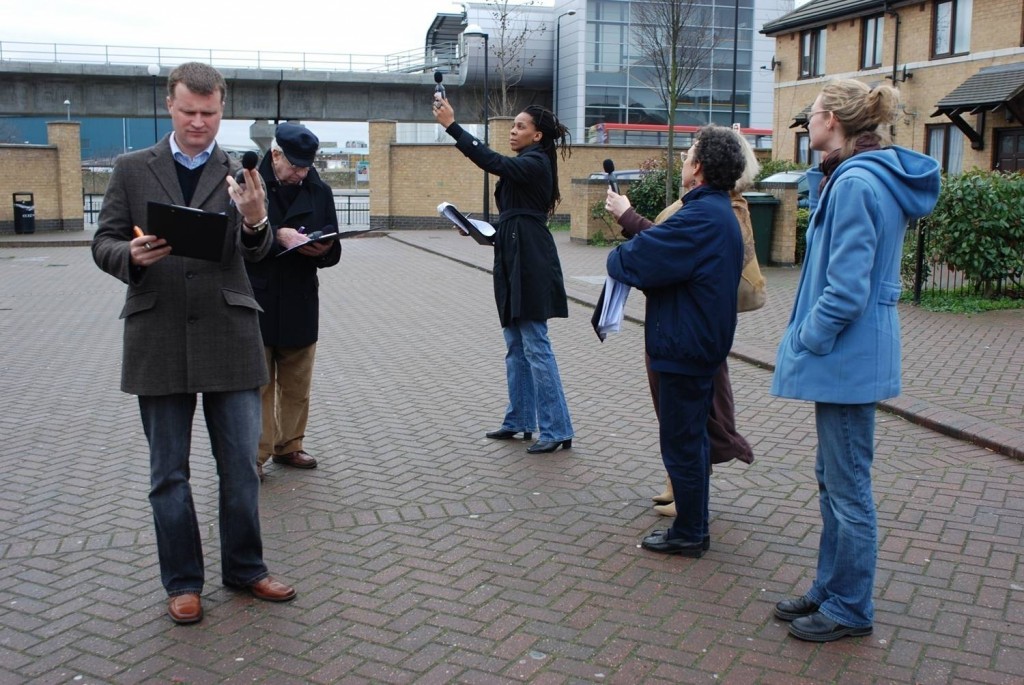
Mapping for Change supports citizen science inquiries into environmental and social issues. Here, participants take noise level readings in regions around a London airport. Photo courtesy Mapping for Change.

By Naomi Bloch

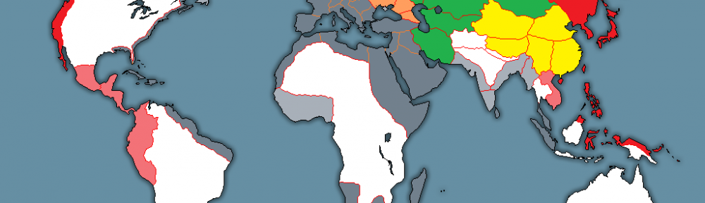
If you were following the recent climate change talks in Paris, you may have noticed a recurring theme: policymakers acknowledging the leadership of subnational governments in addressing climate change. Canada’s own delegation to the conference included representatives from the Canadian Federation of Municipalities, as well as provincial and indigenous leaders.

While the 2015 United Nations Climate Change Conference focused on political negotiations, critics have been quick to remind legislators that more efforts are needed to involve citizens in decision-making. It’s hardly a new idea, but how can civic participation function at a global scale? Activities at the local level may hold the key. Municipalities often have established mechanisms to involve the public in deliberative activities. Cities and their citizens can also collaborate on the evidence-gathering needed to make informed decisions.

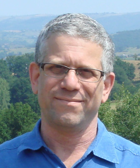
Geothink collaborator Muki Haklay is the director of the University College London’s Extreme Citizen Science group and a professor of Geographic Information Science in the Department of Civil, Environmental and Geomatic Engineering. In 2008, he co-founded Mapping for Change, an organization that uses participatory mapping and citizen science to address environmental and social issues in cities.

Headshot of Muki Haklay

Muki Haklay, professor of Geographic Information Science in the Department of Civil, Environmental and Geomatic Engineering, University College London.

“I see the value of citizen science as part of wider environmental democracy, going back to the Rio conference in 1992,” Haklay explained in an email interview with Geothink. Principle 10 of the Rio Declaration on Environment and Development states that, at national levels, citizens should have “appropriate access to information concerning the environment that is held by public authorities, including information on hazardous materials and activities.” At the community level, the Declaration calls for active and informed public participation in environmental decision-making processes.

Citizen science invites non-professionals to participate in data gathering and the production of new scientific knowledge. “I see citizen science as a new part of the picture,” said Haklay, “where people also participate in creating environmental information that will influence their lives.”

In Haklay’s view, citizen science has particular benefits that can complement traditional research. “The various changes that have occurred in society and technology mean that we can open environmental decision-making further and make it more inclusive and participatory.” As with all research, appropriate rigor and attention to methodology are required. “Not all data should come from citizen science,” said Haklay. “In terms of data quality, citizen science requires us to use appropriate quality assurance methods.”

Mapping for Change provides some helpful exemplars. One collaboration with local organizations has seen thirty different communities across London measuring and mapping air quality data for their neighbourhoods. “We used a whole range of methods: wipe samples, where we checked for heavy metals in dust on different surfaces; diffusion tubes which measure NO2 levels; and bio-indicators — lichens and leaves,” Haklay said. The project’s findings provide location-specific data that can help alert authorities to potential problem zones. “The local authority responded to the results by promising to do their own monitoring in the area and consider how they can manage the traffic in the area.”

Particularly when expensive equipment or lab analysis is needed, resource limitations can create challenges. However, Haklay points out some unique benefits. “Citizen science provides additional information about the context — local knowledge about the place where the monitoring is taking place,” said Haklay. “Participants can also put equipment in their own homes, which is complex for researchers or government agencies.” The citizen science water study in Flint, Michigan, is a good example of this.

Constraints, of course, are not just funding-related. “Not all people would want to do it, and not everyone will have the skills, though we need to consider how to help people in developing them,” Haklay said. “The limitations are the knowledge that people have, their perception of science and their own capabilities, and the abilities of those who manage citizen science projects to engage at such levels. We shouldn’t expect all scientists to be able to facilitate the whole process on their own.”

Haklay suggests that government agencies looking to incorporate citizen science in their data gathering processes should consult the report, Choosing and Using Citizen Science, produced by the UK’s Centre for Ecology and Hydrology. The report reviews resource and management issues, political issues, as well as scientific issues.

The key to citizen science is that it can involve a range of activities. “Participants can help in setting the research question, create protocols that are suitable to their local culture and needs, analyze the information, participate in the production of reports and papers — in short, in everything,” Haklay said. “The value is in making science more open and more collaborative.”

Interested in learning more about Muki Haklay’s citizen science work? Follow him on Twitter: @mhaklay
If you have thoughts or questions about this article, get in touch with Naomi Bloch, Geothink’s digital journalist, at naomi.bloch2@gmail.com.

Moving Forward with Canadian Census Data

By Naomi Bloch


Chloropleth maps of National Household Survey global non-response data at the dissemination-area level courtesy Scott Bell. Global non-response rates > 50% resulted in suppression of data for that spatial unit. All maps are classified using a quantile classification scheme.


As we move forward (and backward) with the 2016 return of Canada’s long-form census, questions remain for everyone who uses Statistics Canada’s key socio-economic data. Researchers, local government agencies, community organizations, and industry will still need to use data collected via the 2011 National Household Survey and understand how to reconcile that information with long-form census data.

Concerns regarding the reliability of NHS data stem from the lower response rates that resulted from the non-mandatory nature of the 2011 survey. The overall response rate for the survey decreased from 94 percent in 2006 to 69 percent in 2011. Media attention has centred on the fact that Statistics Canada chose not to release survey data for 25 percent of all census subdivisions because response rates for those spatial units were too low. A key question is whether the regions for which we have no reliable data share certain socio-economic characteristics — and if so, how this might impact service provision.

Geothink co-applicant researcher Scott Bell, a professor of Geography and Planning at University of Saskatchewan, has been studying and mapping the spatial patterns of the National Household Survey’s global non-response rates. His work examines various geographic levels, and considers response rate patterns relative to several socio-economic variables. Bell found that across the 15 cities he studied, there are many commonalities between areas where response rates are similar.

In this video interview, Bell discusses his research and its implications.

For more from Scott Bell, see also: The Long-term Impacts of the Short-Lived National Household Survey

If you have thoughts or questions about this video interview, get in touch with Naomi Bloch, Geothink’s digital journalist, at naomi.bloch2@gmail.com.

Geothink Video Interview 3: Our Experts Take on Crowdsourcing

Screen Shot 2016-02-24 at 8.34.20 PMBy Drew Bush

We’re excited to bring you our long-awaited video interview that features Geothink’s experts discussing issues of authenticity and accuracy with crowdsourced data.  Data collected through crowdsourcing methods increasingly has replaced traditional forms of data collection.

This video features Geothink Head Renee Sieber, associate professor in McGill University’s Department of Geography and School of Environment; Daren Brabham, assistant professor in the University of Southern California Annenberg School of Journalistm and Communication; Scott Bell, a professor of Geography and Planning at University of Saskatchewan; And, Claus Rinner,a professor and chair of Ryerson University’s Department of Geography and Environmental Studies.

We hope you enjoy this video as much as we enjoyed making it. Afterwards, leave us a comment and tell us what you think about this important area of debate concerning crowdsourced data.

You can also learn more about crowdsourcing by reading our post on this central topic to our 2015 Summer Institute, listening to these lectures from the Summer Institute, or listening to our experts talk about the topic over lunch last June. 

If you have thoughts or questions about this video, get in touch with Drew Bush, Geothink’s digital journalist, at drew.bush@mail.mcgill.ca.

Decision-Making with Uncertain Data

Professor Scott Bell

Director, The Spatial Initiative

University of Saskatchewan

117 Science Place, Saskatoon, SK S7N 3C8

Governments have long provided their citizens with high quality data through centralized services. Generally, these are collected as a population census with an additional and more detailed sampled survey. In Canada, the former is known as the short form census and the latter was called the long form until 2010. The short form provides an accurate count of the total population at the time of the census, while the long form has provided more detailed information about our people. In Canada, the census is collected every 5 years by Statistics Canada (StatsCan), an agency of the federal government. In 2010 an Order in Council altered the past practice of a simultaneous short and long form census to a separate short form and National Household Survey (NHS). The primary difference between the NHS and the long form is that the NHS is not mandatory, whereas the long form was compulsory by law. There have been concerns from many different stakeholders about the value of the NHS as a statistically valid and reliable representation of Canada’s people. StatsCan is not alone in transitioning to a different detailed data collection tool. The US Census has changed the way it collects such data as well; with the introduction of the American Community Survey (ACS). In doing this, they have switched from a decennial short and long form census to a decennial short form census and an annual detailed survey (the ACS). This research will contextualize the introduction of the NHS in Canada with the ACS in the United States.

Mobile Feedback Applications for Base Map Editing

If governments wish to maximize citizen contributions on issues as varied as fixing maps, reporting potholes and commenting on social housing, they likely need easy-to-use tools for citizens to do so. One answer could be on mobile phones. Tool-building is more than a technical issue. Mobile devices have an increasingly central role in our daily activities; they become intermediaries for our interactions with each other, the environment, businesses, and institutions. Recent advances in mobile device and computerized mapping (geographic information system, or GIS) technology have presented us with the potential to develop applications that mediates citizen interactions with government, using geographic base maps as a conduit. This project asks how mobile device technology can allow citizens to contribute to the updating and editing of official maps of their home city. This asserted information would then be incorporated into an authoritative map product. We move beyond the simple citizen-as-sensor or crowdsourcing paradigm to explore how governments not only accept volunteered citizen content (volunteered geographic information, or VGI) delivered through a mobile device, but how citizens become partners with government. This two-way relationship can be formalized through the development of a specific workflow where government workers verify citizen map edits and provide feedback to citizens. In this way, VGI may be integrated into formal governance and decision-making channels.

We anticipate that mobile applications will be the next generation platform for Open 311 and open government. Many issues will arise about their utility and around authentication of data. We want your ideas about and participation in this research! Contact Peter Johnson, pa2johns@uwaterloo.ca, or Rob Feick, robert.feick@uwaterloo.ca.

Accuracy, Authenticity and Technical Aspects of Privacy

At the Universities of Laval and Waterloo, we are interested in what is often seen as the “virtuous cycle” of citizens’ increasing use of open government data and, potentially, for governments to actively leverage information that the public creates. Our work centers on issues of accuracy, authenticity and privacy in citizen-generated spatial data and the changing relationships between governments and citizens in data provision and use. In Year 1, we are concentrating on assembling baseline information that will help us understand how citizens use open data from governments and the extent that Canadian governments’ currently leverage citizen-contributed data. In this first phase, we will assemble a literature review and survey government partners at local, provincial and national levels to:

  1. Identify and characterize the main current open data initiatives (e.g., who is providing what data, in which forms?) and what data standards are used at local and provincial levels (if any?),
  2. Identify existing as well as potential practices for: a) using crowdsourced data (including barriers and opportunities) and, b) for validating crowdsourced data,
  3. Explore the linkages between open data (as a product and as practice) and crowdsourcing at the municipal and provincial levels (e.g. open data not only a service provided by the organization but also a way to improve data and by feedback loops in practice).

Two PhD students (Ashley Zhang – Waterloo, Teriitutea Quesnot – Laval) have been hired to jointly complete the literature review, survey administration and analysis and also participate in reporting the results through a journal paper. Teriitutea Quesnot is from French Polynesia. Teriitutea received his bachelor and masters in France and he has strong geocomputing and programming skills as well as consulting experience. Ashley is from China and has completed her Masters at the University of Georgia with a thesis focus on exploring spatio-temporal changes in the sociao-spatial structure of Beijing. Currently, her PhD research is centred on public engagement and place-making in smart cities. Since our government partners operate in both English and French, the survey will be bilingual to allow a pan-Canadian assessment to be developed. This information relating to current opportunities and barriers will help us develop new methods for promoting and visualizing data authenticity and accuracy. We anticipate that it also will contribute to project-wide efforts to develop best practices for Canadian governments to manage citizen-generated in light of data privacy and quality concerns.

We know that many of our partners and others have considerable experience in utilizing crowdsourced data. Even if you don’t then you probably have questions you’d like explored.

We encourage you to get in touch with us to enrich our research. Feel free to email stephane.roche@scg.ulaval.ca and robert.feick@uwaterloo.ca.