Tag Archives: Peter Johnson

Open Data and Urban Forests – What’s Next?


This is a guest post from Geothink Post Doctoral researcher James Steenberg, Ryerson University School of Urban and Regional Planning, working with Dr. Pamela Robinson.


By James Steenberg, PhD

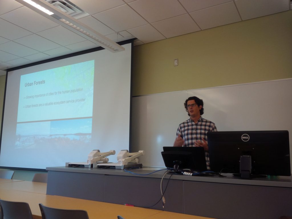
I recently had the opportunity to go on a Geothink summer exchange at the University of Waterloo hosted by Dr. Peter Johnson, a Geothink co-applicant and Assistant Professor at Waterloo’s Department of Geography and Environmental Management. The main goal of the exchange was to learn about open data and open government from Dr. Johnson with the ultimate goal of writing a collaborative paper on the potential role of open data in municipal urban forestry.

I wrote about my experiences during the exchange in a previous post, and subsequently left Waterloo with an open question on open data – can the open data/open government movement also be embraced in urban forestry? I would like to justify this question with two contrasting tales of cities.

Toronto

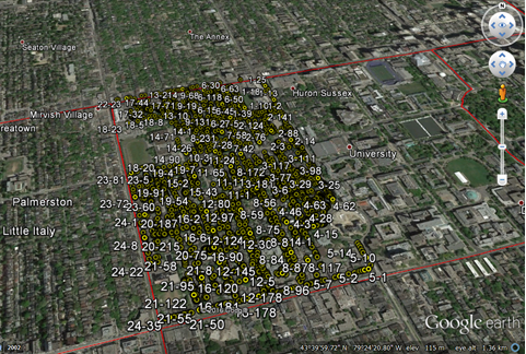
The first tale is about Toronto, more specifically about a neighbourhood in Toronto called Harbord Village where I conducted some of my PhD field research. The neighbourhood and its residents association are quite active in the stewardship of their urban forest. They even undertook a citizen science initiative to inventory and assess all 4,000 of their trees. I re-measured some of their tree inventory in 2014 with the purpose of identifying social and ecological drivers of urban forest vulnerability (e.g., tree mortality). Soon after, my current Geothink supervisor Dr. Pamela Robinson and I began to speculate that a key agent of change was housing renovation. Where we noted incidences of tree mortality, there were often shiny new home additions or driveways where once a tree stood. Fortunately, the City of Toronto’s open data portal includes building permit data and we were able to test this theory. We did indeed find that building permits (i.e., housing renovation) significantly predicted higher rates of tree mortality.

Municipal urban forestry departments are responsible for planting, maintaining, and removing trees on public land, as well as protecting and sustaining the urban forest resource on public and private land through various policies and regulations. However, it’s important to note that urban forestry is plagued by management challenges due to the limited space and harsh growing conditions of cities. Simply put, trees frequently die when they’re not supposed to – often for unknown reasons – and practitioners are continuously seeking out ways to reduce unnecessary tree mortality. Our findings suggest that urban foresters aren’t talking to urban planners when they should be, or vice versa. Urban planners collect data describing where building renovation occurs. Urban foresters collect data describing where city trees are dying and being removed. Blending these datasets has revealed that better coordination and horizontal data sharing across branches of government might help keep public trees alive. More broadly, these findings indicate an inefficiency in municipal service provision – the provision of the beneficial ecosystem services that public trees provide to city residents. What other urban forest inefficiencies might open data reveal?

geothink_harbord_village
The Harbord Village tree inventory and corresponding volunteered geographic information (VGI)

Edmonton

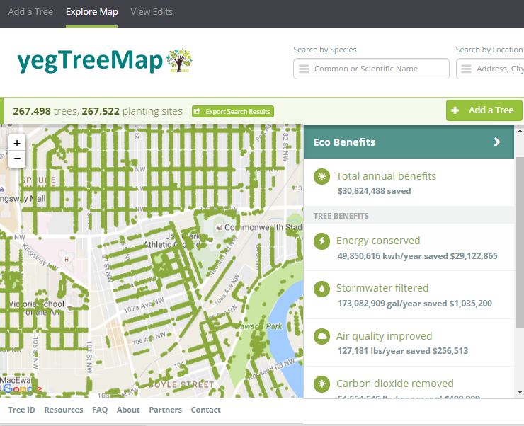
The second tale is about Edmonton and paints a different picture. I stumbled across one of Edmonton’s approaches to urban forestry during my summer exchange while learning about the various open data programs across Canada. Their urban forestry branch has used Open Tree Map – a web-based application for participatory tree mapping – in their yegTreeMap project so that “individuals, community groups, and government can collaboratively create an accurate and informative inventory of the trees in their communities”. In short, citizens in Edmonton that feel the urge to participate in municipal urban forestry can do so by downloading tree inventory data, using the data to their heart’s content (e.g., community-based stewardship programs), and entering new data into the City’s database.

This approach to what I’ve started calling ‘open urban forestry’ could conceivably improve citizen engagement with municipal government and its urban forestry programs. Much of the urban forest resource is situated on private residential property that the city doesn’t have direct access to, so citizen engagement in stewardship activities is a key piece of the puzzle. Moreover, urban tree inventories are notoriously fickle when it comes to data, being both expensive to generate and quick to become out-of-date and obsolete. Crowdsourcing a city’s tree inventory could conceivably provide better data to support decision-making in urban forestry, such as where to plant trees, what species to plant, and where trees are in decline or hazardous.

geothink_edmonton
Edmonton’s yegTreeMap user interface on Open Tree Map

I have been very fortunate to be able to incubate these ideas with guidance from Dr. Robinson and her knowledge of urban planning and citizen engagement. Moreover, it was because of my Geothink summer exchange with Dr. Johnson at the University of Waterloo and his knowledge of open data and open government that I arrived at my current line of thinking on the benefits of open data and crowdsourcing for urban forestry. My next steps forward will be to think critically about these ideas as well. What are the environmental justice implications around who gets to participate in open urban forestry? Crowdsourcing tree inventories through open data programs may provide better data, but do they simultaneously justify the under-funding of municipal urban forestry programs? I’m excited to develop these collaborative ideas over the coming weeks and to hopefully answer my open question on open data.

My sincere thanks to Geothink for giving me the opportunity to go on a summer exchange at the University of Waterloo. Thank you Dr. Peter Johnson for hosting me at the Department of Geography and Environmental Management and for introducing me to your students and colleagues.

To the Geothink community members: please don’t hesitate to contact me if you have further questions or if you are considering going on a summer exchange yourself.

James Steenberg is a postdoctoral researcher under the supervision of Dr. Pamela Robinson at Ryerson University’s School of Urban and Regional Planning. His research focuses on the ecology and management of the urban forest. James can be reached by email – james.steenberg@ryerson.ca – and on Twitter – @JamesSteenberg

Open Data and Urban Forests: A Summer Student Exchange in Waterloo


This is a guest post from Geothink Post Doctoral researcher James Steenberg, Ryerson University School of Urban and Regional Planning, working with Dr. Pamela Robinson. He writes about his experiences in Geothink’s student exchange program.


By James Steenberg, PhD

I recently undertook a three-day Geothink Summer Exchange at the University of Waterloo. My mission: to find out what, if anything, open data has to do with the practice of urban forestry.

I am currently a postdoctoral researcher under the supervision of Dr. Pamela Robinson at Ryerson University’s School of Urban and Regional Planning. Dr. Robinson was also on my PhD committee and over the past three years we have been blending our ideas on urban forest ecosystems, urban planning, citizen science, and open data. Open data and open government, in particular, are something that I’m excited about, but the topic is still quite new and unfamiliar to me. I was therefore incredibly fortunate to have the opportunity to seek out the guidance of Geothink co-applicant Dr. Peter Johnson.

Dr. Johnson is an Assistant Professor at Waterloo’s Department of Geography and Environmental Management, where among a great many other topics he conducts research on the value of open data and its role in open government initiatives. My hope was to learn about open data and open government from Peter and his students with the ultimate goal of writing a collaborative paper about the role of open data in municipal urban forestry. Practitioners of urban forestry are faced with a myriad of management challenges due to the complex, rapidly-changing, and vulnerable state of urban forest ecosystems. Two challenges particular stand out: 1) practitioners lack sufficient data describing the state of the urban forest to inform their decision-making and 2) a large portion of the urban forest is situated on privately-owned residential properties and municipal governments need to engage residents to undertake stewardship activities.

We began the three-day exchange with one of my favourite things to do: having a conversation about how to write something together. This was followed by a meet-and-greet lunch with Dr. Johnson’s students. I was also given the opportunity to give a presentation to students and faculty in Waterloo’s Faculty of Environment. I discussed and received feedback on my current research with Dr. Robinson investigating the effects of housing renewal on urban trees, which was the original research that led us to believe there was more to uncover on open data and urban forests. Over the course of the exchange, I learned about a number of fascinating research projects ranging from citizen engagement to volunteered geographic information (VGI) to water management.

james steenberg student exchange presentation
Giving my talk at the Faculty of Environment, University of Waterloo

james steenberg at waterloo
Rehearsing prior to my talk, with a captivated audience

It can be all too rare an opportunity to hear about on-going research projects that are outside of my discipline, and I found it insightful in guiding my own work. For instance, I learned about Qing (Lucy) Lu’s research and recent publication on how Edmonton citizens engage their government through different communication channels and technologies. Citizens and community groups also engage with their urban forest in many different ways, and arguably open data is one such way that is on the rise. In a serendipitous discovery, Lucy’s paper inspired me to explore Edmonton’s open data portal where I saw that the government leverages open data and the geoweb in their urban forestry. The City’s yegTreeMap initiative not only provides people with open data describing the urban forest and its benefits, but also provides an interactive mapping platform and even allows city residents to input data about their favourite trees.

I wrapped up my time in Waterloo with Dr. Johnson by revisiting a potential paper on the role of open data in municipal urban forestry, which was now appropriately seasoned with new ideas. In particular, I was challenged to think that maybe it’s not just about how urban foresters can use government open data to advance the practice. Perhaps our inquiry could be expanded to the full Geothink mandate of understanding citizen-government interactions. In Edmonton, citizens can engage their government by participating in urban forest data collection while municipal urban foresters can make better decisions with a more complete and up-to-date tree inventory. Can people and trees alike reap the benefits in cities that practice open urban forestry? This is the question I returned home with, and I will continue to investigate until answered.

james steenberg at waterloo 2
Importantly, the University of Waterloo campus has some stunning trees

My sincere thanks to Geothink for giving me the opportunity to go on a summer exchange at the University of Waterloo. Thank you to Dr. Peter Johnson for hosting me at the Department of Geography and Environmental Management and for introducing me to your students and colleagues.

To the Geothink community members: please don’t hesitate to contact me if you have further questions or if you are considering going on a summer exchange yourself.

James Steenberg is a postdoctoral researcher under the supervision of Dr. Pamela Robinson at Ryerson University’s School of Urban and Regional Planning. His research focuses on the ecology and management of the urban forest. James can be reached by email – james.steenberg@ryerson.ca – and on Twitter – @JamesSteenberg

Stay tuned for James’ next post detailing his research.

Geothoughts Talks 4, 5, 6, & 7: Four Talks to Remember from the 2016 Summer Institute

Peter Johnson was one of four Geothink Co-Applicants who gave presentations at the 2016 Geothink Summer Institute. Listen to their lectures here as podcasts.

Peter Johnson was one of four Geothink Co-Applicants who gave presentations on day two of the 2016 Geothink Summer Institute. Listen to their lectures here as podcasts.

By Drew Bush

Geothink’s Summer Institute may have concluded but, for those of you who missed it, we bring you four talks to remember. These lectures come from day two of the institute when four Geothink faculty members gave short talks on their different disciplinary approaches to evaluating open data.

The lectures feature Peter Johnson, an assistant professor at Waterloo University’s Department of Geography and Environmental Planning; Teresa Scassa, Canada Research Chair in Information Law at the University of Ottawa; Pamela Robinson, associate professor in Ryerson University’s School of Urban and Regional Planning; And, Geothink Head Renee Sieber, associate professor in McGill University’s Department of Geography and School of Environment.

Students at this year’s institute learned difficult lessons about applying actual open data to civic problems through group work and interactions with Toronto city officials, local organizations, and Geothink faculty. The last day of the institute culminated in a writing-skill incubator that gave participants the chance to practice communicating even the driest details of work with open data in a manner that grabs the attention of the public.

Held annually as part of a five-year Canadian Social Sciences and Humanities Research Council (SSHRC) partnership grant, each year the Summer Institute devotes three days of hands-on learning to topics important to research taking place in the grant. This year, each day of the institute alternated lectures and panel discussions with work sessions where instructors mentored groups one-on-one about the many aspects of open data.

Below we present you with a rare opportunity to learn about open data with our experts as they discuss important disciplinary perspectives for evaluating the value of it. You can also subscribe to these Podcasts by finding them on iTunes.

Geothoughts Talk 4: Reflecting on the Success of Open Data: How Municipal Governments Evaluate Open Data Programs
Join Peter Johnson as he kicks off day two of Geothink’s 2016 Summer Institute by inviting students to dream that they are civil servants at the City of Toronto when the city receives a hypothetical “F” rating for its open data catalogue. From this starting premise, Johnson’s lecture interrogates how outside agencies, academics, and organizations evaluate municipal open data programs. In particular, he discusses problems with current impact studies such as the Open Data 500 and what other current evaluation techniques look like.

Geothoughts Talk 5: The Value of Open Data: A Legal Perspective

Teresa Scassa starts our fifth talk by discussing how those working in the discipline of law don’t usually participate in the evaluation of open data. While those in law don’t actually evaluate open data, however, legal statutes often are responsible for mandating such valuation, she argues. In particular, legal statutes often require specific types of data to be open. Furthermore, provisions in Canadian law such as the Open Courts Principle mean that many aspects of Canada’s legal system can be open-by-default.

Geothoughts Talk 6: Open Data: Questions and Techniques for Adding Civic Value
Pamela Robinson dispels the notion that open data derives value from economic benefits by instead discussing how such data can be used to fundamentally shift the relationship between civil society and institutions. She elaborates on this idea by noting that not all open data sets are created equal. Right now, she argues, the mixed ways in which open data is released can dramatically impact whether or not it’s useful to civic groups hoping to work with such data.

Geothoughts Talk 7: Measuring the Value of Open Data
In a talk that helps to summarize the previous three presenters, Renee Sieber discusses the different ways in which open data can be evaluated. She details many of the common quantitative metrics used—counting applications generated at a hackathon, the number of citizens engaged, or the economic output from a particular dataset—before discussing some qualitative indicators of the importance of a specific open data set. Some methods can likely capture certain aspects of open data better than others. She then poses a series of questions on how one can actually attach a value to the increased democracy or accountability gained by using open data.

If you have thoughts or questions about these podcasts, get in touch with Drew Bush, Geothink’s digital journalist, at drew.bush@mail.mcgill.ca

Measuring the Value of Open Government Data – Summer Institute Day 2

 Day two of Geothink's 2016 Summer Institute began with short lectures on specific disciplinary perspectives on open data. Teresa Scassa, Canada Research Chair in Information Law at the University of Ottawa, gave a legal perspective on the value of open data.

Day two of Geothink’s 2016 Summer Institute began with short lectures on specific disciplinary perspectives on open data. Teresa Scassa, Canada Research Chair in Information Law at the University of Ottawa, gave a legal perspective on the value of open data.

By Drew Bush

Day two of the 2016 Summer Institute began with presentations from Geothink’s faculty that aimed to provide different disciplinary approaches to evaluating open data. Armed with this information, students spent the rest of the day working in groups to first create measures to value open data, and, second, role-play how differing sectors might use a specific type of data.

The morning began with 30-minute presentations from members of Geothink’s faculty. Peter Johnson, an assistant professor at Waterloo University’s Department of Geography and Environmental Planning, led off with a presentation on how municipal governments evaluate the success of their open data programs.

“This is the situation that we sort of find ourselves in when it comes to evaluating open data,” Johnson told students. “There’s this sort of world outside of government that’s bent on evaluating open data. And those are people like me, academics, those are non-profits, those are, you know, private sector organizations who are looking at open data and trying to understand how is it being used. So this is kind of, I think, a sign that open data has arrived a little bit. Right? It’s not just this sort of dusty, sort of nerdy cobweb in the corner of the municipal government basement. It’s something that other people are noticing and other people are taking an interest in.”

Johnson was followed by Teresa Scassa, Canada Research Chair in Information Law at the University of Ottawa, with a legal perspective on the value of open data. Pamela Robinson, associate professor in Ryerson University’s School of Urban and Regional Planning, gave a civic-oriented approach to the value of open data, one that was intentionally at odds with the private sector.

“I’ll be really blunt, I’m not that interested in making money from open data,” Robinson told students in regard to the common municipal reason for opening data. “It’s important but it’s not my thing. As an urban planner, my primary preoccupation is about citizen’s relationships with their government. And I’m interested in the proposition that open data as an input into open government can fundamentally shift the relationship between civil society and institutions.”

Finally, Geothink Head Renee Sieber, associate professor in McGill University’s Department of Geography and School of Environment, provided a summary of the methods for evaluating open data.

Each of these short lectures were part of a comprehensive look at open data during the three-day institute. Students at this year’s institute learned difficult lessons about applying actual open data to civic problems and on how to evaluate the success of an open data program. In between activities on day two, students also heard from a panel of municipal officials and representatives of Toronto-based organizations working with open data.

Held annually as part of a five-year Canadian Social Sciences and Humanities Research Council (SSHRC) partnership grant, each year the Summer Institute devotes three days of hands-on learning to topics important to research taking place in the grant. This year, each day of the institute alternated lectures and panel discussions with work sessions where instructors mentored groups one-on-one about the many aspects of open data.

But many students struggled not only with thinking about how to evaluate the open data that they were working with, but also with how to determine the impact of any project that utilizes such an information source.

“I think a big challenge that I personally am facing is this idea of it’s supposed to have real improvement for society, it’s suppose to help society,” Rachel Bloom, from McGill University, said. “But we find that a lot of vulnerable populations actually won’t have access to these applications and the technology. So it’s kind of like trying to reconcile this idea of helping while also being aware that like maybe you are not actually reaching the population you are trying to help. Which is kind of what openness is about—is actually engaging the people personally.”

It is for such reasons that evaluating open data can be quite nuanced—an idea represented in student group presentations on the topic. The presentations varied greatly with some student groups choosing metrics based on the things that a community might value and then establishing an outside monitor to observe datasets and report back to the community. Other students established a workflow to harness citizen input to evaluate open data through instruments such as online surveys.

An afternoon panel comprised of local city officials and representatives from groups concerned with open data discussed the practical side of publishing, using, and evaluating open data as it stands today. The panel included Keith McDonald, former open data lead for City of Toronto; Bryan Smith, co-founder and Chief-Executive-Officer of ThinkData Works; Marcy Burchfield and Vishan Guyadeen, from The Neptis Foundation; And, Dawn Walker and Curtis McCord, Geothink students from University of Toronto who designed the Citizen’s Guide to Open Data.

Two of the primary concerns shared by panelists included the lack of standards for which differing municipalities provide open data, and the gap that exists between how open data is provided and what businesses or citizens require to actually use it. Smith spoke of how early visions of students and application developers using open data to radically transform life in cities have not scaled up to the national level particularly well.

“What we are seeing, which I don’t think anyone predicted, is the large companies—mostly companies that run a bunch of apps that probably everyone here has on their phones—are the ones who are the biggest purveyors of open data,” Smith told students. Issues with the type and quantity of data (as well as differences between how data is provided in different places) have limited other players and even some of these big developers too.

For more on this discussion, check out an excerpt of the panel discussion below. We pick up the discussion as the panelists talk about standards in relation to the Open Government Partnership.

In role-playing activities, students considered the issues raised by the panel as well as the practical problems citizens or other groups might face in finding the open data they require. Concluding presentations included those from students playing the role of real estate developers, non-profits concerned with democracy, and a bicycle food courier service.

Stay tuned for the full audio of each professors’ talk presented as podcasts here. Also check back on Geothink for a synopsis of day three, and, of course, watch more of our video clips (which we’ll be uploading in coming days) here.

If you have thoughts or questions about this article or the videos, get in touch with Drew Bush, Geothink’s digital journalist, at drew.bush@mail.mcgill.ca.

Spotlight on Recent Publications: Critical Reflections on Outcomes from Three Geoweb Partnerships

ACME_2015By Naomi Bloch

Exploring university–community partnerships

Participatory geospatial technologies have the potential to support and promote citizen engagement. This great promise has led to more collaborations between academics and community partners interested in pursuing this aim. In their recently published paper, “A web of expectations: Evolving relationships in community participatory geoweb projects,” four Geothink researchers and their colleagues cast a reflective eye on the participatory action research processes behind three completed geoweb partnership projects.

Co-author Jon Corbett, an associate professor in Community, Culture and Global Studies at the University of British Columbia’s Okanagan campus, sees their ACME journal article as helping to fill a gap in the geoweb literature.  “For me, one of the things I’m most interested in is how—in a truthful and well-positioned way—we can talk about the veracity of the work that we’ve done in regards to its ability to actually bring about impact and social change,” Corbett said.
In the article, the authors compare the different cases in order to consider some of the tangible, empirical challenges that the projects encountered, concentrating on the frictions that can occur where technical and social considerations intersect.

screenshot of local food map interface

Central Okanagan Community Food Map interface

Participatory geoweb initiatives commonly rely on out-of-the-box mapping tools. For these three projects, a central aim was to employ the expertise of the university researchers to co-develop and co-evaluate custom geospatial web tools that could address community partners’ objectives. Ideally, such collaborations can benefit all parties. Researchers can learn about the potential and the limitations of the geoweb as a tool for civic engagement while partners have the opportunity to reflect on their objectives and access a wider tool set for accomplishing them. In reality, collaborations require compromises and negotiations. The question then becomes: when are researchers’ academic objectives and partners’ community objectives truly complementary?

In the first case study, the geoweb was used to create a participatory business promotion website for a rural Quebec community, intended as one component of a larger regional economic development strategy. The second case was a collaboration between two university partners and a cultural heritage organization in Ontario. The partners hoped the customized online tool could “serve as a ‘living’ repository of cultural heritage information that was both accessible to the public and could facilitate the contribution of knowledge from the public.” In the third project, university researchers worked with government and grassroots organizations at local as well as provincial levels. The vision in this case was to enable non-expert community members in the Okanagan region to share their own knowledge and experiences about local food and its availability.

Corbett explained that in reflecting on their work, the researchers realized that as social scientists with very specific domains of expertise in political science, geographic information systems, and community research, “the types of skills we needed to negotiate the relationships were far different from the sorts of traditional disciplinary fields that we work in.”  Their collaborators tended to identify the academics more as technical consultants than scholars. As the authors write, “most academics remain untrained in software development, design, marketing, long-term application management and updating, legal related issues, [and] terms of service.”

Although the three collaborations were quite different in terms of the publics involved as well as the negotiated objectives of the projects and the tools employed to achieve them, the authors identified several key common themes. The authors note, “In all three case studies, we found that the process of technology development had substantial influence on the relationship between university developers and community organization partners. This influence was seen in the initial expectations of community partners, differential in power between researcher and community, sustainability of tools and collaborations, and the change from research collaboration towards ‘deal making.'”

In the end, Corbett said, “All of the projects were extremely precarious in how we could assign value or success to them. The paper was really an academic reflection on the outcomes of those three different projects.”

Abstract

New forms of participatory online geospatial technology have the potential to support citizen engagement in governance and community development. The mechanisms of this contribution have predominantly been cast in the literature as ‘citizens as sensors’, with individuals acting as a distributed network, feeding academics or government with data. To counter this dominant perspective, we describe our shared experiences with the development of three community-based Geospatial Web 2.0 (Geoweb) projects, where community organizations were engaged as partners, with the general aim to bring about social change in their communities through technology development and implementation. Developing Geoweb tools with community organizations was a process that saw significant evolution of project expectations and relationships. As Geoweb tool development encountered the realities of technological development and implementation in a community context, this served to reduce organizational enthusiasm and support for projects as a whole. We question the power dynamics at play between university researchers and organizations, including project financing, both during development and in the long term. How researchers managed, or perpetuated, many of the popular myths of the Geoweb, namely that it is inexpensive and easy to use (thought not to build, perhaps) impacted the success of each project and the sustainability of relationships between researcher and organization. Ultimately, this research shows the continuing gap between the promise of online geospatial technology, and the realities of its implementation at the community level.

Reference: Johnson, Peter A, Jon Corbett, Christopher Gore, Pamela J Robinson, Patrick Allen, and Renee E Sieber. A web of expectations: Evolving relationships in community participatory geoweb projects. ACME: An International E-Journal for Critical Geographies, 2015, 14(3), 827-848.

If you have thoughts or questions about this article, get in touch with Naomi Bloch, Geothink’s digital journalist, at naomi.bloch2@gmail.com.

Geothoughts 7: Unpacking the Current and Future Value of Open Civic Data

Geothink researcher Peter Johnson and his students have been working with government partners across the country to examine the state of civic open data projects in Canada.

Geothink researcher Peter Johnson and his students have been working with government partners across the country to examine the state of civic open data projects in Canada.

By Naomi Bloch

Peter Johnson image

Peter Johnson, assistant professor in the University of Waterloo Department of Geography and Environmental Management, was recently awared Ontario’s Young Researcher Award.

Geothink co-applicant researcher Peter A. Johnson is an assistant professor of Geography and Environmental Management at the University of Waterloo. Johnson and his students have been working with Geothink government partners across the country to examine the state of civic open data projects in Canada. In our latest podcast, he discusses how the seemingly desirable ethos of open data may nonetheless hamper our understanding of how end users are interacting with government products.

In their July article published in Government Information Quarterly, Johnson and Geothink head Renee Sieber discuss what they see as the dominant models—and related challenges—of civic open data today. The authors suggest that these models may carry potentially conflicting motivations. Governments can distribute data and leave it to users to discover and determine data’s value, they may aim to track civic issues in ways that are cost efficient, or they may also try to support market innovation via data provision and the promotion of crowd-sourced contributions. On the other hand, open data efforts also have the potential to enable productive and empowering two-way civic interactions when motivated by non-economic imperatives.

What future directions will government data provision take? That may depend a lot on the choices that government agencies—and end users—make today.


If you have thoughts or questions about this podcast, get in touch with Naomi Bloch, Geothink’s digital journalist, at naomi.bloch2@gmail.com.

Reference
Sieber, R. E., & Johnson, P. A. (2015). Civic open data at a crossroads: Dominant models and current challenges, Government Information Quarterly, 32(3), pp. 308-315. doi:10.1016/j.giq.2015.05.003. OR: View pre-print copy.

Abstract
As open data becomes more widely provided by government, it is important to ask questions about the future possibilities and forms that government open data may take. We present four models of open data as they relate to changing relations between citizens and government. These models include; a status quo ‘data over the wall’ form of government data publishing, a form of ‘code exchange’, with government acting as an open data activist, open data as a civic issue tracker, and participatory open data. These models represent multiple end points that can be currently viewed from the unfolding landscape of government open data. We position open data at a crossroads, with significant concerns of the conflicting motivations driving open data, the shifting role of government as a service provider, and the fragile nature of open data within the government space. We emphasize that the future of open data will be driven by the negotiation of the ethical-economic tension that exists between provisioning governments, citizens, and private sector data users.

Geothink Researcher Peter Johnson Honored with Early Researcher Award from the Government of Ontario

Peter Johnson undertakes the Public Lab of Open Technology and Science (PLOTS, or simply ‘Public Lab’) balloon mapping technique to test it for future use in a class.

Peter Johnson undertakes the Public Lab of Open Technology and Science (PLOTS, or simply ‘Public Lab’) balloon mapping technique to test it for future use in a class.

By Drew Bush

Peter Johnson, assistant professor of Geography and Environmental Management at the University of Waterloo, was honoured with the Ontario Government’s Early Researcher Award for his project, Measuring the Value and Impact of Open Data. Johnson was one of two professors in his department that were funded.

Peter Johnson, assistant professor in the University of Waterloo Department of Geography and Environmental Management, was recently awared Ontario's Young Researcher Award.

Peter Johnson, assistant professor in the University of Waterloo Department of Geography and Environmental Management, was recently awarded Ontario’s Early Researcher Award.

In the project, Johnson will build partnerships with stakeholders, develop case studies to measure the impact of open data initiatives, and assess how open data generates economic and social benefits. Ontario’s provincial and municipal governments now prioritize the sharing of open government data, like many North American communities.

And right now is a key time for evaluating the impacts of such data, Johnson told Geothink this past June at the University of Waterloo.

“I think we’ve reached a spot in open data provision where we understand the technical challenges to providing open data and some of the organizational challenges as well,” he said of his and his students’ work. “But it’s trying to understand what is the impact that open data provision is having. So trying to follow data from just being provided on a web site and a download portal to understanding are community groups using it, is the private sector using it, are other governments using it, or even is it being used internal to the government that’s providing it?”

Johnson’s research may impact how Ontario and other governments one day share open data and the way private developers, nonprofits, and citizens build applications and businesses using such data.

Other areas of research for Johnson and his students include looking at the use of government 311 applications that help citizens report overflowing garbage cans in a local park or if a particular sidewalk might need to be shoveled. Their research questions why governments are developing these applications and using them, the type of data such applications gather, and how this data can be used to improve government processes.

“Is this an opportunity for citizens to express their opinions on different potential developments or to connect with their elected officials?” he asked. “And how does this official channel compare to something that’s unofficial like Twitter?”

“What I’m really interested in is looking at is balancing citizen input that is delivered in these different ways,” he added. “So which one gets the results? Tweeting at your counselor or using the official government branded app to report your pothole at the end of your street?”

In addition to this research, Johnson published a paper with Geothink Head Renee Sieber, associate professor in McGill’s Deptartment of Geography and School of Environment,  this past July in Government Information Quarterly entitled “Civic open data at a crossroads: Dominant models and current challenges.

On his personal Web site, he writes that in this piece, “We take a look at the dominant models of open data provision by government and start to lay out what the challenges are for delivering open data. We tried to make this both a reflective look at where open data is, and also to push civic open data forward, examining how open data works as part of open government strategies.” Find a pre-print copy available here and also find the abstract below.

The award, given to 822 early career researchers since 2005, was given by the Ontario Ministry of Research and Innovation and The Ontario Research Fund – Small Infrastructure programs. The province will spend $209 million this year to support research projects and talent at research institutions across the province. This year’s successful 280 successful projects were chosen based on their research excellence and their economic and societal benefits for Ontario.

If you have thoughts or questions about this article, get in touch with Drew Bush, Geothink’s digital journalist, at drew.bush@mail.mcgill.ca.

Abstract
Civic open data at a crossroads: Dominant models and current challenges.
As open data becomes more widely provided by government, it is important to ask questions about the future possibilities and forms that government open data may take. We present four models of open data as they relate to changing relations between citizens and government. These models include; a status quo ‘data over the wall’ form of government data publishing, a form of ‘code exchange’, with government acting as an open data activist, open data as a civic issue tracker, and participatory open data. These models represent multiple end points that can be currently viewed from the unfolding landscape of government open data. We position open data at a crossroads, with significant concerns of the conflicting motivations driving open data, the shifting role of government as a service provider, and the fragile nature of open data within the government space. We emphasize that the future of open data will be driven by the negotiation of the ethical-economic tension that exists between provisioning governments, citizens, and private sector data users.

Civic Hackathons: Innovation, Procurement, or Civic Engagement?

By Peter Johnson

I’ve recently published a jointly-authored viewpoint piece with Dr. Pamela Robinson from Ryerson University in Review of Policy Research. Titled ‘Civic Hackathons: Innovation, Procurement, or Civic Engagement?‘, we take a critical look at the recent phenomenon of civic hackathons – time limited contests typically run by governments designed to promote use of open data resources, and potentially solve local issues.

Both Pamela and myself have been struck by the high level of interest and hype that many civic hackathons have received, and decided to examine the multiple end points and implications generated from these events. For example, do civic hackathons have the potential to replace the traditional ways that government purchases products and services? Similarly, are these events considered to be new vectors for citizen engagement, and if so, who is actually participating in them, and for what purposes? This is a rich area for future questions, as this paper provides guidance towards a more fully developed research program that critically evaluates the hackathon process and outcomes.

Peter A. Johnson
Assistant Professor
Department of Geography and Environmental Management
University of Waterloo

Cross post from Geospatial Participation