Author Archives: Drew Bush

A First Hand Account of McGill University’s Team-CODE’s Experiences in the 1st Annual ECCE App Challenge hosted by Environmental Systems Research Institute (ESRI)

By Jin Xing

I was one of three Geothink students who competed in the Environmental Systems Research Institute’s (ESRI) ECCE 1st Annual App Challenge hosted by the institute’s Canada Centre of Excellence. Team CODE-McGill, which consisted of McGill University students Matthew Tenney, Carl Hughes, and myself placed second in the competition that concluded on March 20 with the announcement of a winning group from the University of Waterloo.

Although our three team members each has a different research interest, each of us studies topics related to open data. Our Community Open Data Engage (CODE) application was sparked by an exchange I had with Hughes when we discovered we both call Toronto, Ontario home after the competition had already begun. In fact, it was only after Hughes told me that my neighbourhood was “a better” place to live that we began to interrogate the question of how to evaluate a community using open data.

As we worked on our submission, we noticed that community-level open data attracts more attention than data on the whole city. In particular, we found citizens were more concerned with data on traffic, education, and recreation resources in their own neighbourhoods compared to other types of data. Our creation: A new approach for exploring a community using an open data platform that connects people and communities.

However, the application that we designed required a number of trade-offs to be decided in the span of only one week. First, we struggled to choose whether to include more data or to favour an easy-to-use interface. In particular, we wanted to develop functionality to integrate a greater variety of community data but didn’t want the application to become too hard to use. After several hours of discussion, we decided to favour an approach that centered on making open data “easy and ready to use.”

The second trade-off involved the selection of ESRI JavaScript APIs. In particular, we had to choose ESRI ArcGIS API or ESRI Leaflet for open data integration and visualization. At the beginning, I preferred the ArcGIS API due to its rich functions. But Tenney pointed out it was actually over-qualified and may delay the page loading which caused the team to decide to use Leaflet.

Finally, we had to decide how to integrate social media. In particular, we needed to decide whether the Twitter content should be loaded from data streaming or just retrieved from the back-end. All of us felt it was cool to have a real-time Twitter widget on our application’s page, but we didn’t know how to get it to choose the right tweets. For example, a user named Edmonton might say nothing about the City of Edmonton city, and our code would have needed to filter it out in real-time. Considering the difficulty of developing such a data filtering AI in one week, we decided to include it only on the back-end. To accomplish this, we used Python to develop a way to harvest and process data, while the ESRI Leaflet handled all the front-end data integration and visualization.

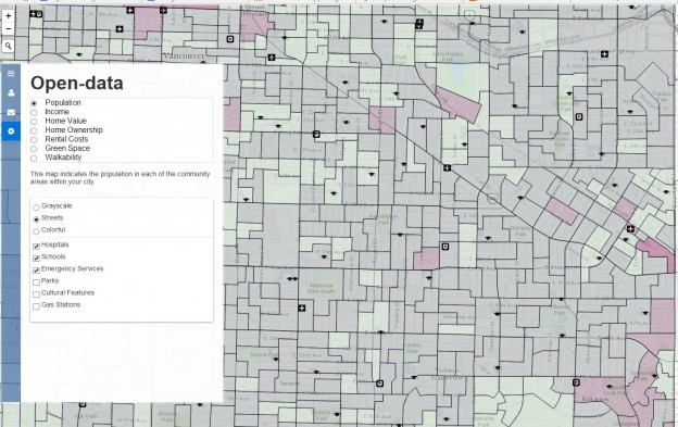
Our application included data on school locations, health facility locations, grocery store locations, gas station locations, green space, cultural facilities, emergency services, census dissemination areas and Twitter data, all of which were presented as different map layers. We employed the Agile developing method for CODE, meaning we quickly built the prototype for CODE and tested it, then repeated this process with additional functions or by re-developing bad code.

In actuality, though, we built three prototypes in the first two days and spent another two days for testing, selecting and re-developing. The Agile method helped us keep CODE always functional and easy to extend. The only drawback of using Agile was the local code synchronization become necessary before we pushed it to GitHub. If two of us pushed at the same time with different code, our GitHub would be massed up. By late Thursday night, we had nearly finished all the planned coding and had even begun to improve the user experience. The search widget and navigation buttons were added in the last day to make open data easy and ready for use in our CODE application.

We felt that by putting information in the hands of concerned citizens and community leaders, CODE is a proof-of-concept for data-driven approaches to building a strong sense of communityacross cities. CODE also connects people and governments by allowing them to create forums for conversation in specific communities across a city or search social media sites to find other people in their area.

Furthermore, by integrating and visualizing open data at a community scale, CODE demonstrates a new approach for community exploration. In fact, users can search and select different open data for certain communities on one map, and corresponding statistics are shown as pop-ups. In the initial phase, we provided this community exploration service for citizens in Edmonton and Vancouver.

Overall, I felt attending this ECCE App challenge was a great experience to integrate ESRI web technologies with open data research. It proves open data can act as the bridge between citizen and cities, and that ESRI products significantly simplify the building of just such a bridge. We believe more applications will continue to be inspired by the ECCE App challenge and that open data will become closely used in everyday life. Thanks to ESRI, we got a chance to help shape the next-generation of community exploration.

If you have thoughts or questions about this article, get in touch with Jin Xing, Geothink’s Information Technology Specialist, at jin.xing@mail.mcgill.ca.
Spotlight on Recent Publications: Exploring the Hyperbole Behind Crisis Mapping Through Chronic Community Development Issues

By Drew Bush

McGill University Masters Student Ana Brandusescu, lead author on the paper "Confronting the hype: The use of crisis mapping for community development."

McGill University Masters Student Ana Brandusescu, lead author on the paper “Confronting the hype: The use of crisis mapping for community development.”

In a paper published this month, Geothink researchers critically examined the role that crisis mapping software such as Crowdmap can play when used to instead facilitate development issues in three Canadian communities in Vancouver and Montreal. They argue that such platforms hold many technological constraints, including an intrinsic short-term feel that makes it difficult to deploy on the chronic, long-term issues common to community development.

Entitled “Confronting the hype: The use of crisis mapping for community development,” the paper was published in Convergence: The International Journal of Research into New Media Technologies by McGill University Masters Student Ana Brandusescu and Associate Professor Renee Sieber along with Université du Quebec à Montréal Professor Sylvie Jochems. Please find the abstract below.

Each of the case studies examined in the paper involved a different set of circumstances. In Montreal, the researchers worked with a community of low-income immigrants in single-family homes who predominantly spoke French. In contrast, one community in Vancouver consisted of young middle-class families living in subsidized student housing while the other was an ethnically diverse low-income community living in rented housing. Both Vancouver communities predominantly spoke English.

“The Vancouver cases had issues resembling crises, for example, immediate rezoning, antidensification, and loss of social housing,” the researchers wrote in the paper. “The Montreal organizers wished to address longer term issues like the recording of community assets.”

In each community, the researchers prepared participants at initial community meetings by using storyboards or comic books to explain the process of mapping. Furthermore, a manual they created helped application managers and community members understand how to manage the application, submit reports (via texts, tweets, Web reports, e-mails and smartphone message), geolocate reports, and handle messages that might contain personal identifiers or foul language. In Vancouver, the managers consisted of community activists while in the Montreal case the managers were part-time professional community organizers.

Although each community differed in their implementation of the mapping software and program, the findings were striking.

“In this article, we explored the reality behind the hype of crisis mapping and revealed that hype through its repurposing to community development,” they write in their conclusion. “We confronted the zero-cost argument and found numerous technology constraints, which confirmed the challenges of introducing a new technological medium to community development processes.”

“Burns asserted that knowledge politics concerns the role of power in developing a map but the politics also refers to the overall hype to which we so easily succumb,” they add later in their conclusion in reference to a paper by a researcher at the University of Washington, Ryan Burns, entitled Moments of closure in the knowledge politics of digital humanitarianism. “If we acknowledge and then work past the hype then perhaps we will achieve more meaningful and sustainable systems.”

Abstract
Confronting the hype: The use of crisis mapping for community development
This article explores the hyperbole behind crisis mapping as it extends into more long term or ‘chronic’ community development practices. We critically examined developer issues and participant (i.e. community organization) usage within the context of local communities. We repurposed the predominant crisis mapping platform Crowdmap for three cases of community development in Canadian anglophone and francophone. Our case studies show mixed results about the actual cost of deployment, the results of disintermediation, and local context with the mapping application. Lastly, we discuss the relationship of hype, temporality, and community development as expressed in our cases.

If you have thoughts or questions about the article, get in touch with Drew Bush, Geothink’s digital journalist, at drew.bush@mail.mcgill.ca.

Geothoughts 4: Have We Broadened the Audience? Civic Participation in an Age of Digital Technology

Geothoughts 4 examines how civic participation is changing with the advent of geospatial digital technologies.

Geothoughts 4 examines how civic participation is changing with the advent of geospatial digital technologies.

By Drew Bush

We’re very excited to present you with our fourth episode of Geothoughts. You can also subscribe to this Podcast by finding it on iTunes.

This podcast examines how civic participation is changing with the advent of geospatial digital technologies that allow for cities to collect many forms of data on their citizens and for citizens to communicate with cities and about all that happens within them. We interview Geothink’s Head Renee Sieber, Associate Professor in McGill University’s Department of Geography and School of Environment, to find out her opinions on this subject.

Thanks for tuning in. And we hope you subscribe with us at Geothoughts on iTunes. A transcript of this original audio podcast follows.

TRANSCRIPT OF AUDIO PODCAST

This week we sit down with Geothink Head Renee Sieber to discuss how geospatial digital technology continues to reshape citizen interactions with cities. Sieber is an associate professor in McGill University’s Department of Geography and School of Environment.

[Geothink.ca theme music]

Welcome to Geothoughts. I’m Drew Bush.

“It’s a very different world in which we can on a Saturday evening or an early Monday morning know what’s happening in our cities and comment on what’s happening in cities. It’s technologies like sensors in road networks that allow cities to know how we’re travelling through a town, where we are meeting up with people to, for example, create dynamic neighborhoods of where people congregate and want to see their friends to then create better urban design for cities. So the technology is really transforming the way we can have this interaction.”

For example, governments can now know if you visit certain parks, go to certain places for coffee, and meet certain friends while doing either. So, theoretically at least, they can now design urban spaces and cities themselves to be safer, more vibrant, and better suited to the range of activities taking place in these places.

“Indeed, we can customize the city to individual desires. Well, that seems both incredibly convenient and incredibly Orwellian at the same time.”

Now in the third year of a five-year partnership research grant funded by the Canadian Government’s Social Sciences and Humanities Research Council, Geothink involves 26 researchers and 30 partners in examining the implications of increasing two-way exchanges of locational information between citizens and governments.

“Cities are facing tremendous budget cuts, so they may not, they literally may not have the money to have lengthy public meetings. They may need to respond quite rapidly to challenges, so they may not have the time. So it is in everyone’s best interest to try to create smooth yet meaningful interactions, and we have technologies to do that—both technologies in terms of your phone and also technologies in the imbedded infrastructure of cities. But how is that going to affect a very deep meaningful conversation, and in deep meaningful ways that cities respond to the needs of their residents and the needs of factors outside their municipalities?”

That’s where the interdisciplinary research of Geothink’s team and collaborators as well as its partnerships with many cities come in, said Sieber. All of these new interactions and ways of governing or being a citizen require research to be better understood.

“Well it’s a really exciting time. It’s an opportunity for citizens to be engaged when they don’t necessarily have the time to attend a meeting. So they can both watch city activities online through their own dashboards. They can communicate as issues arise. They can, perhaps cities may wish to create polls of online sentiment or they want to alert citizens of emergency situations or of interesting happenings in a city.”

Not all applications of new digital technologies have positive connotations. For example, these technologies make it easier for cities to conduct better surveillance of citizens since they can track people through the cell-phones they carry or by the places they check into.

Such privacy concerns have the potential to make people very uncomfortable, particularly because it means placing more trust in governments and technologies that could misuse or abuse this data, according to Sieber. Other problems include the mistaken belief that new technologies mean more people can access and interact with their cities. While efforts to take some conversations or debates online might be advantageous to certain populations, it can also be disenfranchising to others, Sieber added.

However, that doesn’t mean that more digital opportunities haven’t translated into more opportunities for citizens to interact with their cities and their services.

“I think we are in an environment in which we have really broadened opportunities for citizens to participate through social media, through these various kinds of devices that we have. So I think its very exciting and also we can have citizens more fully engaged as members of the city in reporting in monitoring events in real time.”

However, Sieber cautions that we must remember technology is not a panacea.

“Democracy can be very, very messy, and sometimes you need to get people who don’t necessarily agree with each other in the same room with each other. You can not necessarily rely totally on harvesting, for example, Tweets or Facebook posts to understand public sentiment. Democracy and perceptions about what a city should do are often much more textured than that.”

[Geothink.ca theme music]

[Voice over: Geothoughts are brought to you by Geothink.ca and generous funding from Canada’s Social Sciences and Humanities Research Council.]

###

If you have thoughts or questions about this podcast, get in touch with Drew Bush, Geothink’s digital journalist, at drew.bush@mail.mcgill.ca.


Geothoughts 3: Edmonton Ascending to the World Stage as a Truly Open City

Edmonton is working to be on par with the world’s smart cities through an open city initiative that will revolutionize the life of the city’s citizens.

Edmonton is working to be on par with the world’s smart cities through an open city initiative that will revolutionize the life of the city’s citizens.

By Drew Bush

In our third edition of Geothoughts, we’re excited to bring you an interview with Yvonne Chen, a strategic planner for the city of Edmonton’s Open City Initiative. You can also subscribe to this podcast by finding it on iTunes.

In this interview, we talk with Chen about what it means for Edmonton to be on par with the world’s smart cities, the open city initiative due before the Edmonton City Council and future projects that will revolutionize the life of the city’s citizens.

Thanks for tuning in. And we hope you subscribe with us at Geothoughts on iTunes. A transcript of this original audio podcast follows.

TRANSCRIPT OF AUDIO PODCAST

Welcome to Geothoughts. I’m Drew Bush.

[Geothink.ca theme music]

Edmonton’s City Council has yet to consider an Open City Initiative that may cement the city’s status as one of the world’s newest smart cities. But as we wait for the council to take action, we bring you a deeper look at the Initiative from Yvonne Chen, a strategic planner for the city who has helped orchestrate the Initiative.

“Edmonton is aspiring to fulfill its role as a permanent global city, which means innovative, inclusive and engaged government. So Open City acts as the umbrella that encompasses all the innovative open government work within the city of Edmonton.”

That was Chen in an article published on Geothink.ca a few weeks ago. Her work on the initiative follows close on the heels of a 2010 decision by city leaders to be the first to launch an open data catalogue and the 2011 awarding of a $400,000 IBM Smart Cities Challenge award grant.

In March, the city cemented a partnership with Startup Edmonton when they announced the Open Labs project to connect city staff with the six-year-old group to work on solving problems using the city’s data. Startup Edmonton’s aim is to bring developers, designers, makers, founders, investors and mentors together in one place with a goal of using their strengths collaboratively to encourage the development of startup companies based on technological innovation.

For the city, some initiatives have included using advanced analysis of open data streams to enhance crime enforcement and prevention, and interactive neighborhood maps that will help Edmontonians locate and examine waste disposal services, recreational centers, transit information, and capitol projects. In fact, one of Edmonton’s most notable projects has included providing free public Wi-Fi around the city’s LRT stations, with plans for an expansion to all trains and tunnels.

However, not all of the city’s efforts have worked exactly as planned. In particular, questions have been raised by the city council about the sheer volume of smartphone applications that have been developed by the city and the efficacy of some of them. City officials believe the collaboration may serve to fix this, or at least reduce the cost of when they don’t work as planned, according to The Edmonton Sun.

For Chen, the release of the Open City Initiative represents the culmination of years of work.

“My role throughout this entire release was I was helping to conduct the public consultation sessions, I was analyzing information, and I was writing the Open City initiative documents as well as a lot of the actual policy itself.”

In fact, the document outlines city policy, action plans for specific initiatives, environmental scans (or reviews), and results from public consultations on city initiatives. More than 1,800 Edmontonians commented on the initiative last October before it was revised and updated for the Council.

“The city of Edmonton’s Open City Initiative is a municipal perspective of the broader open government philosophy… It guides the development of innovative solutions in the effort to connect Edmontonians to city information, programs, services and any engagement opportunities.”

Like many provincial and federal open city policies, the document focuses on making Edmonton’s government more transparent, accountable and accessible. Unlike such policies, Chen said, it also focuses on including citizens in the design and delivery of city programs and services through deliberate consultations, presentations, public events and online citizen panels. In fact, more than 2,200 citizens are on just the panel asked questions by city officials as they design the initiative’s infrastructure.

And just as the Canadian Government celebrated it’s second annual CODE Hackathon this past February, Edmonton hosted its second annual city hackathon on February 21st.

“We had more than fifty participants actually stay the whole day and develop different mobile applications and other projects. Some of the more technological-based solutions used the city’s open data catalogue.”

Some of these applications may one day hit the city’s streets. Of interest, according to Chen, are one team’s project to consolidate all of the city and affiliated organization’s disparate Twitter feeds into one Twitter box that citizens can personalize, and a project that made use of multiple data sets to allow users to rank neighborhoods by socio-demographic variables for a variety of purposes including determining what types of schools are nearby.

[Geothink.ca theme music]

[Voice over: Geothoughts are brought to you by Geothink.ca and generous funding from Canada’s Social Sciences and Humanities Research Council.]

###

If you have thoughts or questions about this podcast, get in touch with Drew Bush, Geothink’s digital journalist, at drew.bush@mail.mcgill.ca.

Our Take: Geothink at the Association of American Geographers (AAG) Annual Meeting 2015

By Drew Bush

Andrea Minano at the Association of American Geographers (AAG) Annual Meeting in Chicago, Illinois.

Andrea Minano at the Association of American Geographers (AAG) Annual Meeting in Chicago, Illinois.

From April 21 to April 25 2015, Geothink’s students, team, and collaborators presented their research and met with colleagues in Chicago, Illinois at the now concluded 2015 Association of American Geographers (AAG) Annual Meeting. Over the week, Geothinkers gave 16 presentations, ran a panel discussion, presented posters, organized and chaired four sessions, and gave two plenary speeches. See who attended here.

“The AAG is always an excellent conference but this year I think was the best one I’ve attended,” Harrison Smith, a PhD candidate at the University of Toronto, wrote in an e-mail to Geothink.ca. “The Geothink community was in full force and we gave some excellent presentations that definitely put us on the map.”

Of his own work, Harrison reported positive results as well. Find his abstract here and below.

“I received some very excellent questions and positive feedback from the audience,” he added. “I have also been given the opportunity to further develop my paper into a journal article for peer-review by the invitation of a member of the audience, and so I will continue to develop this research for Geothink and the larger academic community.”

Others held a similar opinion of the conference that attracted over 4,500 presentations, posters, workshops, and field trips by leading scholars, experts, and researchers in the field.

“Fabulous,” Claus Rinner, an associate professor at Ryerson University, wrote of this year’s conference. He noted that a poster he presented with his graduate student Victoria Fast “was quite an important piece for me, as it juxtaposed two of our very recent ‘results’ with those of a former student, all meant to better frame future VGI and Geoweb research.”

Geothink collaborator Muki Haklay, professor at University College London, also hosted the session entitled Beyond motivation? Understanding enthusiasm in citizen science and volunteered geographic information and two more sessions on OpenStreetMap Studies. He wrote extensively about these sessions and the conference on his own personal blog as well.

“As you can tell from all the blogging that I’ve done, it went really well,” he wrote in an e-mail to Geothink.ca. “The Public Participation GIS and Citizen Science sessions that I’ve attended, and the OpenStreetMap Studies sessions were all very interesting and stimulating, and helped to progress the thinking in these areas.”

Geothink held its pre-conference workshop on Monday, April 20 entitled “Citizen-Government Relations for a Digitally-Enabled and Location-Aware World.” Presentations included those by Scott Bell,  Piotr Jankowski, Renee Sieber and one by Ashley Zhang, Rob Feick and Stephane Roche among others.

“I was fascinated by Professor [Teresa] Scassa’s research on the legal issues when we open up transit data,” Sieber wrote to Geothink.ca about a workshop she said exposed everyone “to the sheer diversity of Geothink, from apps that enable the sharing economy, to privacy implications of transit data, to the participatory potential of civic hackathons, to graphical user interfaces for the intellectually disabled, to the frontier of urban citizen science.”

Discussions included plans for two forthcoming books, the first an empirical book devoted to findings and the second a compilation of essays on the future of the Geospatial web and open data. Find out more about the presentations and plans in the most recent edition of the newsletter.

For some, giving a presentation at the AAG itself led to important reunions with colleagues while also providing opportunities for new experiences.

“While in Chicago, I re-connected with fellow Geothink partners, engaged with a series of scholars who have influenced my research, attended my first mapathon, and met those working in the geospatial industry,” Andrea Minano, a masters candidate at Waterloo University, wrote. “Overall, this experience exceeded my expectations and I am thankful for the opportunity to network with such a vast range of individuals working in the field of geography.”

The AAG annual meeting has been held every year since the association’s founding in 1904.

Please find abstracts for presentations mentioned in the article below.

“Smart cities should mean sharing cities”: Situating smart cities within the sharing economy
By Harrison Smith, University of Toronto
Abstract:
This paper situates smart cities within a larger global movement of the sharing economy. The sharing economy, exemplified by services such as airbnb.com and Uber, has emerged as a new niche in entrepreneurial capitalism and global consumer culture that targets highly mobile populations, and exploits web 2.0 mapping technology and location based services that have become increasingly necessary to navigating smart cities. This has not only brought forth questions of how incumbent service providers such as hotels and taxi companies will respond to such competition in the market, but also the underlying regulatory challenges for municipalities, particularly as many sharing economy enthusiasts press for libertarian self-regulation. This paper seeks to: 1) situate smart cities within a sharing economy by focusing on the cultural and affective relations between cities, global capitalism, and geo-spatial media; 2) outline the discourses of regulating the sharing economy as it presented by incumbent service providers, municipalities, and sharing economy entrepreneurs; and 3) to present preliminary findings of a comparative study of various North American cities as they have either sought to embrace, regulate, or reject the sharing economy.

Conceptualizing Volunteered Geographic Information and the Participatory Geoweb
By Victoria Fast,* Ryerson University; Claus Rinner, Ryerson University; Blake Byron Walker, Simon Fraser University
Abstract:
Volunteered geographic information (VGI) represents the contribution of local knowledge by citizens through the pathways of the participatory geospatial Web (pGeoweb). These crowdsourced data and user-generated geographic content are gaining influence on government operations, urban and regional planning, and a broad range of societal decisions. Despite this growing influence, there are few conceptualizations of VGI and the pGeoweb.

This poster summarizes our research in three directions: (1) taking a holistic systems perspective on the projects, participants, and Geoweb components employed in creating VGI; (2) examining the effectiveness of public participation on the Geoweb through the study of engagement, empowerment, and enactment processes; and (3) classifying user contributions by data formats and contents types.

Some of our results include the view of VGI as an information product that is well within the realm of GIS concepts of data input, management, analysis, and presentation. We also argue that the term “VGI”, as presently used, should be replaced by volunteered geographic “data” (and/or “content”). Even though pGeoweb projects are often bottom-up initiatives, we posit that there still is a “provider” with (sometimes covert) authority over the project. Finally, we characterize pGeoweb projects by their data/content types, including locations, categorical observations, numeric measurements, parameter settings in models, annotations, narratives, stories, media files, and opinions. Accordingly, we distinguish crowdmapping, citizen sensing, citizen reporting, map-based discourse, and geosocial media applications.

Overall, these three interrelated conceptualizations will strengthen the role of Geographers and GIScientists in the burgeoning field of VGI and pGeoweb research and development.


If you have thoughts or questions about this article, get in touch with Drew Bush, Geothink’s digital journalist, at drew.bush@mail.mcgill.ca.

Part 2: Our Project Head on North American Civic Participation and Geothink’s Projects

By Drew Bush

Renee Sieber, associate professor in McGill University’s Department of Geography and School of Environment.

Part 2 (of 2). This is the second in a two part series with the head of Geothink.ca, Renee Sieber, an associate professor in the Department of Geography and School of Environment at McGill University. In this second part, we pick up the story of how Sieber sees civic participation in North America during an age of technological change. Catch Part 1 here if you missed our coverage of Geothink itself; its vision, goal and design.

Talking with Renee Sieber means finding exuberance and excitement for each of Geothink.ca’s projects and the work of all the team members, collaborators and partners. One place to start such a conversation is with how many cities make information available to the public.

“Cities are also publishing enormous amounts of data—it’s called open data,” Sieber, Geothink’s head and an associate professor at McGill University, said. “And this data can be turned into applications that for example can allow citizens to more easily know when they should put their recycling out and what types of recycling [exist], where there is going to be traffic congestion or traffic construction, when the next city council meeting will be held and what will be on the city council agenda.”

This open data forms the basis for how many modern technologies use programs to simplify and facilitate citizen interactions with city garbage services, transportation networks or city policies and processes. In particular, one Geothink project aims to interrogate how standards are created for open data—no easy thing, according to Sieber, when you’re talking not just about abstract data but even more abstract metadata.

“So why should one care about that?” Sieber asked. “Well, we should care about that first of all because the reason that people can now get up-to-date transit information in cities all over North America and, indeed, cities all over the world is because of a very small open data standard called GTFS, the General Transit Feed Specification.”

This prototype successful standard (or way of structuring public transportation data) resulted from a partnership between Google and Portland, Oregon. And, according to Sieber, it’s not about visualizing the data but standardizing its structure so that it can be used in equations that allow cities to show when the next bus will arrive, the best ways to get from point x to point y, and to put all this information on a map. In fact, Open511, a standard for traffic and road construction, explicitly styles itself after this prototype.

“It’s really interesting for us to figure out what new data standards will emerge,” added Sieber. “For example, will there be one to show traffic construction all over the country or all over North America?”

Yet it marks only one way Geothink is examining citizen interactions with cities. At Ryerson University, Associate Professor Pamela Robinson is working on examining civic hackathons where cities bring together techies and interested citizens to find innovative ways to design and build applications for city data and improve city services. The problem, according to Sieber, is that after the hackathons many such applications or proofs of concepts disappear. For example, some recent winners of a hackathon in the United Kingdom felt that too many applications end up up in the back alleys of BitBucket or GitHub.

“So it can be a quite frustrating experience,” Sieber said. “And cities and the participants alike look towards ways to try to retain that enthusiasm over time and to build on the proofs of concept to actually deploy the apps. So Pamela is conducting research on how to create that technological sustainability.”

In yet one other project, Geothink has partnered with the Nova Scotia Government’s Community Counts  program located in Halifax, Nova Scotia to study the preferences of end-users from community-based management organizations or non-profits who utilize the open data from the province. Community Counts’s mission is to make it easier for such organizations to use information such as socio-demographic data, although the organization itself just lost funding in the province’s most recent budget.

“This is very different from working with apps from open data because with apps you generally know who the developers are but you don’t know who the end-users are,” Sieber said. “So we are conducting a project with them to ask questions of the end-users to find out what they find valuable or challenging in using data. And we’ll then infer that to the challenges and opportunities of working with open data that cities produce.”

So how does all this reflect on what civic participation means today in North America? Governments can now know if you visit certain parks, go to certain places for coffee, and meet certain friends while doing either. So, theoretically at least, they can now design urban spaces and cities themselves to be safer, more vibrant, and better suited to the range of activities taking place in these places.

“That seems both incredibly convenient and incredibly Orwellian at the same time,” Sieber said. To find out more about her views of civic participation, stay tuned for our next Geothoughts Podcast by signing up to receive it on iTunes.

If you have thoughts or questions about this article, get in touch with Drew Bush, Geothink’s digital journalist, at drew.bush@mail.mcgill.ca.

Part 1: Why Geothink? We ask Geothink’s Head about the Partnership’s Vision and Goal

By Drew Bush

Renee Sieber, associate professor in McGill University’s Department of Geography and School of Environment.

Part 1 (of 2). This is the first in a two part series with the head of Geothink.ca, Renee Sieber, an associate professor in the Department of Geography and School of Environment at McGill University. In this first part, we talk with Sieber about Geothink itself; its vision, goal and design. In our next installment, we’ll pick up the story of how she sees civic participation in North America during an age of technological change.

Now in the second year of a five-year partnership research grant funded by the Canadian Government’s Social Sciences and Humanities Research Council, Geothink.ca involves 26 researchers and 30 partners in examining the implications of increasing two-way exchanges of locational information between citizens and governments. Yet the vision for this type of collaborative, cross-disciplinary project began years before.

Geothink sprang from an idea that we’re in this period of huge technological change when it comes to our ability to communicate with cities as citizens, and cities’ ability to communicate with citizens,” Renee Sieber, the project’s head and an associate professor at McGill University, said. “So we have Yelp and Yelp allows us to communicate about restaurants and accommodations in cities. We have FourSquare which allows us to socially check-in and temporarily become mayors of places in cities.”

“It’s a very different world in which we can on a Saturday evening or an early Monday morning know what’s happening in our cities and comment on what’s happening in cities,” she added. “It’s technologies like sensors in road networks that allow cities to know how we’re travelling through a town, where we are meeting up with people to, for example, create dynamic neighbourhoods of where people congregate and want to see their friends to then create better urban design for cities. So the technology is really transforming the way we can have this interaction.”

It’s these types of technology-transformed interactions that Sieber and Geothink’s researchers will chart and begin to examine the implications of. In part, that’s because not all applications of new digital technologies have positive connotations. For example, these technologies make it easier for cities to conduct better surveillance of citizens since they can track people through the cell-phones they carry or by the places they check into.

Such privacy concerns have the potential to make people very uncomfortable, particularly because it means placing more trust in governments and technologies that could misuse or abuse this data. Other problems include the mistaken belief that new technologies mean more people can access and interact with their cities. While efforts to take some conversations or debates online might be advantageous to certain populations, it can also be disenfranchising to others, according to Sieber.

“Democracy can be very, very messy, and sometimes you need to get people who don’t necessarily agree with each other in the same room with each other,” Sieber said. “You can not necessarily rely totally on harvesting, for example, Tweets or Facebook posts to understand public sentiment. Democracy and perceptions about what a city should do are often much more textured than that.”

And that’s exactly why Geothink incorporates perspectives from different disciplines within academia including geography, law, communications, urban planning and computer science. For Sieber, the overall goal is to get a better handle on the diverse set of interactions that technology has made possible between cities and their citizens.

“But we also need to reach beyond the academy to businesses, to lots and lots of cities and representatives of cities about how they experience these changes in real-time, what technologies do they use, and how it has shifted their conversations with citizens,” Sieber said. “So what are they seeing on the ground? How are they engaging citizens via media-like hackathons, for example, where they’re bringing in coders? Are they seeing the same sorts of people, or do they think that participation is being extended and broadened, or does it seem to be just as narrow as it was before?”

If you have thoughts or questions about this article, get in touch with Drew Bush, Geothink’s digital journalist, at drew.bush@mail.mcgill.ca.

Geothoughts 2: The Meaning of Open Government and the Role of Citizens with Daniel Paré

In our second Geothoughts podcast, we discuss the promise and peril of open government.

In our second Geothoughts podcast, we discuss the promise and peril of open government.

By Drew Bush

In our second edition of Geothoughts, we’re excited to bring you an interview with an expert in the issues that arise with innovations in information and communications technology. Daniel Paré is an Associate Professor in the Department of Communication at University of Ottawa. You can also subscribe to this podcast by finding it on iTunes.

In this interview, we explore how Canada’s Action Plan for Open Government 2.0 focuses too much on the technological side without emphasizing the need for open government across the entire Canadian government information environment. In particular, Paré discusses his views on open data and what the evolving role of the engaged citizen might be.

Thanks for tuning in. And we hope you subscribe with us at Geothoughts on iTunes. A transcript of this original audio podcast follows.

TRANSCRIPT OF AUDIO PODCAST

This week we ask the opinion of an expert in the issues that arise with innovations in information and communication technologies about Canada’s Action Plan for Open Government 2.0 and the role of open data. Daniel Paré is an Associate Professor in the Department of Communication at University of Ottawa.

[Geothink.ca theme music]

Welcome to Geothoughts. I’m Drew Bush.

For Paré, open government has much less to do with the technological aspects of the portal being emphasized in the Action Plan than whether the idea has transcended the technological issues to include all aspects of governance.

“What we need to do—what people need to do—is clearly distinguish between when we are talking about open government are we talking about the data platform and the portal. Or are we talking about the idea of open government being government-wide in terms of the policies that are in place, in terms of the whole information environment, if I can call it that, that includes the platform but that transcends it?”

If implemented with the whole information environment in mind, he argues, the idea of open government has the potential to democratize and make transparent Canada’s government. However, such a step requires more than data being made available online.

“One of the weaknesses with that point is that you know when you look at the information available online, one of the things you increasingly see is that it’s actually quite difficult for the average individual like you or me to actually do something with those datasets unless we have some pretty advanced understandings of computers and standards and how to do stuff with that.”

A Geothink researcher, Paré specializes in social, economic, political and technical issues arising from innovations in information and communication technologies (ICTs) in developing and industrialized countries. In particular, his research examines e-commerce, Internet governance, information and communication policy, e-government, and knowledge networks.

It’s for this reason that he believes Canada’s Action Plan for Open Government 2.0 might have a very nice technological and economic agenda but still miss on making the government transparent if a flawed access to information system is left in place legislatively. Some of his concerns echo those expressed by Tracey Lauriault in previous Geothink.ca stories.

“Open government is a wonderful narrative contract and you can have a wonderful discourse about that in terms of yes, you know, we’re open so were more transparent, we’re more democratic. It’s all a great thing. But the issue comes down to how that’s really manifest and how that’s really open. How that’s really sort of implemented. And, so, what my concerns is that when we talk about open government, is that it does tend to focus our attention, I think, too narrowly on things like the open government portal or the technological side.”

As for the emphasis on technological innovation and economic gain in much of the Action Plan, Paré believes it juxtaposes the need to enhance democratization and citizen engagement. A better question, he asks, is if government should see citizens as their clients or as simply requiring information to “facilitate, improve, enhance and participate in the democratic process.

This story originally reported by Prajakta Dhopade, many thanks to her.”

[Geothink.ca theme music]

[Voice over: Geothoughts are brought to you by Geothink.ca and generous funding from Canada’s Social Sciences and Humanities Research Council.]

###

If you have thoughts or questions about this podcast, get in touch with Drew Bush, Geothink’s digital journalist, at drew.bush@mail.mcgill.ca.