Tag Archives: smart cities

Bringing Smart Cities to an Interdisciplinary Group of Scholars – Geothink Summer Institute Day 1

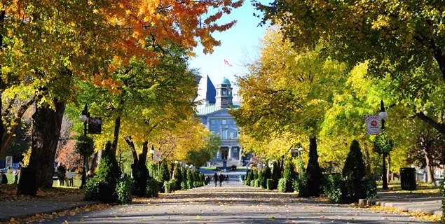
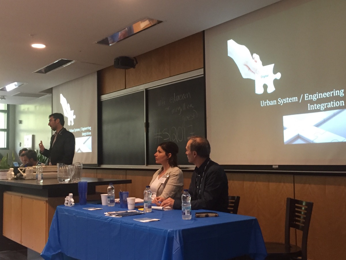
A panel introduces the idea of a smart city to students at Geothink’s 2017 Summer Institute at McGill University in Montreal, QC.

By Drew Bush

The term smart cities can mean one thing to a scholar of geomatics and something entirely different to an urban planner. The morning panelists on the first day of Geothink’s 2017 Summer Institute at McGill University in Montreal, QC enlightened more than 30 students and visitors on their perspectives.

The panel kicked off the main theme of this year’s gathering: “Smart City: Toward a Just City.” Each of the three days of the Summer Institute combined workshops, panel discussions and hands-on learning modules that culminated in a competition judged by Montreal city officials and tech entrepreneurs. The goal of the competition was for student groups to develop and assess the major principles guiding Montreal’s 2015-2017 Montréal Smart and Digital City Action Plan.

Discussion began with introductions by Geothink Head Renee Sieber, associate professor in McGill’s School of Environment and Department of Geography. Presentations were given by Stephane Guidoin, open data chief advisor in Montreal’s Smart and Digital City Office and Geothink Co-Applicants Stéphane Roche, associate professor in University Laval’s Department of Geomatics; Pamela Robinson, associate professor in Ryerson University’s School of Urban and Regional Planning; Rob Feick, associate professor in Waterloo University’s School of Planning; Teresa Scassa, Canada research chair in University of Ottawa’s Faculty of Law; and Victoria Fast, an assistant professor at University of Calgary’s Department of Geography.

“I work on the smart city and especially on the way digital technology, geospatial technology could improve the capability of citizens to be more engaged in cities,” Roche told students to begin the panel discussion. “And this is why for me, smart is really linked to citizen engagement.”

“Smart cities, for me, is based on four components,” he added. “The first one is digital, so that means the integration of engineering the urban systems, so it’s really about urban engineering and improving the efficiency of engineering structure for urban management. The second component is open, so a smart city means opening cooperation and participation. The third one is this idea of being able to give an answer for different issues based on the use of sensing, learning and sharing. This is the component where citizen engagement is really, really important. And the fourth one is this idea of urban innovation. A smart city is also really linked to this idea of innovation. Not only economical innovation but the way we build cities. And the way we build living space for people.”

Not all the panelists focused on citizen-engagement or new sensors being installed in cities. Robinson spoke on how urban planners talk about smart cities. She noted that the role of planners is to consider the public good and how this should be defined and protected in the development of smart cities in relation to issues of sustainability, equity and inclusion. Scassa noted that she teaches law and, therefore, she thinks of smart cities as sensor-laden cities that make much new data available. For her, this opens many new questions for governance processes and personal privacy.

Later in the day, Montreal City Council Chairman Harout Chitilian introduced students to the ways in which Montreal aims to blend open data, new tech and entrepreneurship to make Montreal a leader in smart cities. He spoke at the Institute even as outside McGill the city celebrated its 375th anniversary. In an interview afterwards, he offered a practical perspective on what being a smart city meant for Montreal residents.

“So first and foremost, you get accountability,” Chitilian said. “So you know where your tax dollars are going in terms of as far as the services are concerned. You know how your contracts are being managed as far as who it’s being given out to and what are the concentration of contracts in certain areas. And you also have accountability from your public safety/police forces that have now a transparent way of reporting a crime map from the city of Montreal.”

“And then now, bit-by-bit, on a service-by-service basis, you also have real-time data of the progress of the services that are delivered to you,” he added. “And we started with snow removal but there will be much more in years to come.”

After more in-depth presentations on civic engagement by Feick and Robinson, accessibility by Fast and free public Wi-Fi by Guidoin, the day transitioned into its first student activity. Groups were asked to answer three questions about McGill’s campus and enrolling as a student. The catch was that half the groups could use free campus Wi-Fi (which Chitilian had just announced as part of the city’s plan) and the other half could not use any online sources.

“I think it was a good chance to re-think about the internet that’s available in different places,” said Wonjun Cho, an undergraduate student at McGill. “I think it was personally easier to find many places using Internet and Wi-Fi. And, yeah, it would have been interesting if I had an experience in analogue as well to compare. But overall it was a lot of fun.”

As a resident of Montreal, Cho also felt strongly about the city’s move to install free public Wi-Fi.

“There are many tourists who visit Montreal every year,” Cho added. “And, especially international tourists, they often find a hard time to get place to place. And these days so many people use apps and Google maps and trip sites to find hotels. And it would definitely be an enhanced experience for visitors to Montreal. And also for people who live here because not many people have unlimited amounts of data on their cell phones.”

As the day drew to a close, students were led in a discussion by Sieber on what they knew about smart cities prior to their arrival and how the day’s events had changed their perspectives. In attendance were students of mixed disciplines ranging from geography and urban planning to law and geomatics.

“If you see what’s going on right now with the group work, getting students from different universities, from different parts of Canada—let’s face it from different disciplines—bringing together their own set of experiences and skills into a group learning situation, I think that’s a meaningful outcome as well,” Geothink Co-Applicant Jon Corbett, associate professor at University of British Columbia at Okanagan’s Department of Geography, said. “So I’m really happy to see how well the students seem to be getting on, how well they work together in small groups, and I think that, hopefully, will be laying the foundation for, you know, for future graduate students. So that when they go to conferences or, who knows, when they become academics, they will already have that relationship or those relationships in place.”

###

If you have thoughts or questions about the article, get in touch with Drew Bush, Geothink’s digital journalist, at drew.bush@mail.mcgill.ca.


Geothink Summer Institute On Smart Cities Convenes May 25, 2017

The 2017 Geothink Summer Institute on smart cities will convene May 25 to May 27 on McGill University’s downtown campus in Montreal, Quebec. (Image courtesy of http://jeannesauve.org)

By Drew Bush

As 22 Geothink students pack their bags and get ready for this year’s three-day 2017 Summer Institute “Smart Cities: Toward a Just City” their host city (and Geothink partner) will be preparing as well. This year’s Summer Institute will kick-off May 25 to May 27 in Montreal as celebrations for the municipalities 375th anniversary shift into high gear.

The timing couldn’t be more serendipitous: Strategic plans overseen by Montreal’s Smart and Digital City Office call for making the municipality a world renowned leader among smart cities by 2017. This year’s Summer Institute will bring together an interdisciplinary group of students and faculty—from law, geography, planning and more—to learn about issues facing smart cities and meet with key leaders in Montreal’s work toward becoming a leader in this field.

“It’s essential that students appreciate the ways in which smart technology can lead to fairer and just city-citizen interactions,” said Geothink Head Renee Sieber, associate professor in McGill University’s Department of Geography and School of Environment. “Students in this Summer Institute will learn about accessibility in smart cities, the promotion of social justice in this new environment and the integration of technology into city processes.”

Each of the three days of the Summer Institute will combine workshops, panel discussions and hands-on learning modules that will culminate in a competition judged by city officials. The goal of the competition will be for student groups to develop novel uses for Montreal’s open data to improve accessibility in the city.

The first day of the Institute will introduce the idea of smart cities during a panel discussion with Sieber and Geothink Co-Applicants Jon Corbett, associate professor in University of British Columbia at Okanagan’s Department of Geography; Stéphane Roche, associate professor in University Laval’s Department of Geomatics; Pamela Robinson, associate professor in Ryerson University’s School of Urban and Regional Planning; Rob Feick, associate professor in Waterloo University’s School of Planning; and Teresa Scassa, Canada Research Chair in University of Ottawa’s Faculty of Law. Later that day, students will be introduced to the problem they are trying to solve and hear from Montreal City Council Chairman, M. Harout Chitilian.

On day two, students will learn about legal issues relating to smart cities from Scassa, ethical considerations from Roche and social justice issues from Corbett. Multiple sessions throughout the day will also be devoted to group work on projects.

Finally, on day three, two separate talks will be headlined by Jean-Noé Landry, executive director of Open North, and Xavier Peich, a co-founder of Smarthalo. After time to work on project presentations, the day will conclude with the competition.

“Students will be exposed to smart city issues from a variety of perspectives, including government, non-profits, local tech entrepreneurs, planners and, of course, academia,” Geothink Student Coordinator Suthee Sangiambutt said. “This is going to be a fun event. Student attendees are from all sorts of disciplines and there will be a great opportunity to learn new skills and perspectives around smart city problems.”

The summer institute is hosted by Geothink, a five-year partnership grant awarded by the Canadian Social Sciences and Humanities Research Council (SSHRC) in 2012. The partnership includes researchers in different institutions across Canada, as well as partners in Canadian municipal governments, non-profits and the private sector. The expertise of the group is wide-ranging and includes aspects of social sciences as well as humanities such as geography, GIS/geospatial analysis, urban planning, communications, and law.

“We’re really fortunate to have such an interdisciplinary group of students who can unpack the term ‘smart’ from multiple angles to better understand both the challenges and opportunities that cities face today,” Geothink Project Manager Sonja Solomun said.

If you have thoughts or questions about the article, get in touch with Drew Bush, Geothink’s guest digital journalist, at drew.bush@mail.mcgill.ca.

Geothink Co-Applicant, Colleague and Friend Leaves Behind Rich Legacy of Empowering Sustainable Urban Change at the Community Level

Alexander Aylett's research

Alexander Aylett’s research examined how cities’ use of digital technology, citizen-sensors, and open data could allow local communities, government leaders and private businesses to manage urban areas more sustainable.

By Drew Bush

Geothink Co-Applicant Alexander C.E. Aylett passed away on July 23, 2016 from cancer.

Geothink Co-Applicant Alexander C.E. Aylett passed away on July 23, 2016 from cancer.

Geothink Co-Applicant Alexander C.E. Aylett passed away on July 23, 2016 from cancer. A beloved son, husband and father, colleagues also remember him for his warmth and passion. His research empowered urban communities to engage with sustainable development through the use of digital technologies and open data.

His wife Luna, their two daughters, Inara and Aurora, her father Richard and his wife Claire, and his two brothers, Chris and Andrew, survive him. A memorial service was held in his honor on Sunday, July 31st at the Alfred Dallaire Memorial Lounge located in Montreal, Quebec.

“It’s a real loss to the community of people who want smart cities to help improve sustainability and environmental issues,” Geothink Co-Applicant Pamela Robinson, associate professor in Ryerson University’s School of Urban and Regional Planning, said.

“Alex was trying to make these ideas stick between the [Massachusetts Institute of Technology] CoLab and through ÉcoHackMtl,” she added. “He really wanted to do research that mattered and that made a difference. And to try to bridge the gap between academy and practice. So he was pushing forward on new work.”

Aylett’s research interrogated how cities’ use of digital technology, citizen-sensors, and open data could allow local communities, government leaders and private businesses to manage urban areas more sustainable. One outcome driven by these new mediums for exchanging information has been an enhanced capacity of cities to use citizens and resources to strategically tackle issues such as climate change.

“Alex was a wonderful person—intense, caring, and insightful into how to derive practical political solutions to urban sustainability,” Geothink Head Renee Sieber, associate professor in McGill University’s Department of Geography and School of Environment, said. “He brought hackers, politicians, and environmentalists together to solve environmental and social problems through consensus and the pragmatic building of networks.”

Last February, Geothink spoke with Aylett about his work before writing an online article and podcast. We present previously unpublished excerpts of that audio interview here that capture the spirit of Aylett’s life and work. Find a written transcript at the end of this article.

Aylett joined the Institut national de la recherche scientifique (INRS) in July 2015 but had been actively pursuing research on these issues as a Banting Postdoctoral Fellow at MIT. Since 2009, he had published 12 papers with his most recent book chapter entitled “Relational Agency and the Local Governance of Climate Change: International Trends and an American Exemplar” in The Urban Climate Challenge: Re-thinking the Role of Cities in the Global Climate Regime (find a full citation at the end of this article).

He earned a master’s in comparative literature (2004) followed by a doctorate in human geography (2011) both from the University of British Columbia. At INRS, he was actively recruiting a new masters and doctoral student to join his research team. He firmly believed in partnership-based research, writing in his advertisements for students that “It makes for stronger research, and reduces the gap between research and action.”

His absence will also be deeply felt by the many communities where he led projects, particularly as the founder and co-director of ÉcoHackMtl.

“In a way, you could say his work already lives on by the fact the he was a part of a range of different stakeholders that were looking for ways to innovate using open data,” said Jean-Noé Landry, executive director of Open North. Landry collaborated closely with Aylett on several projects including ÉcoHackMtl and had supervised one of his graduate students at Open North.

“The values that bind us together are those that really kind of enable us to find strength in achieving our collective vision,” Landry added after describing values he shared with Aylett about open data and better governance. “And so, the fact is that we need to have leaders that step up, and put this stuff forward, and put in the time, and drive change. But we’re stronger when we’re empowering those around us.”

“That’s really at the core of the open data community. So, yes, we are losing a leader but I think his leadership was such that he was able to bring in more people to talk about the potential of data, to talk about potential innovation, to talk about the seriousness of urban sustainability issues and the potential of open data to resolve those issues. I think carrying that vision forward—obviously let’s not forget him. But we share the goals he advocated.”

Friends and family of Aylett have requested that instead of flowers, those wishing to show support may instead contribute to a fund to support the family’s immediate needs. Find it here: https://www.gofundme.com/2gbuq7w

Book Chapter Citation
Aylett, A. (2015) “Relational Agency and the Local Governance of Climate Change: International Trends and an American Exemplar.” in The Urban Climate Challenge: Re-thinking the Role of Cities in the Global Climate Regime. Eds. Craig Johnson, Noah Toly, Heike Schroeder. (Routledge). 12 pages.

TRANSCRIPT OF ORIGINAL AUDIO

[Geothink.ca theme music]

Alexander Aylett, I’m a professor of urban sustainability governance and innovation at the Center for Urbanization, Culture, and Society of the National Institute for Scientific Research or the proper French title is Institut National de la Recherche Scientifique in Montreal.”

“It’s really tricky to address a lot of the environmental impacts that are spread throughout the urban community. Right, sort of what people call collective action problems. And one of things that new technologies are very good at is building networked publics, right, coalitions of interest around—well I mean around all kinds of things. Around, you know, celebrity gossip and, you know, plastic surgery, you know, the biggest plastic surgery disasters. Ok, on the one hand fine. But also around much more meaningful stuff. Like green space. Like transit activism. Like creating community networks that are able to design and manage complex things. Like if you want to start talking about how you can manage a community energy transition, having good online platforms that are a tool that’s used in public mobilization and engagement strategies makes it possible to be more effective at the local level. But also then to scale up quite well from local action to action in other local areas either in the same city or in other cities.”

“I have a great example of that. There’s the 596-acres project. Do you know about it? It started in Brooklyn. And it’s a perfect example of how digital tools, open data and, then, a strong community mobilization that also works in the real world. Right this is not a 100 percent digital initiative. And I think that that’s why a lot of things fail. Is that they think that that digital is going to do all the work for them. But this is an example of how something can be very successful bridging digital and physical reality.”

“And what they do is that they have created an online map of all the vacant municipally owned land—well initially it started off in Brooklyn in New York City. And then a platform, sort of imagine a Facebook of sorts, which allowed people to say, ‘Oh yeah, I live around lot 77 at the corner of 5th and 22nd, and I’ve walked by that empty gravel lot my whole life. And I would love it if we could have a community garden there.’ And you post that. And then someone else who sees that lot and sees oh look someone else is already interested in doing a project here. ‘I wonder what it is?’ And they sign up too.”

“And so quite quickly you get clusters. You get networked group of local residents who might not know each other and who often don’t know each other otherwise that form online. But then meet in person and using data that they have taken from the New York City open data portal can identify which part of the municipality they need to contact if they want to propose a project—a citizen project to transform vacant land into a community asset. Whether it’s a park or a garden or, you know, some other maybe a market-space or that kind of thing.”

“And the stories that are coming out of that are interesting because they show that people will have walked past this space, some of them for 25 years, and always thought to themselves “ugh” we could do something so cool here if only I had some people to do it with me and I knew who I should contact if I wanted to get things done. And it’s another example of reducing barriers to action by providing access to just really key, strategic information.”

“So that’s what the open data does, that’s what the online portal does. It puts people in relationships with other neighbours but also with the city in a way that makes it possible to coordinate groups of people to start physically transforming their surroundings. And I think we’re going to see that same model applied to other tricky things.”

“Like if you’re trying to—well in Montreal for example—seven percent of our emissions, more or less, come from people who heat with fuel oil in their homes. And if you as an individual homeowner want to transition to electric heating or say geothermal or something more environmental, you can do that. But it’s a complex process. It’s expensive. And a lot of people begin the process of reflection and then decide not to just cause it’s all too daunting.”

“But in the same kind of way you could use data on energy consumption in neighbourhoods. Create a platform where residents who are all interested in shifting their homes onto a more sustainable fuel source could create groups and then collectively do a call for proposals. So that they could bid—so the companies could bid not on just one home but one 20 homes, for example, which would bring down the costs, which would simplify the process. And it would mean that instead of doing homes on a sort of a piecemeal fashion, you would be doing them on a community-by-community basis. And shifting the whole energy systems of a community.”

“And could you do that without the technology? Well, yeah, sure. You could have a leafleting campaign and you could have community volunteers that go out and knock on doors. And, actually, you’re probably still going to need all those things. But the adding on of layers of data and of cartography and of a good online interface and all that, I think just empowers people to do all that work more effectively and, then critically, for people elsewhere in the city to see what’s happening. And to understand how they can do something similar in their neighbourhood. And that’s traditionally sort of the Achilles heal of local action—which is that it’s hyper-local.”

“But new digital technologies give great local ideas legs by creating tools that are easily shareable and by creating inspiring examples that can travel. That can travel 10 blocks away or that can travel, you know, 100 km away, or can travel to the other side of the country. And so I think that example of effective local action and the speed at which things can travel and scale up is another exciting facet of the new technologies that we are seeing.”

[Geothink.ca theme music]

[Voice over: Geothoughts are brought to you by Geothink.ca and generous funding from Canada’s Social Sciences and Humanities Research Council.]

###

If you have thoughts or questions about this article, get in touch with Drew Bush, Geothink’s digital journalist, at drew.bush@mail.mcgill.ca.

Geothoughts 12: Can A Game Improve Regional and Urban Planning Processes?

A Minecraft version of Toronto’s CN Tower.

By Drew Bush

We’re very excited to present you with our 12th episode of Geothoughts. You can also subscribe to this Podcast by finding it on iTunes.

In this episode, we take a look at two Geothink researchers who are investigating how the popular video game Minecraft can be used to improve local and regional planning processes. In particular, we talk with Ryerson University Gold Medal award winner Lisa Ward Mathers, and Ryerson master’s student Jacky Li. Both have worked with Geothink Co-Applicant Pamela Robinson, associate dean in Ryerson University’s School of Urban and Regional Planning.

Thanks for tuning in. And we hope you subscribe with us at Geothoughts on iTunes. A transcript of this original audio podcast follows.

TRANSCRIPT OF AUDIO PODCAST

Welcome to Geothoughts. I’m Drew Bush.

[Geothink.ca theme music]

“We also wanted to build, how do you say, just an open web kind of thing where you can log on and start building away at the city of Toronto. So the vision was to have all of Toronto built in Minecraft and that’s where I came in. I tried to—they hired me to get the program up and going. But I didn’t know how to start. So my research basically consisted of how we would do something like this.”

That’s Ryerson University Master’s Student Jacky Li talking about his work with Minecraft. Li is a student with Geothink Co-Applicant Pamela Robinson, associate dean in Ryerson University’s School of Urban and Regional Planning. Last summer, he interned with the City of Toronto’s Office of the Chief Planner.

Minecraft isn’t so much a game but rather a destination, a technical tool, and a cultural scene all rolled into one program. Children who use it can engineer complex machines; model the world in cube-like form; shoot and post YouTube videos of their work; and setup servers where they can hang out with their friends. The software, initially launched by Mojang (a Swedish game studio) in 2009, now boasts more than 100 million users. Microsoft recently bought it and Mojang for a record $2.5 billion.

“So I looked at examples of, in Sweden, they had really good one with between the architects and the government where they just focused on a suburb and they had users go in and start building. And then last summer, the graduating class of Niagara College [in Welland, Ontario] translated some GIS data into Minecraft. And I contacted them and they taught me how to do it.”

“Yeah so, at the end of it what I made for the city of Toronto was a report that said how to build like the sub-server thing, how to host it, and some potential programming they can do with children such as like a floor area ratio exercise where you can imagine density. So if you’re given solar power, how many blocks can you build different kinds of built forms depending on the criteria of the exercise . Yeah and just stuff like that.”

Li grew up as part of the Minecraft generation. For him, “It’s just a popular computer game where you basically craft things. It’s kind of like Lego, but on your computer, or on your Xbox or PlayStation, or on your mobile phone.”

His work was inspired by another student at Ryerson who wrote a report for the City of Toronto on the educational potential of a tool such as Minecraft that engages students with sometimes complex computer science in an immersive environment. Li is not alone in Geothink as a researcher working to determine how Minecraft can empower communities in urban planning decisions.

“From there I asked them specifically about different contexts within which Minecraft could potentially be used. Different scales, like for instance, a committee of adjustment or, you know, larger scales from there like an official plan review. I’m sort of asking what do you think, would this work in this context. What are your sort of initial impressions?”

That’s Lisa Ward Mather on her master’s research project she completed in 2014 at Ryerson University also with Robinson. She’s describing her work interviewing 12 planning officials to determine the usefulness of Minecraft for those working in regional and local urban planning.

In 2014, she graduated as the recipient of the Ryerson Gold Medal for her thesis work that was cited for combining academic proficiency with community engagement in a meaningful way.

“It wasn’t an interview with Minecraft experts by any means. A few of my respondents had encountered the game in a very, you know, not very intensive setting. I mean no one had really sat down and played extensively. But luckily Minecraft is a not a terribly difficult thing to explain to someone, especially with visuals. And I was able to get some really interesting observations from the people I spoke to.”

Her project interrogated whether planners felt open to using Minecraft and whether they thought it would engage the public. She also asked what possible benefits and obstacles they foresaw in specific applications. Her findings largely showed that it could be a useful tool for engaging the public in planning decisions, but obstacles such as it’s cost as well as the cost of equipment needed to support it could limit use.

Mather’s work did not stop after her graduation.

“I was in communication with a staff member from the office of the chief planner at the city of Toronto. And they, as you know, they are interested in trying new tools and using new tools in different ways, and engaging people in ways maybe they’re not used to being engaged. And so they were interested in seeing what could be done with the game.

“So, we, after some discussion, concluded that one possibility would be to have them send me some SketchUp files, Google SketchUp files, of a corridor in Toronto. And to produce a Minecraft world that had both what that corridor looks like right now, what it would like in the near future when there are more mid-rise buildings lining the sides of the streets, and then the in the far future when the entire corridor is lined with mid-rise buildings. So, I, after a fair amount of experimentation, and, uh, and this is something I had never done before. So I looked at what various tools that were available online and I was able to produce those three models within the same Minecraft world.”

“And I built a little rail car down the middle of the street so that the user rode from the present to the near future and then to the far future. And I made a movie of that which then they played at an event that they were holding from the Office of the Chief Planner.”

This small project has opened interesting possibilities for the City of Toronto to engage citizens with a unique tool like Minecraft. From Sweden to Canada, the Minecraft generation may one-day grow up to design the cities of the future.

[Geothink.ca theme music]

[Voice over: Geothoughts are brought to you by Geothink.ca and generous funding from Canada’s Social Sciences and Humanities Research Council.]

###

If you have thoughts or questions about this podcast, get in touch with Drew Bush, Geothink’s digital journalist, at drew.bush@mail.mcgill.ca.


Paper Spotlight: Examining Urban Reasoning Skills in the Age of Digital Cities

Smart citizens

Smart citizens of the future must develop the skillsets required to understand spatio-temporal interactions in dynamically linked urban networks of places according to Geothink Co-Applicant Stéphane Roche (Photo courtesy of http://www.i2cat.net/sites/default/files/smart-city.jpg).

By Drew Bush

In a paper published this past May, Geothink Co-Applicant Stéphane Roche posits that emerging smart cities require citizens to develop an urban intelligence that meshes material realities with digital information. In order to fully manage and engage with urban spaces, future smart citizens must develop the skillset required to understand spatio-temporal interactions in dynamically linked urban networks of places.

Stéphane Roche is a professor and vice dean of research for the Faculty of Forestry, Geography, and Geomatics at the University of Laval (Photo courtesy of www.scg.ulaval.ca).

Entitled Geographic information science III: Spatial thinking, interfaces and algorithmic urban places-Toward smart cities, the paper was published in Progress in Human Geography. Roche, a professor and vice dean of research for the Faculty of Forestry, Geography, and Geomatics at the University of Laval, has previously written two papers on the subject. The series of papers defines urban intelligence, the importance of spatial reasoning in smart cities, and the organization of digitally enabled cities.

“Most of the resources that are today available in order to help people to move in the city, are available—are digitally available,” Roche said. “[Yet] at the same time, mobility in the city is really grounded in the materiality. If you need to walk or if you need to take your bike, it’s an active kind of mobility. And if you don’t really know perfectly the places where you need to travel, you need to have the minimum capability to access information from different kinds of interfaces. Through your phone, through the Internet, through a different kind of display available in the city for example.”

Transportation presents but one case study for examining the integration of digital technology into physical urban places. Roche expands on this interaction to further define place as consisting of three elements: 1) A geographical location; 2) An event (such as an accident, festival, or meeting); and 3) A name. This, of course, means that two separate places could involve the same physical space but at different times.

As you may imagine, this type of insight takes time to develop. After reflecting on the existing literature in the field, along with his own previous work, Roche begins his first paper, Geographic Information Science I: Why does a smart city need to be spatially enabled? by emphasizing the importance of Geographic Information Science (GIS) to smart cities. He argues that the smart city is first and foremost a spatially enabled city.

His second paper, Geographic information science II: Less space, more places in smart cities, Roche advances the idea that modern cities consist of networks of connecting places, amends the very definition of place, and posits urban intelligence as the capability to understand how urban places are created and how they interact. Finally, his most recent third paper comes full circle to question why people who have developed urban intelligence necessarily also employ spatial learning and reasoning skills.

“Actually, what I’ve tried to do in this report is probably link what I define as the urban intelligence,” he said. “That means the capability of someone, people, or a group to understand the urban dynamic by using spatial skills and spatial thinking abilities. That means making the link between different components of the urban environment. So this is what I define as the urban intelligence. The capability of understanding what’s happened at the specific time and specific place.”

“The aim, ok, is to say in our current modern environment, there are multiple opportunities and tools and approaches that could help humans to improve their spatial thinking ability,” he added. “And these improvements will be more and more required if people want to engage. That means they will, there is no way to keep them engaged without spatial thinking abilities in this kind of new urban environment where everything is connected. Where everything is based on dynamic fluxes and mobilities. So if you are not able to understand how those dynamics work, you will have more and more difficulty in getting grounded in the place where you live.”

Please find links and abstracts to each paper mentioned in this article below:

Abstract 1
Geographic Information Science I: Why does a smart city need to be spatially enabled?
In this report I propose to examine the concept of the ‘smart city’ from the standpoint of spatial enablement. I analyse emerging research on smart cities, particularly those addressing the potential role of GISciences in the development and implementation of the concept of smart cities. I develop the idea that the intelligence of a city should be measured by its ability to produce favourable conditions to get urban operators (citizens, organizations, private companies, etc.) actively involved into sociospatial innovation dynamics. To obtain such a commitment, I believe that operators should be able to develop and mobilize (digital) spatial skills so that they could efficiently manage their spatiality. In other words, I argue that a smart city is first of all a spatially enabled city.

Abstract 2
Geographic information science II: Less space, more places in smart cities
This second report is dedicated to the concept of ‘place’ revisited in the context of smart cities. Some recent studies suggest that today’s digital cities rely more on an approach to the urban context based on a network of connected places than on an approach to the city built on areal spaces. Does it mean that there are more places and fewer spaces in spatially enabled cities? Is the intelligence of a city mainly related to its ability to sound out the genesis of urban places? These issues raise questions about the design of spatial models used to build GIS, as well as place-based urban design methods and tools. This second report explores these questions from the standpoint of GISciences.

Abstract 3
Geographic information science III: Spatial thinking, interfaces and algorithmic urban places—Toward smart cities
This third report examines interfaces as a key element enabling spatial skills, and development of new forms of digital spatialities for smart cities. Digital technology is becoming consubstantial to urban materiality, but map interfaces are particularly central tools for indexing (geographic) knowledge and expertise, accessing informational components of digital cities, and actively engaging digital dimensions of urban places.

If you have thoughts or questions about the article, get in touch with Drew Bush, Geothink’s digital journalist, at drew.bush@mail.mcgill.ca.

Minecraft to Educate Youth and Plan Better Cities

maxresdefault

Minecraft users envisioned the City of Stockholm in Sweden the way they wanted it to be using the popular game.

By Drew Bush

When the New York Times recently ran a ten page magazine story on The Minecraft Generation, it focused primarily on young users learning basics of computer science through their engagement with this software. For two Geothink researchers, harnessing youth enthusiasm for this tool is also central to helping cities make better planning decisions.

For the un-initiated, Minecraft isn’t so much a game but rather a destination, a technical tool, and a cultural scene all rolled into one program. Children who use it can engineer complex machines, model the world in cube-like form, shoot and post YouTube videos of their work, and setup servers to hang out on with their friends.

The software launched by Mojang (a Swedish game studio) in 2009 now boasts more than 100 million users. Microsoft recently bought it and Mojang for a record $2.5 billion.

Lisa Ward Mather studied Minecraft’s possible application to urban planning as a master’s student with Geothink Co-Applicant Pamela Robinson, associate dean in Ryerson University’s School of Urban and Regional Planning. In 2014, she was recognized for community engagement in her thesis work with a Ryerson Gold Medal.

“It was basically an exploratory study, sort of, where I went and spoke to planners and engagement specialists and asked them to what degree and in what context they thought that Minecraft could be a useful tool for planners to use for engagement,” she said. “I interviewed twelve people and came up with some really rich responses, actually.”

Many of the experts she spoke with during her master’s research project were senior-level and had not necessarily had much, if any, experience actually working with the Minecraft program. To ensure they adequately understood the software, Mather created a video that explained the game, what it looked like and the various activities users could undertake. The video also featured unique projects.

“Such as something called Blockholm,” Mather said. “Which was, in the city of Stockholm, they brought in infrastructure related to Minecraft. And then they allowed or gave away plots of land within the Minecraft city for people to build what they thought the city should be. It was a project that was sort of a visioning project. And they ended up building things in real life and having a museum exhibit that people could wander around in.”

Educating Young Students in the Virtual Minecraft City of Toronto
Mather is not alone in researching the power of Minecraft to empower communities in urban planning decisions that can affect their daily lives. For an internship at the chief planner’s office with the City of Toronto, another one of Robinson’s students, Jacky Li, helped the city initiate an educational program that envisions the entire city built in Minecraft.

A master’s student from the University of Ryerson had written a report on how using Minecraft might be effective as an educational and planning tool for work with young children. For his own work during the summer of 2015, Li assessed the technical challenges the city would need to overcome to engage students in the school system in envisioning complete communities through Minecraft.

He describes the software as a “popular computer game where you basically craft things.” It’s analogous to “Lego,” he said, “but on your computer, or on your Xbox or PlayStation, or on your mobile phone.”

Li examined examples in Sweden of architects and city planners collaborating to better design a suburb and learned from users at Niagara College in Welland, Ontario how to translate GIS data into the program.

“At the end of it what I made for the city of Toronto was a report that said how to build like the sub-server, how to host it, and some potential programming they can do with children,” Li said. “Like a floor-area ratio exercise where you can imagine density. So if you’re given solar power, how many blocks can you build different kinds of built forms on depending on the criteria [of the power].”

Find a sample of the report Li wrote here.

The Minecraft Generation Becomes Today’s City Planners
Minecraft not only engages users with its simple design in educational settings but also in envisioning how to plan for future changes in a city. Both Mather and Li ask practical questions about the utility of a program like Minecraft beyond its entertainment value.

Mather’s master’s set the stage by asking planners about the obstacles and benefits to Minecraft to determine contexts in which such software might be useful. Since the conclusion of this work, she’s also found interest in her work from the chief planner’s office at the City of Toronto.

In a recent project she tested her own skills with Minecraft—something she had not done previously. The city sent her Google SketchUp files of a corridor in Toronto that she used to produce a Minecraft world. In particular, she created a 3-D model of what the corridor looked like now, in the near future with more mid-rise buildings and in the far future when it’s lined with such buildings.

“It was not a detailed world in the sense that the building didn’t have windows and stuff like that,” she said. “Because it was just a model that came from Sketchup, it was not a very detailed, the file I brought in was not, did not have that kind of nuance to it. Of course, bringing, the complexity of bringing something into Minecraft is you can’t necessarily determine the kind of material it’s made out of. Every individual part of the building would be the same material. So I ended up with a stone world, of the corridor and surrounding buildings.”

Even so, she found this small project very interesting and hopes to continue the work. Such research embraces the potential of new media in improving urban planning decisions. (For more, see our story on using open data to revolutionize urban planning decisions.)

If you have thoughts or questions about this article, get in touch with Drew Bush, Geothink’s digital journalist, at drew.bush@mail.mcgill.ca.


Gethoughts 8: How Technology is Reshaping Citizen Interactions on Climate Change

pic32-e1435343808697

Hydro Quebec is setting up a new circuit of public electric charging stations, one of many changes in the works as cities across Canada prepare for more environmentally friendly futures.

By Drew Bush

We’re very excited to present you with our eighth episode of Geothoughts. You can also subscribe to this Podcast by finding it on iTunes.

In this episode, we examine what role Canada’s cities play in international solutions to climate change as well as how new technologies shape interactions in neighbourhoods and between neighbours on environmental issues. In it, we talk with Geothink researcher Alexander Aylett, a professor and researcher at the Institut national de la recherche scientifique.

Thanks for tuning in. And we hope you subscribe with us at Geothoughts on iTunes. A transcript of this original audio podcast follows.

TRANSCRIPT OF AUDIO PODCAST

Welcome to Geothoughts. I’m Drew Bush.

[Geothink.ca theme music]

Last week on Geothink.ca, we brought you a look at how open data and digital technology are reshaping the way cities plan for sustainable futures and how to act on issues such as climate change. Today we dive deeper into the changes taking place locally and internationally on this topic.

“One of the things I’m most excited about here in Montreal, is electrification of mobility in the city. So something in the order of 40 percent of Montreal’s GHG emissions come from moving people and things around in the city. Trucks, cars, trains—to a certain extent—all of those things. And what we’re seeing now is a real scaling up of, I guess, work that’s been happening over the past four or five years to electrify as much of that as we can.”

That’s the opinion of one expert who has been studying these issues from his office in Montreal, Quebec. We spoke with him over Skype this month.

“Alexander Aylett, I’m a professor of urban sustainability governance and innovation at the Center for Urbanization, Culture, and Society of the National Institute for Scientific Research or the proper French title is Institut National de la Recherche Scientifique in Montreal.”

Aylett believes the time has come for changes that make transit, buildings, and energy more efficient in cities. That’s because cities can play an outsized role in confronting the important environmental issues of today by mixing a curious blend of new technology, empowered citizen groups, and long-term planning. The first signs heralding these changes are here.

“So we have Hydro Quebec that’s setting up la route verte où route bleu of publicly accessible charging points. And it started of with like two, three, four, five and you know now we’re aiming for a few thousand in the city within the next couple of years. And we’re seeing the launch of things like Téo taxi, where there is going to be, their plan, is—if I’m right about their deadlines—by next December is to have something like 2,000 new electric vehicles on the roads of Montreal. So a big private player dramatically increasing the number of electric vehicles that we’ve got on the roads. Similar action happening in big players like CommunAuto.” 

Such changes are not purely financial. Cultural shifts have occurred before in Montreal. Not long ago when the city began planning for the introduction of Bixi bike sharing, they didn’t tinker around the margins. Instead they created many more bike paths that were safer for riders and that have since been adopted by many residents. On environmental issues like climate change a similar transition may soon take place.

“We’ll see gas burning vehicles sort of being retired. New institutional players like taxis, for example, buying electric. Private citizens buying electric. But also private citizens realizing that the increased convenience of smart taxi services like Uber, and Téo, and Car-to-go, and other car sharing networks means that people don’t need to have a private vehicle in a lot of cases anymore. People who are sort of on the borderline zone of needing a car regularly but not every morning for their commute I think will be in a position to just abandon the private automobile in favor of convenient access to different mobility providers.”

Such changes would bode well for those who would see Canada reduce greenhouse gas emissions or GHGs. More cooperation is needed between actions taken by cities and those being coordinated on national and international levels. The 2015 Paris Agreement and the prominent role of cities in it means such a future is not just possible but likely, according to Aylett.

“Coming out of COP21 what we have is a much more open understanding of the fact that cities are a critical partner for states, provinces, and national governments. And I think—and this is why it’s such an exciting period right now, like particularly this next sort of six months—I think that we what we should be seeing is more effective partnerships between those different players. More funding coming down especially in Canada given the commitments our government has to fund urban infrastructure projects…Spreading from city to city to city effective interventions into different aspects of our urban environmental footprints. That’s fantastic.”

In a future where cities help solve climate change, different cities will each contribute a piece of the solution. In Montreal it may be innovations in transport technology and the manner in which individuals book transit, Vancouver may continue leading in green building efforts that incorporate “reach codes” so each step in efficiency serves to enhance the next, and Toronto may utilize new models and data to better plan where to locate parks and green roofs.

Some technological changes will undoubtedly allow citizens to contribute their expertise and opinions to solutions while others will focus on overcoming small barriers in daily life that could have a dramatic impact on environmental issues such as climate change.

“Basically we’re talking about reducing friction and reducing barriers to use where the simplicity of jumping into your car, and driving somewhere—even if in the end it creates congestion, it’s an un-enjoyable experience—it’s almost a knee-jerk reaction for some people because it’s so simple. And the public transit in some situations is more complex because you need to transfer, you need to use, maybe you need to use Bixi and the Metro and the bus. Things that are when you look at it seems more complicated. But having an interface like Transit App that just lays it all out for you means that from a user point of view, it reduces the barrier to switching from one type of behavior—driving in your car—to another type of behavior—which is getting there by any other, you know, means of mobility.”

“And the next phase of that, and this is something that we’re seeing already being considered in some places, like Singapore for example, is just to stop charging people for individual modes of transportation and start charging people for reaching their destination. And so the difference would be you open up your app, for example, and say, ‘I’m here and I need to get there.’ And the application uses smart open data about different modes of transportation to calculate for you a couple of different routes and charges you for the route. And so you just pay to get from your house to school or from your house to work or from your house to the art gallery.”

But that’s not all. New information technologies and open data platforms have a habit of helping citizens to organize to solve problems. Environmental issues like climate change are no different once the right data sets and support are in place.

“If you wanted to start talking about how you can manage a community energy transition, having good online platforms that are a tool that’s used in public mobilization and engagement strategies makes it possible to be more effective at the local level but also then to scale up quite well from local action to action in other local areas either in the same city or other cities.”

Aylett believes that such networked communities can bring together individuals who may have never known each other on topics of mutual concern. Such collaborative work can lead to a snowballing effect where changes to how cities respond to environmental issues might some day become inevitable.

[Geothink.ca theme music]

[Voice over: Geothoughts are brought to you by Geothink.ca and generous funding from Canada’s Social Sciences and Humanities Research Council.]

###

If you have thoughts or questions about this podcast, get in touch with Drew Bush, Geothink’s digital journalist, at drew.bush@mail.mcgill.ca.


Four Geothink Partner Cities Named to Top 10 on First Ever Canada Open Cities Index

Rankings of Canada's Top 10 cities out of possible max scores of 193 (Image courtesy of Public Sector Digest).

Rankings of Canada’s Top 10 cities out of possible max scores of 193 in Public Sector Digest’s 2015 Open Cities Index (Image courtesy of Public Sector Digest).

By Drew Bush

Numerous city, state, and provincial governments across North America are finding new ways to share government data online. With more than 60 nations now part of the Open Government Partnership, it’s often difficult to determine which initiatives are simply part of a growing fad instead of being true attempts at more responsive and accountable government.

In the United States, President Barak Obama announced plans in 2009 to make many federal agencies open by default with government information, yet just last month the office charged with carrying out this directive failed to openly publish a schedule for its guidelines on this work. In Canada, a variety of city initiatives aim to allow citizens to more easily view crime statistics, find out information about neighborhood quality of life, or time the arrival of the next bus. With so many initiatives, it can be difficult to determine which best improves municipal responsiveness or offers new services to citizens particularly amidst promises by the newly elected Liberal government on open data (see Tweet below).

The authors of Public Sector Digest’s first ever 2015 Open Cities Index aim to solve this problem by providing “a reference point for the performance” of open data programs in 34 Canadian cities. The authors of the index undertook a survey to measure 107 variables related to open data programs. In particular, the index measures three types of data sets cities may have made available: those related to accountability (e.g. elections or budget data), innovation (e.g. traffic volume or service requests), and social policy (e.g. crime rates or health performance).

Across each data set in these three categories, municipalities were scored on five variables according to questions such as whether their data sets are available online, machine readable, free, and up-to-date. The aim was to help these municipalities, which often have limited resources to spend on open data programs, to assess their strengths and weaknesses and improve open data programs.

Four Geothink partner cities made the top 10 of the index, with Edmonton in first place, Toronto second, Ottawa fourth, and Vancouver sixth. At last year’s Canadian Open Data Summit, Edmonton also won the Canadian Open Data Award. You can find the full list of city rankings on the report’s home page. Yet the value of these types of ratings and awards will only be shown over time, according to many practitioners in the field.

“It’s hard to tell what it means to be ranked fourth because it’s a brand new thing,” said Robert Giggey, the coordinator and lead for the City of Ottawa’s Open Data program. “It’s not something that’s done every year, every month, that everybody knows about and is waiting for. So it’s kind of yet to be determined.”

The Value of the Index

Other indexes have measured open data at the national level, such as the Open Data Barometer. And measurements of municipal open data undertaken by two university students focused only on what types of data sets were available. The Open Cities Index works to take this a step further by engaging with key areas of interest. In particular, the index aims to standardize measurements around three themes:

1. Readiness—To what extent is the municipality ready/capable of fostering positive outcomes through its open data initiative?
2. Implementation—To what extent has the city fulfilled its open data goals and ultimately, what data has it posted online?
3. Impact—To what extent has the posted information been used, what benefits has the city accrued as a result of its open data program, and to what extent is the city capable of measuring the impact?

One Geothink researcher cautions, however, that it’s difficult to ascertain the worth of the index until its authors make the full report available along with more information on the 107 variables surveyed. In particular, he said, implementation can be a difficult metric to measure because different cities have different data collection responsibilities and different goals.

“I’m working on some research right now that shows that governments don’t actually have very good tracking metrics for use,” Peter Johnson, assistant professor in the Department of Geography and Environmental Management at the University of Waterloo, wrote in an e-mail to Geothink.ca. “Much of their sense of who uses open data and what it is used for is anecdotal and certainly incomplete. Since open data is provided with few restrictions, it is difficult to track who is using it and what it is being used for in any comprehensive way.”

Beyond the data online now, cities interested in being included in future years of the index and accessing a detailed analysis of municipal open data programs across Canada must contact Public Sector Digest. Some municipalities, like Ottawa, may wait and see how it goes in those places that have already paid for the service, according to Giggey.

“I want to see what the reaction is from the open data community, from other jurisdictions, from other areas—Geothink—about what they think of the index,” he said. “Is this any good? Is it worth anything? Then we’ll look to see if it’s something we want to invest in.”

A screen shot of Toronto's Open Data portal for city hall.

A screen shot of Toronto’s Open Data portal for city hall.

The Reaction Among Geothink Partner Cities

The value of the index will be determined as more details on its methodology and conclusions are released, and, perhaps, it becomes a regular measure of open data work in Canada’s municipalities. For now city staff in charge of open data work in the cities interviewed by Geothink.ca agree that the index does achieve the goal of bringing recognition to the work they are doing. In Ottawa, this has included work to make the city accountable by providing datasets on elected officials, budget data, lobbyist and employee information, and 311 calls. Toronto got a relatively early start with city budgets in 2009 and now also has a portal with social data on neighborhoods (including datasets like demographics, public health, and crime rates).

“I am glad the index recognizes the time and effort each city puts in to make its data open and accessible for reuse and repurpose,” Linda Low, open data coordinator for the City of Vancouver, wrote in an e-mail. Datasets in her city include information on crime, business licenses, property tax, Orthophoto imagery, and census local areal profiles. “This doesn’t happen overnight and it certainly is a team effort to get to where we are today.”

Edmonton’s recognition for its work derives from a 2010 decision by city leaders to launch an open data catalogue and the 2011 awarding of a $400,000 IBM Smart Cities Challenge award grant. Work in the city has included using advanced analysis of open data streams to enhance crime enforcement and prevention, an “open lab” to provide new products that improve citizen interactions with government, and interactive neighbourhood maps that will help Edmontonians locate and examine waste disposal services, recreational centres, transit information, and capital projects. More can be found on Edmonton’s work in a previous Geothink article.

“We are thrilled and honoured that our innovation and hard work have been recognized,” Yvonne Chen, a strategic planner for the City of Edmonton, wrote in an e-mail. She noted that Edmonton’s success, which results directly from a city council policy on open data, includes having an online budget tool that increases transparency about the allocation of public funds. “Our goal has always been to be a leader in the Canadian open government movement.”

While the recognition helps bring attention to the work being done by cities, much remains to be seen about how well the index actually compares cities against each other when objectives and the types of data recorded can vary greatly.

“It’s great to be in the top 10 any time, but we know from when we got the survey sent to us, we weren’t sure of all their measures that they were taking,” Keith McDonald, open data lead for the City of Toronto, said.

“We’d like to see other studies and maybe a little more apples to apples comparison for sure,” he added. “I think actually that was the intent—I can’t speak for the Public Sector Digest—but I think that was the intent of having an ongoing group that would buy into their measuring, so that people could continue to tweak and make it a stronger real apples to apples comparison. And we would support that.”

In fact, the value of an index like this one may lie in allowing cities to track their own progress over time.

“For all those cities included (and even those that aren’t) it can help to narrow the field as to where effort may be best placed to improve open data provision,” Johnson wrote of what he called a “high-profile external evaluation” of each city’s work.

If you have thoughts or questions about this article, get in touch with Drew Bush, Geothink’s digital journalist, at drew.bush@mail.mcgill.ca.