Tag Archives: Geothink

Geothoughts 10: Governing Makerspaces in Toronto with Jordan Bowden

A McGill University undergraduate has undertaken unique research on the governance of Toronto’s Makerspaces.

By Drew Bush

We’re very excited to present you with our tenth episode of Geothoughts. You can also subscribe to this Podcast by finding it on iTunes.

In this episode, we examine a project funded by McGill University Arts Undergraduate Research Internship Award (ARIA) and Geothink. In it, one student has found a huge variance between the types of Makerspaces found in Toronto. The city’s groups represent what McGill University Undergraduate Jordan Bowden calls a unique Canadian evolution of the Makerspace concept. He worked with Geothink Head Renee Sieber, associate professor in McGill University’s Department of Geography and School of Environment.

A Makerspace is a place where people come together and share commonly owned tools, equipment, or software to learn new skills. They can be for profit, they can be non-profit, they can be run by a group of individuals, or by larger institutions like universities or libraries. First popular in China and other Asian countries, these do-it-yourself (DIY) spaces where people can gather to create, invent, and learn have also spread to the United States and, more recently, Canada. Many of Canada’s Makerspaces face little formal regulation and differ greatly from their formulations than in other countries.

Thanks for tuning in. And we hope you subscribe with us at Geothoughts on iTunes. A transcript of this original audio podcast follows.

TRANSCRIPT OF AUDIO PODCAST

Welcome to Geothoughts. I’m Drew Bush.

[Geothink.ca theme music]

“So Makerspaces, there are a lot of different terms that have sort of been in the same sphere as Makerspaces, ranging from Hackerspaces to Hacklabs to Fablabs to even some shared studio spaces which are less formal. All of kind have been put underneath the umbrella term of a Makerspace. And a Makerspace basically is a place where people come together and use commonly owned tools.”

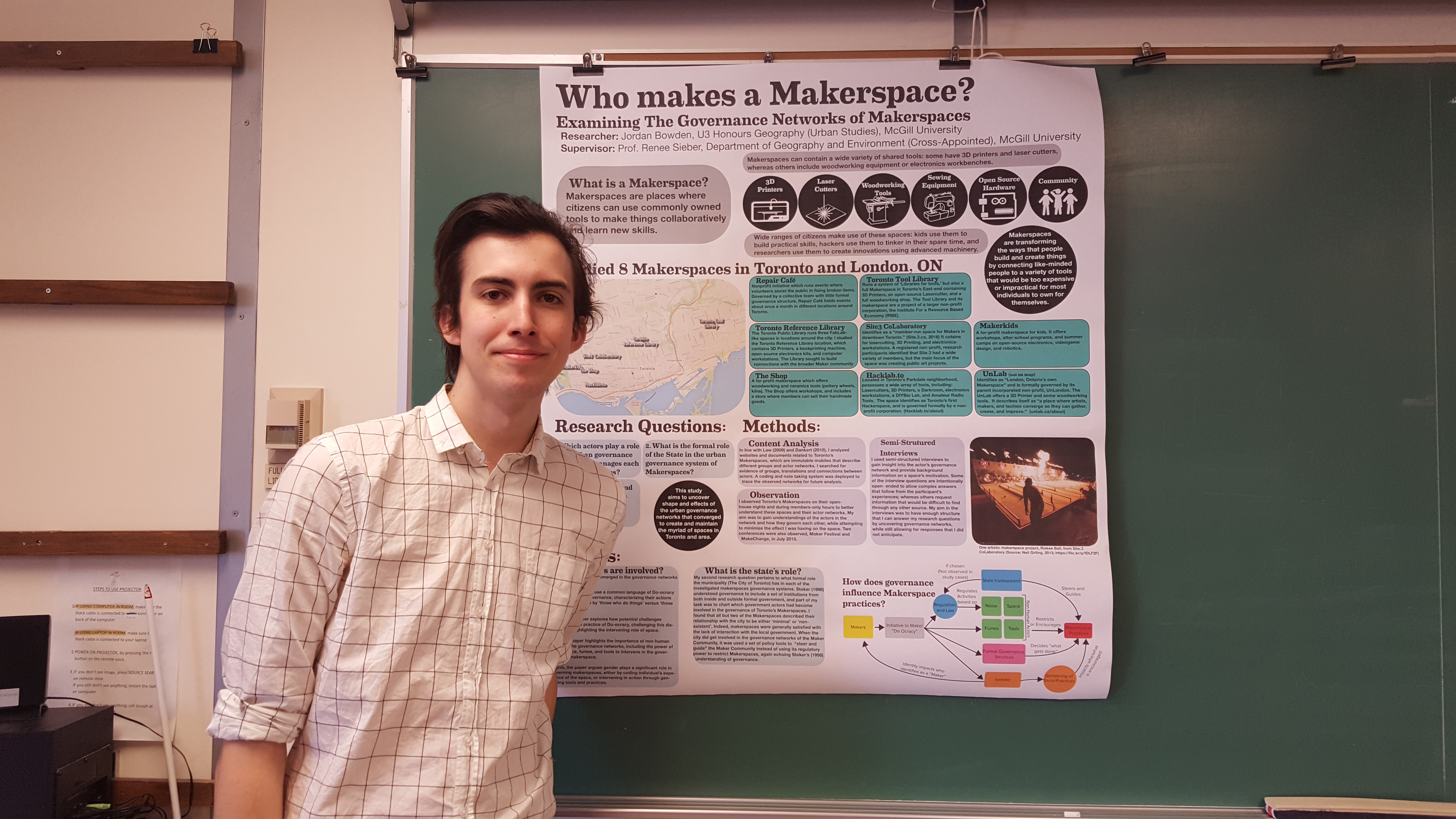
That’s McGill University Undergraduate Jordan Bowden on his unique yearlong honours thesis project investigating how governance works in 10 different Toronto Makerspaces. He’s a long-time participant in the work being done in Makerspaces. He also recently completed his thesis for Geothink Head Renee Sieber, associate professor in McGill University’s Department of Geography and School of Environment.

“They can be for profit, they can be non-profit, they can be run by a group of individuals, or by larger institutions like universities or libraries. So in my research, I find that there is a huge variance of the practices between spaces that were using this term. Especially in Toronto which is where my research is focused. There was, there was just a huge variety of Makerspaces. I studied about 10 Makerspaces in my research. And some of them are run just groups of artists who are using commonly owned tools. Others were run by the local library and really focused on sort of entrepreneurship and that sort of thing.”

Still confused about how to define a Makerspace? You might not be alone, as the concept has varied and evolved as it has spread globally.

“So, yeah, I mean the term itself has only really emerged over the past four to five years I’d say. And before then, like Hackerspaces and Hacklabs, have like that term itself has a much longer history stretching all the way back to the 1990s. The main distinction there is that Hacklabs and Hackerspaces are often focused more on computers. Whereas Makerspaces can be focused really on any sort of production be it computers or woodworking or metalworking and that sort of thing.”

Bowden says that the question of how such spaces are governed in Canada is an entirely new one. And he adds that it’s crucial: What Makerspaces can actually do is greatly affected by how they are run.

“Within each Makerspace, some Makerspaces have sort of formal committees wherein makers are actually involved in the running of the space in every aspect. Whereas others are pretty much governed by a handful of people. Be they like a single executive director at a non-profit organization or like multiple actors in a for profit Makerspace. So it’s, yeah, there’s a lot there. My paper covers a lot of different examples of this. Yeah, there’s a lot of different actors involved.”

The project took Bodwen a great deal of time to research, conduct field work for, and then write about in the fall and winter of this academic year.

“I’ve been working on it basically since last summer. I did field research in Toronto over August of last year where I conducted 10 different interviews. I used nine in my research. And I also did observation at different Makerspaces around the city, and went to maker related events and did observation there as well.”

Not every hypothesis that Bowden hoped to explore panned out in the Canadian context of Toronto.

“I though there would be governmental actors involved, but I really found, I kept on trying to snowball and finding more people to interview. But it people kept on saying the same people I had already interviewed. So it was like who else should I interview? And then I would get the same answers from multiple people. So I realized the scene was pretty small. So instead I did more in depth interviews. They were each about 30 minutes to an hour long each.”

This work led Bowden to author a 63-page honours thesis entitled “Governance of Makerspaces in Toronto, Canada.” Find this paper at the McGill University library soon.

[Geothink.ca theme music]

[Voice over: Geothoughts are brought to you by Geothink.ca and generous funding from Canada’s Social Sciences and Humanities Research Council.]

###

If you have thoughts or questions about this podcast, get in touch with Drew Bush, Geothink’s digital journalist, at drew.bush@mail.mcgill.ca.

Geothink Research Gives Inside Look at how Toronto’s Makerspaces are Governed

A McGill University undergraduate has undertaken unique research on the governance of Toronto's Makerspaces as his honours thesis project.

A McGill University undergraduate has undertaken unique research on the governance of Toronto’s Makerspaces as his honours thesis project.

By Drew Bush

Google “Makerspaces” and you might not understand the definition you’re reading. First popular in China and other Asian countries, these do-it-yourself (DIY) spaces where people can gather to create, invent, and learn have also spread to the United States and, most recently, Canada.

Many are located at libraries where they include tools such as 3D printers, software, and electronics while others include craft and hardware supplies, online sites, tools, and more. People go to these social spaces to build and invent often with expensive, specialized equipment, while teaching and learning from their peers.

In research funded by a McGill University Arts Undergraduate Research Internship Award (ARIA) and Geothink, one student has found a huge variance between the types of spaces found in Toronto. The city’s groups represent what McGill University Undergraduate Jordan Bowden calls a unique Canadian evolution of the Makerspace concept. Many of Canada’s Makerspaces face little formal regulation and differ greatly from their formulations than in other countries, he added.

“My research tries to make the argument that there are sort of intervening factors between the actual desire to make stuff and start a Makerspace and the actual production of the thing,” he says of research he conducted into how 11 different Toronto Makerspaces are governed in the summer of 2015. His work was undertaken with the supervision of Geothink Head Renee Sieber, associate professor in McGill University’s Department of Geography and School of Environment. It will constitute his soon-to-be-submitted undergraduate honours thesis.

“It’s interesting because there are so many actors which have emerged in my research that participate,” he added. “Ranging from the local government, which has been involved only in a limited extent in the way that they fund maker events. Like there’s a big festival called the maker festival. And there’s also more formal like funding agencies. But it’s interesting they only fund very particular aspects of Makerspaces. So they’re only interested in more entrepreneurship focused endeavours versus artists.”

One of the main differences in the Toronto Makerspaces where Bowden conducted his interviews was the manner in which they were governed. At first, he focused his research on looking at the way formal provincial or federal agencies regulate what Makerspaces can build or how much noise they might make. But he didn’t find any evidence of the province or federal government regulating these spaces.

Bowden also believed he’d be able to interview a wide number of people and groups. But that didn’t pan out during the summer he spent observing different Makerspaces around the city and going to maker related events. What he found instead was a need for longer more in-depth interviews with fewer groups that possessed a wide variety of organizational structures. These interviews make up the core of his thesis research and include non-profit boards, for profit companies, groups of artists, local library groups, and spaces run by the government.

“Governance matters, [and] a wide variety of actors, including nonhuman, play a role in the governance system,” Bowden said of the Makerspaces he examined. Interestingly, the idea of governance within these spaces also varies greatly, he added.

“I use the term a lot in the paper, urban governance systems,” Bowden said. Such governance systems can shape a Makerspace’s existance and what people actually make, he added. There are a multitude of factors which restrict or enable what makers create in the space, like noise, tools, or the organizational factors.

Bowden has personal experience with such intervening factors. He’s been involved in the Makerspace community for quite some time, originally out of interest in a corporate project using a 3D printer. It’s led him to believe that there’s not much research right now on the different Makerspaces emerging in the Canadian context. In particular, he says, not much has been written on the differing contexts and mechanisms by which they’re governed.

“It’s been a year long project, which is actually a bit more extensive than the usual honours theses are,” he said. “It’s been great because I’ve been able to do field research which a lot of people wouldn’t do for undergrad thesis. Including interviews. So it’s really been a really great experience for me in terms of getting a good feel for research and doing field research as well.”

Find out more about Makerspaces and how Bowden conducted his research in Geothoughts Podcast 10: Governing Makerspaces in Toronto with Jordan Bowden.

If you have thoughts or questions about the article, get in touch with Drew Bush, Geothink’s digital journalist, at drew.bush@mail.mcgill.ca.

Geothink at the 2016 Annual Meeting of the American Association of Geographers

By Drew Bush

From March 29 to April 2, 2016, Geothink’s students, co-applicants, and collaborators presented their research and met with colleagues at the now concluded 2016 Association of American Geographers (AAG) Annual Meeting in San Francisco, CA. Over the week, Geothinkers gave 11 presentations, organized six sessions, chaired five sessions, and were panellists on four sessions. See who attended here.

“This year’s AAG provided a great opportunity to get geographically diverse Geothinkers together,” Victoria Fast, a recently graduated doctoral student in Ryerson University’s Department of Geography and Environmental Studies, wrote in an e-mail to Geothink.ca. “I can’t think of a better place for a meeting about a special journal issue on open data; there are so many fresh, uncensored ideas flying around the conference, both inside and outside of sessions.”

Of particular note for Fast was Panel Session 1475 Gender & GIScience (see her Geothink.ca guest post here). Panelists in the session included Geothink Head Renee Sieber, associate professor in McGill University’s Department of Geography and School of Environment; And, Geothink collaborator Sarah Elwood, a professor in University of Washington’s Department of Geography.

Others agreed.

“A panel on gender and GIScience was refreshing and enlightening,” Geothink Co-Applicant Scott Bell, a professor of Geography and Planning at University of Saskatchewan, wrote to Geothink.ca.

“My presentation was in a day long symposium on human dynamism,” he added. “It summarized a recently published Geothink aligned paper on human mobility tracking and active transportation (published in the International Journal of Geographical Information Science). It seemed to go over pretty well, I’m glad I was in the day-long event as the room was packed most of the day.”

For others, the high cost of the location meant they couldn’t stay for a full week or attend every single session. Still they reported good turnout by members of the Geothink team.

“This year we did not organize a specific panel or panels, or specific sessions to showcase Geothink work,” wrote Geothink Co-Applicant Teresa Scassa, Canada Research Chair in Information Law and professor in the Faculty of Law at the University of Ottawa. “This meant that our presentations were dispersed across a variety of different sessions, on different days of the week.”

Many Geothinkers were also intimately involved in running parts of the conference.

“This was a standout AAG for me,” wrote Geothink researcher Alexander Aylett, a professor and researcher at the Institut national de la recherche scientifique, who ran three sessions (Find an overview of what Aylette’s sessions did at www.smartgreencities.org). In collaboration with Andrés Lluque-Ayla from Durham University we ran a full day of sessions on the overlap between “Smart” and “Sustainable” cities.   We had some excellent presentations—including one from fellow Geothinker Pamela Robinson—and a strong turn out throughout the whole day. (Even at 8 AM, which was a shock to me!).”

For some students, it was the first time they had attended the meeting or presented their own research.

“This was my first time at the AAG,” said Geothink Newsletter Editor, Suthee Sangiambut, a maser’s student in McGill University’s Department of Geography with Sieber. “I was quite excited to be at the event and was able to meet all kinds of geographers, all of whom had different ideas on what geography exactly is.”

“It was great to see how global events of the past years were shaping our discussions on the Geoweb, privacy, surveillance, national identity, immigration, and more,” he added. “Those at the Disrupt Geo session were able to hear perspectives from private sector and civil society sides, which was quite refreshing and is something I would like to see more of in the future.”

The AAG annual meeting has been held every year since the association’s founding in 1904. This year’s conference included more than 9,000 attendees.

If you have thoughts or questions about this article, get in touch with Drew Bush, Geothink’s digital journalist, at drew.bush@mail.mcgill.ca. We also want to thank Victoria Fast for her willingness to share photos from the 2016 AAG Annual Meeting.

Please find an abstract for the presentation mentioned in this article below.

Leveraging Sensor Networks to Study Human Spatial Behavior

Abstract:
In the past decade society has entered a technological period characterized by mobile and smart computing that supports input and processing from users, services, and numerous sensors. The smartphones that most of us carry in our pockets offer the ability to integrate input from sensors monitoring various external and internal sources (e.g., accelerometer, magnetometer, microphone, GPS, wireless internet, Bluetooth). These relatively raw inputs are processed on the phones to provide us with a seemingly unlimited number of applications. Furthermore, these raw inputs can be integrated and processed in ways that can offer novel representations of human behavior, both dissagregate and aggregate. As a result, new opportunities to examine and better understand human spatial behaviour are available. An application we report here involved monitoring of a group of people over an extended period of time. Monitoring is timed at relatively tightly spaced intervals (every 2 minutes). Such a research setting lends itself to both planned and natural experiments; the later of which emerge as a result of the regular and on going nature of data collection. We will report on both a natural experiment  and planned observations resulting from 3 separate implementations of our smartphone based observations. The natural experiment that emerged in the context of our most recent month-long monitoring study of 28 participants using mobile phone-based ubiquitous sensor monitoring will be our focus, but will be contextualized with related patterns from earlier studies. The implications for public health and transportation planning are discussed.

Crosspost: In Search of the Mother of GIS? Thoughts on Panel Session 1475 Gender & GIScience at AAG 2016

http://b-i.forbesimg.com/yec/files/2013/06/mentors.jpg

Female mentors in GIS abound at the 2016 American Association of Geographers (AAG) Annual Meeting.

By Victoria Fast


This post was originally published on GIS2 at Ryerson University: Geographic Information Science and Systems on April 6, 2016. We re-publish it here with permission of Dr. Victoria Fast who presented at this year’s Annual Meeting of the American Association of Geographers (AAG).


Roger Tomlinson has passed, and Mike Goodchild is in (a very active) retirement. So, this panel made me consider: are we searching for a new father of GIS? In fact, do we need a father of GIS? Would a mother of GIS balance the gender scales? It seems all disciplines need leaders, and the powerful panellists in this session—populated with many of my mentors and leaders in the field, including Renee Sieber, Nadine Schuurman, Sarah Elwood, Agnieszka Leszczynski, Britta Ricker, and Matthew Wilson—demonstrates that we indeed have strong leadership in GIScience. This mostly female panel is a reminder that, in fact, there are many influential female scholars. But do we hear these influences? Do we hear them equally? Have we heard them in the past? Based on the discussion in this session, the answer in overwhelmingly ‘no’.

The discussion in this session revolved around the ways in which our science has been heavily masculinized, epitomized by the commonly accepted ‘Father of GIS’ notion. The discipline has been dominated by all-male panels, focused on programming and physical science, subdued critical or theoretical work, and “straight up misogyny in GIScience” (Renee Sieber’s words). Female scholars are less frequently cited, underrepresented as researchers in the field, and almost absent in the representation of the history of the discipline.

This made me think of deep-rooted masculinization I have faced in my GIS journey, as a student and now as an educator. Issues related to working in the ‘old boys club’ aside, masculinization was especially predominant when I taught a second year Cartography course. The textbook “Thematic Cartography and Geovisualization” contains a chapter of the History of Cartography. Without sounding ‘…ist’ myself, the chapter largely recognized the contribution of older, white males. I didn’t feel comfortable teaching my students that narrow history of Cartography, so instead went looking for my own resources to populate a ‘History of Cartography’ lecture.

I was delightfully surprised that there are so many resources available that show multi-faceted sides of cartography (and GISci more broadly). These perspectives and resources are often shared via disparate sources in journal articles, blogs, and discussion forums. For example, Monica Stephens has a great publication on Gender and the Geoweb in Geojournal [2013, 78(6)]. City Labs also has a great series on the Hidden Histories of Maps Made by Women (thanks for sharing Alan McConchie): http://www.citylab.com/design/2016/03/women-in-cartography-early-north-america/471609/. Unfortunately, they refer to it as the “little seen contributions to cartography”, but panels like this help address that while they’re little seen, they are highly impactful contributions. Over time, these blog posts, journal articles, and conference panels will (hopefully) amass and make their way to more formalized forms of textbook knowledge. (There was a great deal of interest by those attending this session in a published version of these compiled resources. Given the overwhelming response, I’m considering compiling a manuscript… stay tuned.)

I recognize that it is impossible to undo the deep-rooted masculinization that has persisted in GIScience. However, we can change how we address it moving forward. Let’s recognize that we don’t need a father (or mother) of GIS; we need leaders, visionaries, and mentors of all shapes, sizes, colours, backgrounds, and genders. I challenge all those who are GI Professionals in training to look for the untold story, the hidden history of GIS, and the little-seen influences on the discipline. I challenge those who teach GIS to go beyond the ‘truth’ presented in the textbooks. And lastly, I want to conclude by saying thank you to the powerful female mentors on this panels and ones not represented here; mentors who transcend the need for a ‘Mother of GIS’.

Dr. Victoria Fast is a recent doctoral graduate of the Department of Geography and Environmental Studeis at Ryerson University. Contact her at vfast (at) ryerson.ca.

Geothoughts 9: Geothink Project Measures Open Data Standards for Consumer and Publisher Uses

Geothink's Open Data Standards Project helps publishers and consumers better use open data.

Geothink’s Open Data Standards Project helps publishers and consumers better use open data.

By Drew Bush

We’re very excited to present you with our ninth episode of Geothoughts. You can also subscribe to this Podcast by finding it on iTunes.

In this episode, we examine a Geothink project on open data that officially kicked off in February 2015 with a Geothink teleconference call. Project lead Rachel Bloom, an undergraduate student in the Geothink Rapid Response Think Tank at McGill University, began this research one year ago. She worked with Geothink Head Renee Sieber, associate professor in McGill University’s Department of Geography and School of Environment.

It recently culminated in a white paper written on two spread sheets (1) an examination of high-value open datasets Canadian cities use; And (2) an inventory of open data standards published by open data providers. Listen in as Bloom explains to partners who publish open data how to know what standards exist and who uses them for which datasets.

Thanks for tuning in. And we hope you subscribe with us at Geothoughts on iTunes. A transcript of this original audio podcast follows.

TRANSCRIPT OF AUDIO PODCAST

Welcome to Geothoughts. I’m Drew Bush.

[Geothink.ca theme music]

“This project is about investigating open data domain specific standards at the Canadian municipal level, which I guess is kind of a mouthful. But basically I’ve created two spreadsheets to figure out how Canadian municipalities are publishing their data and how the level of conformity is per the guidelines for open data standards.”

That’s Rachel Bloom, an undergraduate student in Geothink’s Rapid Response Think Tank at McGill University, talking about domain specific data from sectors like transportation and city budgets. She’s working with Geothink Head Renee Sieber, associate professor in McGill University’s Department of Geography and School of Environment.

“To begin this project I chose ten domains to focus on. These domains came from open knowledge foundation spreadsheets. They are considered high value, and I thought these were interesting. I thought they were important to public use. So I chose them as the basis to create these spreadsheets.”

In late February, Bloom conducted a teleconference for the project’s partners in several Canadian cities. In it, Bloom discusses the project, each spreadsheet, and answers questions from those on the call. She starts with the first spreadsheet.

“It’s called ‘Adoption of Open Data Standards By Cities.’ So what we did for this is we have the 10 domains on the side on the y-axis, and then we have kind of nested between these certain metrics of how the municipality names the dataset, the file format, the structuration of the data, any metadata associated with the dataset or description of the data, and if theses data sets for each domain are already using specific data standards—open data standards. And these were taken from each municipality’s open data catalogues.”

“And it helped for eventually comparing whether the ways that data is being published is even kind of compatible with the semantic and schematic guidelines dictated by available open data standards.”

Participants then examined a specific example from the spreadsheet, building permits for the City of Toronto. The call then proceeded to the next spreadsheet developed.

“It’s called ‘Inventory and Evaluation of Open Data Standards.’ Here we have on the y-axis these are individual open data standards that are kind of domain specific so they are pegged to certain domains and they cover the ten domains used for the other table. Though there is two extra domains…the metrics you find kind of on the top, are an innovation on my part. They were chosen by me based on the demand of data publishers and consumers I found in my research which came from all different types of mediums.

“I’ve even read e-mail correspondences of people talking about what they want when they are structuring their datasets. They also come from reinforcing that these standards are open. So what does it mean to be open? They have to be open, they have to be consensus driven, they have to have to multi-stakeholder participation so theirs metrics have to account for that.”

Bloom again takes participants through a specific example, this time a budget data package, going through all the metrics to give participants a sense of the quality of standard in terms of making data interoperable. When she finishes, Linda Low, Open data lead for the City of Vancouver, interrupts her to ask:

“Rachel can you talk a little about the criteria for whether or not it’s open or not again, it’s whether multi-stakeholders contribute to it, and there was something else too, right, that you said?

“So when we talk about multi-stakeholders we’re talking about people who contribute that are from different facets of society. So the private sector, the public sector, civil societies, and also the obvious which is that open implies that there should be no royalties or fees associated with using the standard. It should be repurposable, they should be able to extend it how they wish, it should have a license that is open so that there is legal ramification for using the standard as you please. You’re right it’s not explicitly mentioned which of these kind of contribute to defining openness but all of these are good fundamental metrics for an open standard I would think.”

The teleconference proceeds as Bloom and the call’s participants discuss the spreadsheets and white paper, stopping to elaborate on specific examples or details in more depth. Toward the end of the 40-minute call, Bloom shares the vision and goals for this project.

“There’s metrics that can help publishers, but there’s also metrics that can help consumers who would want to voice how they want to structure the data which is really part of the open process. So I think it can be used as multiple, for multiple purposes, really so it’s flexible in that way. So I’m not sure if there’s a very specific way of using it cause it really depends on the goals of the person using the resource.”

She’s followed-up by Sieber who firsts asks a question and then provides insight into how the project’s goals were determined.

“A standard is likely to be viewed much differently if you want to do something for internal government use like business intelligence as oppose to external use. And depending upon the audience, if you’re doing something for realtors it might be viewed quite differently than if you’re trying to do it for, I don’t know, low information voters.”

At the conclusion, Low offers the municipal publishers perspective on how constantly updated and revised standards make it hard to know which one a municipality should adopt in differing domains such as city budgets, crime statistics, or waste removal services.

“When do we say this is justifiable for us without doing a whole bunch of research and wasting the effort afterward. That was the thing I always keep struggling about.”

Bloom doesn’t hesitate with an answer.

“There are so many options too and ways of approaching it. I mean, I don’t know–it’s really about the interests of the person who is publishing the data and the goals. I think at the end of the day, it’s going to, different governments are going to have reconcile what their goals are and how they want to go about it. Which is the hardest part.”

This project is ongoing and next steps will continue to look at the landscape of open data standards in Canada.

[Voice over: Geothoughts are brought to you by Geothink.ca and generous funding from Canada’s Social Sciences and Humanities Research Council.]

###

If you have thoughts or questions about this podcast, get in touch with Drew Bush, Geothink’s digital journalist, at drew.bush@mail.mcgill.ca.

Geothink Summer Institute to Kick Off May 9, 2016

Geothink’s 2016 Summer Institute will take place at Ryerson University in downtown Toronto.

By Drew Bush

Are you curious about the use of open data by municipalities and their citizens? Geothink’s 2016 Summer Institute will kick off May 9 to May 11 at Ryerson University in Toronto and combine practical data handling and communications skills with a unique breadth of critical discussions.

“We’re really excited about the structure this year, where students will be able to get their hands dirty with open data and then get to learn and interrogate how it’s made,” Geothink Project Manager Alexander Taciuk said.

The first day will be headed by the Open Data Iron Chef Richard Pietro and students will accelerate from learning the basics of open data to developing open data-fuelled solutions to real world problems. On the second day, lectures and discussions with open data experts will give students unique perspectives on and access to Toronto’s open data makers and doers. The final day will be a writing skill-incubator that combines writing tips “that no one ever teaches you in school” to teach how to communicate a clear message.

Hands-on group work will be interspersed with speakers exploring topics on local and Canadian issues. The Summer Institute aims to give all attendees a multifaceted perspective on the value of open data, and will include hands-on data exploration, hearing from Geothink professors and experts, and discussions with key members of the Toronto open data community.

“It’s essential that students appreciate the many definitions of open in open data and the numerous ways in which open data can be valued,” said Geothink Head Renee Sieber, associate professor in McGill University’s Department of Geography and School of Environment. “This Summer Institute will give students approaches to measure quantifiable values like economic development and business intelligence as well as the less quantifiable values such as democracy, participation, transparency, and accountability.”

The institute will be held at one of the Ryerson planning studios at the Ryerson School of Urban and Regional Planning. It is open to Geothink students at all levels, undergrad to post-doc. If you are graduating this April, or starting new next term, you are also welcome to attend.

“I’m excited to be bringing the Geothink students together once again to tackle an idea from a variety of angles,” Suthee Sangiambut, Geothink Summer Institute organizer and newsletter editor, said. “I know the variety in expertise each student brings and I expect the Summer Institute to be a forum for ideas and a great collaborative learning experience. The more Geothink students present, the better the discussion will be. Guaranteed.”

The summer institute is hosted by Geothink, a five-year partnership grant awarded by the Canadian Social Sciences and Humanities Research Council (SSHRC) in 2012. The partnership includes researchers in different institutions across Canada, as well as partners in Canadian municipal governments, non-profits and the private sector. The expertise of our group is wide-ranging and includes aspects of social sciences as well as humanities such as: geography, GIS/geospatial analysis, urban planning, communications, and law.

If you have thoughts or questions about the article, get in touch with Drew Bush, Geothink’s digital journalist, at drew.bush@mail.mcgill.ca.

Geothink Program Guide for the American Association of Geographers (AAG) 2016 Annual Meeting

By Drew Bush

The Annual Meeting of the American Association of Geographers will be in San Francisco, CA from March 29 to April 2.

The Annual Meeting of the American Association of Geographers will be in San Francisco, CA from March 29 to April 2.

A large number of Geothinkers will be presenting at this year’s American Association of Geographers (AAG) Annual Meeting in San Francisco, CA the last week in March. You won’t want to miss two of our co-applicants and one of our students making presentations on Tuesday in the 10:00 AM session Data in action: Tracing the open data experiment. Other highlights include Renee Sieber and Sarah Elwood as panellists in Gender & GIScience.

Below we’ve compiled the schedule for all of Geothink’s co-applicants, collaborators and students who will be presenters, panelists, organizers, and chairs during the conference. Find a PDF of this program here. We hope you find this useful for finding the right sessions to join. You can also find the full searchable preliminary AAG program here.

If you’re not able to make the conference, you can follow along on Twitter and use our list of Twitter handles below to join the conversation with our participants.

Join the Conversation on Twitter:
Alex Aylett: @openalex_                   Peter Johnson: @peterajohnson
Tenille Brown: @TenilleEBrown      Pamela Robinson: @pjrplan
Jonathan Corbett: @joncorbett      Teresa Scassa: @teresascassa
Sarah Elwood: @SarahElwood1      Renee Sieber: @RE_Sieber
Victoria Fast: @VVFast                      Suthee Sangiambut: @notgregorypeck
Sara Harrison: @Sara_Harrison79  Scott Bell: @scottyBgeo
Stéphane Roche: @Geodoc31

And remember to use the conference hashtag #AAG2016 and our hashtag #Geothink or handle @geothinkca when you Tweet.

Come to our Sessions at AAG 2015:

Tuesday, March 29

Wednesday, March 30

Thursday, March 31

Friday, April 1

Saturday, April 2

If you have thoughts or questions about this article, get in touch with Drew Bush, Geothink’s digital journalist, at drew.bush@mail.mcgill.ca.

Image Source: Zheng Zeng, Creative Commons 4.0

Geothink Video Interview 3: Our Experts Take on Crowdsourcing

Screen Shot 2016-02-24 at 8.34.20 PMBy Drew Bush

We’re excited to bring you our long-awaited video interview that features Geothink’s experts discussing issues of authenticity and accuracy with crowdsourced data.  Data collected through crowdsourcing methods increasingly has replaced traditional forms of data collection.

This video features Geothink Head Renee Sieber, associate professor in McGill University’s Department of Geography and School of Environment; Daren Brabham, assistant professor in the University of Southern California Annenberg School of Journalistm and Communication; Scott Bell, a professor of Geography and Planning at University of Saskatchewan; And, Claus Rinner,a professor and chair of Ryerson University’s Department of Geography and Environmental Studies.

We hope you enjoy this video as much as we enjoyed making it. Afterwards, leave us a comment and tell us what you think about this important area of debate concerning crowdsourced data.

You can also learn more about crowdsourcing by reading our post on this central topic to our 2015 Summer Institute, listening to these lectures from the Summer Institute, or listening to our experts talk about the topic over lunch last June. 

If you have thoughts or questions about this video, get in touch with Drew Bush, Geothink’s digital journalist, at drew.bush@mail.mcgill.ca.