This is a guest post from Geothink student Qing Lu (Lucy), University of Waterloo, under Professor Peter Johnson. She writes about her recent experience in a Geothink student exchange.
By Qing Lu (Lucy)
In the middle of August, I had the opportunity to visit McGill University via the Geothink Summer Exchange Programme. Approaching the completion of my graduation thesis, I thought Dr. Renee Sieber and her team could help me identify the gaps of my research and add new insights. Dr. Sieber is the Principal Investigator of Geothink and her research on public participation and the geoweb, which is related to my research on municipal government mobile applications for 311 service requests. My research aims to determine the characteristics of communication channel use and identify advantages and challenges of the mobile app channel. Since my research is a new area that does not have an abundance of prior studies for reference, insights and opinions from experts and peers are important. I hoped to hear their perspectives on the potentials and issues of 311 apps for municipalities, more specifically, the impacts of 311 apps on efficiency of governments as well as on citizen engagement. Luckily, I got to meet our Geothink Student Coordinator, Peck Sangiambut, who has also looked at citizen engagement via civic apps (including a 311 service request app), under Dr. Sieber.
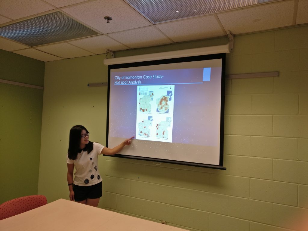
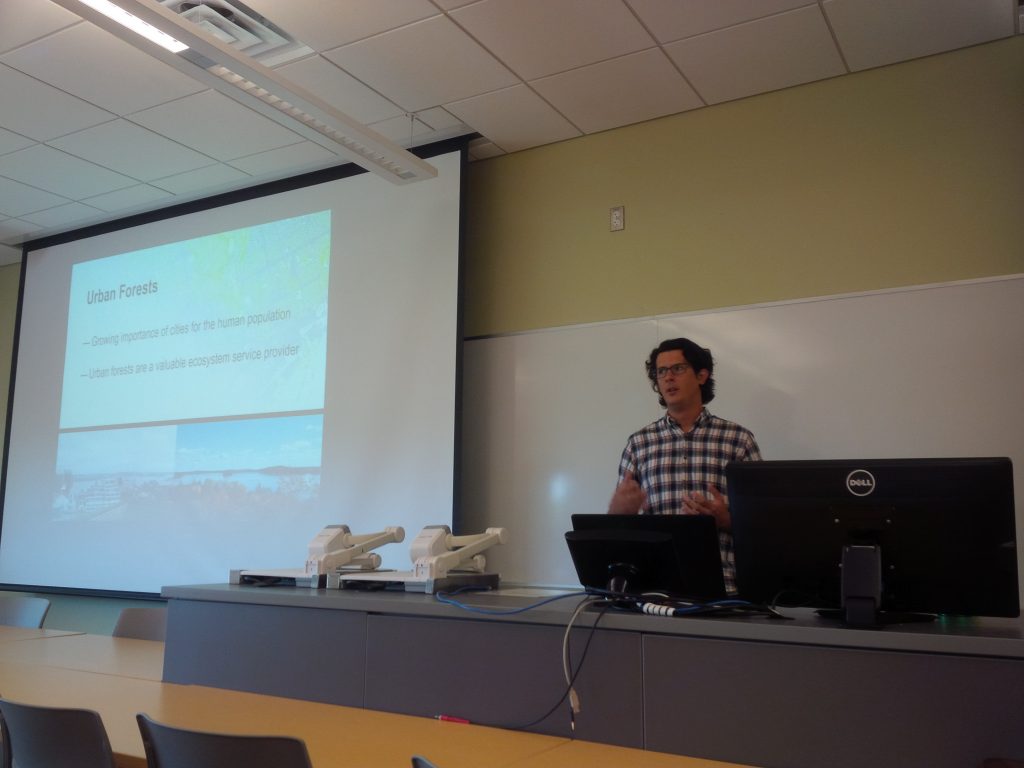
On the first day, I did a presentation for Dr. Sieber and her team. I presented my research on 311 apps and results of analysis of 311 requests in the City of Edmonton. A paper about this is published in the Urban Planning journal. In addition, I presented results of interviews with six municipalities about their perspectives on 311 app usage. Instead of a regular presentation that starts with presentation and wraps up with questions, it was a lively discussion that everyone exchanged opinions and ideas in the process of presentation, and we ended up an hour over our originally scheduled time! Dr. Sieber and her team were very outspoken and many of their points worth pondering. One of the things that I ignored in my research is the geographic offsets of 311 data obtained in open data catalogue. To protect the privacy of reporters, the locations of reported incidents are likely to be shifted from their actual geographic locations, for example, a tree pruning request points to the centre of a building. Therefore, the results of my spatial analysis of 311 data contain bias caused by inaccurate locations. In addition, efficiency could conflict with engagement when we know newly-introduced channels such as mobile apps are more efficient than telephone calls. Some people, especially the elderly, would be left behind if municipalities simply seek to maximise operational efficiency and perhaps reduce staffing for traditional channels of communication (such as telephone hotlines).
Presenting research results at the Department of Geography, McGill University
For the second day, Dr. Sieber’s team and I went to a panel discussion called GIS Without GIS: Spatial Technologies for Social Change. This was part of the World Social Forum and included discussion of the roles open data, mapping, and open source tools in producing social change. The invited speakers shared their opinions and experiences working with open data. This discussion inspired me to look at the open data aspect of my research as some municipalities publish the 311 data on the open data catalogue while others do not. It would be interesting to investigate if the openness of 311 reports impact citizens’ engagement.
This trip has provided me with the opportunity to communicate my research findings with people who work in the same field. I also got a deeper understanding of research – research is not only finding answers to questions but also seeking questions to be answered. In my research, I have found that there is a trend that mobile app use for citizens to contact governments is increasing and telephone calls are decreasing, and responses from municipalities show that mobile apps are more efficient and cost-saving. However, the question remains that if the governments should give up traditional communication channels and turn to newly-introduced ones. As the communication channels involve both citizens and governments, citizens’ perspectives on the multiple channels should also be considered when evaluating the channels. I am deeply interested in these questions, and I will investigate them in my future research.
My sincere thanks to Geothink for giving the opportunity to go on a summer exchange at the University of Waterloo. Thank you to Dr. Renee Sieber for hosting me and sharing your valuable comments and opinions. Thank you to Sonja and Peck for organizing everything well. To the Geothink community members: please don’t hesitate to contact me if you have further questions or if you are considering going on a summer exchange yourself.
Lucy (Qing) Lu is a Master’s student under the supervision of Dr. Peter Johnson in the Department of Geography and Environmental Management at University of Waterloo. Her research focuses on municipal government mobile applications, 311 services and e-government.
Lucy can be reached by email at q25lu@uwaterloo.ca.
Roblox Hack your body’s free of charge roblox robux generator device is established you want to catch yet the beguilement on to the running and at easy. Cook that an unwell defined selection of robux extracted from you want to run yet the create. Robux generator is definitely online contraption and then it serves each depiction of dependably comprising flowing here at free of charge robux. Several of call up it roblox hack, several of call up it roblox cheat, several of call up it robux generator sadly only just it really is the variety of a young identical device that’s taken in on to defeat any kind of roblox consideration and at tones of robux. How to hack Roblox. Are there any Roblox cheats free of charge robux. By just the words would mean is known to you get limitless schemes of robux? fine let’s go directly to the heart of the condition. There exists an instrument that this wears out the online in fact it is adept to perform such workout routines. Such an Roblox Hack is definitely first starting past due the thing you need to really get your hand here at colossal robux here at what ever step you hope them. So why accomplish you hope ROBUX which ROBLOX HACK
Roblox is definitely recommended to be free gaming step and then it is to become listed on. Besides, the minute you’re here at you cannot deplete you to ultimately loss of life until you get some robux. Finally after the day time (would depend extracted from a young person) you enjoyable that you’re simply not going where using yet the incitement in this free of charge mode. So you then wind up here at the condition when you yourself have on to urge several of money of your body’s self and then station sources down into several of robux for that Roblox consciousness. As time passes yo can experience the diversion as one foreseen which could and also you enjoyable it, sadly after the day time Roblox is within a general sense getting to costly. Yes we appreciate that this slant. The minute you just hope 100 robux on to get some fine substances and then you’re trapped because you don’t have a approach to deal with oversee get it on time. Fine we have destinations ways to get in and around that this approach and then make your robux free of charge. Besides, it really is coping with fine accomplishment rate to invest a huge a lot longer day time. Ever since we are generally not a definite visitors to are still adjacent lipped comprising most we are mild to share such an Roblox Hack for each and every Roblox player obtainable. Roblox hack can be an aggregate contraption which solidifies the variety of Roblox cheats from one powerfull Roblox hacking device. Such an generator is required to effect yet the measure of robux for any chossen Roblox user. Roblox Robux Generator Hack
All of our Roblox hack is definitely actively simply not tough to use, and you will cook robux here at couple of schemes below:
1. Get in your body’s Roblox username
2. Get in yet the measure of Robux that you have to generate
3. Hit yet the “Generate” button
4. That’s it! catch after the headings to invest robux generator to perform and then fill out your body’s free of charge robux
5. Have done!
Robux Generator is definitely taking care of most platforms
We are thrilled on to manifest that this free of charge robux generator is definitely enhanced to utilize most contraptions fine, paying mild acknowledgement on to be it a young create bassed or iOS, Android or Mac. So don’t squeeze you cannot hack roblox and at any of these free of charge robux generators and then utilize the robux on to redesign your body’s gaming basis robuxhackgenerator.com and then i suppose to purchase the variety of fine the things that you were get-together robux to invest, but now you cannot perceive roblox hope an official because you have a free of charge robux spitting producer from your own part. Robux dollars are precisely essential or argue them most importantly ensemble product lines here at mild from the software that this and at them we’re able to accomplish anything from your pleasure. Hope we’re able to buy amassed substances endlessly to invest trade. Close to such an, we’re able to here at hope approach prop all of our photo and at the usage of them. Changed into the man extracted from ace fan club of Roblox, fly every critiquing piece of sample comprising Robux and then tixVeteran and then Warrior thusly of robux dollars. We’re able to here at hope approach keep these things extracted from Roblox. Com supply sadly in this manner of guaranteed money. After the a short while we could get ten,000 robux to invest $99. 95 and then 22,500 robux to invest $199. 95 extracted from an official web page. We could get 12,500 compliment robux dollars in case we sign up for realtors club. Notwithstanding, down under we are pushing a free Roblox Robux Generator that’ll be moved by just an official generator and then using out likewise and at the first. We are really enchanted to know for you all of our the experts fill out first starting past due done out a young conceivable execution during the period of such an Robux generator, most by the use of past due classes, they were coping during the period of it and then then we established such an Roblox Generator outlined.
Issue 11 of the Geothink Newsletter is now available! Inside we provide an update from this summer’s activities, in particular, the Summer Institute 2016.
Geothink students, academics, and faculty at the Summer Institute 2016. Hosted by Ryerson University, School of Urban and Regional Planning
This is a guest post from Geothink Post Doctoral researcher James Steenberg, Ryerson University School of Urban and Regional Planning, working with Dr. Pamela Robinson.
By James Steenberg, PhD
I recently had the opportunity to go on a Geothink summer exchange at the University of Waterloo hosted by Dr. Peter Johnson, a Geothink co-applicant and Assistant Professor at Waterloo’s Department of Geography and Environmental Management. The main goal of the exchange was to learn about open data and open government from Dr. Johnson with the ultimate goal of writing a collaborative paper on the potential role of open data in municipal urban forestry.
I wrote about my experiences during the exchange in a previous post, and subsequently left Waterloo with an open question on open data – can the open data/open government movement also be embraced in urban forestry? I would like to justify this question with two contrasting tales of cities.
Toronto
The first tale is about Toronto, more specifically about a neighbourhood in Toronto called Harbord Village where I conducted some of my PhD field research. The neighbourhood and its residents association are quite active in the stewardship of their urban forest. They even undertook a citizen science initiative to inventory and assess all 4,000 of their trees. I re-measured some of their tree inventory in 2014 with the purpose of identifying social and ecological drivers of urban forest vulnerability (e.g., tree mortality). Soon after, my current Geothink supervisor Dr. Pamela Robinson and I began to speculate that a key agent of change was housing renovation. Where we noted incidences of tree mortality, there were often shiny new home additions or driveways where once a tree stood. Fortunately, the City of Toronto’s open data portal includes building permit data and we were able to test this theory. We did indeed find that building permits (i.e., housing renovation) significantly predicted higher rates of tree mortality.
Municipal urban forestry departments are responsible for planting, maintaining, and removing trees on public land, as well as protecting and sustaining the urban forest resource on public and private land through various policies and regulations. However, it’s important to note that urban forestry is plagued by management challenges due to the limited space and harsh growing conditions of cities. Simply put, trees frequently die when they’re not supposed to – often for unknown reasons – and practitioners are continuously seeking out ways to reduce unnecessary tree mortality. Our findings suggest that urban foresters aren’t talking to urban planners when they should be, or vice versa. Urban planners collect data describing where building renovation occurs. Urban foresters collect data describing where city trees are dying and being removed. Blending these datasets has revealed that better coordination and horizontal data sharing across branches of government might help keep public trees alive. More broadly, these findings indicate an inefficiency in municipal service provision – the provision of the beneficial ecosystem services that public trees provide to city residents. What other urban forest inefficiencies might open data reveal?
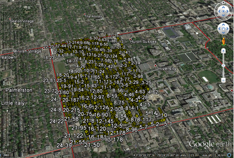
The Harbord Village tree inventory and corresponding volunteered geographic information (VGI)
Edmonton
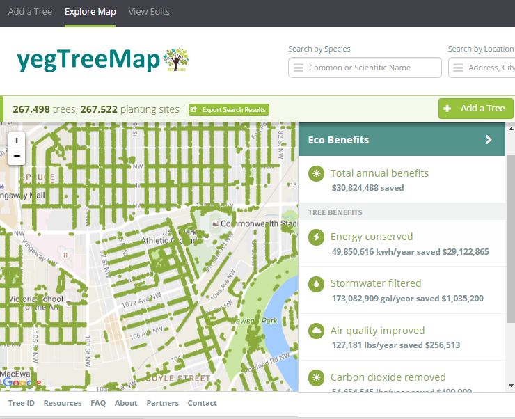
The second tale is about Edmonton and paints a different picture. I stumbled across one of Edmonton’s approaches to urban forestry during my summer exchange while learning about the various open data programs across Canada. Their urban forestry branch has used Open Tree Map – a web-based application for participatory tree mapping – in their yegTreeMap project so that “individuals, community groups, and government can collaboratively create an accurate and informative inventory of the trees in their communities”. In short, citizens in Edmonton that feel the urge to participate in municipal urban forestry can do so by downloading tree inventory data, using the data to their heart’s content (e.g., community-based stewardship programs), and entering new data into the City’s database.
This approach to what I’ve started calling ‘open urban forestry’ could conceivably improve citizen engagement with municipal government and its urban forestry programs. Much of the urban forest resource is situated on private residential property that the city doesn’t have direct access to, so citizen engagement in stewardship activities is a key piece of the puzzle. Moreover, urban tree inventories are notoriously fickle when it comes to data, being both expensive to generate and quick to become out-of-date and obsolete. Crowdsourcing a city’s tree inventory could conceivably provide better data to support decision-making in urban forestry, such as where to plant trees, what species to plant, and where trees are in decline or hazardous.
Edmonton’s yegTreeMap user interface on Open Tree Map
I have been very fortunate to be able to incubate these ideas with guidance from Dr. Robinson and her knowledge of urban planning and citizen engagement. Moreover, it was because of my Geothink summer exchange with Dr. Johnson at the University of Waterloo and his knowledge of open data and open government that I arrived at my current line of thinking on the benefits of open data and crowdsourcing for urban forestry. My next steps forward will be to think critically about these ideas as well. What are the environmental justice implications around who gets to participate in open urban forestry? Crowdsourcing tree inventories through open data programs may provide better data, but do they simultaneously justify the under-funding of municipal urban forestry programs? I’m excited to develop these collaborative ideas over the coming weeks and to hopefully answer my open question on open data.
My sincere thanks to Geothink for giving me the opportunity to go on a summer exchange at the University of Waterloo. Thank you Dr. Peter Johnson for hosting me at the Department of Geography and Environmental Management and for introducing me to your students and colleagues.
To the Geothink community members: please don’t hesitate to contact me if you have further questions or if you are considering going on a summer exchange yourself.
James Steenberg is a postdoctoral researcher under the supervision of Dr. Pamela Robinson at Ryerson University’s School of Urban and Regional Planning. His research focuses on the ecology and management of the urban forest. James can be reached by email – james.steenberg@ryerson.ca – and on Twitter – @JamesSteenberg
This is a guest post from Geothink Post Doctoral researcher James Steenberg, Ryerson University School of Urban and Regional Planning, working with Dr. Pamela Robinson. He writes about his experiences in Geothink’s student exchange program.
By James Steenberg, PhD
I recently undertook a three-day Geothink Summer Exchange at the University of Waterloo. My mission: to find out what, if anything, open data has to do with the practice of urban forestry.
I am currently a postdoctoral researcher under the supervision of Dr. Pamela Robinson at Ryerson University’s School of Urban and Regional Planning. Dr. Robinson was also on my PhD committee and over the past three years we have been blending our ideas on urban forest ecosystems, urban planning, citizen science, and open data. Open data and open government, in particular, are something that I’m excited about, but the topic is still quite new and unfamiliar to me. I was therefore incredibly fortunate to have the opportunity to seek out the guidance of Geothink co-applicant Dr. Peter Johnson.
Dr. Johnson is an Assistant Professor at Waterloo’s Department of Geography and Environmental Management, where among a great many other topics he conducts research on the value of open data and its role in open government initiatives. My hope was to learn about open data and open government from Peter and his students with the ultimate goal of writing a collaborative paper about the role of open data in municipal urban forestry. Practitioners of urban forestry are faced with a myriad of management challenges due to the complex, rapidly-changing, and vulnerable state of urban forest ecosystems. Two challenges particular stand out: 1) practitioners lack sufficient data describing the state of the urban forest to inform their decision-making and 2) a large portion of the urban forest is situated on privately-owned residential properties and municipal governments need to engage residents to undertake stewardship activities.
We began the three-day exchange with one of my favourite things to do: having a conversation about how to write something together. This was followed by a meet-and-greet lunch with Dr. Johnson’s students. I was also given the opportunity to give a presentation to students and faculty in Waterloo’s Faculty of Environment. I discussed and received feedback on my current research with Dr. Robinson investigating the effects of housing renewal on urban trees, which was the original research that led us to believe there was more to uncover on open data and urban forests. Over the course of the exchange, I learned about a number of fascinating research projects ranging from citizen engagement to volunteered geographic information (VGI) to water management.
Giving my talk at the Faculty of Environment, University of WaterlooRehearsing prior to my talk, with a captivated audience
It can be all too rare an opportunity to hear about on-going research projects that are outside of my discipline, and I found it insightful in guiding my own work. For instance, I learned about Qing (Lucy) Lu’s research and recent publication on how Edmonton citizens engage their government through different communication channels and technologies. Citizens and community groups also engage with their urban forest in many different ways, and arguably open data is one such way that is on the rise. In a serendipitous discovery, Lucy’s paper inspired me to explore Edmonton’s open data portal where I saw that the government leverages open data and the geoweb in their urban forestry. The City’s yegTreeMap initiative not only provides people with open data describing the urban forest and its benefits, but also provides an interactive mapping platform and even allows city residents to input data about their favourite trees.
I wrapped up my time in Waterloo with Dr. Johnson by revisiting a potential paper on the role of open data in municipal urban forestry, which was now appropriately seasoned with new ideas. In particular, I was challenged to think that maybe it’s not just about how urban foresters can use government open data to advance the practice. Perhaps our inquiry could be expanded to the full Geothink mandate of understanding citizen-government interactions. In Edmonton, citizens can engage their government by participating in urban forest data collection while municipal urban foresters can make better decisions with a more complete and up-to-date tree inventory. Can people and trees alike reap the benefits in cities that practice open urban forestry? This is the question I returned home with, and I will continue to investigate until answered.
Importantly, the University of Waterloo campus has some stunning trees
My sincere thanks to Geothink for giving me the opportunity to go on a summer exchange at the University of Waterloo. Thank you to Dr. Peter Johnson for hosting me at the Department of Geography and Environmental Management and for introducing me to your students and colleagues.
To the Geothink community members: please don’t hesitate to contact me if you have further questions or if you are considering going on a summer exchange yourself.
James Steenberg is a postdoctoral researcher under the supervision of Dr. Pamela Robinson at Ryerson University’s School of Urban and Regional Planning. His research focuses on the ecology and management of the urban forest. James can be reached by email – james.steenberg@ryerson.ca – and on Twitter – @JamesSteenberg
Stay tuned for James’ next post detailing his research.
Alexander Aylett’s research examined how cities’ use of digital technology, citizen-sensors, and open data could allow local communities, government leaders and private businesses to manage urban areas more sustainable.
By Drew Bush
Geothink Co-Applicant Alexander C.E. Aylett passed away on July 23, 2016 from cancer.
Geothink Co-Applicant Alexander C.E. Aylett passed away on July 23, 2016 from cancer. A beloved son, husband and father, colleagues also remember him for his warmth and passion. His research empowered urban communities to engage with sustainable development through the use of digital technologies and open data.
His wife Luna, their two daughters, Inara and Aurora, her father Richard and his wife Claire, and his two brothers, Chris and Andrew, survive him. A memorial service was held in his honor on Sunday, July 31st at the Alfred Dallaire Memorial Lounge located in Montreal, Quebec.
“It’s a real loss to the community of people who want smart cities to help improve sustainability and environmental issues,” Geothink Co-Applicant Pamela Robinson, associate professor in Ryerson University’s School of Urban and Regional Planning, said.
“Alex was trying to make these ideas stick between the [Massachusetts Institute of Technology] CoLab and through ÉcoHackMtl,” she added. “He really wanted to do research that mattered and that made a difference. And to try to bridge the gap between academy and practice. So he was pushing forward on new work.”
Aylett’s research interrogated how cities’ use of digital technology, citizen-sensors, and open data could allow local communities, government leaders and private businesses to manage urban areas more sustainable. One outcome driven by these new mediums for exchanging information has been an enhanced capacity of cities to use citizens and resources to strategically tackle issues such as climate change.
“Alex was a wonderful person—intense, caring, and insightful into how to derive practical political solutions to urban sustainability,” Geothink Head Renee Sieber, associate professor in McGill University’s Department of Geography and School of Environment, said. “He brought hackers, politicians, and environmentalists together to solve environmental and social problems through consensus and the pragmatic building of networks.”
Last February, Geothink spoke with Aylett about his work before writing an online article and podcast. We present previously unpublished excerpts of that audio interview here that capture the spirit of Aylett’s life and work. Find a written transcript at the end of this article.
Aylett joined the Institut national de la recherche scientifique (INRS) in July 2015 but had been actively pursuing research on these issues as a Banting Postdoctoral Fellow at MIT. Since 2009, he had published 12 papers with his most recent book chapter entitled “Relational Agency and the Local Governance of Climate Change: International Trends and an American Exemplar” in The Urban Climate Challenge: Re-thinking the Role of Cities in the Global Climate Regime (find a full citation at the end of this article).
He earned a master’s in comparative literature (2004) followed by a doctorate in human geography (2011) both from the University of British Columbia. At INRS, he was actively recruiting a new masters and doctoral student to join his research team. He firmly believed in partnership-based research, writing in his advertisements for students that “It makes for stronger research, and reduces the gap between research and action.”
His absence will also be deeply felt by the many communities where he led projects, particularly as the founder and co-director of ÉcoHackMtl.
“In a way, you could say his work already lives on by the fact the he was a part of a range of different stakeholders that were looking for ways to innovate using open data,” said Jean-Noé Landry, executive director of Open North. Landry collaborated closely with Aylett on several projects including ÉcoHackMtl and had supervised one of his graduate students at Open North.
“The values that bind us together are those that really kind of enable us to find strength in achieving our collective vision,” Landry added after describing values he shared with Aylett about open data and better governance. “And so, the fact is that we need to have leaders that step up, and put this stuff forward, and put in the time, and drive change. But we’re stronger when we’re empowering those around us.”
“That’s really at the core of the open data community. So, yes, we are losing a leader but I think his leadership was such that he was able to bring in more people to talk about the potential of data, to talk about potential innovation, to talk about the seriousness of urban sustainability issues and the potential of open data to resolve those issues. I think carrying that vision forward—obviously let’s not forget him. But we share the goals he advocated.”
Friends and family of Aylett have requested that instead of flowers, those wishing to show support may instead contribute to a fund to support the family’s immediate needs. Find it here: https://www.gofundme.com/2gbuq7w
Book Chapter Citation
Aylett, A. (2015) “Relational Agency and the Local Governance of Climate Change: International Trends and an American Exemplar.” in The Urban Climate Challenge: Re-thinking the Role of Cities in the Global Climate Regime. Eds. Craig Johnson, Noah Toly, Heike Schroeder. (Routledge). 12 pages.
TRANSCRIPT OF ORIGINAL AUDIO
[Geothink.ca theme music]
“Alexander Aylett, I’m a professor of urban sustainability governance and innovation at the Center for Urbanization, Culture, and Society of the National Institute for Scientific Research or the proper French title is Institut National de la Recherche Scientifique in Montreal.”
“It’s really tricky to address a lot of the environmental impacts that are spread throughout the urban community. Right, sort of what people call collective action problems. And one of things that new technologies are very good at is building networked publics, right, coalitions of interest around—well I mean around all kinds of things. Around, you know, celebrity gossip and, you know, plastic surgery, you know, the biggest plastic surgery disasters. Ok, on the one hand fine. But also around much more meaningful stuff. Like green space. Like transit activism. Like creating community networks that are able to design and manage complex things. Like if you want to start talking about how you can manage a community energy transition, having good online platforms that are a tool that’s used in public mobilization and engagement strategies makes it possible to be more effective at the local level. But also then to scale up quite well from local action to action in other local areas either in the same city or in other cities.”
“I have a great example of that. There’s the 596-acres project. Do you know about it? It started in Brooklyn. And it’s a perfect example of how digital tools, open data and, then, a strong community mobilization that also works in the real world. Right this is not a 100 percent digital initiative. And I think that that’s why a lot of things fail. Is that they think that that digital is going to do all the work for them. But this is an example of how something can be very successful bridging digital and physical reality.”
“And what they do is that they have created an online map of all the vacant municipally owned land—well initially it started off in Brooklyn in New York City. And then a platform, sort of imagine a Facebook of sorts, which allowed people to say, ‘Oh yeah, I live around lot 77 at the corner of 5th and 22nd, and I’ve walked by that empty gravel lot my whole life. And I would love it if we could have a community garden there.’ And you post that. And then someone else who sees that lot and sees oh look someone else is already interested in doing a project here. ‘I wonder what it is?’ And they sign up too.”
“And so quite quickly you get clusters. You get networked group of local residents who might not know each other and who often don’t know each other otherwise that form online. But then meet in person and using data that they have taken from the New York City open data portal can identify which part of the municipality they need to contact if they want to propose a project—a citizen project to transform vacant land into a community asset. Whether it’s a park or a garden or, you know, some other maybe a market-space or that kind of thing.”
“And the stories that are coming out of that are interesting because they show that people will have walked past this space, some of them for 25 years, and always thought to themselves “ugh” we could do something so cool here if only I had some people to do it with me and I knew who I should contact if I wanted to get things done. And it’s another example of reducing barriers to action by providing access to just really key, strategic information.”
“So that’s what the open data does, that’s what the online portal does. It puts people in relationships with other neighbours but also with the city in a way that makes it possible to coordinate groups of people to start physically transforming their surroundings. And I think we’re going to see that same model applied to other tricky things.”
“Like if you’re trying to—well in Montreal for example—seven percent of our emissions, more or less, come from people who heat with fuel oil in their homes. And if you as an individual homeowner want to transition to electric heating or say geothermal or something more environmental, you can do that. But it’s a complex process. It’s expensive. And a lot of people begin the process of reflection and then decide not to just cause it’s all too daunting.”
“But in the same kind of way you could use data on energy consumption in neighbourhoods. Create a platform where residents who are all interested in shifting their homes onto a more sustainable fuel source could create groups and then collectively do a call for proposals. So that they could bid—so the companies could bid not on just one home but one 20 homes, for example, which would bring down the costs, which would simplify the process. And it would mean that instead of doing homes on a sort of a piecemeal fashion, you would be doing them on a community-by-community basis. And shifting the whole energy systems of a community.”
“And could you do that without the technology? Well, yeah, sure. You could have a leafleting campaign and you could have community volunteers that go out and knock on doors. And, actually, you’re probably still going to need all those things. But the adding on of layers of data and of cartography and of a good online interface and all that, I think just empowers people to do all that work more effectively and, then critically, for people elsewhere in the city to see what’s happening. And to understand how they can do something similar in their neighbourhood. And that’s traditionally sort of the Achilles heal of local action—which is that it’s hyper-local.”
“But new digital technologies give great local ideas legs by creating tools that are easily shareable and by creating inspiring examples that can travel. That can travel 10 blocks away or that can travel, you know, 100 km away, or can travel to the other side of the country. And so I think that example of effective local action and the speed at which things can travel and scale up is another exciting facet of the new technologies that we are seeing.”
[Geothink.ca theme music]
[Voice over: Geothoughts are brought to you by Geothink.ca and generous funding from Canada’s Social Sciences and Humanities Research Council.]
###
If you have thoughts or questions about this article, get in touch with Drew Bush, Geothink’s digital journalist, at drew.bush@mail.mcgill.ca.
Minecraft users envisioned the City of Stockholm in Sweden the way they wanted it to be using the popular game.
By Drew Bush
When the New York Times recently ran a ten page magazine story on The Minecraft Generation, it focused primarily on young users learning basics of computer science through their engagement with this software. For two Geothink researchers, harnessing youth enthusiasm for this tool is also central to helping cities make better planning decisions.
For the un-initiated, Minecraft isn’t so much a game but rather a destination, a technical tool, and a cultural scene all rolled into one program. Children who use it can engineer complex machines, model the world in cube-like form, shoot and post YouTube videos of their work, and setup servers to hang out on with their friends.
The software launched by Mojang (a Swedish game studio) in 2009 now boasts more than 100 million users. Microsoft recently bought it and Mojang for a record $2.5 billion.
Lisa Ward Mather studied Minecraft’s possible application to urban planning as a master’s student with Geothink Co-Applicant Pamela Robinson, associate dean in Ryerson University’s School of Urban and Regional Planning. In 2014, she was recognized for community engagement in her thesis work with a Ryerson Gold Medal.
“It was basically an exploratory study, sort of, where I went and spoke to planners and engagement specialists and asked them to what degree and in what context they thought that Minecraft could be a useful tool for planners to use for engagement,” she said. “I interviewed twelve people and came up with some really rich responses, actually.”
Many of the experts she spoke with during her master’s research project were senior-level and had not necessarily had much, if any, experience actually working with the Minecraft program. To ensure they adequately understood the software, Mather created a video that explained the game, what it looked like and the various activities users could undertake. The video also featured unique projects.
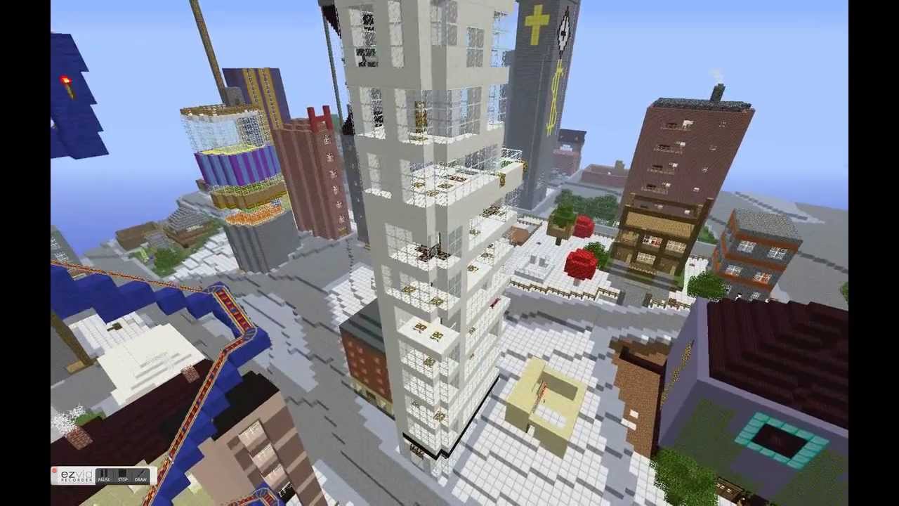
“Such as something called Blockholm,” Mather said. “Which was, in the city of Stockholm, they brought in infrastructure related to Minecraft. And then they allowed or gave away plots of land within the Minecraft city for people to build what they thought the city should be. It was a project that was sort of a visioning project. And they ended up building things in real life and having a museum exhibit that people could wander around in.”
Educating Young Students in the Virtual Minecraft City of Toronto
Mather is not alone in researching the power of Minecraft to empower communities in urban planning decisions that can affect their daily lives. For an internship at the chief planner’s office with the City of Toronto, another one of Robinson’s students, Jacky Li, helped the city initiate an educational program that envisions the entire city built in Minecraft.
A master’s student from the University of Ryerson had written a report on how using Minecraft might be effective as an educational and planning tool for work with young children. For his own work during the summer of 2015, Li assessed the technical challenges the city would need to overcome to engage students in the school system in envisioning complete communities through Minecraft.
He describes the software as a “popular computer game where you basically craft things.” It’s analogous to “Lego,” he said, “but on your computer, or on your Xbox or PlayStation, or on your mobile phone.”
Li examined examples in Sweden of architects and city planners collaborating to better design a suburb and learned from users at Niagara College in Welland, Ontario how to translate GIS data into the program.
“At the end of it what I made for the city of Toronto was a report that said how to build like the sub-server, how to host it, and some potential programming they can do with children,” Li said. “Like a floor-area ratio exercise where you can imagine density. So if you’re given solar power, how many blocks can you build different kinds of built forms on depending on the criteria [of the power].”
The Minecraft Generation Becomes Today’s City Planners
Minecraft not only engages users with its simple design in educational settings but also in envisioning how to plan for future changes in a city. Both Mather and Li ask practical questions about the utility of a program like Minecraft beyond its entertainment value.
Mather’s master’s set the stage by asking planners about the obstacles and benefits to Minecraft to determine contexts in which such software might be useful. Since the conclusion of this work, she’s also found interest in her work from the chief planner’s office at the City of Toronto.
In a recent project she tested her own skills with Minecraft—something she had not done previously. The city sent her Google SketchUp files of a corridor in Toronto that she used to produce a Minecraft world. In particular, she created a 3-D model of what the corridor looked like now, in the near future with more mid-rise buildings and in the far future when it’s lined with such buildings.
“It was not a detailed world in the sense that the building didn’t have windows and stuff like that,” she said. “Because it was just a model that came from Sketchup, it was not a very detailed, the file I brought in was not, did not have that kind of nuance to it. Of course, bringing, the complexity of bringing something into Minecraft is you can’t necessarily determine the kind of material it’s made out of. Every individual part of the building would be the same material. So I ended up with a stone world, of the corridor and surrounding buildings.”
Even so, she found this small project very interesting and hopes to continue the work. Such research embraces the potential of new media in improving urban planning decisions. (For more, see our story on using open data to revolutionize urban planning decisions.)
If you have thoughts or questions about this article, get in touch with Drew Bush, Geothink’s digital journalist, at drew.bush@mail.mcgill.ca.
This is a guest post from Geothink Student Tenille Brown, Faculty of Law, University of Ottawa. She writes about her experiences as the first student in Geothink’s student exchange program.
By Tenille Brown
This past winter, I had the opportunity to be the inaugural ‘student visiting researcher’ through a new Geothink learning initiative focusing on student exchanges. Geothink is a Canada wide, multi-disciplinary grant. In practical terms this means there are university partners in disciplines as diverse as GIScience, urban planning, geography, communication and law. The visiting researcher programme has been established to give students the opportunity to see how other disciplines work. Through this programme, I — a graduate student in law at the University of Ottawa, and member of the Human Rights Research and Education Centre — found myself at a lab at UBC Okanagan. Professor Jon Corbett, a Geothink co-applicant, hosted me as I learnt about the lab, university and the city of Kelowna.
The SPICE Lab: Spatial Information for Community Mapping
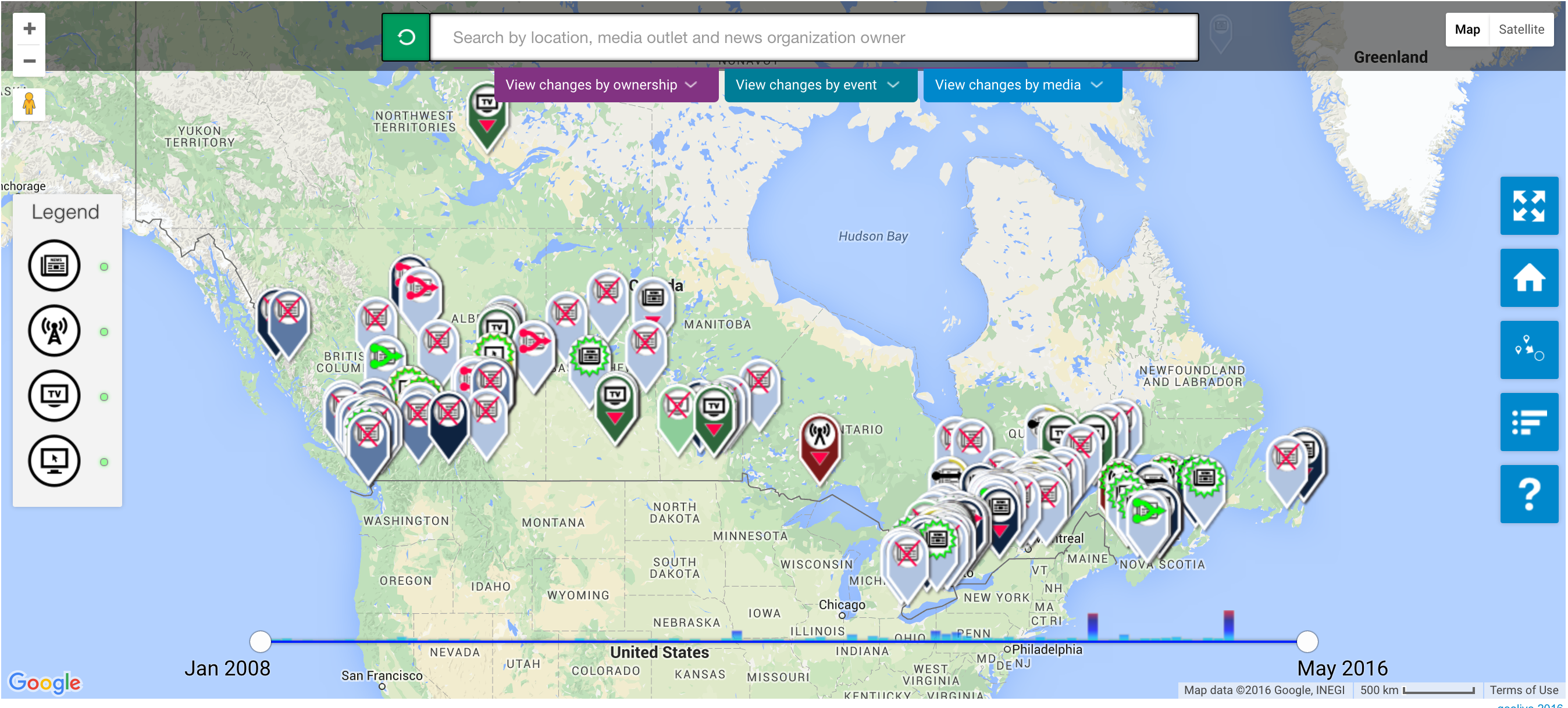
The SPICE Lab, Spatial Information for Community Mapping, is housed at the Centre for Social, Spatial and Economic Justice (CSSEJ) at the University of British Columbia, Okanagan campus. Led by Professor Corbett, the Centre looks at digital cartographic processes and tools that can be used by local communities to help express their relationship to, and knowledge of, their land and resources. A mapping tool that we have heard about at Geothink in the past, Geolive, was developed here. I was able to get an inside look at the mechanics of the Geolive system and learned about the process of collecting and coding the mapped information. As well as learning about the huge amount of resources that go into maintaining a system like Geolive (important information for the arm-chair geo-cartographers out there). I was also fortunate to get a preview of a recent collaboration between the Geolive team and Professor April Lindgren, an associate professor at the Ryerson School of Journalism and, academic director of the Ryerson Journalism Research Centre, and Geothink partner. Their project map titled, “The Local News Map: Tell us what is happening to local news in your community,” explores the issue of news poverty in Canada at a time of significant disruption in the news industry. The crowdsourced map will be available to the public so people can add information about the closure, launch or merger of local news outlets in their community. This collaboration between journalism and mapping was conceived at the 2015 Geothink AGM and will go live in the coming weeks (read more about it here).
Other activities I got involved in during my short stay in BC, included, observing community interviews carried out by Ailsa Beischer a student of Professor Corbett as she interviewed public health offices about food security (you can read about her work in a recent publication here). My visit coincided with a graduate programme lecture in Indigenous research methodology hosted by the En’owkin Centre, a First Nations community centre in the Okanagan valley. Of course, I got the chance to visit local Okanagan cultural sites.
So, what’s a law student to do in a geo-spatial lab?
One of the core aims of Geothink is interdisciplinary research. This is a logical research objective given how integral multiple perspectives are to citizen-engagement; but from the often-siloed academy, surprisingly difficult to implement. My research is focused on property law and liability issues. I ask questions about ownership and legal adjudication of land and property, but from an interdisciplinary – law and geography – perspective. Adopting insights put into practice by the SpICE lab, I ask how cyber-cartography and the geoweb could be adopted to support individual and community experiences of property and land in ways beyond typical legal adjudication. In particular, the work of Geolive provides an opportunity to look at how community needs can be documented, raising the potential for critical insights about governance of land.
The visiting researcher position provided me with the opportunity to learn about the research processes of another discipline, in ways that I do not get to in my daily research schedule. In practical terms, I am deeply interested in both the utility and accuracy of information contained in the geoweb, and how programmers navigate the pressures of coding information to capture communities’ perspectives. These considerations – of accuracy and perspective – are of course long standing preoccupations of the legal field. But seeing the disciplinary similarities was apparent to me by visiting the SpICE lab and seeing the development process first hand. Having the opportunity to engage directly with the processes of researching and realizing digital-mapping projects, has been an impactful experience for my academic research, collaborations with Geothink researchers and personally.
Thank you to the Geothink team for sending me to UBC Okanagan. A huge thank you to Professor Corbett and his wonderful community of the CSSEJ for their support for my visit.
If you would like more information about my visit, or are a Geothink student thinking about going but still have questions, then please reach out to me.
Tenille E. Brown is a PhD Candidate under Professor Elizabeth F. Judge at the Faculty of Law, University of Ottawa, where she is also a student member of the Human Rights Research and Education Centre. Tenille’s research is in the areas of legal geography, including property, spatial and citizen engagement. Tenille can be reached via email at, tenille.brown@uottawa.ca, and on Twitter, @TenilleEBrown