Author Archives: Drew Bush

Guide Provides Citizens Access to Open Data Literacy

The Geothink Citizen’s Guide for Open Data found at citizens-guide-open-data.github.io

By Drew Bush

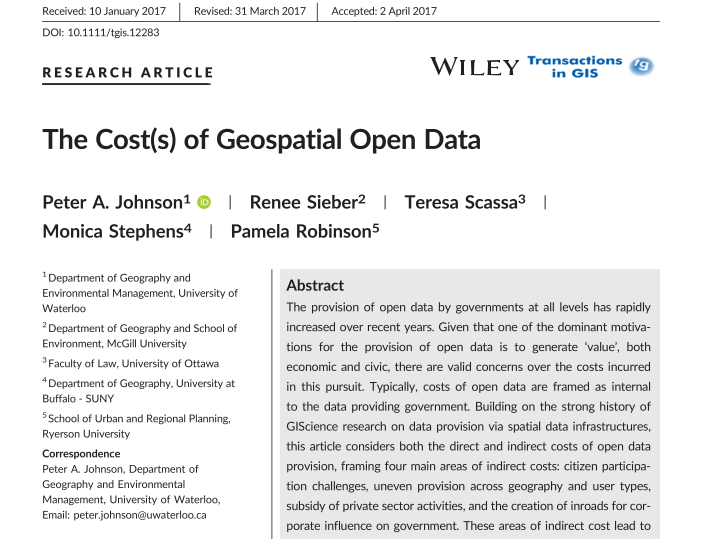
Screenshot of the Geothink Citizen’s Guide to Open Data link on Geothink.ca.

You may have noticed a new banner gracing the front right portion of the Geothink.ca Web site starting last month. Click on it and it will take you to a key deliverable of this five-year partnership research grant funded by Canada’s Social Sciences and Humanities Research Council (SSHRC).

The Geothink Citizens Guide to Open Data was created by Curtis McCord and Dawn Walker, Geothink doctoral students in University of Toronto’s Faculty of Information, in collaboration with Geothink Co-Applicant Leslie Regan Shade, professor and associate dean for research in the faculty. It was first presented at Geothink’s 2016 Summer Institute at Ryerson University in Toronto when the duo were master’s students speaking on a panel.

“There’s actually still a big barrier where a lot of individual people aren’t using open data,” Walker said. “So we’re like in this moment, of saying, ‘Ok, open data has been lauded for all this potential promise.’ But it’s not exactly being used proportionally in the ways that are expected. From my experience, I’ve just seen a lot of companies or people who have very strong technical capabilities being able to work with open data. But there’s a lot of people who maybe have questions about their city or country that maybe open data can speak to. But like don’t—like wouldn’t even know to engage with it as a question you could ask of data. Or even know that open data would be a place they could go look to see.”

“These sorts of guides kind of help think about what those bridges could be,” Walker added. “And [they] address some of the literacies and capabilities required to even start to understand that you can ask questions that open data can answer.”

The Guide’s goal is to “provide citizens with tools to understand what makes up open data (OD), how it can be used in their communities, and where to find it.” Set up similarly to a Wiki page with drop-down menus, it consists of four sections on the right-hand bar entitled “Citizens Stories,” “Citizen Guide,” “Additional Resources,” and “About this Guide.”

The home page for the Guide notes that “People across Canada use technology that makes use of data as part of their daily lives” and increasingly are “starting to think about creative ways that this technology and data can be used to address issues they face in their communities and cities.” It adds that civic technology constitutes instances where “citizens come together to identify problems in their society or their community and solve them with data, computers, or expertise. Many kinds of data and their uses come up when we talk about open data and we’re going to know about them at the end of this guide.”

“It’s in no way kind of settled, right?” McCord said of the Guide. “We really intended this to be kind of a living document that people could update with their own stories or their own insights. We’re really open to ideas about how the kind of like stewardship of this thing might work. I mean, I’m much less committed to the content of the guide than I am to the idea that it can exist and be cared for. I’d rather it be everybody else’s ideas on their than mine. Because in a way, that shows it’s like kind of actually being put to work.”

McCord added that anyone interested in contributing can edit the guide by following simple instructions to use GitHub found at the bottom “Change This Guide!” link on the site. They can also e-mail the authors by clicking the “Feedback” link. Such contributions will represent the next step in the guide’s release to the public.

According to Shade, the first steps began directly as a result of her work with Geothink.

“The project began with my interest in exploring facets of data literacy, and more particularly with an interest in unpacking elements of open data for people and communities that were curious about it but not conversant with how to use open data,” she wrote in an e-mail. “Alexander Taciuk, our former [Geothink] Project Manager, was instrumental in encouraging me to pursue this project. And key to the project’s vision was the tremendous teamwork of Curtis McCord and Dawn Walker who worked on the Guide while finishing up their Master of Information degrees.”

“Curtis and Dawn wrote and designed the bulk of the Guide while also convening a small group within Geothink and locally to give advice on the content,” she added.

This year Shade engaged new students to continue work on several facets of the Guide including University of Toronto Master of Information students Dal Singh, Nicole Stradiotto and Mari Zhou and doctorate student Camille-Mary Sharp.

###

If you have thoughts or questions about the article, get in touch with Drew Bush, Geothink’s digital journalist, at drew.bush@mail.mcgill.ca.

Paper Spotlight: The Cost(s) of Geospatial Open Data

Five Geothink researchers published a new paper in Transactions in GIS this past January that reflected on four years of research into how geospatial open data can impact the relationship between government, its citizens and the private sector.

By Drew Bush

In their article published this past January, five Geothink researchers reflected on four years of research into how geospatial open data can impact the relationship between government, its citizens and the private sector. In it, they examine how geospatial open data poses challenges for civic participation related to subsidizing the private sector, being provisioned equally across geography and user type, and in increasing corporate influence on government.

Published by Transactions in GIS, the article entitled “The Cost(s) of Geospatial Open Data” concludes with the development of critical questions to guide governments that provide open data in addressing costs related to constituency, purpose, enablement, protection, and priorities.

A key table from the “The Cost(s) of Geospatial Open Data” which lays out the critical questions in each of these areas for municipalities.

“What we were trying to do is to push the conversation of ‘value’ for open data beyond the typical areas of transparency, economic innovation, and service to citizens, and look more at what the generation of value can create in terms of additional costs,” Geothink Co-Applicant Peter Johnson, the paper’s first author and an associate professor in the University of Waterloo’s Department of Geography and Environmental Management, wrote in an e-mail. “So, for example, we talk about how there is a lot of interest in how open data can promote transparency, which is a great outcome. However, this can’t be conflated with more durable challenges like citizen participation and citizen engagement.”

“Simply putting open data out there won’t move the needle on those,” he added. “Rather, government must continue to work hard and use open data to help further those ends, but not as a replacement.”

Johnson’s co-authors on the paper were Geothink Principal Investigator Renee Sieber, associate professor in McGill University’s Department of Geography and School of Environment; Geothink Co-Applicant Teresa Scassa, Canada research chair in Information Law at the University of Ottawa; Geothink Collaborator Monica Stephens, assistant professor at The State University of New York, Buffalo; and Geothink Co-Applicant Pamela Robinson, the associate dean for Ryerson University’s Faculty of Community Services and an associate professor in the School of Urban and Regional Planning.

They note in the paper that their research funded by the Social Sciences and Humanities Research Council of Canada has evolved to examine the costs of open data that have emerged, and shown that “spatial is special” and that the broader open data research community that “draws upon a different set of assumptions and literatures, would benefit from the lessons learned in GIScience.” The paper then goes on to create “a framework that details direct and indirect costs created through the process of government open data provision, drawn from the perspectives of our key informants in municipal governments. Many of the indirect costs are external to the providing organization and are not always clear or straightforward.”

“Open data may enable a kind of smoke and mirrors that obscures a government’s actual commitment to citizen participation, transparency and accountability,” said Sieber. “The challenges of using open data as a platform for citizen participation and engagement can be exacerbated where insufficient government resources are deployed to ensure that open data sets are properly prepared for release.”

Johnson agreed.

“We are just holding our hands up and saying ‘Wait, this is more complicated than you think,’” he wrote. “Especially when we think of issues like protection of privacy for health or financial data, there are a lot of things to think through in parallel to just ‘How are we going to use (exploit) this data?’ So, for future research on this topic, I think that there is a lot to be done. Who is using open data and what are the ups and downs of using it?”

The Cost(s) of Geospatial Open Data
Abstract
The provision of open data by governments at all levels has rapidly increased over recent years. Given that one of the dominant motivations for the provision of open data is to generate ‘value’,both economic and civic, there are valid concerns over the costs incurred in this pursuit. Typically, costs of open data are framed as internal to the data providing government. Building on the strong history of GIScience research on data provision via spatial data infrastructures, this article considers both the direct and indirect costs of open data provision, framing four main areas of indirect costs: citizen participation challenges, uneven provision across geography and user types, subsidy of private sector activities, and the creation of inroads for corporate influence on government. These areas of indirect cost lead to the development of critical questions, including constituency, purpose, enablement, protection, and priorities. These questions are posed as a guide to governments that provide open data in addressing the indirect

###

If you have thoughts or questions about the article, get in touch with Drew Bush, Geothink’s digital journalist, at drew.bush@mail.mcgill.ca.

Innovative Urban Planning Solutions and GPS Guided Biking – Summer Institute Day 3

Rachel Bloom, Julia Conzon and Elizabeth Barber took questions from the audience on day three of the Geothink 2017 Summer Institute after talking about their career paths post Geothink.

By Drew Bush

Geothink Co-Applicant Stéphane Roche, associate professor in University Laval’s Department of Geomatics, chats with students during a coffee break on day three of Geothink’s 2017 Summer Institute.

The third day of Geothink’s 2017 Summer Institute opened with Open North Executive Director Jean-Noé Landry discussing how Geothink’s collaborative approach begets research with practical applications for smart cities. A pair of Montreal entrepreneurs and a trio of former students elaborated on this perspective in their own subsequent presentations.

“We’re going to talk about enabling innovation,” Noe said to start the morning. “I’ve been following some of the conversations that you’ve been having with all these great folks that have come in over the course of the week…And today, you know, we’ve got an opportunity to look at a few people that have been able to do some great work.”

Two previous Geothink students followed with talks on their differing career trajectories after graduating from McGill University. Rachel Bloom is currently working as the project lead for Open North on Smart Open Cities; and Julia Conzon spoke of her work with open data at Statistics Canada. Elizabeth Barber, a master’s of public services student at University of Waterloo, talked about her summer work with the City of Montreal. They were preceded by Xavier Peich, a co-founder of SmartHalo, and Vincent-Charles Hodder, a co-founder of Local Logic.

The theme of this year’s Institute was “Smart City: Toward a Just City.” An interdisciplinary group of faculty and students tackled many of the policy, legal and ethical issues related to smart cities. Each of the three days of the Summer Institute combined workshops, panel discussions and hands-on learning modules that culminated in a competition judged by Montreal city officials and tech entrepreneurs. The goal of the competition was for student groups to develop and assess the major principles guiding Montreal’s 2015-2017 Montréal Smart and Digital City Action Plan.

The last day provided ample time for students to work within their groups to analyze Montreal’s strategic plan in accordance with a research question assigned by one of the Summer Institute’s faculty members. It also provided time for faculty members who once had been students themselves to reminisce.

“I love the summer institute,” said Victoria Fast, an assistant professor at University of Calgary’s Department of Geography. She herself has participated in the previous summer institutes in 2016 and 2017 and had just recently made the transition to faculty.

“Actually, interestingly, something we haven’t touched upon yet is the synergy between all of them. You know, Institute number one in Waterloo was volunteered geographic information (VGI) and crowdsourcing, the second one in Toronto was crowdsourcing, and this one is smart cities. And all of those concepts are just so fundamentally embedded in each other. And for—I think students who have been to all of them really get this diverse and rich perspective on Geothink from these kind of very relevant topical areas.”

“This one, in particular, I really like from the student perspective, the employment opportunities is really great to hear,” Fast added about the presentations on life after Geothink. “The idea of social entrepreneur, social innovation. I think students in a university really need some hope about jobs and job prospects.”

The Summer Institute faculty, city officials and tech entrepreneurs helped to judge the work of each student group at the end of the day. But the real value lay in the new ideas and understandings each student gained.

One group explored which city services should be prioritized for digitization first while another determined how to quantify what appropriate inclusion of citizens in smart cities of the future might look like. Others examined what open data should be released by cities, the advantages of public Wi-Fi, and how cities can foster collaboration between innovators.

“We tried to develop sites for innovation learning,” Seyed Hossein Chavoshi, a PhD student from Laval University, said. “So there are many things actually we want to take into account. For example, there are the functionality and the design of the place where we want people, for example, to test apps that are actually developed by the municipality. So to do that and to find these places there are many aspects. The functionality is one of them. Another is the ethic. But the functionality is a core one of them—when you want to invite citizens from different cultures, from different groups, from different ages you have to find a place that can at least accommodate all different ages.”

Chavoshi added that he found this year’s Summer Institute quite informative.

“I’m so technical from an engineering point of view,” Chavoshi said. “But here we were so diverse. So like people from law and from a social geography background and [subjects] that, actually, they aren’t often gathered all together. So before that I didn’t actually know that we had to take into account all these aspects. But when I was here and I just listened to the other peoples’ points-of-view, from their background, it helped with when I want to, for example, develop something that can be fascinating to the citizens in a smart city.”

Geothink students, staff and faculty at the 2017 Summer Institute at McGill University in Montreal, QC.

###

If you have thoughts or questions about the article, get in touch with Drew Bush, Geothink’s digital journalist, at drew.bush@mail.mcgill.ca.

Crosspost: Geothoughts on Geothink

An image of the Castlegar campus at Selkirk College with the Mir Centre for Peace visible on the right. (Photo courtesy of Karen Godbout.)

By Karen Godbout


This post originally appeared on the Rural Open Data site which reports on research taking place as part of a three year grant investigating open data best practices, policy and delivery options in southeastern British Columbia. The author is in the final year of her Bachelor’s of Geographic Information Science (BGIS) at Selkirk College and is currently working at the Selkirk Geospatial Research Centre.


I am presently completing a summer work term at the Selkirk Geospatial Research Centre, supporting its Rural Open Data study. In September, I will enter the final year of a BGIS, also at Selkirk. I came to GIS from a humanities background, after many years working in libraries. I am really fortunate to have been guided toward the possibilities for GIS within the humanities, like open government data, and will continue to focus in that area.

The Geothink Summer Institute (May 25-27, McGill University, Montreal) was a unique opportunity to meet and collaborate with fellow students from multiple provinces (Quebec, Ontario, Saskatchewan, B.C.) and academic disciplines (GIS, Geography, Law, Urban Planning), as well as varying levels of study (from undergrad to doctorate). The theme of this year’s institute was “Smart Cities – Just Cities.” While it certainly was not lacking in solid examples of policies and applications, most of the dialogue and problem solving at the institute centred on the emerging potential of smart cities. With so many standards yet to be developed, and so much infrastructure still to build, I came away with big ideas, concepts, and philosophies more than any other thing. I also learned why that is a good outcome. We stand in the enormously fortunate and powerful position of determining exactly what smart cities will be. If they are to be equitable, accessible, sustainable, social, and safe places, it will be determined by the questions we ask and answer right now.

X: What exactly is the meaning of ‘smart’ in the smart cities context? Primarily, the default concept of smart is the one developed centuries ago, meaning logical, well reasoned, and scientific. During the 1990s and 2000s, the social sciences transitioned into the idea of multiple intelligences. First, it was emotional intelligence. Then social intelligence. Eventually there were bodily, intuitive, and existential intelligences. It all became a little bit silly, which may be why we continue to return to the default. Still, there is value in considering different aspects of smart. Consider Artificial Intelligence (AI) for example. No matter how many algorithms are developed, or how much data is processed, ‘the rules’ will always limit machine learning. The elements of human consciousness that add up to smart remain a mystery, and I daresay the whole is greater than the sum of its parts. What is the algorithm for imagination? In the context of smart cities we must also ask, what is data? Again, the default is measurable and precise, facilitating all sorts of amazing, practical solutions to significant human problems. Yet humans remain unpredictable, and cities are messy. Much of what makes a place meaningful and livable for its citizens is not quantifiable. In determining the smart/just city, space must be included for the qualitative, the organic, and the random.

Y: What normative influences are smart cities to have upon the behaviour and expectations of citizens?  With smartphones, wireless, and up-to-the-minute GPS data, there comes an ability to control and personalize the urban environment more and more. Don’t want to wait in the rain for the bus? See when it’s 30 seconds away from the stop. Want the city to fill in that pothole? Submit a photo and see it move up the road-repair priorities list. Great stuff, right? The issue being, as individualized services increase, so do expectations, and the false perception that convenience is a right. The smart/just city must very intentionally cultivate engagement with the entire community, deliberately seeking inclusive input from the less enfranchised, whether it be due to language, income, age, or intellect. Fostering the communal spirit within cities will require a massive culture shift for some, and arouse the suspicion of many. The selling point is innovation. Just as in nature, diversity results in adaptability for cities. Variability creates opportunity for new ideas, social benefits, and economic growth.

Z: Can the smart cities model grow engagement and increase unity among communities?  Knowing more about someone or something brings it closer, makes it matter more. As the information age crashes into the big data minute, what any human being can know and care about becomes increasingly narrow, at least in any practical, useable way. Any group one identifies with is progressively exclusive, and may be more ideological than spatial. Constructing smart/just cities from the ground up, from grassroots neighbourhoods and villages, is the reasonable place to begin. But, generating a sense of unity among these will not simply happen once the end is achieved. Pre-existing government data, when made open, can help build community cohesion at every step, giving each group an equal voice and connecting the common links between them.

What will determine the smart city?  In this as in everything, the means matter.

Tackling The Thornier Issues Plaguing Smart Cities – Geothink Summer Institute Day 2

Day two of Geothink’s 2017 Summer Institute at McGill University in Montreal, QC featured presentations by faculty on the pressing issues facing smart cities.

By Drew Bush

On day two of Geothink’s 2017 Summer Institute at McGill University in Montreal, QC, students got their hands dirty investigating the important issues facing smart cities. Each group presented unique findings in answer to a question they were asked to investigate from the disciplines of law, geomatics and geography.

The theme of this year’s Institute was “Smart City: Toward a Just City.” An interdisciplinary group of faculty and students tackled many of the policy, legal and ethical issues related to smart cities. Each of the three days of the Summer Institute combined workshops, panel discussions and hands-on learning modules that culminated in a competition judged by Montreal city officials and tech entrepreneurs. The goal of the competition was for student groups to develop and assess the major principles guiding Montreal’s 2015-2017 Montréal Smart and Digital City Action Plan.

Before undertaking their own research, students heard from Institute faculty with expertise in each of the areas they were asked to investigate during half-hour presentations. This began with a presentation on the online, participatory mapping tool, GeoLive, by Geothink Co-Applicant Jon Corbett, associate professor in University of British Columbia at Okanagan’s Department of Geography. He was followed by Geothink Co-Applicant Teresa Scassa, Canada research chair in University of Ottawa’s Faculty of Law, who talked about the legal issues surrounding the development of applications (APPs) in smart cities. Geothink Co-Applicant Stéphane Roche, associate professor in University Laval’s Department of Geomatics, finished the morning by talking about ethics in smart cities.

“So law is in many respects about relationships, and certainly in this context is about relationships,” Scassa told students during her presentation. “And so one of the things you need to do when you are looking at and thinking about legal issues in this context is to think about what particular legal relationship or relationships you are talking about and you are thinking about. So, for example, a city may be thinking about entering into a contract with a particular service provider for a smart city’s service or a smart city’s APP. And that—there will be a relationship defined in legal terms between the city and the service provider at that point. And so that’s one relationship.”

“And there are going to have to be certain things worked out in the context of that particular relationship between the city and the service provider,” Scassa added. “The city that enters into a contract for that service may then also have a relationship with the users of that service. And so that’s another relationship. And it’s a relationship the city has to think about in terms of how it wants to define that relationship with its users.”

“There are two things that I really appreciate,” Geothink Co-Applicant Stéphane Roche, associate professor in University Laval’s Department of Geomatics, said. “The first one is the idea of talking about and thinking about smart cities without talking about smart cities. And that was the case this morning. And especially by—with the first presentation by [Jon Corbett]. I guess that what Jon has presented, you know, about participatory mapping for a community was and is really valuable for our reflection about smart cities.”

“It’s not a question of technology,” Roche added before noting that the second thing he appreciated was the interdisciplinarity of the presentations and students. “The main issue is involving community. The main issue is designing solutions that are in line with their view of space—[a community’s] view of their relationship with space.”

At the conclusion of the presentations, each student group was presented with a unique question that they had to answer. Questions were derived from each discipline and speaker’s presentation. They asked students to conduct research on how society should evaluate the usability and functionality of smart city APPs and how the additional data and APPs from a smart city create legal liability for cities that doesn’t fit within the policy structure that already exists.

“We are assessing the impact of like, I guess, the Geolive initiative,” Selasi Dokenoo, an undergraduate student at Ryerson University, said. “To clarify what it’s like and how do we assess the impact and benefits of this type of program.”

A different group worked with another site, iSearch Kelowna, for their question. The Web site makes use of open data to aid people in finding low-income rentals, supportive housing or emergency shelters within the City of Kelowna.

“For the exercise, the question is related to feedback,” Ali Afghanteloee, a doctoral student at Laval University, said. “Evaluating the functionality and usability of the web services about Kelowna. First of all, we’ve found out what is the criteria [for] evaluation. And, second, what are the tools to evaluate this kind of criteria. It’s just—we decided that, I think, that the quality criteria is very important because we decided that the user is very important. The usability. And spatially whether creating this site to find out what the services are—whether this is useable or not.”

The day concluded with each group presenting findings on what they had found during their research. For many, this proved enlightening and related well to their own work back at their home university.

Student groups worked on day two to answer research questions posed by the panelists about smart cities.

“Well, I’m interested in policy mobility,” Brennan Field, a doctoral student at University of Saskatchewan, said. “So it’s been interesting in the past few days just looking at how smart cities, in terms of an urban policy space, have become mobile and have been spreading. And so in the case of the Montreal it was interesting hearing [Harout Chitilian] speaking of how the police department is using open data to report crime. And then their initial reticence and then kind of opening up to it. So I was already familiar with that—basically that has been how police departments generally respond to that particular policy. The policy of open data related to reporting police activity.”

“And seeing how a lot of it is cross-overs between how open data as urban policy has become mobile and how smart cities as urban policy has become mobile,” Field added. “So there are a lot of similarities and cross-overs with my research. So that’s what I’ve learned.”

###

If you have thoughts or questions about the article, get in touch with Drew Bush, Geothink’s digital journalist, at drew.bush@mail.mcgill.ca.

Bringing Smart Cities to an Interdisciplinary Group of Scholars – Geothink Summer Institute Day 1

A panel introduces the idea of a smart city to students at Geothink’s 2017 Summer Institute at McGill University in Montreal, QC.

By Drew Bush

The term smart cities can mean one thing to a scholar of geomatics and something entirely different to an urban planner. The morning panelists on the first day of Geothink’s 2017 Summer Institute at McGill University in Montreal, QC enlightened more than 30 students and visitors on their perspectives.

The panel kicked off the main theme of this year’s gathering: “Smart City: Toward a Just City.” Each of the three days of the Summer Institute combined workshops, panel discussions and hands-on learning modules that culminated in a competition judged by Montreal city officials and tech entrepreneurs. The goal of the competition was for student groups to develop and assess the major principles guiding Montreal’s 2015-2017 Montréal Smart and Digital City Action Plan.

Discussion began with introductions by Geothink Head Renee Sieber, associate professor in McGill’s School of Environment and Department of Geography. Presentations were given by Stephane Guidoin, open data chief advisor in Montreal’s Smart and Digital City Office and Geothink Co-Applicants Stéphane Roche, associate professor in University Laval’s Department of Geomatics; Pamela Robinson, associate professor in Ryerson University’s School of Urban and Regional Planning; Rob Feick, associate professor in Waterloo University’s School of Planning; Teresa Scassa, Canada research chair in University of Ottawa’s Faculty of Law; and Victoria Fast, an assistant professor at University of Calgary’s Department of Geography.

“I work on the smart city and especially on the way digital technology, geospatial technology could improve the capability of citizens to be more engaged in cities,” Roche told students to begin the panel discussion. “And this is why for me, smart is really linked to citizen engagement.”

“Smart cities, for me, is based on four components,” he added. “The first one is digital, so that means the integration of engineering the urban systems, so it’s really about urban engineering and improving the efficiency of engineering structure for urban management. The second component is open, so a smart city means opening cooperation and participation. The third one is this idea of being able to give an answer for different issues based on the use of sensing, learning and sharing. This is the component where citizen engagement is really, really important. And the fourth one is this idea of urban innovation. A smart city is also really linked to this idea of innovation. Not only economical innovation but the way we build cities. And the way we build living space for people.”

Not all the panelists focused on citizen-engagement or new sensors being installed in cities. Robinson spoke on how urban planners talk about smart cities. She noted that the role of planners is to consider the public good and how this should be defined and protected in the development of smart cities in relation to issues of sustainability, equity and inclusion. Scassa noted that she teaches law and, therefore, she thinks of smart cities as sensor-laden cities that make much new data available. For her, this opens many new questions for governance processes and personal privacy.

Later in the day, Montreal City Council Chairman Harout Chitilian introduced students to the ways in which Montreal aims to blend open data, new tech and entrepreneurship to make Montreal a leader in smart cities. He spoke at the Institute even as outside McGill the city celebrated its 375th anniversary. In an interview afterwards, he offered a practical perspective on what being a smart city meant for Montreal residents.

“So first and foremost, you get accountability,” Chitilian said. “So you know where your tax dollars are going in terms of as far as the services are concerned. You know how your contracts are being managed as far as who it’s being given out to and what are the concentration of contracts in certain areas. And you also have accountability from your public safety/police forces that have now a transparent way of reporting a crime map from the city of Montreal.”

“And then now, bit-by-bit, on a service-by-service basis, you also have real-time data of the progress of the services that are delivered to you,” he added. “And we started with snow removal but there will be much more in years to come.”

After more in-depth presentations on civic engagement by Feick and Robinson, accessibility by Fast and free public Wi-Fi by Guidoin, the day transitioned into its first student activity. Groups were asked to answer three questions about McGill’s campus and enrolling as a student. The catch was that half the groups could use free campus Wi-Fi (which Chitilian had just announced as part of the city’s plan) and the other half could not use any online sources.

“I think it was a good chance to re-think about the internet that’s available in different places,” said Wonjun Cho, an undergraduate student at McGill. “I think it was personally easier to find many places using Internet and Wi-Fi. And, yeah, it would have been interesting if I had an experience in analogue as well to compare. But overall it was a lot of fun.”

As a resident of Montreal, Cho also felt strongly about the city’s move to install free public Wi-Fi.

“There are many tourists who visit Montreal every year,” Cho added. “And, especially international tourists, they often find a hard time to get place to place. And these days so many people use apps and Google maps and trip sites to find hotels. And it would definitely be an enhanced experience for visitors to Montreal. And also for people who live here because not many people have unlimited amounts of data on their cell phones.”

As the day drew to a close, students were led in a discussion by Sieber on what they knew about smart cities prior to their arrival and how the day’s events had changed their perspectives. In attendance were students of mixed disciplines ranging from geography and urban planning to law and geomatics.

“If you see what’s going on right now with the group work, getting students from different universities, from different parts of Canada—let’s face it from different disciplines—bringing together their own set of experiences and skills into a group learning situation, I think that’s a meaningful outcome as well,” Geothink Co-Applicant Jon Corbett, associate professor at University of British Columbia at Okanagan’s Department of Geography, said. “So I’m really happy to see how well the students seem to be getting on, how well they work together in small groups, and I think that, hopefully, will be laying the foundation for, you know, for future graduate students. So that when they go to conferences or, who knows, when they become academics, they will already have that relationship or those relationships in place.”

###

If you have thoughts or questions about the article, get in touch with Drew Bush, Geothink’s digital journalist, at drew.bush@mail.mcgill.ca.


Geothink Summer Institute On Smart Cities Convenes May 25, 2017

The 2017 Geothink Summer Institute on smart cities will convene May 25 to May 27 on McGill University’s downtown campus in Montreal, Quebec. (Image courtesy of http://jeannesauve.org)

By Drew Bush

As 22 Geothink students pack their bags and get ready for this year’s three-day 2017 Summer Institute “Smart Cities: Toward a Just City” their host city (and Geothink partner) will be preparing as well. This year’s Summer Institute will kick-off May 25 to May 27 in Montreal as celebrations for the municipalities 375th anniversary shift into high gear.

The timing couldn’t be more serendipitous: Strategic plans overseen by Montreal’s Smart and Digital City Office call for making the municipality a world renowned leader among smart cities by 2017. This year’s Summer Institute will bring together an interdisciplinary group of students and faculty—from law, geography, planning and more—to learn about issues facing smart cities and meet with key leaders in Montreal’s work toward becoming a leader in this field.

“It’s essential that students appreciate the ways in which smart technology can lead to fairer and just city-citizen interactions,” said Geothink Head Renee Sieber, associate professor in McGill University’s Department of Geography and School of Environment. “Students in this Summer Institute will learn about accessibility in smart cities, the promotion of social justice in this new environment and the integration of technology into city processes.”

Each of the three days of the Summer Institute will combine workshops, panel discussions and hands-on learning modules that will culminate in a competition judged by city officials. The goal of the competition will be for student groups to develop novel uses for Montreal’s open data to improve accessibility in the city.

The first day of the Institute will introduce the idea of smart cities during a panel discussion with Sieber and Geothink Co-Applicants Jon Corbett, associate professor in University of British Columbia at Okanagan’s Department of Geography; Stéphane Roche, associate professor in University Laval’s Department of Geomatics; Pamela Robinson, associate professor in Ryerson University’s School of Urban and Regional Planning; Rob Feick, associate professor in Waterloo University’s School of Planning; and Teresa Scassa, Canada Research Chair in University of Ottawa’s Faculty of Law. Later that day, students will be introduced to the problem they are trying to solve and hear from Montreal City Council Chairman, M. Harout Chitilian.

On day two, students will learn about legal issues relating to smart cities from Scassa, ethical considerations from Roche and social justice issues from Corbett. Multiple sessions throughout the day will also be devoted to group work on projects.

Finally, on day three, two separate talks will be headlined by Jean-Noé Landry, executive director of Open North, and Xavier Peich, a co-founder of Smarthalo. After time to work on project presentations, the day will conclude with the competition.

“Students will be exposed to smart city issues from a variety of perspectives, including government, non-profits, local tech entrepreneurs, planners and, of course, academia,” Geothink Student Coordinator Suthee Sangiambutt said. “This is going to be a fun event. Student attendees are from all sorts of disciplines and there will be a great opportunity to learn new skills and perspectives around smart city problems.”

The summer institute is hosted by Geothink, a five-year partnership grant awarded by the Canadian Social Sciences and Humanities Research Council (SSHRC) in 2012. The partnership includes researchers in different institutions across Canada, as well as partners in Canadian municipal governments, non-profits and the private sector. The expertise of the group is wide-ranging and includes aspects of social sciences as well as humanities such as geography, GIS/geospatial analysis, urban planning, communications, and law.

“We’re really fortunate to have such an interdisciplinary group of students who can unpack the term ‘smart’ from multiple angles to better understand both the challenges and opportunities that cities face today,” Geothink Project Manager Sonja Solomun said.

If you have thoughts or questions about the article, get in touch with Drew Bush, Geothink’s guest digital journalist, at drew.bush@mail.mcgill.ca.

Paper Spotlight: Fostering Citizen Trust in Municipal Government

Screen Shot 2016-08-15 at 8.56.32 AM

A new IMFG Perspectives paper posit five steps to foster citizen trust in Canadian municipalities.

By Drew Bush

In a new article, Geothink Co-Applicant Pamela Robinson and her co-author, Dina Graser, posit five steps to foster citizen trust in Canadian municipalities as they attempt to raise funds to cope with almost $400 billion of infrastructure deficit nationwide.

Pamela Robinson is an associate professor at Ryerson University’s School of Urban and Regional Planning.

Pamela Robinson is an associate professor at Ryerson University’s School of Urban and Regional Planning.

Published by the Institute on Municipal Finance and Governance (IMFG) at University of Toronto’s Munk School of Global Affairs, A Recipe for Fiscal Trust (No. 13) reviews literature on public trust in government. In September, the authors will host a seminar to elaborate on their work. (Check back here for details when they become available.)

“There’s no shortcuts,” Robinson, an associate professor at Ryerson University’s School of Urban and Regional Planning, said of the paper. “We have to stop thinking about civic engagement and relationship building between local government and members of the general public as discreet events and things that you tick-off, ‘Like, ok, I’ve done that.’ There are—the ways in which relationships are built and maintained and nurtured and cultivated is the active work of government.”

She sees this research as building upon previous Geothink research examining the ways in which civic hackathons reshape citizen-government interactions along with open data. Instead of interrogating how open data makes municipalities more accountable or transparent (or may fail to), this paper examines how it shapes levels of public trust in government. Robinson adds that data itself is not a panacea.

“Data is an input into our process but the data itself won’t give you trust or transparency,” she said. “You have to use the data embedded in broader processes of civic engagement. And so the portal is just the beginning—it’s not the end.”

Robinson warns that the longer municipalities wait to build trust and raise funds, the greater the challenge will be in terms of the huge backlog of municipal infrastructure work that needs to be completed. Particular challenges include governments strapped for resources and money, news cycles with shorter attention spans, and citizen fatigue with governmental processes. Yet, new transit lines or bridges require sustained community engagement.

“Not only is the process of maintaining good citizen-local government relationships really important and hard work,” Robinson said. “It’s going to require more and more attention. And it can’t be just that thing that those people over there do. It needs to be internalized.”

Find the executive summary and citation for the article below:

Citation
Graser, D. & Pamela, R. (2016) A Recipe for Fiscal Trust. IMFG Perspectives, No. 13, p. 1-20.

Executive Summary
Cities across Canada face an enormous infrastructure deficit. From 100-year-old water mains to transit systems in vital need of upgrading and expansion, Canadian infrastructure is widely recognized to be in dire straits. And while the majority of Canadians elected a new government that was prepared to run a deficit to fund infrastructure, these funds alone will not cover the investments needed.

Local governments need to make significant financial investments, too, and must raise revenues through taxes, user fees, and possibly new revenue tools. But before they can take these actions, they have to build trust to convince heir residents that new revenues are needed and will be spent wisely.

What does it mean to build trust? This paper examines the notion of trust and how governments can build it using:

  • Good information: relevant data made accessible to citizens and attractively packaged to enhance transparency;
  • Good communications: good stories that are well told, with relevant information distributed through a variety of channels (using open government tools and techniques);
  • Good engagement: inclusive and meaningful opportunities for dialogue about policy decisions to build the continuum of trust (using a variety of mechanisms);
  • Credibility: building an effective track record and controlling costs (through better performance benchmarking and other approaches);
  • Earmarking of funds: creating a dedicated fund that clearly links revenues raised to specific expenditures, and regularly reporting on the progress of projects funded.

This research shows that there are concrete and practical steps that cities can take to build fiscal trust – but there are no shortcuts. Trust-building is a long-term proposition that takes resources. Cities must invest the time and dedicate the resources to build trust through all of the steps outlined, and continue to do so as part of their regular activities.