Monthly Archives: February 2015

Spotlight on Recent Publications: Teresa Scassa at the Intersection of Intellectual Property Rights and Municipal Transit Data

By Drew Bush

faculty_olympics

Teresa Scassa is Canada Research Chair in Information Law at the University of Ottawa.

This story was originally reported on Teressa Scassa’s personal blog which you can find here.

In a paper just published in the Fordham Urban Law Journal, Geothink researcher Teresa Scassa argues that the actual laws governing intellectual property (IP) rights are often surprisingly irrelevant in disputes over rights to municipal transit data. Instead, she finds that being in a position to make a claim to IP rights is often more important than actually having a good claim.

“How people decide to interact with each other is more important than what their precise legal rights might be,” Scassa, the Canada research chair in information law at University of Ottawa, wrote in an e-mail to Geothink.ca. “Often, to understand the precise boundaries of those rights it is necessary to litigate and one or both parties may lack the resources to go to court. So, in those circumstances, parties may reach an understanding of how they will set the boundaries of their relationships.”

Her paper, entitled Public Transit Data Through an Intellectual Property Lens: Lessons About Open Data, examines some of the challenges presented by the transition from ‘closed’ to open data within the municipal context. She completed the paper as part of a Geothink project examining open data in a concrete context that’s particular to municipalities.

“In the municipal transit data context, there was generally an imbalance of resources between developers and municipalities, and there was little desire on either part to go to court,” she added. “Nevertheless, in the early days, municipal transit authorities asserted their IP rights using cease and desist letters. This assertion of IP rights was met with arguments about the need for open data, and eventually compromises were reached around open data that shifted over time, and varied from one municipality to another.”

In the paper, she examines how these legal developments have impacted the use of real-time transit data by developers seeking to make use of this data in digital applications and corporations hoping to add value to products and services they offer. In particular, the paper covers three types of data: 1) Route maps; 2) Static data (such as bus timetables that only change seasonally); 3) And, real-time GPS data generated by units installed on transit vehicles.

A number of municipalities exerted their IP rights over such data because of concerns that ranged from ensuring its quality and authenticity to preserving the ability to make data available on a cost-recovery basis.

“The emerging open data movement shifted some of these concerns and created a new set of expectations and practices around open municipal transit data,” she wrote in her e-mail. “As data become more complex (with the advent of real-time GPS data, for example) the IP issues shifted and changed again, raising new questions about open data in this context. This is where the next phase of my research will take me.”

To find out more about Teresa Scassa’s work, visit her personal blog here or follow her on Twitter @teresascassa. For more on IP, check out another of her recent papers (written with Univeristy of Ottawa doctoral student Haewon Chung) that analyzes various types of volunteer citizen science activities to determine whether they raise legal questions about IP ownership.

Find a link to the article along with its abstract below.

Public Transit Data Through an Intellectual Property Lens: Lessons About Open Data

This paper examines some of the challenges presented by the transition from ‘closed’ to open data within the municipal context, using municipal transit data as a case study. The particular lens through which this paper examines these challenges is intellectual property law. In a ‘closed data’ system, intellectual property law is an important means by which legal control over data is asserted by governments and their agencies. In an ‘open data’ context, the freedom to use and distribute content is a freedom from IP constraints. The evolution of approaches to open municipal transit data offers some interesting examples of the role played by intellectual property at every stage in the evolution of open municipal transit data, and it highlights not just the relationship between municipalities and their residents, but also the complex relationships between municipalities, residents, and private sector service providers.

If you have thoughts or questions about the article, get in touch with Drew Bush, Geothink’s digital journalist, at drew.bush@mail.mcgill.ca.

Tracey P. Lauriault on Citizen Engagement (or lack thereof) with Canada’s Action Plan on Open Government 2.0

tlauriault312

Tracey is a Postdoctoral Researcher in the new field of Critical Data Studies.

By Drew Bush

More than 1,450 individuals collectively generated 2,010 ideas, comments and questions for the Canadian Government on its Action Plan for Open Government 2.0. But one researcher with The Programmable City project who studies open data and open government in Canada feels these numbers miss the real story.

The process leading up to the “What We Heard” report, issued after the completion of consultations from April 24–October 20, 2014, only reflected the enthusiasm of the open data programming community, she says. A broader engagement with civil society organizations that most need help from the government to accomplish their work was severely lacking.

“They might be really good at making an app and taking near real time transit data and coming up with a beautiful app with a fantastic algorithm that will tell you within the millisecond how fast the bus is coming,” Tracy Lauriault, a postdoctoral researcher at the National Institute for Regional and Spatial Analysis (NIRSA), said. “But those aren’t the same people who will sit at a transit committee meeting.”

She believes the government has failed to continue to include important civil society groups in discussions of the plan. Those left out have included community-based organizations, cities having urban planning debates, anti-poverty groups, transportation planning boards and environmental groups. She’s personally tried to include organizations such as the Canadian Council on Social Development or the Federation of Canadian Municipalities only to have their opinions become lost in the process.

“There is I think a sincere wish to collect information from the people who attend but then that’s it,” she said.  “There is no follow up with some people or the comments that are made—or even an assessment, a careful assessment, of who’s in the room and what they’re saying.”

“I’m generally disappointed in what I see in most of these documents,” she added. “When they were delivering or working towards open data back in 2004, 2005 it was really about democratic deliberation and evidenced-informed decision-making—making sure citizens and civil society groups could debate on par with the same types of resources government officials had.”

For it’s part, the government notes that 18 percent of the participants came from civil society groups. But such groups were really just ad-hoc groups who advocate for data or are otherwise involved in aspects of new technology, according to Lauriault. Such input, while useful, is usually limited to requests on datasets, ranking what kind of dataset you’d like to see or choosing what platforms to use to view it, she added.

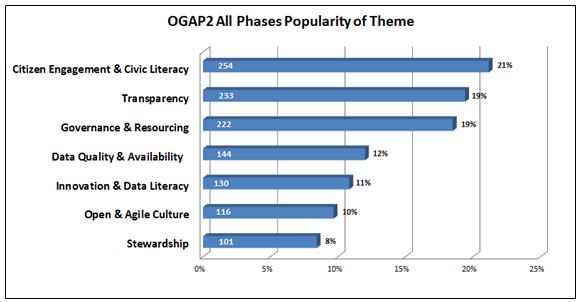
The report itself notes comments came from the Advisory Panel on Open Government, online forums, in-person sessions, email submissions, Twitter (hash tag #OGAP2), and LinkedIn. In general, participants requested quicker, easier, and more meaningful access to their government, and a desire to be involved in government decision making beyond consultations.

Some suggested that the Government of Canada could go even further toward improving transparency in the extractives sector. For example, proposed legislation to establish mandatory reporting standards could stipulate that extractives data be disclosed in open, machine-readable formats based on a standard template with uniform definitions.

figure5-eng

Major themes to emerge from citizen comments on the “What We Heard Report” (Image courtesy of the Government of Canada).

Find out more about this figure or the “What We Heard” report here.

If you have thoughts or questions about the article, get in touch with Drew Bush, Geothink’s digital journalist, at drew.bush@mail.mcgill.ca.
Spotlight on Recent Publications: Interrogating the Nature of Geosocial Data with Stéphane Roche

BEACONS

London Olympic wayfinding beacon (Photo courtesy of www.mudarchitecture.com).

By Drew Bush

In two articles published this January, Geothink researcher Stéphane Roche and his doctoral student Teriitutea Quesnot argue that not all geosocial data is equivalent, and that better data on the social significance of a landmark could greatly enhance our understanding of human wayfinding behavior. A Professor of Geomatics at University of Laval, Roche’s research over the past five years has focused on how new forms of digital spatiality affect spatial reasoning skills, and the capacity of individuals to engage in the city.

Entitled “Measure of Landmark Semantic Salience through Geosocial Data Streams,” the first paper was published by Roche in the ISPRS International Journal of Geo-Information. The authors write that a lot of research “in wayfinding is done in order to enable individuals to reach as quickly as possible a desired destination, to help people with disabilities by designing cognitively appropriate orientation signs, and reduce the fact of being lost.”

Previous researchers in the field of geo-cognition have tried to characterize the salience of landmarks in human wayfinding behaviour. Most have classified differing landmarks by visual, structural and semantic cues. However, the social dimensions of a landmark, such as how they are practised or recognized by individuals or groups, had been excluded from its semantic salience (or often reduced to historical or cultural cues), according to the authors.

Instead, the authors follow in a tradition of research which utilizes text mining from the web to understand how places are expressed by Internet users rather than relying on how they are visually perceived. Such an approach has been made possible by social media and mobile communications technology that has resulted in vast user-generated databases that constitute “the most appropriate VGI data for the detection of global semantic landmarks.”

In conducting their research, the authors examined world famous landmarks and detected semantic landmarks in the cities of Vienna and Paris using data from Foursquare API v2 and Facebook API v2.1. from September 29, 2014 to November 15, 2014.

In a second paper entitled “Platial or Locational Data? Toward the Characterization of Social Location Sharing,” the authors expanded on this theme in arguing that not all geosocial data is equal. The paper was presented at 48th Hawaii International Conference on Systems Sciences this past January.

Some data, which the authors consider “platial,” relates more to users experiences of a given place while “spatial” data is tied to the actual coordinates of a place. In the context of geosocial data, spatial data might mean the exact location of the Eiffel tower while palatial could refer to a person passing by the Eiffel tower or taking a photo of it from another location.

Because each can potentially represent a very different kind of data point, they must be treated differently. As the authors write, “With the objective of a better understanding of urban dynamics, lots of research projects focused on the combination of geosocial data harvested from different social media platforms. Those analyses were mainly realized on a traditional GIS, which is a tool that does not take into account the platial component of spatial data. Yet, with the advent of Social Location Sharing, the inconvenience of relying on a classic GIS is that a large part of VGI is now more palatial than locational.”

Find links to each article along with their abstracts below.

Measure of Landmark Semantic Salience through Geosocial Data Streams

ABSTRACT

Research in the area of spatial cognition demonstrated that references to landmarks are essential in the communication and the interpretation of wayfinding instructions for human being. In order to detect landmarks, a model for the assessment of their salience has been previously developed by Raubal and Winter. According to their model, landmark salience is divided into three categories: visual, structural, and semantic. Several solutions have been proposed to automatically detect landmarks on the basis of these categories. Due to a lack of relevant data, semantic salience has been frequently reduced to objects’ historical and cultural significance. Social dimension (i.e., the way an object is practiced and recognized by a person or a group of people) is systematically excluded from the measure of landmark semantic salience even though it represents an important component. Since the advent of mobile Internet and smartphones, the production of geolocated content from social web platforms—also described as geosocial data—became commonplace. Actually, these data allow us to have a better understanding of the local geographic knowledge. Therefore, we argue that geosocial data, especially Social Location Sharing datasets, represent a reliable source of information to precisely measure landmark semantic salience in urban area.

Platial or Locational Data? Toward the Characterization of Social Location Sharing

ABSTRACT

Sharing “location” information on social media became commonplace since the advent of smartphones. Location-based social networks introduced a derivative form of Volunteered Geographic Information (VGI) known as Social Location Sharing (SLS). It consists of claiming “I am/was at that Place”. Since SLS represents a singular form of place-based (i.e. platial) communication, we argue that SLS data are more platial than locational. According to our data classification of VGI, locational data (e.g. a geotagged tweet which geographic dimension is limited to its coordinate information) are a reduced form of platial data (e.g. a Swarm check-in). Therefore, we believe these two kinds of data should not be analyzed on the same spatial level. This distinction needs to be clarified because a large part of geosocial data (i.e. spatial data published from social media) tends to be analyzed on the basis of a locational equivalence and not on a platial one.

If you have thoughts or questions about the article, get in touch with Drew Bush, Geothink’s digital journalist, at drew.bush@mail.mcgill.ca.